More Golden Jubilee Celebrations: Monday June 3 2002 was the official Golden Jubilee Bank Holiday, and a number of events were taking place across the nation. And although I wasn’t myself celebrating I felt I should in some way document the events and picked a couple I felt might be of interest.
Here I’ll reproduce what I wrote in My London Diary in 2002 with the usual minor corrections, along with some of the pictures I posted back then, though the scans I made are sometimes rather primitive. I’ll also link to more pictures on-line, though there are still many from the day I’ve yet to digitise.
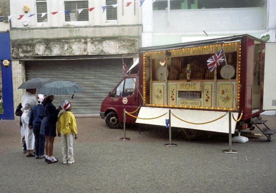
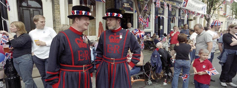
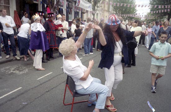
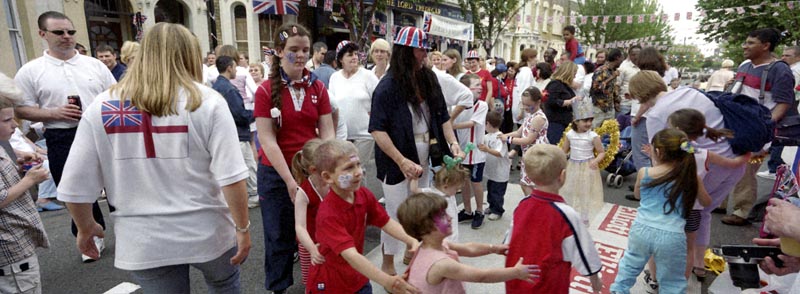
“June 3 I went to see how ordinary people were celebrating – first of all to a council organised even in Ilford, and then to a street party in the heart of the East End. “
Redbridge Jubilee Celebrations
Ilford High Rd, Ilford.#
Redbridge is in some ways one of the bleaker London boroughs, and the event seemed to lack any real centre or real conviction.
Perhaps the brightest point was the rain, which brought out a little of the true british spirit.
Mile End is also bleak when you emerge from the Underground, with too many lanes of road cutting through its centre.
To the north, and running up to the Roman and Vicky Park is one of the remnants of London’s East End, still with many of its Victorian terraces.
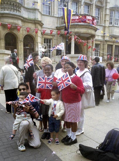
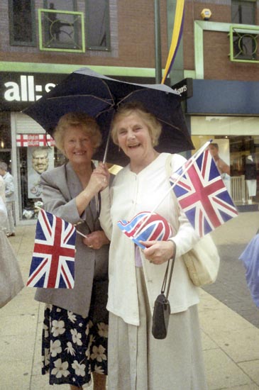
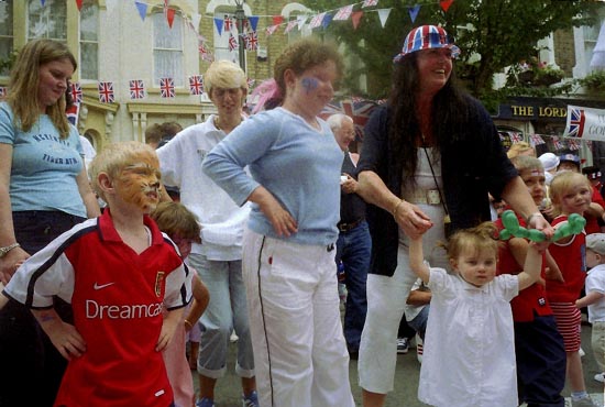
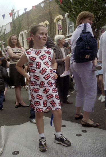
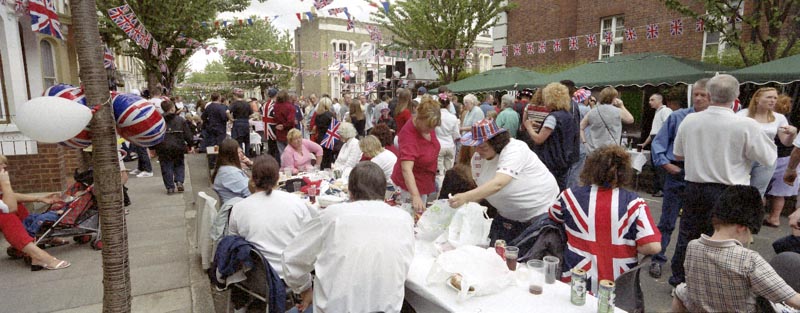
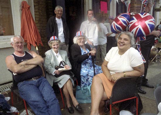
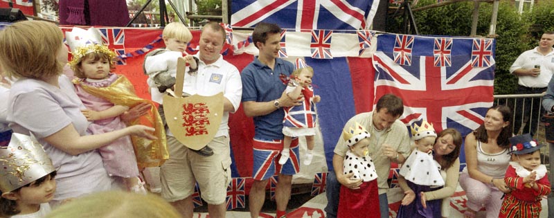
The street party was in full swing when I arrived and everyone was out to have a good time.
It was a great event for kids and for grandmas and everyone else, and the bar and the pub were doing good business too.
These were the real East-Enders – with a cast including a real Black Bishop in purple robes, two fancy dress Beefeaters, police who could almost have been from Dock Green (except for the hats), a fire engine and its crew and plenty of characters.
Not a single juggler, mime or performance artist in sight (sometimes I ask myself what did I do to father a unicyclist.) These were people who – like we all used to – could make their own entertainment.
Food, drink, chat, music, a bit of a dance, games for the kids. It was a street rather like the area I grew up in fifty years ago, where everybody knew each other, although now with a rather more multi-ethnic population.
People – apart from the odd shy kid – were happy to have their pictures taken and to talk. One man saw I was photographing the decorations on his house and came over to tell me how his father had decorated it for the Silver Jubilee twenty five years earlier and that he had been determined to do it better.
They hadn’t quite got to a real full-blown knees-up, but it seemed definitely on the cards but it was time for me to go. As I walked away three young women were walking towards the party on the other side of the street, “D’you wanna take our picture“, one shouted, seeing my cameras. “No film left” I replied.
The following day I meant to go out and take more pictures of other Jubilee events, but in the end I couldn’t make it, just feeling it would be too much of an anti-climax.
There are six pages with pictures from the celebrations in Bow. Back in 2002 we were still on dial-up connections and so images were spread out only a few on each page to give sensible loading times. Images were then shared on the web at much lower quality than we would use now. The links to the next page are usually above the final picture and the final page from the event is of black and white images.
Poplar, Bow, Leyton, North Woolwich & Silvertown: These pictures come from a number of visits to areas of London working on several different projects and are my final selection of colour panoramas made in 1995. There are a few more colour images, including some panoramas I made in 1995 in the images in the Flickr album as well as many I have not digitised; some very similar to those online, others that I now find of less interest. Some of these were taken as a part of my project on the Greenwich Meridian in London – you can see a set of 16 images from this on the urban landscape web site.
Bow Locks, River Lea, Bow Creek, Bow, Tower Hamlets, 1995, 95p4-752
Bow Locks separate the tidal River Lea from the Lea Navigation and the Limehouse Cut which offers an alternative route to the Thames to avoid the winding and dangerous Bow Creek. First built in 1850 they were remodelled in 1930. At the highest Spring tides water from Bow Creek would overtop the locks and raise the level of the canals here – the locks were modified in 2000 to stop this and avoid the silting it caused.
London Galvanizers, Leven Rd, Poplar, Tower Hamlets, 95p4-743
The Poplar Gas Coompany built a local gas works here in the 1820s at the request of the Poplar Vestry after ratepayers lobbied them to provide gas street lighting. The site was cleared in 2011 and I was commissioned to photograph the removal of toxic earth from the site using barges on Bow Creek. Something around an eigth of the material was removed in this way, tides making the removal of more difficult. The original gasholders had to be built to special safety standards because of their proximity to the West India Dock wall. The last of the gasholders was removed in 2017.
London Galvanizers had modernised their galvanizing plant here in 1983-5 and were one of the most important jobbing galvanizers in London and the Home Counties.
This street corner is close to the Meridian and I had stood here for some time outside the Chinese restaurant which was having some joinery work done. I liked the contrast between its orange paint and the blue on the opposite corner and the warm brown of the Birkbeck Tavern at right. I think I had made at least one exposure when a young girl in a red coat on roller skates came to see what I was doing – and I made this exposure as a red car come around, filling an otherwise rather empty grey space.
The Meridian also passes through this cemetery and I chose a viewpoint which included the cemetery chapel with a fine group of monuments in the foreground, I think all for people of Italian origin.
Stratford Station, Great Eastern Rd, Stratford, Newham,1995, 95p4-963
I’m unsure what this railway building to the east of the station was, perhaps a 1930s signal box. Parts of this area have now been redeveloped, and this has been behind fences for more than ten years and could stil be there, as least in part.
King George V Dock, Woolwich Manor Way, North Woolwich, Newham, 1995, 95p9-171
Finally four pictures from a walk along Woolwich Manor Way, this taken looking westwards along the south side of the King George V Dock. You can see the bridge over the dock entrance at right and the City Airport terminal and Canary Wharf at the end of the dock.
Royal Albert Dock Basin, Woolwich Manor Way, North Woolwich, Newham, 1995, 95p9-161
At left is the old swing bridge that took the road over the dock entrance from the basin. To its right is the elevated DLR and the pumping station at the centre of the Gallions roundabout. Further on only two buildings were standing along the side of the Basin, the Gallions Hotel and the Royal Docks Pumping Station.
Containers, Woolwich Manor Way, North Woolwich, Newham, 1995, 95p9-162
Land to the south of the Royal Albert Dock Basin just east of Woolwich Manor Way.
King George V Lock, Woolwich Manor Way, North Woolwich, Newham, 1995, 95p9-153
This swing bridge across the dock entrance is still there.
Royal Victoria Dock, Silvertown, Newham, 1995, 95p11-262
This was taken from Silvertown Way, looking across the Royal Victoria Dock. There are still cranes along the dockside here but the foreground now has flats. The Millenium Mills are still there, but there is nothing in the picture where the Excel Centre now stands and none of the other new developments on the north side of the dock. The council flats at the right have been demolished.
You can see these and some other colour pictures I took in 1995 at 1995 London Colour.
Lea Navigation & Olympic Site: Saturday 1 October 2011 was a fine day and I decided to go early to Stratford and take a photographic walk around Bow & Stratford Marsh, before a meeting at the View Tube on the Greenway overlooking the Olympic site.
I took the Jubilee Line to Stratford and then walked over the footbridge leading to the Carpenters Estate and then on to Stratford High Street. A great deal of new building was taking place there, including a new bridge to carry the Olympic crowds across the busy road on a route from West Ham station along the Greenway. The bridge was demolished shortly after the games ended.
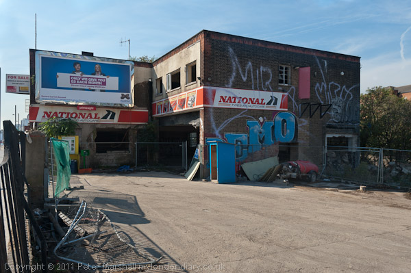
This section of the Greenway – the path on top of Bazalgette’s Northern Outfall Sewer rebranded in the 1990s – was closed off by fences and I kept on walking down the High Street. A few yards along was one of the few remaining commercial sites, though by then derelict and for sale. It was demolished and the site flattened for the Games, though it was only five years later than penthouses on the new block here were offered for sale.
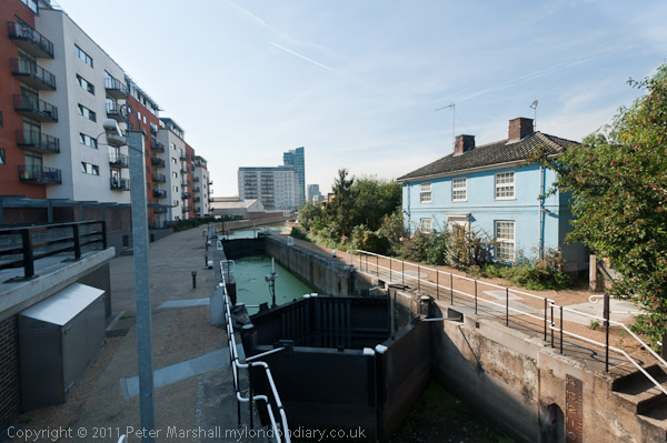
A few yards off the High Street was City Mill Lock, now behind a row of flats. I continued on to the Lea Navigation. The industrial sites on the High Street had now been cleared and there were now huge advertising structures.
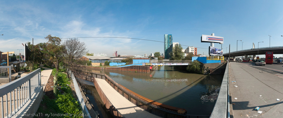
I had come mainly with the intention of making panoramic images, but these don’t display well on this blog, but you can see them larger on My London Diary. A footway now carries the towpath under the Bow Flyover and the High Street and then across the canal where the towpath continues on the opposite bank.
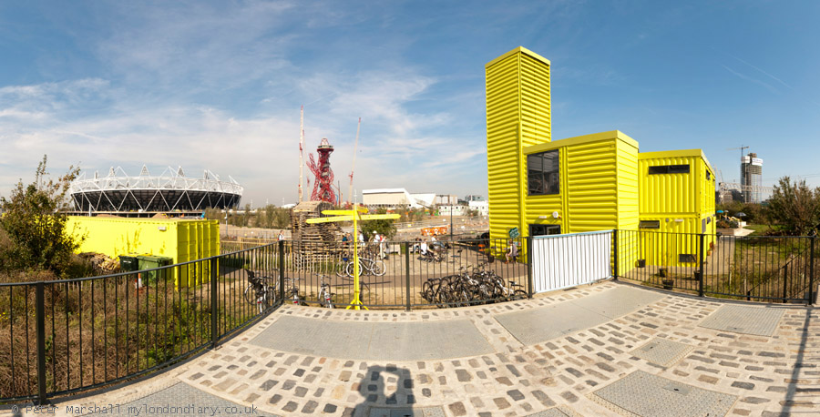
I made far too many pictures around this part of the canal before I could drag myself away, although the sky was not at its best for panoramic images and I would have prefered more distinct clouds rather than the large areas of blue. Only the first section of Cook’s Road was still open, but I could walk along beside St Thomas’s Creek to Marshgate Lane and then make my way to the bright yellow View Tube.
Here I was one of five photographers taking part in what was billed as a ‘Salon de Refuse Olympique‘, showing our artistic responses to the area. It was interesting to see the very different work that the five of us presented. You can read more about this in a post published here two days after the event in 2011, Northern Outfall Sewer 1990, 2005, 2010… which includes the three pictures I contributed for a forthcoming book as well as a lengthy text based on my presentation.
The Olympics have certainly changed this area, and the changes which were showing back in 2011 have continued. Many more pictures – both panoramic and normal aspect ration – in my post on My London Diary at Lea Navigation & Olympic Site.
Conscientious Objectors, Olympics, Cleaners, Iraq & An Opening – Back in 2008 I had rather more stamina than now and my day on Thursday 15 May 2008 included three protests and a walk around the outskirts of the closed Olympic site, ending with attending an exhibition opening in Brixton.
International Conscientious Objector’s Day – Tavistock Square
I’ve just checked on a web site which events are marked on 15th May, and although it lists nine, including National Nylon Stocking Day, it fails to mention the most important of all, that this is Nabka Day remembering the Palestinian Catastrophe, the violent ethnic cleansing of Palestinians from their land, belongings and homes following the establishment of Israel in 1948.
Long commemorated by supporters of Palestian rights, the commemoration of the 75th anniversary in 2023 was recognised by a UN General Assembly resolution. Today many are marking this around the world with events in many UK workplaces and Saturday 18th May there is a national march in London for Nabka 76 calling for and ent to the genocide in Gaza and for the UK to stop arming Israel.
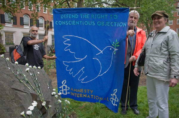
Less well known (and also not mentioned on that web site), May 15th is International Conscientious Objector’s Day, first observed in 1982 as a European day and in 1985 adopted by War Resisters’ International. In London today (15 May 2024) there will be a ceremony in Tavistock Square as there was in 2008, though starting an hour later at 1pm.
In 1987 the United Nations Commission on Human Rights recognised “the right of everyone to have conscientious objection to military service as a legitimate exercise of the right of freedom, thought, and religion“. However in many countries around the world this right is still denied.
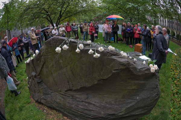
Tavistock Square has a number of memorials including at the centre of the garden a statue of Mahatma Ghandi given to the city of London in 1967 by the Indian High Commissioner, and a cherry tree planted by the then mayor of Camden Millie Miller in 1967 to commemorate the victims of the Hiroshima bombing, as well as a memorial to the holocaust. On the railings of the square is a memorial plaque to those killed in the bus destroyed in the square by the London suicide bombing of 7 July, 2005.
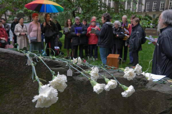
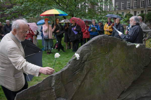
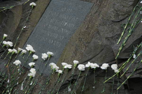
At the north end of the garden, close to the cherry tree, is a large grey rough-hewn boulder of Cumbrian slate was unveiled in 1994 as a memorial to conscientious objectors by composer Sir Michael Tippett, himself a conscientious objector, and people gathered on the grass in front of this.
After speeches and songs Bill Hetherington of the Peace Pledge Union read out the names and gave brief details of individual COs, past and present, from over 80 countries around the world, as a small representation of those who, as the words engraved on the memorial read, “…have established and are maintaining the right to refuse to kill.“
As the names were read, those taking part brought up white carnations – a symbol of the peace movement – and laid them on the stone. Each had on it a label with the country and name of a CO. The inscription on the stone continues: “Their foresight and courage give us hope.”
I had time before the next protest to go to Stratford and make my way around the southern edge of the Olympic site, now surrounded by a tall blue fence.
I went as far as the Lea Navigation where I photographed the notice closing the entrance to the Bow Back River channels which run through the site to navigation.
From the Greenway I could see huge piles of earth which are having to be processed because of their contamination from years of industrial production on the site. The site area was more or less unrecognisable although the City Mill River still flowed through it. It was a dismal day, with light rain or drizzle and everything looked bleak.
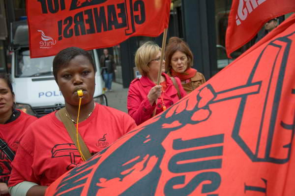
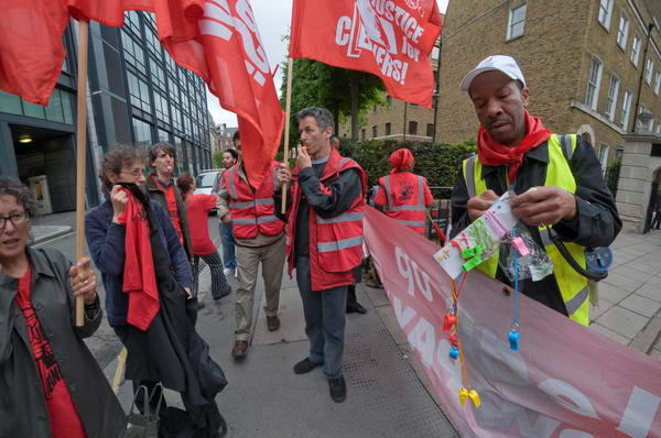
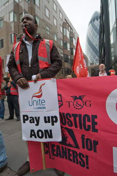
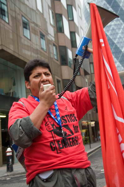
Justice for Cleaners brought together London’s largely migrant cleaners in a campaign for a living wage, sick pay, holidays, trade union rights and respect and was backed by major unions including Unite (and the TGWU which had then recently merged with Amicus to form Unite.)
On May 15th 2008 they had planned a protest outside the RBS offices in Bishopsgate, where cleaners were employed by Pall Mall, but negotiations had led to some success and the demonstration had been switched to AON in Devonshire Square, EC2, a short walk away.
AON, based in Chicago, is one of the world’s leading companies in insurance, with a first quarter net income for 2008 recently announced as $218 million. The cleaners at its City of London offices take home less than it takes to live on in London.
Their offices are on private property where I’d previously been prevented from taking pictures by security officers, and the protest took place in front of the gates on the street.
Noisy public protests such as these are effective because they draw attention to the shameful way these workers are treated even though they work to clean the offices of prestigious companies – which is why the Tories brought in highly restrictive laws in an attempt to stop them.
Watching them through the gates were a number of security men as well as City of London police. Workers in Devonshire Square were walking post the protesters and those inside the offices will have been able to hear the protest which took place with a lot of whistle blowing, shouting and a powerful megaphone used to express the cleaners’ demands.
Although Unite were supporting the cleaners here, migrant workers in London soon largely lost confidence in them and other major unions, who they felt were at times making deals with management that were not truly reflecting their interests, particularly in some workplaces where they seemed to be more interested in preserving wage differentials than getting good deals for the poorest workers. The cleaners – and many other low paid workers – are now largely represented by grass roots unions such as United Voices of the World.
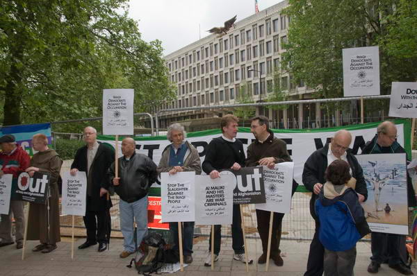
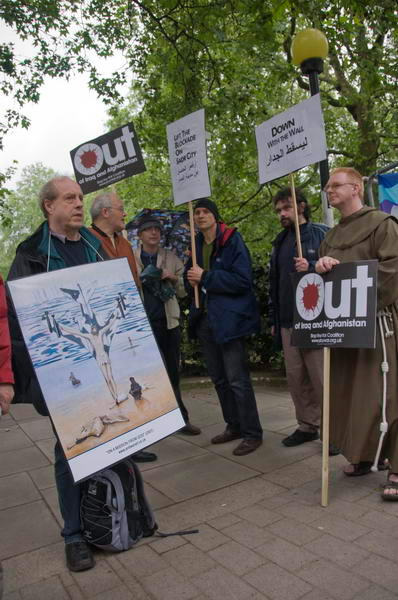
Iraqi Democrats Against the Occupation – US Embassy
Stop the War Coalition and Iraqi Democrats Against the Occupation protested at the US Embassy in Grosvenor Square calling for an end of actions against the Iraqi people and the withdrawal of US forces.
They handed in a letter condemning the continuing US occupation which had caused an “unimaginable level of death and destruction to the people and country in the past five years” and noting the similarity between US actions and the Israeli repression of Palestinians, with the building of concrete walls to divide Baghdad into what Pentagon sources have described as “30 killing zones“.
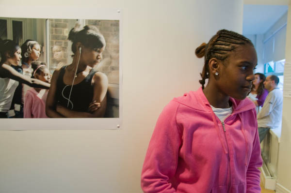
On my way home I took a few pictures of Brown Hart Gardens in Mayfair before going to Brixton to view the opening of the ‘Changing Places‘ show.
This picture wasn’t posed – I just walked up to look at the photograph by Simon Rowe and saw the young woman standing there with her head at a very similar angle. You can see a few more picture from the opening on My London Diary.
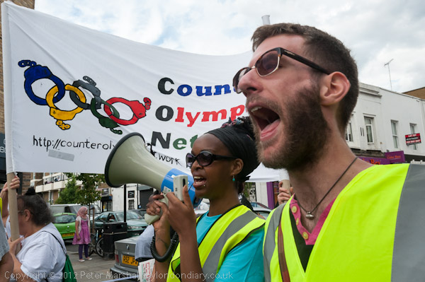
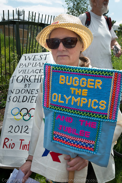
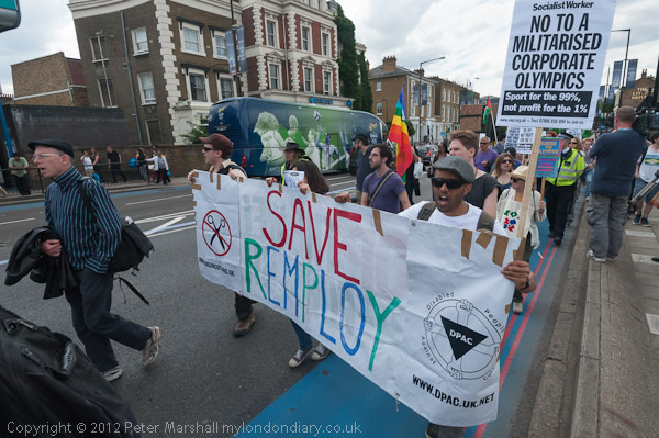
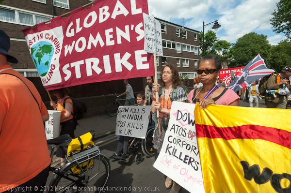
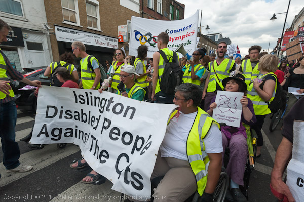
Ten years ago on July 27th 2012, as the London 2012 Olympics were getting underway in Stratford, people, mainly from the local area, marched to call for an end to the corporate takeover of the Olympics and the draconian policing and military presence largely aimed at the protection of brands and for the games to meet its legacy promises.
The authorities had done their damnedest to stop the protest taking place – first they had tried to ban it altogether, then Transport for London had refused permission for them to march along any roads which were emergency backup Games routes. But protesters agreed with police that they would leave the road if there was any emergency. Tower Hamlets council tried to ban any speeches or other events on Wennington Green where the march ended, and protesters were threatened they would be arrested if they carried banners, placards or t-shirts with political messages – though it was hard to see any legal basis for doing so.
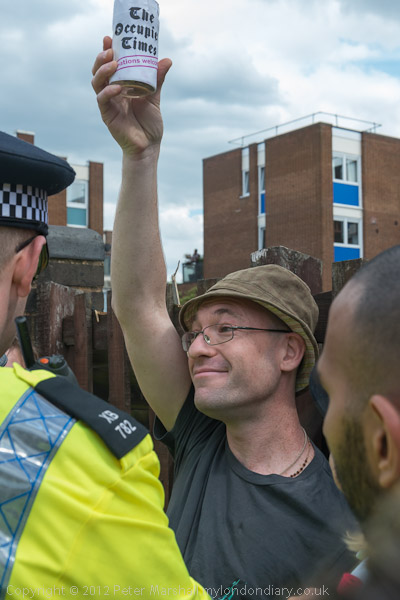
The ‘Whose Games? Whose City?’ protest went ahead despite the threats, with only one small incident when police seized and searched a man who had cut a piece of police tape. A crowd of marchers supported them and shouted for his release and after a few minutes he was set free without charge and the march continued.
The threats and public controversy had doubtless persuaded many not to come to the event, where around 500 marchers mingled with press and TV from around the world at the starting point in Mile End Park at midday. The organisers, the Counter Olympics Network (CON) had made clear that they were not against the Olympics as a sporting event but against the way it had been taken over by corporate interests. In my long account of the event on My London Diary I quoted from several of their statements, including:
"the close ties between the Olympic brand and its corporate sponsors who, despite IOC claims of vetting on ethical grounds, include serial polluters, companies which seriously damage the environment and which wreck or take lives, Coca Cola, Rio Tinto, BP, Dow Chemical. G4S, Cisco, and Atos deny people their human rights in a variety of situations while Macdonalds helps to fuel the obesity epidemic. London2012 provides benefits at taxpayers’ expense while receiving little in return."
CON also pointed out the many broken promises made about the games and the very doubtful legacy the games will leave, particularly in East London.
"the lack of benefits for local people and businesses, the fantastic expansion of security into our daily lives, the deployment of missiles and large numbers of troops, the unwarranted seizure of public land at Wanstead Flats, Leyton Marsh and Greenwich Park."
A man celebrates after the crowd made police release him
Later in his speech on Wennington Green, Chris Nineham of the Stop The Olympic Missiles Campaign declared that the London Olympics had already set a number of records, including the largest ever number of arrests on the first day, the highest ticket prices, the most intensive application of branding rules and the highest level of militarisation of any Olympic games, with far more being spent on security that even in China. There were now more troops in London than at any time since World War 2, and more than at any time in Afghanistan, where our military activities were now making us a terrorist target in London. Among the other speakers was Melanie Strickland, one of the 182 ‘Critical Mass’ cyclists arrested the previous night for riding near the Olympic stadium.
Industry on the Olympic site, Marshagate Lane, 1990
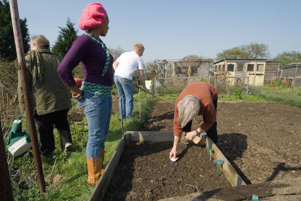
I had known and photographed the Olympic area since the early 1980s until the public were all excluded from the vast site in 2007 and after when we were only able to peer over the blue fence. In 2010 I brought out a book ‘Before The Olympics’ which included many pictures of the area in the thirty years or so before they took place, as well as looking more widely along the length of the River Lea and the Navigation. Most people miss that parts of the area were formerly thriving industrial and commercial sites, others a verdant wilderness – and of course some thriving allotments. Of course there have been some benefits following 2012 – more housing is something London desperately needs, but much was already being planned before the bid succeeded. But the park remains to me deeply disappointing.
Allotments on the Olympic site, April 2007
The book is still available and you should be able to view a preview at ‘Before the Olympics‘ though Blurb appears to be having some problems at the moment; it is a ridiculously highly priced softback, but there is a more reasonable PDF version. The book includes many of my pictures of the area which are also on my The Lea Valley web site including mainly black and white images from the 1980s and 90s and colour from the 2000s. Later images from before and after 2012 are on various pages of My London Diary. There is a large collection of the black and white images in my Flickr album River Lea – Lea Navigation 1981-1992 including many from what became the Olympic site.
Roman Rd, Bethnal Green, Tower Hamlets, 1988 88-8c-64
It’s doubtful if the Romans ever marched or walked along Roman Road, although some Roman remains have been found in the area. But most will have gone along Old Ford Rd which runs parallel a short distance to the north, it’s ford taking them across the River Lea from Londinium to the Iceni capital Venta Icenorum around 5 miles south of modern Norwich.
Most of Roman Road was only built when the sewer system was extended by the Metropolitan Board of Works in 1855 to allow further development in the area around, extending what was then Green St to the east, beyond Grove Road into Old Ford to an end a little short of the Lea. The western section from the Cambridge Bridge Road was only renamed to be part of Roman Road when London street names were rationalised in the 1930s – there were far too many Green Streets. It makes consulting old sources of information about shops and houses on the road difficult as all the street numbers then changed. The market in Roman Road was set up in the late 1860s.
Roman Rd, Bethnal Green, Tower Hamlets, 1988 88-8c-65
The whole area was a stronghold for the suffragettes, particularly after the formation of the East London Federation of the Women’s Social and Political Union by Dr Richard Pankhurst and his wife Emmeline Pankhurst, founder members of the Independent Labour Party in the same year, 1893. This was unusual in welcoming men as members and also having a democratic organisation. Their daughter Sylvia Pankhurst and the East London Federation were expelled from the WSPU in 2014 and set up the East London Federation of Suffragettes (ELFS) and set up a newspaper, The Woman’s Dreadnought, published from Roman Road. In 1917 its title was changed to Workers’ Dreadnought, with the slogan ‘Socialism, Internationalism, Votes for All’ and it continued in publication until 1924.
The East End was a very political area, but not only for its suffragettes and socialists and in the 1930s became of the the areas of strongest support for Oswald Mosley and his British Union of Fascists. Their support came mainly from the middle classes in the area, shopkeepers and other traders and business owners rather than the working class, but it was strong enough for the area to have two BUF branches until it was proscribed under Defence Regulation 18B of the Emergency Powers (Defence) Act 1939.
Roman Rd, Bethnal Green, Tower Hamlets, 1988 88-8c-66
Bethnal Green was badly affected by bombing in World War II and the Metropolitan Borough of Bethnal Green carried out extensive building of council housing in the 1950s and 60s, with some outstanding architecture close to Roman Road. In 1965 Bethnal Green merged with Stepney and Poplar to become the London Borough of Tower Hamlets. The area has in more recent years become considerably gentrified, a process which was beginning to be clear when I took these pictures in 1988.
Star Auto Electrics, Tredegar Rd, Bethnal Green, Tower Hamlets, 1988 88-8c-52
South of Roman Road and roughly parallel to it is Tredegar Road, built up in the 1850s and 60s. Star Auto Electrics fortunately informs us it was at 123A Tredegar Rd. This is now the site of a large block of flats.
Star Auto Electrics, Tredegar Rd, Bethnal Green, Tower Hamlets, 1988 88-8c-54
This neat late nineteenth century terrace is still there on Tredegar Rd. The street – like the rather better known (and roughly four times as expensive) Tredegar Square close by south of the railway line gets its name from Lord Tredegar, Sir Charles Morgan (1760-1846) who made a large fortune promoting agriculture in south Wales and in 1824 was granted a private act of parliament by King George IV to develop a large area of Mile End and Bow. Although several of the streets are named after places in Wales, they have not inherited a Welsh pronunciation.
This picture was made at the junction of Tredegar Road at its west end with Coborn Road, though nothing in the picture remains. A few yards away around the corner in Coborn Road there are some older buildings and the site of the former railway station, opened as Old Ford in 1865, later renamed as Coborn Road and then Coborn Road for Old Ford which was permanently closed and largely demolished in 1946.
Roman Rd, Bethnal Green, Tower Hamlets, 1988 88-8c-45
My walk ended on Roman Road, where I joined a queue at a bus stop waiting for the bus to take me back into the City and from there by Underground and British Rail back home.
Click on any of the pictures to see a larger version in my album 1988 London Photos, from where you can browse the album.
This is the east side of the Bryant and May match factory. The main Grade II listed building was built in 1909-10, architects Holman and Goodsham, making this the largest match factory in Britain. But parts of the building are earlier, and Quakers, William Bryant and Francis May who had gone into business making matches in 1843 (at first because of their religious conviction only making safety matches) moved to a former candle factory on Fairfield Road in 1861. Various new buildings were added before the 1910 building. The factory closed in 1979, was listed in 1988 and is now the Bow Quarter, a gated private estate with 19 houses and 714 flats. The building at right of the picture was demolished and replaced by a new block.
But safety matches, which needed a special striking surface containing red phosphorus were not as popular as the strike-anywhere matches (lucifers) made with the more dangerous white phosphorus in the match-heads and the factory soon switched to producing these as well. The relatively few men and the several thousand “matchgirls” working in the plant, mainly of Irish descent, commonly suffered from phosphorus necrosis of the jaw, known as ‘phossy jaw’ cause by white phosphorus vapour. The first symptoms were usually toothaches – and the company insisted that any workers suffering got all their teeth removed or be sacked. This poisoning led to a disabled jaw and eventually to death in around a fifth of cases.
Complete removal of teeth was common in the UK before the beginning of the National Health Service after World War II, as only the wealthy could afford any proper dentistry. Toothache can be agonising and was often treated by tying strong twine around the offending tooth, fixing the other end to a door handle and getting someone to slam the door. Both my parents (born around 1900) were given full extraction of teeth and a replacement ‘Full Set’ of upper and lower teeth as a wedding present in 1932.
The match-girls were not only subject to this horrible occupational disease, but discipline at work was excessively strict, with fines taken from their wages for trivial reasons – lateness, a dirty workbench, talking or having dirty feet – as well as having to pay for their own glue and brushes. The sacking of one of the girls in 1888 provoked the Matchgirls Strike – which they won after two weeks, getting better working conditions and a proper grievance process and ending the fines and other deductions from their wages.
Old Ford Rd, Old Ford, Tower Hamlets, 1988 88-8b-12
This scrapyard, for all makes of car spares, open seven days a week was next to the A102 (M) East Cross Route, built between 1967 and 1973 as a part of Ringway 1, most of which was then quickly abandoned after it became clear the complete environmental destruction building it would take. It became the A12 after being transferred to TfL in 2000, as they were not given the powers needed to run motorways.
The massive 1970s slab block flats of Lefevre Walk were replaced in 1993-2006 by the Tower Hamlets Housing Action Trust with a mix of houses and flats with a traditional street layout designed in close consultation with the community.
Old Ford Rd, Old Ford, Tower Hamlets, 1988 88-8b-16
A view from the edge of the scrapyard.
Look, Roman Rd, Bethnal Green, Tower Hamlets, 1988 88-8c-63
As well as the Olympus SLR with which I made most of the pictures on my walks and with a second SLR body with colour negative film, I also carried a small Minox 35 camera in my jacket pocket whenever I went out. This was the smallest 35mm camera ever made, only 3.9 x 2.5 x 1.2 inches, just large enough to hold a 35mm cassette at on side and the take-up spool on the opposite side of the film gate. The 35mm f2.8 lens folded back into the camera body when not in use and the camera fitted easily even into a shirt pocket.
I had several models of the camera over the years, and often used it when I wanted to be less conspicuous, carrying the camera in one hand it was almost invisible. It was also virtually silent in operation. At times on my walks when I had packed away the SLRs in my camera bag it was more convenient to take pictures on the Minox, but the 36 exposure film might contain pictures from several walks and other occasions.
It isn’t always easy to fit the pictures into place in my walks but I think from Old Ford Road I spent some time taking pictures – including this and those below – on Roman Road in the centre of Bethnal Green, but they may have been made the previous day.
Roman Rd, Bethnal Green, Tower Hamlets, 1988 88-7u-12
Two women with a push chair on Roman Road talk as they walk along the street. Just visible behind them are two other children with them.
Roman Rd, Bethnal Green, Tower Hamlets, 1988 88-7u-13
Men walk on the opposite side of the stree in front of Shirley’s Antiques – Houses Cleared, with the text from a previous occupier still visible on the first floor frontage.
Roman Rd, Bethnal Green, Tower Hamlets, 1988 88-7u-15
Men walk on the opposite side of the street in front of Shirley’s Antiques – Houses Cleared, with the text from a previous occupier still visible on the first floor frontage.
The next installment on this walk will include more pictures from Roman Road taken as I made my way to Bethnal Green tube and the end of the walk.
You can click on any of the images to see a larger version in my album 1988 London Photos, from where you can browse the album.
The family vault of the Bear Family is marked by one of the more impressive monuments of Tower Hamlets Cemetery, with a long list of names, ages ad date of death which is headed by George Huxley Bear, who died in 1855 aged 4 years and six months. Several of the other entries are also for children, though their father lived to the age of 76. Child mortality was very much a feature of Victorian life.
I made two other pictures of this memorial, with its stems of wheat at the bottom and the consoling text from John XII, v 24 “Except a corn of wheat fall into the ground and die, it abideth alone: but if it die, it bringeth forth much fruit.” As with all the other pictures you can click on this one to get a larger version and then browse back and forward to see them.
Bromley Public Hall, Bow Rd, Bow, Tower Hamlets, 1988 88-8b-41
Until last year this was the Tower Hamlets Register Office. The Grade II listed building dates from 1880 and was built as the vestry hall for St Leonard’s parish and extended in 1904. At least one web site confuses this with the much older and very different Bromley Hall, on the Blackwall Tunnel Approach road, though to be the oldest brick building in London, built around 1490 but extensively remodelled with a Georgian frontage around 1700.
Former Co-op store, Bow Rd, Bow, Tower Hamlets, 1988 88-8b-42
Stratford Co-operative & Industrial Society built this splendid store on Bow Road in 1919, proudly listing the names of its leading members under the bee hive signifying co-operation.
In my youth every high street (and some rather lower) had its own Co-operative store, benefiting from the huge buying power of the Cooperative Wholesale Society. We bought most of the few new clothes we could afford there as well as shoes and other items, and it was the Co-op who delivered our milk seven days a week. My mother’s Co-op number is still etched in my memory, essential when making any purchase, and leading to a ‘divi’ at the end of the year which saw us through Christmas.
In 1988 this was the PLH Kakkad Supermarket and although it sold a wide range of goods its frontage was devoted to Rothmans, “The best tobacco money can buy“. More recently it became a Costcutter and then a Nisa local since around 2008.
Lea Navigation, St Thomas Creek, Bow Back Rivers, Stratford, Newham, 1988
I walked further east and crossed the busy Bow roundabout to take this picture looking across the Lea Navigation and up St Thomas Creek, one of the Bow Back Rivers. Stratford High Street at right is now lined with tall flats, and Global Caravans with one stacked on top of a couple of containers is long gone, along with almost all of the rest of the industrial buildings. A few of those nearest on the left before Cooks Road remained but in derelict condition in 2021.
Walking back west up Bow Road took me to Bow Theatre on the west corner of Fairfield Road. This Grade II listed building was a new Poplar Town Hall built in 1937-8 and was said to be the first modernist town hall, designed by Ewart Culpin and his son Clifford. The frieze by David Evans depicts the various trades of the builders of the town hall and is said to include a welder, a labourer, a mason, a carpenter and an architect. Unfortunately it is hard to decide the occupations of some of those in my picture, partly as they are not critically sharp.
After Poplar became a part of Tower Hamlets, this was no longer a town hall, but remained in use for some years as council offices and also as a theatre. The council sold it in the 1990s and it is now Bow Business Centre.
The Caledonian Arms on the corner of Blondin St is still standing but no longer a pub, having closed around 2000 and extensively converted to office and residential use in 2010. The building possibly dates from 1851 though it may have replaced a former building later that century. For years a Watney’s pub it later became owned by Shepherd Neame.
The cafe on the opposite corner has gone completely, its site part of a car park for new buildings down Blondin St. The name suggests that the street was built at the time of the famous tightrope crossing of the Niagra by ‘The Great Blondin‘ in 1859.
Douro St, Bow, Tower Hamlets, 1988 88-8b-35
This was a short street with small houses shown in the picture with front doors opening directly onto the street and a car breakers behind the fence at left.
The cobbles and the small houses are still there, but the car breakers have been replaced by a large block of flats, Altius Apartments, at 714 Wick Lane, with 4 floors and a roof garden, at a taller 9 floor tower at the east end. The guide price for one of those small houses in the ‘Bow Quarter’ is given as £800,000 and the estate agents rather creatively describe Douro St as ‘tree-lined’.
Tredegar Rd is just to the north of Douro St, on the other side of the flats. I think this is at its junction with Wick Lane and I think absolutely nothing of what was in my picture remains, with even the road layout having altered at least slightly.
What was H Bates & Son Scrap dealers is now occupied by a block of around 12 floors, offices at ground level and flats above, but the ‘Bow Quarter’ area is so different that this could well be another nearby corner – also covered with new housing. But my next pictures show I turned south down Wick Lane to the rear of the former Bryant & May match factory, where the next instalment of this walk will begin.
Click on any image to see a larger version in my album 1988 London Photos, from where you can browse other images. You can view most of the sites today on Google Streetview.
The buildings of the Diary and the Rose & Crown are still standing at the north end of Stroudley Walk where it meets the end of Bromley High St, but the closed diary became Hussains Convenience Store and then Jalalabad Grocers and half is now a mobile phone repair shop.
The Rose & Crown had opened here around 1720, as the Bowling Green Inn, though the building here is from the 1880s. It closed in 2007, was boarded up for some years before reopening around 2014 as a coffee bar and fast food restaurant.
This was formerly the north end of Devons Road, and a sign for this painted on the brickwork at the left of the pub had virtually disappeared when I made this picture in 1988. Later repainted it has now almost disappeared again.
I wrote more about Kingsley Hall and the sisters Muriel and Doris Lester in the previous post on this walk. They used a legacy from their younger brother Kingsley to set up a house where they lived in relative poverty and served the neighbourhood as well as campaigning for peace and justice across the world. A plaque on the building records that Mahatma Gandhi lived in a small cabin here during his three month stay attending a government conference as a representative of the Indian National Congress. You can read and see more about his visit and the sisters on the Muriel Lester web site.
This image gives a better view of the whole building, which dates from 1928. It faces the Devons Estate, built for the London County Council in 1949 and described by Pevsner as being in their ‘pre-war manner, but with all the drabness of post-war austerity‘. Those moved from slums into its maisonettes and flats would have taken a far more positive view and the estate was solidly built and well-designed to the standards of the day.
Clyde House, Bruce Rd, Bromley-by-Bow, Tower Hamlets, 1988 88-8a-26
Clyde House is still there at 46 Bruce Road, looking in rather better condition now. Built in 1884 it appears to have been built as a pair with its double-fronted neighbour at 48.
Sisters Muriel and Doris Lester helped to set up the Children’s House on Bruce Road 1923. Doris had trained as a teacher and they commissioned Charles Cowles-Voysey to design a building based on Maria Montessori’s ideal learning environment for young children. The school was opened in 1923 by H G Wells and is still a school, run by Tower Hamlets Council.
Inside there is a 12 metre mural painted in 1935 by Eve Garnett, the illustrator, artist and writer of the first children’s book about working class characters, The Family from One End Street, in 1937. There is now a campaign to save and restore the mural which is dirty and damaged and the web site is asking for donations to pay for this.
Regent Square, Bow, Tower Hamlets, 1988 88-8a-15
The Crossways Estate, built in 1970 was apparently at the time known as the ‘Pride of Bow’, for its three 25 storey towers and a low rise block, Holyhead Close, built over the railway line. Later it was more prosaically referred to as the ‘three flats.’
It was here that Grime developed in 2003, after Rinse FM squatted in a flat and broadcast illegally from here, and it was also where Dizzee Rascal and others grew up.
Like many council developments the area around the estate was hard to navigate, with walkways and roads often not shown on maps. My contact sheet says ‘Regent Square and gives grid reference 375827 for the first of the five images I made. The three towers were Hackworth Point, Mallard Point and Priestman Point and are on Rainhill Way.
And also like many council estates, it was subjected to a policy of ‘managed decline’ and by 1999 was in a very poor state, so bad its demolition was under consideration. Tower Hamlets decided to retain and refurbish the estate which passed to Swan Homes after a residents ballot in 2005. Its towers now refurbished and clad more brightly this is now the Bow Cross Estate.
The ‘three flats’ seen from Bow Road and Bow Church DLR station which opened on 31 August 1987.
Mornington Grove, Bow, Tower Hamlets, 1988 88-8b-61
Mornington Grove not only gets a mention in the London 5: East volume of Pevsner (p619) which describes these houses as “unusually grand for the area” but also has an extensive web site covering its history by Ken Ward, a resident in the street, from which this information is extracted – and which has far more detail. And it really is an interesting history – if you have the time do click the link and read more.
The land of a nursery here was bought by the Quaker meeting in Ratcliff in 1812, and houses on Mornington Road were developed by them from 1854-1889 – those on the east side in this picture being among the later development. Arthur Wellesley, the 1st Duke of Wellington was the son of the first Earl of Mornington, and the fourth Earl lived nearby on the north side of Bow Road.
Many of the houses in Mornington Road were compulsory purchased and demolished for the Whitehapel and Bow Railway (later the District Line) and others by World War II bombing of what had in 1939 been renamed Mornington Grove. Under the Quakers, at least 5/7th of the rents of the houses went to the support of the poor.
Most of the houses in the street, by then under multiple occupation, were sold by the Quakers to a housing association in 1980, becoming social housing, though many have now been sold off.
More from Bow in the next post from my walk in 1988. You can see larger versions of any of these pictures by clicking on the image which will take you to my album 1988 London Pictures from where you can browse.
Around Devons Road, Bow 1988. My previous post about my walk on Sunday 31st July 1988 ended on Rounton Road, but I knew I wanted to take more pictures in the area around Devons Road, so I headed back there.
Devons Rd, Bow, Tower Hamlets, 1988 88-7s-24
There is still a patch of grass and a zebra crossing here, close to the junction with Violet Road (now a mini-roundabout) but the bus shelter and the closer shops, including Hilton Furniture Centre, the Car Service, the Bookmakers and six more, some boarded up, which had been up for auction (by order of the L. R, B – “3 investment and 6 vacant“) six months before I took the picture are long gone. In the distance is the Lighthouse Baptist Chuch, still a local landmark.
The LRB was not of course the London Review of Books (as Google now thinks) but the London Residuary Body, set up in 1985 to dispose of the assets of the Greater London Council after its abolition by Thatcher in 1986, a decision which continues to blight London.
Service Station, Violet Rd, Bow, Tower Hamlets, 1988 88-7s-25
I was amused by Violet Road Service Station which appeared to me to be trying to be a caravan and had an impressive pile of wooden pallets on its forecourt. Long demolished and I think replaced by flats.
Works, Yeo St, Bow, Tower Hamlets, 1988 88-7s-26
The building at right with the exterior staircase in what seemed to me a 1950s style has been replaced by a Tesco Express and flats. The large pile of pallets and the caravan both connected in my mind with the the previous image I had made (above).
The low building on Violet Road at left survived into this century when it served as a huge billboard along the street for the Caspian Wharf development whose sales & marketing suite and showhome were in Yeo St, but was replaced by a 7-storey canalside block around 2012.
Spratts Patent Limited buildings are still there – one clearly being converted into flats when I made this image.
Glaucus St, Bow, Tower Hamlets, 1988 88-7s-14
I think this is the best of four frames (two on Flickr) I made of this heap of crumpled metal on the clearance site on Glaucus St and Yeo St. I couldn’t make up my mind exactly what it had once been.
According to the Greek myths, Glaucus of Corinth was a son of Poseidon who loved the beautiful nymph Scylla and who showed little interest even after had himself turned into a merman to pursue her. He made the mistake of going to her jealous rival Circe for a love potion which whem she swallowed it instead changed her into a sea-monster who went on to lived in the rocks beside the whirlpool of Charybdis.
However I suspect the street name did not come directly from the Greeks, but was possibly the name of one of the ships built in a nearby shipyard. The name is also used for a genus of sea-slugs and was the title given to a book of scientific reports on the voyages of HMS Challenter in 1873-6.
Glaucus St, Bow, Tower Hamlets, 1988 88-7s-15
Another view of the development site in Glaucus St.
Works, Yeo St, Bow, Tower Hamlets, 1988 88-7s-16
Yeo Street still contains some industrial buildings on the wharves along the Limehouse Cut, but this one is of the same site as a previous image in this post, now a Tesco Express and flats on the corner with Violet Road.
This was formerly Violet Street, and I wonder if the name may have been linked to dyes produced in chemical factories along the cut. Mauveine, the first synthetic dyestuff was discovered not far away by William Perkin working in the attic of his family home in 1856, though he set up his factory in Greenford. But the dye was a Victorian sensation and perhaps increased the popularity of the name Violet, though other flower names also became popular around the 1880s.
Violet Rd, Bow, Tower Hamlets, 1988 88-7t-61
Another view of the building on Violet Road, on the corner of Yeo St, which shows a similar external staircase on the opposite end of the building.
Morris Rd, Bow, Tower Hamlets, 1988 88-7t-62
Across the bridge over the Limehouse Ct, Violet Road becomes Morris Rd, and a board in front of Spratt’s Patents Limited tells us this is now Tower Studios and that the two luxurious penthouse appartments due for completion in May 1987 have now been sold.
Still more pictures from my walk on 31st July 1988 in a later post here.