The previous digest although titled Hull Photos: 5/7/17-12/7/17 actually also included the post for 13/7/17 – just showing I’m not too good at counting! Back to 7 days this time – comments and corrections welcome as always.
14th July 2017
There are around 30 vessels in the Old Harbour on the River Hull, mainly in front of the wharves which are at the back of the High St. What is perhaps shocking is the complete loss of those varied frontages on the left, down as far as the large and ugly block next to Scale Lane Staith. That was one which I would have been happy to lose, but the others in their variety were an important part of the cityscape that has been lost, replaced by the dull Trinity Wharf. It isn’t bad – which might be interesting – but dull and second-rate, clearly an opportunity lost.
Further down things are a little better, though the new is perhaps not always up to the standard of the old, and then, crossing the river we now see a horrible gap, the missing tooth of Clarence Mill, which although solidly re-built after the war to something less than its previous glory was a city landmark and an iconic reminder of Hull’s past and Rank’s pioneering achievements. It could and should have been converted to new use rather than demolished, and its loss is something Hull City planners should never be forgiven for. Fortunately my view in this photograph doesn’t extend to the site of the Holiday Inn.
It is an interesting selection of vessels, including two former lightships, one the Middle Whitton and the other at left looking rather like the Upper Whitton, though it has no visible name on it. These were some of the last manned lightships to be replaced by unmanned floats with solar cells to provide power and had a two man crew who did I think two week shifts. The Whitton sands – between Brough and Whitton across the river were notorious. The Middle Whitton apparently became a houseboat named Audrey and was certainly for some years on the canal at Beverley.
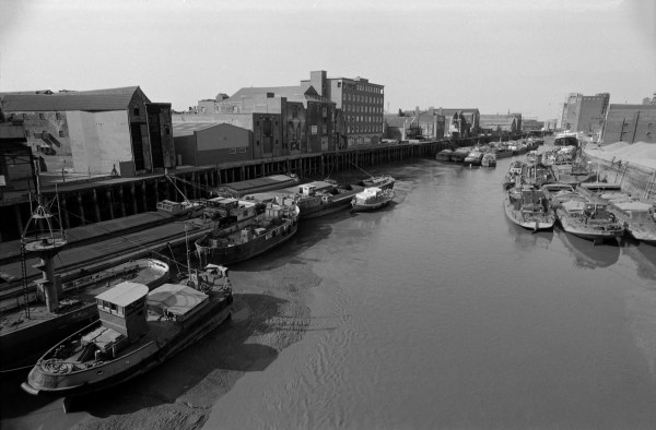
36f14: The Old Harbour, River Hull from Myton Bridge, 1983 – River Hull
15th July 2017
My favourite Hull footpath led across the walkway on the side of this swing bridge over the dock entrance and then between the railings and up the steps from which I took this picture to go along the roofs of the dockside warehouses.
A stern notice on the bridge warns you against entering the bridge when the guard chains are across the bridge approaches – and that you will be prosecuted if you get through under or over the guard chain.
But by this time there were no guard chains across the public footpath, and the flashing lights warning of its opening were of little use if you had already walked past them, and a couple of years before I took this picture, my wife, walking slowly pushing a buggy with my younger son in it was crossing slowly, perhaps having stopped to admire the view, when the bridge began to swing.
It wasn’t at that time a heavily used path, something of a secret known to relatively few who hadn’t worked in the docks, and probably the bridge operators had not thought to check there was nobody already on the bridge when they pressed the button for the lights and then for the bridge to swing.
I can’t recall ever meeting another person when I used the path back in the 1980s, but now it is a highlight of the Trans Pennine Trail, and when I visited it last on a fine day in February there were quite a few locals coming to stop and look at the view and to take photographs as well as several walkers setting out towards Southport, or at least on this section of the long-distance path.
I was rather sorry I wasn’t with her – perhaps it would have been a good photo opportunity – but I had walked a little further on with our elder son, and after a while was beginning to worry what had happened to her, though I think was still more interested in taking pictures.
Of course she wasn’t prosecuted – and I think got an apology for having been put in a not very dangerous situation. But Hull’s relatively new Scale Lane footbridge (built to take you to the Holiday Inn?) riding on the bridge is allowed – apparently when it was built the only such bridge in the world. The opening times – currently once every Saturday and twice on Sundays – are listed on the council web site, and it is one of Hull’s best-hidden tourist attractions. Theoretically it also opens for river traffic, though there is little of this now, and smaller craft can pass under the bridge without needing it to open. I think it has greater river clearance than either Drypool or North Bridges.
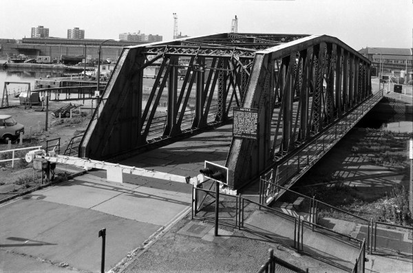
36f44: Swing Bridge, Albert Dock entrance lock, 1983 – Docks
16th July 2017
I have struggled to find where I took this picture without being able to definitely place it. The chimney in the background is that of Smith & Nephew, just a little west of Ropery St, south of Hessle Rd. There are still five existing smokehouses in the area, two in Daltry St, one in Ropery St, one in Alfred St and the last in English St, but none appear quite to fit the profile of this one, or to have a roof at the correct angle when viewing the chimney.
Nor can I find any building like the main one in the image, quite distinctive with that cut-away corner and external drainpipes. Above the lorry entrance is the name, its start and probably end missing ‘istocrat FOOD’. There was a company listed as ‘Aristocrat Foods Ltd’ but it was in Bransholme. The building at right has a sign too, though again only a part is visible, with the logo ‘nexem’ or ‘nekem’. Surprisingly there is (or was) a Nekem Ltd in Hull, but in a different area with a different logo. Neither does the incomplete name ‘J Stanley Hol’ yield me any clues – though I’m sure there will be someone from Hull able to recognise the location.
Other images taken before and after this are in the I think it likely that the smokehouse and the rest have been demolished and replaced by other buildings. The location that seems most likely is on Edgar St at the corner of Mechanics Lane.
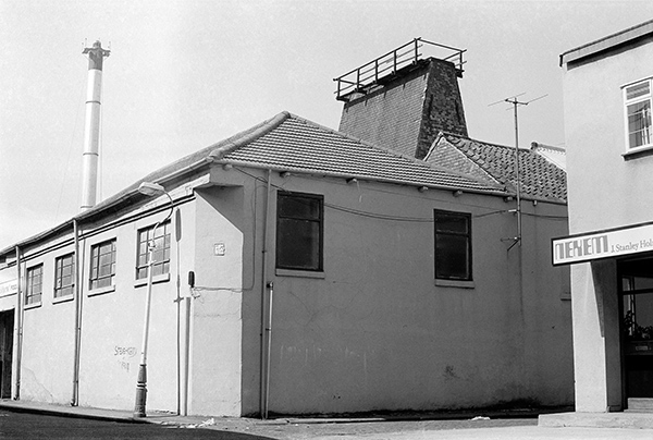
36f61: Works and Smokehouse, possibly Edgar St, 1983 – Hessle Rd
17th July 2017
Obviously the name St Mark’s Square was a part of its attraction to me, but this was also an important site in the growth of Hull, the centre of Hull’s first out of town suburban development by Thomas English, a wealthy local shipbuilder in the first decade of the nineteenth century in an area then known as the Pottery Ground, south of the Hessle Rd. The square was then an open area surrounded by houses, but I could see no trace of that.
The cobbled area at the right and the high brick wall of an industrial building with above it the chimneys and cowls of a fish smokehouse are St Mark’s Square, and Clyens & Son Monumental Masons where two men are enjoying a break at 36 St James St. This is the best of three pictures I took with them in it.
The buildings and the cobbles are still there, though altered. The smokehouse has lost its chimneys and been capped with a roof, while the entrance in which the two men are sitting has been replaced by a wider shuttered opening. The name board has gone and a notice on the side of the building now has an arrow pointing to Wyke Electrical Controls. A faded notice for the yard behind reads J A Lorrimar & Co., Weighing Machine & Slicing Machine Specialists – Food Preparation Equipment, and the whole area was and is a maze of small industrial premises. The was still a board reading Clyens & Son Monumental Masons when Google Streetview first photographed the area in 2008, but the company is no longer at 36 St James Street, but at premises off the Hedon Rd in East Hull.
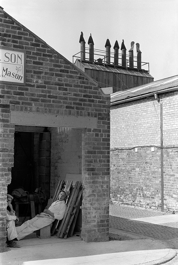
36f65: Clyens & Son Monumental Masons and St Mark’s Square, 1983 – Hessle Rd
18th July 2017
Still a familiar view, although Pauls has Changed to maizecor and that tall square brick chimney has disappeared.
I was for a while puzzled by the raised section of pavement here but much of Hull is subject to occasional flooding. The low brick wall at right of the picture is I think were the Cottingham Drain went under the road. This was culverted ten or more years before I took this picture, although at least until recently there was a little muddy area visible on that side of the road. The course of the drain through Hull can easily be seen, with a roadway, cycle path or footpath alongside most or all of its course – and the end of the footpath can be seen here running along the side of the building complex.
This area, where the Cottingham and Beverley & Barmston (‘Barmy’) drain enter the Hull is known as ‘High Flags’ and although this is often thought to refer to large paving stones on the nearby wharf where whale oil drums were handled, I wonder if it could simply have been a reference to this causeway needed along an often flooded section of road. High Flags Mill, a Grade II listed Oil Mill built around 1856 is a short distance to the north. Originally operated by Chambers and Fargus it was Hull’s last expelling mill when it closed in 1991.
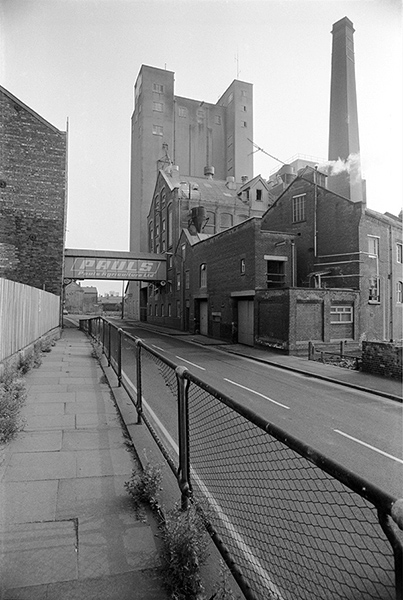
36g11: Wincolmlee, looking south towards Pauls Agriculture Ltd, 1983 – River Hull
19th July 2017
Another Chambers and Fargus mill on the east side of the Hull immediately below Scott St Bridge. This picture is taken from close to the bridge looking roughly south down-river. It still looks much the same, and is still busy, though now for Finlays, tea and coffee importers.
On the right bank, only the closest building on Wincolmlee still stands, and, in the far distance, North Bridge and the former ship’s warehouse next to it. Further down, Clarence Mill and the sites along Wincolmlee stood completely empty with just a little rubble when I walked past earlier this year.
Gino of Rochester, berthed at the mill was a general cargo coaster, originally called Ambience and built in Hull at the Drypool Engineering and Drydock Co, a ship repair company founded in 1921 by the Rix family which was liquidated in 1975, when two of its drydocks were sold to the Yorkshire Drydock Co of Hull; she became Gino in 1982. Gross weight 391 tons she was eventually sold to Qatar (along with apparently most of the UK) but unfortunately sank after breaking tow in Qatar in 1997.
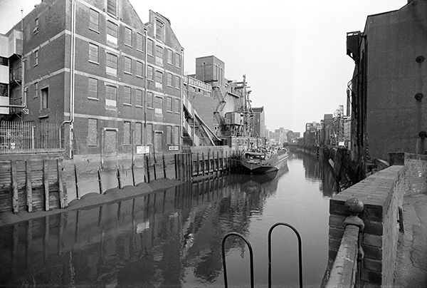
36g14: River Hull, view downstream from beside Scott St Bridge, 1983 – River Hull
20th July 2017
The Whalebone Inn has gone up in the world without losing it’s unique character since I took this picture, and is now described as Yorkshire’s hidden gem and was Hull and East Yorkshire CAMRA Pub of the Year in 2014 and 2015.
The ramshackle lean to at right disappeared years ago leaving a small open yard. The pub has its main frontage on Wincolmlee, which is around three times as wide but was also in fairly poor shape back in 1983. Then it rather seemed the sort of pub you would only enter with backup, but it is now far more welcoming.
This area, some distance north of the old city of Hull once used to be known as Wapping, probably meaning it was marshy, and streams and dykes have run through here to the River Hull since medieval times. The inn is said to date from 1791, but has had a few updates since, and the buildings look basically early nineteenth century, when it had a brewery opposite and another a few yards down Lincoln St, with three more only a little further distant and from 2003 to 2015 it had its own micro-brewery next door. The windows seem to date from a makeover in the Art Deco years of the 1920s and 30s. Paul Gibson has written a detailed account of what is know about this and other pubs in the area on his Hull and East Yorkshire History site.
A reviewer on Pubs galore describes the Whalebone Inn at length, including “The whole pub is an absolute mine of memorabilia, the highlight of which, for me, was the many wonderful black and white photos of old Hull pubs, many no doubt long since gone, most of which have a handwritten note detailing the pub’s name and location.” You could probably spend a few weeks inside looking at all of the objects and photographs while steadily working through the range of real ales.
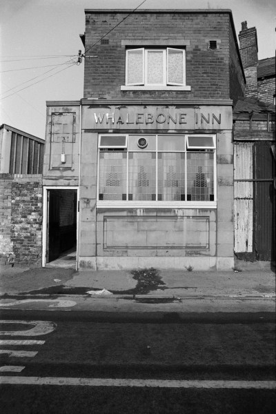
36g24: Whalebone Inn, Lincoln St entrance, 1983 – River Hull
You can see the new pictures added each day at Hull Photos, and I post them with the short comments above on Facebook.
Comments and corrections to captions are welcome here or on Facebook.
Continue reading Hull Photos: 14/7/17-20/7/17
