Caledonian Road, Barnsbury & Lower Holloway – 1990

Caledonian Road, Barnsbury & Lower Holloway continues my walk which began at Kings Cross on Sunday February 11th 1990 with the Kings Cross and Pentonville 1990. The previous post to this was Battlebridge, Canalside and Barnsbury – 1990.

Used furniture, Caledonian Rd, Barnsbury, Islington, 1990, 90-2c-54

From Thornhill Square I returned along Bridgeman Road to Caledonian Road, both sides of which are here lined with shops. Almost immediately on the east side of the road I saw this shop selling used furniture (I think it is now an estate agents) with the pavement in front having some of its stock – stacking tubular chairs – in front of a crude partition, at its left a phone card box and in front of that some cabinets used to support the shop’s sign.

The pavements along here are now cleared of clutter.

Sandwich Bar, Fire Escape Specialists, Caledonian Rd, Barnsbury, Islington, 1990, 90-2c-56

R Bleasdale & Co Ltd, Fire Escape Specialists had a splendid gate advertising their Victorian Metal Design. This was at 394 Caledonian Road where a similar business, The Cast Iron Shop, remained until around 2020, though the gate was long gone, together with the Sandwich Bar.

The sandwich shop also interested me with it with its striped awning and notices, incluind ‘DELICIOUS HOT SALT BEEF’ though I was unable to try it as like most shops then it was closed on Sundays.

Chinese Chef, Restaurant, Caledonian Rd, Lower Holloway, Islington, 1990, 90-2c-42

Another window I found of interest, divided into two halgs one of much had four shleves each with two spider plants and above them a net curtain. The left half mixes the reflection of the buildings opposite with the menu, a light fitting, plants and cans of soft drink under a counter inside.

Chinese Chef was on the corner with Roman Way until around 2019

Romeo Trading Co Ltd, Roman Way, Lower Holloway, Islington, 1990, 90-2c-44

I walked a few yards down Roman Way to photograph Romeo Trading Co Ltd, making several pictures both in black and white and in colour. I think this is the company founded in 1941 specialising in military surplus clothing and now operating online and in “an impressive 85,000 square foot warehouse“, Romeo House, in Tottenham.

Their former site and more of the street is now occupied by a large block of flats, Roman Court.

Mallet Porter & Dowd, Caledonian Rd, Lower Holloway, Islington, 1990, 90-2c-45

From Roman Way I photographerd Mallet Porter & Dowd on the west side of Caldedonina Road at 465 made hard-wearing fabric from horse-hair at their premises close to the Metropolitan Cattle Market, used for uniforms and textile products. This building inscribed with their name dates from 1874.

It was disgracefully converted into student housing for University College London by Mortar Developments in 2015, in a development that retained the facade a few feet in front of an unsympathetic modern development to the detriment of both. It was a worthy winner of the 2013 v awarded by Building Design for the year’s worst building. Islington Council had rejected the scheme but this was overturned on appeal.

Salvo, Caledonian Rd, Lower Holloway, Islington, 1990, 90-2c-46

Salvo C F S Ltd, Wine & Provision Importers occupied the building immediately south of Mallet Porter & Dowd until it was demolished around 2011. The company was set up by Salvatore Cumbo who owned a pizzeria in London to import Italian food and drink as wholesalers. The company moved here in 1975, and moved out in 2011 to larger premises in Hertfordshire.

The doorway between the two buildings had the number 465 and so was to the Mallet Porter & Dowd building; the free-standing ‘facade’ rather oddly retains its right hand edge of this door. It perhaps led to the offices and the building also had the wider doorway at the right of the picture.

At this point I think I decided to take a little rest and got on the tube. I’d planned to get to Finsbury Park and time was running out. The next in this series of posts will begin with tthe next frame I made which was in Finsbury Park.


FlickrFacebookMy London DiaryHull PhotosLea ValleyParis
London’s Industrial HeritageLondon Photos

All photographs on this page are copyright © Peter Marshall.
Contact me to buy prints or licence to reproduce.


North and South – London, May 1994

North and South – London: In May 1994 I was mainly photographing around Enfield, the most northerly of London Boroughs, but in the middle of one film there are a few pictures from Morden, the southern end of the Northern Line. I can’t remember why I made the trip there, possibly on a visit to a friends or perhaps on a family outing to Morden Park on the River Wandle.

Chimes, pub, 510, Hertford Road, Enfield Wash, Enfield, 1994, 94-05-1-26

This pub or club seems to have had an unusually large number of changes over the years and was also at various times Club X Zone’, Bar FM’, ‘Bell’, ‘Hotshots’, ‘Texas Cantina’, and more. Now a restaurant.

Shop Window, Bush Hill Park, Enfield, 1994, 94-52-61

A strange assortment of clothing on some rather odd two dimensional figures of women with holds in their heads and a line of children’s toys at the bottom of the window.

The Flower Box, Bush Hill Park, Enfield, 1994, 94-52-62

A colourful building though I was sad that parts of the mural below the windows was was obscured by almost empty display stands, one made from milk crates.

The Flower Box, Bush Hill Park, Enfield, 1994, 94-52-65

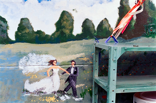
A small section of the mural from the previous picture shows a wedding couple striding across the fields.

Shops, London Rd, Morden, Merton, 1994, 94-52-44

A fairly typical suburban shopping street with a Boots, Abbey National, Holland & Barrett and at right ‘A NEW FORCE ON THE HIGH STREET’ which I’ve never heard of. The sun is clearly shining but there are ominous clouds above.

Merton Civic Centre, London Rd, Morden, Merton, 1994, 94-52-46

These buildings are still there on the corner of London Road and Crown Lane close to Morden Underground Station and are still Merton’s Civic Centre.

Shops, Merton Civic Centre, Crown Rd, Crown Lane, Morden, Merton, 1994, 94-52-32

The Civic centre is in a triangle of land surrounded by busy roads. This view seems now largely unchanged except for the names of the shops.

Morden Court Parade, London Rd, Morden, Merton, 1994, 94-52-34

Morden Court Parade is still there a little to the south on London Road from the Civic Centre and looks in rather better condition now. But sadly those 1930s windows have been replaced by fatter plastic double glazing which although greatly more comfortable for the residents both for keeping warm and reducing traffic noise from busy A24 dual carriageway rather spoil the appearance of the building. There are also some new balconies which fit in fairly well with the building and although it has lost than ‘MORDEN COURT PARADE’ from the frontage it has been replaced rather larger on the roof.

Back to North London in my next post from 1994.


FlickrFacebookMy London DiaryHull PhotosLea ValleyParis
London’s Industrial HeritageLondon Photos

All photographs on this page are copyright © Peter Marshall.
Contact me to buy prints or licence to reproduce.


Stamford Brook, Ravenscourt Park and a Bull – 1990

Stamford Brook, Ravenscourt Park and a Bull: My photographs on Sunday 7th January 1990 began with a couple of views of the Thames though the window of my District Line train which I’ve not put online, but my walk started after I got off at Stamford Brook station and walked south down Goldhawk Rd.

Goldhawk Rd, Stamford Brook, Hammersmith & Fulham, 1990, 90-1d-63

This fine house at 397-399 attracted my attention. It had been Grade II listed in 1976, but the listing text was unusually vague about its date, calling it “Early to mid C19” and the Westcroft Square conservation area document is equally vague.

Beyond the house is a large noticeboard for ‘Z GREGORY BROTHERS, BUILDING CONTRACTORS’ at 399a, still there and I think only the phone number has changed, and another fairly grand semi-detached house which I think are late Victorian.

St Peter's Square, Hammersmith, Hammersmith & Fulham, 1990, 90-1d-53
St Peter’s Square, Hammersmith, Hammersmith & Fulham, 1990, 90-1d-53

Since I was so close I couldn’t resist another short visit to St Peter’s Square south of the main road which changes its name here from Chiswick High Road to King Street. After the county of London was formed in 1889 this was the boundary between London and Middlesex and it is now the boundary between the London boroughs of Hounslow and Hammersmith & Fulham.

I’d photographed this square fairly extensively the previous month – see my post here) and only stopped to take a handful of pictures – this the only one online – and I was rather pleased with it.

Youngs Corner, Goldhawk Rd, King St, Stamford Brook, Hammersmith & Fulham, 1990, 90-1d-55
Young’s Corner, Goldhawk Rd, King St, Stamford Brook, Hammersmith & Fulham, 1990, 90-1d-55

Back on the main road I photographed the corner of Goldhawk Road and King Street, known as Young’s Corner and, as a plaque at first floor level also informs us, ‘REBUILT 1894’, though I’m rather surprised the architect wanted his name on the rather drab two storey buildingon the corner. But at least it doesn’t completely hide the much grander Victorian building at 417 Goldhawk behind behind with its slim turret – and it is perhaps this building for which the architect was claiming credit rather than the shop.

Grocer John Young had leased a shop here in 1830, and it later also became a post office. When at his death in 1860 his youngest son Charles Spencer Young took over the business he eventually turned it into a shop to display prints as a successful picture dealer. When horse-drawn trams ran to here in 1882, the tramway stop was named Young’s Corner.

King St, Stamford Brook, Hammersmith & Fulham, 1990, 90-1d-56

A fine row of three shops at 352- 356 King Street. At left is a basic and rather ugly more modern building – described in the conservation area document as “modern infill of no merit and bulky appearance“.

Ravenscourt Park, 1990, 90-1d-45
Ravenscourt Park, Hammersmith & Fulham, 1990, 90-1d-45

Ravenscourt Park is not just an Underground station, but a decent sized park with a lake fed by Stamford Brook, which originally was part of a moat around the manor house of Palingswick (or Paddenswick) Manor. It and the area got its name after the house was bought in 1747 by Thomas Corbett who renamed it Ravenscourt, thought to be a not very good pun on his name – ‘corbeau‘ being French for raven.

I hardly went into the park, and this house is 260 King Street.

Mac's Cameras, Shops, 250-8, King St, Hammersmith & Fulham, 1990, 90-1d-46
Mac’s Cameras, Shops, 250-8, King St, Hammersmith & Fulham, 1990, 90-1d-46

The house at 260 King Street is at the left of this picture, followed by a row of shops including one of more interest to me than most, Mac’s Cameras. Max Irming-Geissler set up the shop here in the late 1950s and it continued more or less until his death in 2012. It was a great place to look at a window full of second-hand cameras and lenses, though I don’t think I ever actually bought anything there.

The Bull, Ravenscourt Arms, King St, Hammersmith, Hammersmith & Fulham, 1990, 90-1d-31

This Grade II listed black bull was created by Obadiah Pulham of Pulham & Son in Woodbridge, Suffolk, a well-known maker of garden ornaments, grottoes and follies. It is almost certainly made from Pulhamite, their own proprietary artificial rock, similar to the better-known Coade stone. I think it might actually have been William Lockwood’s Portland Stone Cement. James Pulham was an apprentice to Lockwood and became manager of Lockwood’s Spitalfields office around 1820 with his brother Obidiah as his assistant.

It was created as a pub sign for the Black Bull coaching inn at 122a Holborn and gets a mention from Dickens in Martin Chuzzlewit published in 1843. The pub was demolished in 1904 for an extension to Gamages but the bull was saved by Hammersmith MP Sir William Bull to put above the entrance to his law firm in King Street.

When these offices were demolished it was located outside a 1960s pub, at 257 King Street, a short way down Vencourt Place. The pub later changed its name from the Ravenscourt Arms to the Black Bull. The pub closed around 2018 but it and the bull are I think still there.

More from Hammersmith to follow.


FlickrFacebookMy London DiaryHull PhotosLea ValleyParis
London’s Industrial HeritageLondon Photos

All photographs on this page are copyright © Peter Marshall.
Contact me to buy prints or licence to reproduce.


West India Dock Road & Limehouse Cut – 1990

West India Dock Road & Limehouse Cut: My walk in Limehouse on Sunday 6th January 1990 continued. The previous post from this walk is Garford Street Limehouse – 1990. As usual you can click on the images here (except the panorama) to view larger versions on my Flickr pages.

Shops, West India Dock Road, Limehouse, Tower Hamlets, 1990, 90-1c-42

This area is close to the parish border of Limehouse and Poplar, but in popular imagination was certainly Limehouse, London’s first ‘Chinatown’. But by 1990 Chinatown had almost entirely moved to Soho, though a few elements remained, including the Peking Restaurant – though a few shops down the street is the Poplar Fish Bar.

Davey & Co, 88, West India Dock Road, Limehouse, Tower Hamlets, 1990, 90-1c-43

“In February 1885 Arthur Christopher Davey began a venture that throughout the 20th century evolved into a culture in the manufacture and supply of marine equipment. From humble beginnings in Leadenhall Street, the company soon moved to its famous address at 88, West India Dock Road, London E14, where it successfully traded for over 100 years.” The company is now based in Colchester.

Shops, West India Dock Road, Limehouse, Tower Hamlets, 1990, 90-1c-45

The Wah Ying Restaurant was another remanant of Chinatown – and you can see along the road the sign of the Peking Restaurant. In the distance are the warehouses of the West India Docks and beyond them the cranes building Cabot Square at Canary Wharf.

West India Dock Road was laid out at the same time as the West India Docks opened in 1802, a new road to give access to them, which was for many years a toll road. I think these buildings probably date from the 1870s or a little later after the tolls were removed.

The restaurant looks very much closed and the broken windows above suggest it was empty and derelict when I made this picture.

Blockage, Limehouse Cut, Limehouse, Tower Hamlets, 1990, 90-1c-46

The Limehouse Cut runs on a straight route through Poplar but curves around at its southern end. It was blocked here in 1990, possibly in connection with the building of the Limehouse Link tunnel between 1989 and 1993. But there was also work on the Cut around then, with the vertical guillotine gate on the north side of Britannia Bridge across the Commercial Road being removed.

Poplar Mods, graffiti, Railway Viaduct, St Anne's Church, Limehouse, Tower Hamlets, 1990, 90-1c-32
Poplar Mods, graffiti, Railway Viaduct, St Anne’s Church, Limehouse, Tower Hamlets, 1990, 90-1c-32

The tower of Hawksmoor’s St Annes Limeouse seen above the viaduct built for the London and Blackwall Railway and opened in July 1840, the second or third railway viaduct to be built in London, after the 1836 London to Greenwich viaduct and the the Hanwell viaduct, technically then outside London. The line went to Brunswick Wharf in Blackwall where passengers could board ferries and boats to other destinations down river or around the world.

I can tell you nothing more about Poplar Mods except that the graffiti tells us they are male “Hammers” fans. West Ham began life as a team for the workers of the last remaining shipbuilders in the area not far away on Bow Creek as the Thames Ironworks Football Club. From 1895 they played at Hermit Road in Canning Town, former home to Old Castle Swifts, Essex’s first professional team which had gone bankrupt, They became West Ham United in 1900 and moved to Plaistow, before in 2004 uniting with the Boleyn Castle football club and moving to their Upton Park ground where they stayed until 2016.

Limehouse Cut, Railway viaduct, Limehouse, Tower Hamlets, 1990, 90-1c-21

I think the next few pictures I made were taken from the block of flats immediately to the east of Limehouse Cut, Kiln Court, a medium rise block built as part of the Barley Mow Estate for the GLC in 1965-8. Back in 1990 many blocks still did not have security doors and it was possible to easily access shared areas.

Here you can see the Cut and the DLR viaduct across the north side of Limehouse Dock with its bridge and the Roman Catholic Church of Our Lady Immaculate & St Frederick on the corner of Island Row and Commercial Road.

I think the buildings on the far bank of Limehouse Cut were temporary offices and accommodation for the building of the Limehouse Link tunnel. The site is now occupied by housing at the end of Island Row.

Limehouse Cut, Limehouse Dock, Railway viaduct, Limehouse, Tower Hamlets, 1990, 90-1c-23

In this picture you can see across to Limehouse Dock with the Hydraulic Accumulator Tower next to the DLR viaduct at the right. At the left is the temporary blockage on the Limehouse Link.

Limehouse Cut, Limehouse Dock, Railway viaduct, Limehouse, Tower Hamlets, 1990, 90-1c-24

Sliding my shift lens to the left gave a view a little further towards the south and shows a little more of the Cut past the blockage and in the distance a small glimpse of the River Thames. This image was taken to create a panorama together with 90-1c-23:

Limehouse Cut, Limehouse Dock, Railway viaduct, Limehouse, Tower Hamlets, 1990, 90-1c-23-24

More from Limehouse Cut in the next post on this walk.


FlickrFacebookMy London DiaryHull PhotosLea ValleyParis
London’s Industrial HeritageLondon Photos

All photographs on this page are copyright © Peter Marshall.
Contact me to buy prints or licence to reproduce.


Crouch End & Upper Holloway – 1989

The final post on my walk on Sunday 19th November 1989 which had begun in Highgate. You can read the previous part at A Reservoir, Flats, a Cockerel and a Café.

Gateway, Albert Mansions, Crouch Hill, Crouch End, Islington, Haringey, 1989 89-11i-61
Gateway, Albert Mansions, Crouch Hill, Crouch End, Haringey, 1989 89-11i-61

I walked down Haslemere Road and then turned down Vicarage Path, following this to Crouch Hill.

Albert Mansions, described by various estate agents as “a hidden gem in Crouch Hill” dates from 1903. Although the driveway is clearly marked ‘PRIVATE residents only‘, Vicarage Path goes past the building and emerges at the side of the left gatepost in my photograph. I clearly found this gateway more interesting than the actual mansion building where three and four bedroom leashold flats now sell for approaching a million.

House, Heathville Rd, Highcroft Rd, Crouch End, Islington, 1989 89-11i-64
House, Heathville Rd, 6, Highcroft Rd, Crouch End, Islington, 1989 89-11i-64

I walked down Crouch Hill and turned west down Ashley Rd. When I reached Highcroft Road I saw an interesting roof a short distance down and walked up to take this picture. Taken from just across the street it rather fails to show clearly the pyramidal cap to the roof, which is more evident in the previous frame (not on-line) taken of the row along this side of the street. But does give a good idea of the architectural detailing, including a fancily written date which I can’t quite read but is perhaps 1897 or 9 and a rather striking head – I wondered who was the model for this intense face. I’m rather suprised that this building does not appear to be locally listed

House, Highcroft Rd, Crouch End, Islington, 1989 89-11i-65

This locally listed house at 3 Highcroft Road was built in 1875 as the vicarage to St Mary’s Church opposite, and has rather fine porch with a somewhat ecclesiastical look. Like many of the large vicarages provided for Victorian clerics who were expected to have large families and servants I imagine it was sold off some years before I made the picture.

Houses, Hornsey Rise, Upper Holloway, Islington, 1989 89-11i-66

I returned to Ashley Road, walking past St Mary’s church without photographing it. Most of our Anglican churches seem to have been photographed time after time from the Victorian period on, not least because many vicars with time on their hands took up photography as a hobby. I seldom chose to add to the multitude.

There is a line of similar fine houses between Ashley Road and Shaftestbury Road, at 2-20 facing Elthorne Park, but I chose to photograph these because of the wall with its sculptures and irorwork in front of what I think was 6 Hornsey Rise. The wall and ironwork are still there but the figures next to the pavement have long gone. At the right of the picture you can see the Shaftesbury Tavern.

House, Hornsey Rise, Upper Holloway, Islington, 1989 89-11i-53

Hornsey Rise was developed from 1848, although it only got the name almost 40 years later replaceing the different names of various short lengths such as this. This picture gives a closer view of one of the two ornamental gates and the house , with the doorway to number 4 at the right of the image.

The Shaftesbury Tavern, Shaftesbury Rd, Hornsey Rise, Upper Holloway, Islington, 1989 89-11i-54

This pub at 534 is the last building on Hornsey Road, which becomes Hornsey Rise beyond Shaftesbury Rd. According to its local listing it “was built in 1858, by speculative builder Thomas Beall, as the area around it began to be developed. It is a handsome well-preserved building with contrasting brickwork in red and London stock, and pilasters and arches at the upper storey level.

I choose to photograph not the main pub building but its “1897 addition” on Shaftesbury Rd. However CAMRA states that the pub itself was built “in 1897 with rich wood and glasswork, so typical of the golden age of pub-building.” Looking at the pub exterior I am inclined to believe them and the current building probably replaced or significantly altered Beall’s. As they also state, “The pub was restored in 2014 from a ‘very tired’ state by the small pub chain Remarkable Restaurants Ltd“.

Shops, Fairbridge Rd, Hornsey Rd, Upper Holloway, Islington, 1989 89-11i-55

I continued walking down Hornsey Road I photographed this handsome late Victorian building at 471 Hornsey Rd on the corner with Fairbridge Road. Then it was a timber merchant with T C TIMBER on the first floor corner blind window and a rather jaunty-looking painted figure of a town crier in ancient dress looking like a poor piece of advertising clip-art in that above it on the second floor. The shop is now Hornsey Carpets and that figure now looks very washed out and on the first floor is some strange image I make no sense of.

Kokayi, Supplementary School, Hanley Rd, Upper Holloway, Islington, 1989 89-11i-56

Further down Hornsey Road I went down Hanley Road where I photographed the doorway of the Kokayi Supplementary School. A charity of this name was later registered in 1997 “To advance the education of children and young people particularly children and young people of African and Afro-Caribbean descent by the provision of a supplementary school: By the provision of advice and guidance in matters concerning their education and career development; And by such other charitable ways as the charity through its trustees may from time to time decide.” The charity was removed in 2014 as it had ceased to function.

I was at the end of my walk and made my way to Finsbury Park Station. It was several weeks before I was able to go out and take photographs again.


FlickrFacebookMy London DiaryHull PhotosLea ValleyParis
London’s Industrial HeritageLondon Photos

All photographs on this page are copyright © Peter Marshall.
Contact me to buy prints or licence to reproduce.


Almshouses, Museum, Hospital & Shops – Highgate 1989

Almshouses, Museum, Hospital & Shops – Highgate: More from my walk in Highgate on Sunday 19th November. You can read the previous part at Into Highgate Village.

Wollaston and Pauncefort, Almshouses, Southwood Lane, Highgate, Haringey, 1989 89-11f-12

The Wollaston and Pauncefort Almshouses were set up by wealthy City goldsmith Sir John Wollaston who was Lord Mayor of London in 1643 and a among many other positions was a Governor of Highgate School and briefly Lord of the manor of Hornsey. In his last years he had these almshouses built for “six men and women of honest life and conversation‘ from Hornsey and Highgate, and his will in 1658 made the governors of Highgate school trustees of the almshouse.

His endowment provided those living in the almshouses an income of 50 shillings a year and for money for the repair of the premises. The school governors selected the residents and laid down strict rules for them, including attending services in the school chapel.

However by 1722 the building was beyond repair and school governor and treasurer Edward Pauncefort had them rebuilt, doubling the number of residents to 12 and adding a charity school for girls. His endowment and other bequests also gave the residents a rise to £7 a year.

The Grade II listed almshouses were altered internally over the years and finally the year before I made this picture significantly modernised and provided with indoor bathrooms and toilets by merging pairs of the units, reducing the number of residents to the original six. Only one of each pair of doors is now in use.

My picture includes a phantom cyclist, blurred almost to extinction by the slow shutter speed I used.

Highgate School Museum, Southwood Lane, Highgate, Haringey, 1989 89-11f-13
Highgate School Library, Southwood Lane, Highgate, Haringey, 1989 89-11f-13

The Highgate Tabernacle at 20a Southwood Lane was built as a Baptist chapel in 1836, replacing an earlier Presbyterian chapel and was Grade II listed in 1974. In 1976 the chapel was bought by Highgate School and served as their library for almost 30 years. It now houses the archive and museum of the school, open to researchers and occasionally to the public.

Among its holdings are the “Royal Charters of Queen Elizabeth I, authorising our founder Sir Roger Cholmeley to found a school at Highgate, 29 January 1565, 6 April 1565“.

Southwood Hospital, 70, Southwood Lane, Highgate, Haringey, 1989 89-11g-53

The Limes was built in 1815 and in 1921 was bought for use as an orphanage by the Furniture Trades’ Provident and Benevolent Institution who renamed it Radlett House. In 1940 they moved to larger premises and leased the property to Middlesex County Council who converted it to a small hospital. After becoming a part of the NHS it was renamed Southwood Hospital.

Southwood Hospital, 70, Southwood Lane, Highgate, Haringey, 1989 89-11g-54

The hospital was still in use though on a reduced scale when I made these two pictures, but a notice beside the main entrance (part visible on my first picture) makes clear it offered no casualty or accident and emergency services. It simply housed a few beds for chronically ill patients needing nursing care.

The hospital closed in 1991 and in 2004 was was converted into a terrace of large private houses.

Shops, 164-198, Archway Rd, Highgate, Haringey, 1989 89-11g-45

Archway Road was designed in 1808 as the world’s first bypass to provide a less steep route out of London than Highgate Hill for heavy waggons by building a 900ft long tunnel. Work started in 1810 but unfortunately the tunnel collapsed in 1812 when it was almost finished. Fortunately nobody was killed but it was decided to convert the tunnel into a cutting. This then needed a bridge to carry Hornsey Lane over the new road, and John Nash came up with an elegant brick design with a tall narrow arch for traffic and above that a three arch bridge carrying the road.

But the arch was too narrow as traffic increased and was replaced with the current bridge in 1900. This row of shops begin around 200 metres north of the bridge.

Shops, 164-198, Archway Rd, Highgate, Haringey, 1989 89-11g-33

Steps lead up from Archway Road to Winchester Road from where I was able to make this second picture of the long row of shops. The conservation area appraisal describes this as late Victorian and “very distinctive with original balustrades above many of the shops” and notes the “top floor balconies set back under large arches with half timbering” and the “very eye-catching” roofscape though it notes only some of the stone finials have survived. These details are clearer in the previous picture.

Still more from Highate to come in a later post.


FlickrFacebookMy London DiaryHull PhotosLea ValleyParis
London’s Industrial HeritageLondon Photos

All photographs on this page are copyright © Peter Marshall.
Contact me to buy prints or licence to reproduce.


Yet More from Stoke Newington

Yet More from Stoke Newington: This is the final post about my walk on 8th October 1989 going down Stoke Newington High St towards Dalston with some minor detours. The previous post on this walk was Cemetery, Synagogue & Snooker.

Shops, 77, Stoke Newington High St, Stoke Newington, Hackney, 1989 89-10f-52

I wondered about the history of these three shops at 75-79 Stoke Newington History with the three-story Golden House Chinese takeaway at its centre. The first-floor brickwork on either side didn’t quite seem to match suggesting to me that the central building may have been a post-war addition to an existing building, or that these first floors may have been a later addition.

This central shop is still a Chinese takeaway but under a different name.

Hovis Bread, Batley Rd, Stoke Newington High St, Stoke Newington, Hackney, 1989, 89-10f-55
Hovis Bread, Victorian Grove, Stoke Newington High St, Stoke Newington, Hackney, 1989 89-10f-55

The Cinema Treasures site states that The Vogue Cinema at 38 Stoke Newington High St opened as The Majestic Electric Palace on 15th December 1910 and was closed on 21st June 1958 as a protest by Classic Cinemas against the landlord’s rent rise.

It remained shuttered and closed for 42 years until in November 2000 the foyer was converted into a Turkish restuarant with housing behind, described to me on Flickr as the “best Turkish restaurant ever.” The restaurant owners restored the Vogue sign.

My picture with the Hovis Bread ghost sign was taken from a few yards down Victorian Grove looking towards the cinema across the High Street. The block at right of the picture has now been replaced by a large building with a Tesco Extra on its ground floor.

House,  Victorian Grove, Stoke Newington, Hackney, 1989 89-10f-56
House, Victorian Grove, Stoke Newington, Hackney, 1989 89-10f-56

This street was originally called Victoria Grove, but its name was changed some time in the middle of the last century. Much of the area was redeveloped in the 1970s but these houses dating from the early years of Victoria’s reign in the 1840s or 1850s remain.

This Grade II listed pair with the unusual curved bays and balconies have the name ‘BRIGHTON VILLAS’ on a plaque between the first floor windows, hidden by the curvature of the nearer bay in my photograph. The nearer balcony roof has been replaced since I took this, matching the one on its neighbour.

Works entrance, Victorian Grove, Stoke Newington, Hackney, 1989 89-10f-41

The wall beside 3 Victorian Grove is still there, but now has only graffiti on it. There are still some industrial units behind the villas of Victorian Grove, though surely they will soon be replaced by expensive flats, but access to these is now thourgh a gated vehicle entrance further down the street.

Posters, Stoke Newington High St, Stoke Newington, Hackney, 1989  89-10f-42
Posters, Stoke Newington High St, Stoke Newington, Hackney, 1989 89-10f-42

Should you Google – as I did – ‘Trevor Moneville‘ – you will find he was a 33-year-old from Hackney, was found dead at HMP Lewes on April 18, 2021 from Sudden Death in Epilepsy (SUDEP) because of insufficient and unacceptable management of his care.

But this was a case of history repeating itself. A copy of the poster at top right is also in the collection of Hackney Museum, where the web site notes:

“Trevor Monerville went missing from Stoke Newington police station after being taken into custody on New Year’s Eve, reappearing after several days on the other side of London in Brixton prison. He had multiple injuries and later underwent emergency surgery in Maudsley Hospital. The case highlighted existing concerns about alleged institutional racism in the Metropolitan Police and led to the formation of the Hackney Community Defence Association in 1988.”

And in the centre of the picture is a poster for another, better known case of police brutality. Blair Peach was a young teacher murdered by the police Special Patrol Group who went beserk when policing an anti-racist protest in Southall on 23 April 1979.

Andy's Fashions, 141, Stoke Newington Rd, Stoke Newington, Hackney, 1989 89-10f-43
Andy’s Fashions, 141, Stoke Newington Rd, Stoke Newington, Hackney, 1989 89-10f-43

Further south Stoke Newington High Street becomes Stoke Newington Road, and back in 1989 I found myself confusing the two. Andy’s Fashions was at 141 Stoke Newington Road. No longer Andy’s, the shop is now Stitch “N” Time offering tailoring, alterations, repairs. and no longer has its wares on the pavement outside or partly blocking the entry to the Stoke Newington Estate of the Industrial Dwellings Society (1885) Ltd.

The IDS was established as the Four Per Cent Dwellings Company in 1885 by “Jewish philanthropists to relieve the overcrowding in homes in the East End of London” and changed its name in 1952. They opened the Stoke Newington Estate in 1903.

Curtains,  Stoke Newington Rd, Stoke Newington, Hackney, 1989 89-10f-32
Curtains, Stoke Newington Rd, Stoke Newington, Hackney, 1989 89-10f-32

Another shop somewhere on Stoke Newington Road, with a fine formation of net curtains for sale, though in my book ‘1989’ I imagined them rather differently, perhaps as the front of a vast army of angels, “Or a phalanx of klansmen or some strange voodoo creatures about to burst out onto the streets of London.

The book is still available on Blurb, though at a silly price for the print version, but you can see over half of it on the preview there or the full set of pages on the web site where this image and its text is on page 19.

The texts in that book were intended to explore the question of why some scenes grabbed my attention enough to make me fix them as photographs, and why they continue to excite my imagination and I hope that of other viewers.

Street Market, Shoreditch High St, Tower Hamlets, Hackney, 1989 89-10f-33

My walk had ended and I got on the bus to take me to Waterloo for the train home. I almost always sit on the upper deck on double-decker buses and enjoy the views from the windows. As the bus went slowly along Shoreditch High Street close to the junction with Commercial Street it passed the informal market on the pavement where I had time to take three frames through the window. The area looks a little different now, but the last time I went past on a Sunday there was still a rather similar market there.

This is the final post about my walk on 8th October 1989. You can find more pictures from London and elsewhere on Flickr, with both black and white and colour images in albums mainly arranged by the year I took them, such as 1989 London Photos and 1989 London Colour.


FlickrFacebookMy London DiaryHull PhotosLea ValleyParis
London’s Industrial HeritageLondon Photos

All photographs on this page are copyright © Peter Marshall.
Contact me to buy prints or licence to reproduce.


Ninety from Narbeth, Pembrokeshire:

Ninety from Narbeth: Narberth (Arbeth to Welsh speakers) was until recently a place I had never hear of, a small town in Pembrokeshire with ancient origins. I spent a week staying there with a small group of friends at the start of September 2024, returning last Saturday.

Ninety from Narbeth

Narbeth apparently grew up around the palace of a Welsh king and in the great collection of ancient Welsh stories preserved by oral tradition until first written down around 1350, the Mabinogion, is the chief palace of Pwyll, Prince of Dyfed. There were ancient camps nearby and the Romans came – and went.

Ninety from Narbeth

But it was the Normans who, having invaded England in 1066, a few years later turned their attention to Wales and left a great mark on the area, building more than 50 massive castles to invade and occupy the area. Thee wars here were a complex and changing situation and other castles were built by the Welsh to defend their land.

Ninety from Narbeth

A castle was first built at Narbeth by the Normans around 1116, but rebuilt in stone in the following century. It formed a part of what is now called the Landsker Line, defending the territory they controlled against the Welsh. The castle is now in ruins but open to the public, though the buildings are fenced off for safety reasons.

Ninety from Narbeth

The Landsker Line divided the largely English-speaking area of south Pembrokeshire, dominated by the Normans from Welsh-speaking Wales, and the area to the south of it was often called ‘Little England’.

Now only around a fifth of the roughly four thousand residents of Narberth are Welsh-speaking. For a town of its size it has a remarkable number of independent shops and particularly at weekends the place is crowded. Ten years ago The Guardian called it “a gastronomic hub for West Wales” and named it as “one of the liveliest, most likeable little towns in the UK.

I can’t comment on the gastronomy, though I did help to cook some interesting meals for our small group staying there, but it does have a very fine shop making artisanal ice cream with some unusual flavours. And I only visited one of its many pubs, which was a very friendly place, though I just missed the live music there.

As well as more traditional shops, the town also has more than its share of arty shops and some with a hippy or ‘New Age’ vibe. And its certainly a very friendly place compared to suburban London and one of a number of locals we met in a pub shook my hand when I revealed one of my Grandmothers had come from Wales. I’m not surprised that Narberth was “named one of the best places to live in Wales in 2017

It has an excellent local museum and of course a number of churches and chapels, though some now in other uses. These are among its 70 listed buildings, most of which I think are in the pictures I took, though many of the more interesting are unlisted.

It isn’t far to drive to many other attractions of the area – more castles, mills, the rugged coastal path and more sedate seaside resorts with some fine beaches. Friends took me to some of these but there were many more.

Perhaps the most disappointing thing about Narberth is the railway station, around three-quarters of a mile from the centre of town. On the map the railway seems useful, but in reality there are too few trains to be of much use. The station building is now a joinery though Platform 1 (and only) still stands, with an announcement telling us that this was a request stop, and we should indicate clearly to the driver as the train approached that we wanted to board. Fortunately it did stop when we began our journey home.

All the pictures here are from Narberth town centre, and there are more on Facebook in the album ‘Ninety From Narbeth‘. I’ll make some later posts about some of the places in the area we were able to visit during our holiday.


FlickrFacebookMy London DiaryHull PhotosLea ValleyParis
London’s Industrial HeritageLondon Photos

All photographs on this page are copyright © Peter Marshall.
Contact me to buy prints or licence to reproduce.


Stoke Newington Shops – 1989

Stoke Newington Shops: Continuing my walk on Sunday 8th October 1989 which had begun at Seven Sisters Station from where I had walked south down the High Road and the previous post, Church of the Good Shepherd, Synagogue & Stamford Hill had ended on Stamford Hill.

Star Mews, Cafe, Windus Rd,  Stoke Newington, Hackney, 1989 89-10d-15
Star Mews, Cafe, Windus Rd, Stoke Newington, Hackney, 1989 89-10d-15

I continued walking down Stamford Hill, taking a brief look down each side street, but nothing particularly attracted my attention until I reached Windus Road. Some way down this I came to the entrance to Star Mews.

The archway to Star Mews is still there between 52 and 54 Windus Road but there is no longer a cafe, the property is now residential with a small walled front garden. Star Mews is one of two mews in the street and leads to two single storey (now with roof windows) in the area behind which were presumably once stables.

The houses here are not grand, and I think these were probably built for small businesses who will have had horse-drawn carts for delivery rather than the carriages of mews in grander districts.

Shops, Willow Cottages, Stoke Newington, Hackney, 1989 89-10d-16

I went back to Stamford Hill and at the entrance to Stoke Newington Station turned into a small pedestrian side-street, Willow Cottages with this row of three shops, one of them Marshall’s School of Motoring so had to take this picture. These are still there beside the new station building, and G’s Car Service is now Ron’s Car Service. – the old station was almost invisible at street level – but this small area has altered so much I can’t be sure. The jewellers is now a hair salon and Marshalls have left the building, now occupied by Ria money transfer and a takeaway.

Shops,  Manor Rd, Stoke Newington, Hackney, 1989 89-10e-62
Shops, Manor Rd, Stoke Newington, Hackney, 1989 89-10e-62

I crossed the busy A10 Stamford Hill and went down Manor Road opposite where there was this row of shops on the north side. These three shops are single storey buildings, at the end of the two storey buildings of Manor Parade, but seem to have been built in the same style, probably like their larger neighbours in 1906, according to an ornamental date on their gable.

The site with two large advertising hoardings at right is on the side of the railway line, here in a cutting, and there is be little level land behind these shops.

Stoke Newington Shops
Notices, Manor Rd, Stoke Newington, Hackney, 1989 89-10e-63

This noticeboard without notices on the top of what was until fairly recently a private hire service office, Hill Cars, is another of the pictures which I used in my web site, exhibition and self-published book ‘1989’, ISBN: 978-1-909363-01-4, still available, and this picture is from those. The first paragraph refers to the page before this one in ‘1989’.

Andora, Builders Merchants, House, 16, Manor Rd, Stoke Newington, Hackney, 1989 89-10e-64

The house here is still at 16 Manor Road and is now residential and without the clutter and signage. Andora’s builders yard is now commercial premises on the ground floor with flats above and a vehicle entrance to more in the yard behind.

L T Locking, Estate Agent, 18a, Manor Rd, Stoke Newington, Hackney, 1989 89-10e-65
L T Locking, Estate Agent, 18, Manor Rd, Stoke Newington, Hackney, 1989 89-10e-65

This short row of shops was just beyond the builders yard, all at 18 Manor Road, although they seem to have been built at different times. Locking’s estate agency is in a taller and more elegant four storey tower, and the closer building at right was, according to a ghost sign under its first and second floor windows, the DEPOSITORIES of T HARRIS, though his name is not clear. This industrial warehouse is now an events and filming venue and was the birthplace of the original TV “Dragons Den” where the first season was shot in 2005.

Lipman Bros, Builders, 20, Manor Rd, Stoke Newington, Hackney, 1989 89-10e-66
Lipman Bros, Builders, 18, Manor Rd, Stoke Newington, Hackney, 1989 89-10e-66

Also now I think a filming location as ‘The House Next Door‘ (or possibly a part of The Depository’ and that is the next shop.) Earlier it had been home to the curiously named Balloon Lagon (lagon is French for lagoon), which sold odd balloons and then a property agency.

The post at left looks like a lamp post, perhaps for a gas lamp, but could also have simply held an advertising sign. Srill on the pavement it has now lost its upper half.

Rabinowitz, Kosher Butcher, 2, Cazenove Rd, Stoke Newington, Hackney, 1989 89-10e-41

Back on the A10, I walked down to the end of Stamford Hill at Cazenove Road, where it becomes Stoke Newington High Street, and went briefly down Cazenove Road and photographed a couple of the shops there. I’d previously photographed Madame Lillie on a walk in July 1989 so haven’t digitised the picture I took this time, but this one of Rabinowitz, Kosher Butcher & Poulter and The Metaqphysical & Inspirational World Universal Book Shop at 2 and 4.

I returned to the main road and crossed it to the gates of Abney Park Cemetery where the next post on this walk will begin.


FlickrFacebookMy London DiaryHull PhotosLea ValleyParis
London’s Industrial HeritageLondon Photos

All photographs on this page are copyright © Peter Marshall.
Contact me to buy prints or licence to reproduce.


Highbury to Stoke Newington Church Street – 1989

Highbury to Stoke Newington Church Street: Continuing my walk from Sunday 1st October 1989 which had begun at Finsbury Park and continued to the Nags Head before returning to Finsbury Park. The previous post ended on Blackstock Road.

House, Kelross Rd, Northolme Rd, Highbury, Islington, 1989 89-10b-46
House, Kelross Rd, Northolme Rd, Highbury, Islington, 1989

Blackstock Road continues south into Highbury as Highbury Park and I walked some way down this before turning east into Northolme Road. Highbury Park was developed in the 1870s but the houses in Northholme Road date from the 1890s. This and neighbouring roads were built on the Holm Estate and the LCC applied for permission to develop these roads in 1890.

North Holme is near Helmsley, North Riding of Yorkshire and although it has been described as a “township” is a small cluster of buildings, more a farm than even a village close to the River Dove. “The Revd Joseph Parker, DD (1830-1902) … lived in 1866 at a house in Highbury Park he called ‘North Holme‘. The sites of Northolme Road, Sotheby Road and Ardilaun Road were on part of the grounds of his house.” He was the “Minister of the City Temple, 1869-1901, author, preacher and twice
Chairman of the Congregational Union
“.

This house is at the eastern end of Northolme Road, where it meets Kelross Road and is a detached villa rather larger than the terraces along long the rest of the road.

Clissold Park, Stoke Newington, Hackney, 1989 89-10b-35

From here Kelross passage leads to Highbury New Park, a street with villas built from around 1850. But I pressed on across it into Collins Road, making my way towards Clissold Park and Stoke Newington Church St.

Clissold House was built as Paradise House for Quaker City merchant Jonathan Hoare, a noted philanthropist and anti-slavery campaigner and brother of banker Samuel Hoare Jr. The water here was a stretch of the New River which brought clean drinking water from Hertfordshire to London, but I think at some point the river here was culverted, although the bridge taking Stoke Newington Church St across it remained until the 1930s.

The park was first created as grounds for this GradeII listed house. Hoare got into financial difficulties and lost the house and grounds, which passed through several owners before being owned by Augustus Clissold. When he died in 1882 the estate was bought by the Ecclesiastical Commissioners who intended to make money from developing it as housing, but the Metropolitan Board of Works were persuaded in 1887 to buy it to be a public park.

By 1989 the house and park were in a poor condition and Clissold House was put on English Heritages ‘at risk’ register in 1991. Since then both park and house have been restored with the aid of lottery money.

Park Crescent, Spensley Walk, Stoke Newington Church St, Stoke Newington, Hackney, 1989 89-10b-23

Grade II listed Park Crescent at 207-223 Stoke Newington Church Street was built in 1855, but by the 1980s was in a very dilapidated state and became home to around 90 squatters alongside only a handful of legal tenants. The houses were then owned by Hackey council who planned to sell them to housing associations.

Park Crescent, Spensley Walk, Stoke Newington Church St, Stoke Newington, Hackney, 1989  89-10b-11
Park Crescent, Spensley Walk, Stoke Newington Church St, Stoke Newington, Hackney, 1989 89-10b-11

Three motorbikes parked outside one of the houses of Park Crescent. You can clearly see the poor state of the buildings which need Acrow props to support the porches, with the steps at right being roped off to block access to the unsafe building.

Park Crescent now looks very neat and tidy compared to this.

Shops, 185-189, Stoke Newington Church St, Stoke Newington, Hackney, 1989 89-10c-51

The building at 185 Stoke Newington Church St had been sold when I made this picture in October 1989, but The Modern Man, a hairdressers, was still alive in another shop on the street, shown in my next picture.

This row of buildings with ground-floor shops is still there and like the rest of the area has become rather better kept and is now that epitome of gentrification, an estate agents which has also expanded into 187.

Perhaps surprisingly the 5 Star Cleaners at 189 is still a dry cleaners, though under a different name.

The Modern Man, Stoke Newington Church St, Stoke Newington, Hackney, 1989 89-10c-52

I found The Modern Man still in business at 121 Stoke Newington Church St at the corner with Marton Road. It didn’t survive the gentrification of the area and the shop has passed through several hands as ‘frere jacques’, ‘search and rescue, ‘Ooh Lou Lou Cakery’ and ‘The Caffeine Fix’.

I don’t know how long Tanya’s Cafe-Diner Take away lasted but around 2009 it became Lydia Cafe Restaurant and retained the name Lydia until recently becoming ‘The Tiffin Tin.’.

My walk was almost at an end, but I’ll share are few more pictures in a later post.


FlickrFacebookMy London DiaryHull PhotosLea ValleyParis
London’s Industrial HeritageLondon Photos

All photographs on this page are copyright © Peter Marshall.
Contact me to buy prints or licence to reproduce.