Lewisham, Black Heath and Heathside: Pictures from the final part of my walk on Sunday 18th March 1990. The previous post on this walk was Deptford, Greenwich and The Point – 1990.

I came down from The Point onto more or less the top of Point Hill, which rises steeply from Greenwich and turned east into West Grove where a few houses including this one overlook the western edge of the Black Heath – and a short distance across the grass the A2. Different maps show this section as the east section of Blackheath Hill or the start of Shooters Hill, though this section is more or less flat. There are a few trees in the grass which is criss-crossed by footpaths.
This Grade II* listed house, Manna Mead at 17 West Grove, was built around 1800. Although a fine building I think it owes its unusual Grade II* listing at least partly because of its position on the edge of Black Heath and its views. It is divided into flats.

I walked along to the well-known Rangers House on the edge of Greenwich Park and taking a few pictures there and on the way, including the listed Conduit Head for the water supply to the Greenwich Royal Hospital, none of which I have yet digitised. I went across the A2 and down Dartmouth Hill to Dartmouth Row.
Dartmouth House was a very substantial house and the sign outside suggests it was in process of being converted into flats. It was built in 1928-9 as a nurses home for the Miller General Hospital. This had been built in the grounds of the Royal Kent Dispensary in 1883 to celebrate the Dispensary’s 100th anniversary and “as a memorial to the Revd Canon John Cale Miller (1814-1880), the founder of Hospital Sunday”. This was an important national collection day every June, established in 1873 to support the work of voluntary hospitals, vital before the foundation of the NHS. Its inception is more generally attributed to London’s Lord Mayor.
Miller was Vicar of St Alfege, Greenwich and had greatly supported the work of the Dispensary. The hospital was closed in 1974 and the home was redundant. It briefly became a home for single mothers and was being converted into 17 2- and 3-bed flats.
This Dartmouth House is sometimes confused with the Grade II listed Blackheath House of the Earl of Dartmouth which was also in Dartmouth Row, just south of the church.

Dartmouth Chapel was established in 1699 as private chapel for the Earls of Dartmouth so the Vicar of Lewisham could to preach a sermon for the family every Sunday. Traces of the original building may have survived the considerable rebuilding in around 1750 and 1834.
It had served as a temporary parish church for Lewisham in 1774-7 but was consecrated as a separate parish church, the Church of the Ascension in 1883. Much older material was also removed during rebuilding after wartime damage in 1950. The church is Grade II* listed.

These flats on the side of Blackheath Hill were the Heathside Estate – Ferguson House, Melville House, Varden House, Glennie House and Travis House – built in 1948 by the LCC. They have since been demolished and the area redeveloped.

Noted for its vibrant community life, this estate on the edge of the London Borough of Lewisham was in a poor state structurally by the 2000s and in 2009 plans were approved for its demolition and replacement by new Heathside and Lethbridge estates.

A fine example of a 1930s house with its Crittall windows intact. Although many houses like this were built with flat roofs, this had a pitched roof with a large overhang you can see here. The house still looks in good condition now, though the carefully trimmed bushes have gone.

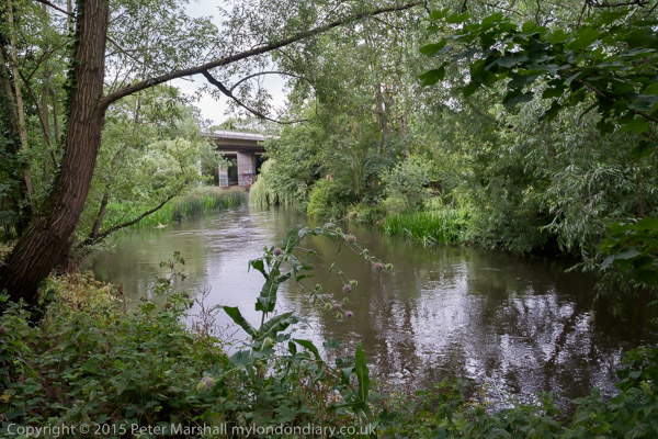
I began and ended the walk at Lewisham Station and I’m unsure whether I made this image – taken on another camera – at the start or finish of my walk. The picture is made on a footpath that leads over the River Ravensbourne around a quarter of a mile south of the station and was taken from just on the east side of the river looking under the railway line towards Molesworth St. Although central Lewisham has changed drastically in the past decade or so, I think both the buildings in the background remain.
My next photographic walk was in North London two weeks later. Coming here shortly.
Flickr – Facebook – My London Diary – Hull Photos – Lea Valley – Paris
London’s Industrial Heritage – London Photos
All photographs on this page are copyright © Peter Marshall.
Contact me to buy prints or licence to reproduce.