More Colour from 1994 in Enfield

More Colour from 1994 in Enfield: In More Ponders End, Enfield Wash, Palmers Green & Brimsdown 1994 I posted a set of pictures made in the first three months of the year. This post includes some more taken in March 1994 mainly along by the Lea Navigation in the London Borough of Enfield and ends with a couple taken in April or May.

My archives from back then are a little disorganised but I’ll try hard not to post any that I’ve previously posted, although a one here is from a site where I’ve previously posted a panoramic images.

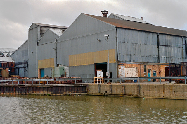
Factory, Lea Navigation, Brimsdown, Enfield, 1994, 94-03-2-45

The Lea Valley was an important industrial area of London well into the 20th century and had been the source of some key inventions, including the start of the electronics industry. Some of the factories were along the river, perhaps originally on sites that had made use of its wharves, but now all reliant on road transport, with all of Brimsdown between the railway and the canal being huge industrial estates off Mollinson Avenue.

Factory, Lea Navigation, Brimsdown, Enfield, 1994, 94-03-2-21

Here the separation of industry from the canal was emphasized with a concrete fence, now rather decaying at the edge of the bank and tell fence topped with barbed wire at an angle to keep intruders from the canal out of the site.

I don’t remember exactly where at Brimsdown this factory was, but like the rest of the industry here it will since have been demolished, replaced by large distribution sheds, some set well back from the water and almost hidden by trees and bushes growing unfettered along the water’s edge.

Hairdressers, Brimsdown, Enfield, 1994, 94-03-2-42

There are houses and a few shops at Brimsdown on the other side of the railway line in what is perhaps part of Enfield Wash, which then included this hairdressers. The Sun’s March 1994 topless ‘Page 3 girl‘ in the calendar (also part reflected in the mirror at right) confirms the date of the picture.

Columbia Wharf, Ponders End, Enfield, 1994, 94-03-2-24

In a previous article I posted a panoramic view of Columbia Wharf looking down from the Lee Valley Road. Here from a little further East on that road with the navigation in the foreground you see the wharf and background the Ponders End Flour Mills, the gas holder and four tower blocks in Ponders End.

Much redevelopment has gone on in Ponders End and only one to those towers remains and there is no gas holder. But the shed at the wharf is still there and in use although Abbey Stainless Components Ltd are no longer there, nor is that large crane and the van boasting ‘NORTH LONDON’S CARRIER PIGEONS IN TRANSIT has long flown the coop.

Ponders End, Enfield, 1994, 94-05-1-53

A more pastoral panorama of Ponders End with Wright’s Flour Mills and the four towers in the background.

Hair Fashion, Ponders End, Enfield, 1994, 94-05-1-21

Lady Jayne remains a well known brand in the Ladies hair trade. I think this shop was probably in the High Street, much of which has now been redeveloped.

Tyre & Exhaust Centre, Ponders End, Enfield, 1994, 94-05-1-24
Tyre & Exhaust Centre, Ponders End, Enfield

Tyre Services Tyre & Exhaust Centre at 151 High Street on the corner with Stonehorse Road, a short ‘No Through Road’ off the High Street. This building was still there in 2022 but had became HiQ and then National Tyres and Autocare – a Halfords company and was by then permanently closed. I expect its days were numbered. Much of the area of the High Street around it was redeveloped around ten years ago.

More colour pictures from 1994 to follow in later posts.


FlickrFacebookMy London DiaryHull PhotosLea ValleyParis
London’s Industrial HeritageLondon Photos

All photographs on this page are copyright © Peter Marshall.
Contact me to buy prints or licence to reproduce.

More Ponders End, Enfield Wash, Palmers Green & Brimsdown 1994

More Ponders End, Enfield Wash, Palmers Green & Brimsdown: Back in 1994 my main focus was on black and white images, some of which I was selling or putting into libraries. I was taking colour on colour negative film and my work was all ‘personal’, with a few being printed for exhibitions.

Hairdressers, Enfield Wash, Enfield, 1994, 94-03-1-52

So while I kept fairly careful records of the black and white images, keeping a diary and annotating the contact prints I made far less documentation for the colour work. Images were filed in sheets which were numbered often for the month I developed them rather than when they were taken and there was no urgency to develop colour film, doing so in batches sometimes covering film from several months.

Shop Window, Palmers Green, Enfield, 1994, 94-03-1-36

Here I’ve tried to present the images in the order they were taken. They come from a whole set of walks around parts of Enfield in the early months of 1994, though I think the first may haven been taken in December 1993.

Mural, Palmers Green, Enfield, 1994, 94-03-1-21

The previous post, Ponders End, Brimsdown, Enfield Wash & Waltham Cross – 1994, included some pictures from the same months, including a panorama made at the same place as one of the images here. I think these pictures speak for themselves so I’ll write nothing more about them.

Back to the Future, Bus, Brimsdown, Enfield, 1994, 94-03-1-23
Cable Drums, Factory, Brimsdown, Enfield, 1994, 94-03-2-64
Fuel Pumps, Brimsdown, Enfield, 1994, 94-03-1-26
Builders Mate, Builders Merchants, The Arena, Mollison Avenue, Brimsdown, Enfield, 1994, 94-03-2-55

Another post of pictures from the London Borough of Enfield later.


FlickrFacebookMy London DiaryHull PhotosLea ValleyParis
London’s Industrial HeritageLondon Photos

All photographs on this page are copyright © Peter Marshall.
Contact me to buy prints or licence to reproduce.


Highbury to Stoke Newington Church Street – 1989

Highbury to Stoke Newington Church Street: Continuing my walk from Sunday 1st October 1989 which had begun at Finsbury Park and continued to the Nags Head before returning to Finsbury Park. The previous post ended on Blackstock Road.

House, Kelross Rd, Northolme Rd, Highbury, Islington, 1989 89-10b-46
House, Kelross Rd, Northolme Rd, Highbury, Islington, 1989

Blackstock Road continues south into Highbury as Highbury Park and I walked some way down this before turning east into Northolme Road. Highbury Park was developed in the 1870s but the houses in Northholme Road date from the 1890s. This and neighbouring roads were built on the Holm Estate and the LCC applied for permission to develop these roads in 1890.

North Holme is near Helmsley, North Riding of Yorkshire and although it has been described as a “township” is a small cluster of buildings, more a farm than even a village close to the River Dove. “The Revd Joseph Parker, DD (1830-1902) … lived in 1866 at a house in Highbury Park he called ‘North Holme‘. The sites of Northolme Road, Sotheby Road and Ardilaun Road were on part of the grounds of his house.” He was the “Minister of the City Temple, 1869-1901, author, preacher and twice
Chairman of the Congregational Union
“.

This house is at the eastern end of Northolme Road, where it meets Kelross Road and is a detached villa rather larger than the terraces along long the rest of the road.

Clissold Park, Stoke Newington, Hackney, 1989 89-10b-35

From here Kelross passage leads to Highbury New Park, a street with villas built from around 1850. But I pressed on across it into Collins Road, making my way towards Clissold Park and Stoke Newington Church St.

Clissold House was built as Paradise House for Quaker City merchant Jonathan Hoare, a noted philanthropist and anti-slavery campaigner and brother of banker Samuel Hoare Jr. The water here was a stretch of the New River which brought clean drinking water from Hertfordshire to London, but I think at some point the river here was culverted, although the bridge taking Stoke Newington Church St across it remained until the 1930s.

The park was first created as grounds for this GradeII listed house. Hoare got into financial difficulties and lost the house and grounds, which passed through several owners before being owned by Augustus Clissold. When he died in 1882 the estate was bought by the Ecclesiastical Commissioners who intended to make money from developing it as housing, but the Metropolitan Board of Works were persuaded in 1887 to buy it to be a public park.

By 1989 the house and park were in a poor condition and Clissold House was put on English Heritages ‘at risk’ register in 1991. Since then both park and house have been restored with the aid of lottery money.

Park Crescent, Spensley Walk, Stoke Newington Church St, Stoke Newington, Hackney, 1989 89-10b-23

Grade II listed Park Crescent at 207-223 Stoke Newington Church Street was built in 1855, but by the 1980s was in a very dilapidated state and became home to around 90 squatters alongside only a handful of legal tenants. The houses were then owned by Hackey council who planned to sell them to housing associations.

Park Crescent, Spensley Walk, Stoke Newington Church St, Stoke Newington, Hackney, 1989  89-10b-11
Park Crescent, Spensley Walk, Stoke Newington Church St, Stoke Newington, Hackney, 1989 89-10b-11

Three motorbikes parked outside one of the houses of Park Crescent. You can clearly see the poor state of the buildings which need Acrow props to support the porches, with the steps at right being roped off to block access to the unsafe building.

Park Crescent now looks very neat and tidy compared to this.

Shops, 185-189, Stoke Newington Church St, Stoke Newington, Hackney, 1989 89-10c-51

The building at 185 Stoke Newington Church St had been sold when I made this picture in October 1989, but The Modern Man, a hairdressers, was still alive in another shop on the street, shown in my next picture.

This row of buildings with ground-floor shops is still there and like the rest of the area has become rather better kept and is now that epitome of gentrification, an estate agents which has also expanded into 187.

Perhaps surprisingly the 5 Star Cleaners at 189 is still a dry cleaners, though under a different name.

The Modern Man, Stoke Newington Church St, Stoke Newington, Hackney, 1989 89-10c-52

I found The Modern Man still in business at 121 Stoke Newington Church St at the corner with Marton Road. It didn’t survive the gentrification of the area and the shop has passed through several hands as ‘frere jacques’, ‘search and rescue, ‘Ooh Lou Lou Cakery’ and ‘The Caffeine Fix’.

I don’t know how long Tanya’s Cafe-Diner Take away lasted but around 2009 it became Lydia Cafe Restaurant and retained the name Lydia until recently becoming ‘The Tiffin Tin.’.

My walk was almost at an end, but I’ll share are few more pictures in a later post.


FlickrFacebookMy London DiaryHull PhotosLea ValleyParis
London’s Industrial HeritageLondon Photos

All photographs on this page are copyright © Peter Marshall.
Contact me to buy prints or licence to reproduce.


More From Beverley Rd – Hull 1989

More From Beverley Rd – continuing my short series of pictures made in Hull in August 1989.

Binnington, Hairdresser, Tobacconist, Beverley Rd, Hull, 1989 89-8m-12

Binnington seems to be a relatively common family name in parts of Yorkshire, though not one I’d come across before elsewhere. It’s hard to read the street number but I think it is 323, one of a short run of shops between the railway bridge and De Grey St on the west side of Beverley Rd.

I hadn’t come across many shops that were both hairdressers and tobacconists, though I think there may have been a couple of others in Hull. I wasn’t sure whether the CLOSED notice in the window was merely out of opening hours or more permanent.

Newland United Reform Church, Beverley Rd, Hull, 1989 89-8m-13
Newland United Reformed Church, Beverley Rd, Hull, 1989 89-8m-13

Newland United Reformed Church was on the corner of Beverley Road and Brooklyn Street but was sold in 2012 and demolished. Nothing had been built on the site by May 2022.

There had been a church here, Hope Street Congregational Church since 1797. In 1903 it had been replaced by Newland Congregational Church, a simplified Gothic brick church designed by Moulds and Porritt in red and yellow brick with terracotta dressings which was demolished in 1969. Presumably it was then replaced with this simpler structure – Newland United Reformed Church from 1972.

Mayfair, Unisex Salon, Hairdressers, May St, Beverley Rd, Hull, 1989 89-8m-14
Mayfair, Unisex Salon, Hairdressers, May St, 398, Beverley Rd, Hull, 1989 89-8m-14

May Street runs east from Beverley Rd, and Mayfair Unisex Salon was on its northern corner with Beverley Rd. As well as the obvious attraction for me of the male and female silhouettes for the ‘SUPPLIERS OF N.H.S WIGS GREAT SELECTION’. But also a face peers down from the upper window.

Hills, Beverley Rd, Hull, 1989 89-8m-15

Not only Mayfair, Hull also had (and still has) its Park Lane, though the lane now looks very different with no trace of Hills or any of its buildings.

The corner is now occupied by a building with a brickwork panel showing a junk and some Chinese characters and was built by the Hon Lok Senior Association along with ten houses and ten bungalows in Park Lane.

Hills, Office, Park Lane, Bull Inn, pub, Beverley Rd, Hull, 1989 89-8m-16

Thomas Hill Engineering Co. (Hull) Ltd had offices on the corner of their site on Park Lane opposite the Bull Inn. I’m not sure what kind of thinks they engineered but apparently in 1977 they were granted US Patent 4031764 on ‘Devices for “rotating articles in which the disadvantages of existing devices are minimized, and in which the containers are kept in line.”

Stepney Chapel, Zion Chapel, Cave St, 219, Beverley Rd, Hull, 1989 89-8n-62

Stepney Chapel is still on the corner of Cave Street and Beverley Road, but now looks in a very sorry state, around ten years or more since there were last services at Glad Tidings Hall (Pentecostal). The Chapel was built in 1849 when Stepney was still a small village as a Methodist New Connexion Chapel, but was replaced in 1869 by a much larger and grander Gothic church with seating for 600. This closed in 1966 and was demolished with a supermarket now on its site.

The Methodist New Connexion began in Sheffield in 1797 by secession from the Wesleyan Methodists led by Alexander Kilham and William Thom and grew rapidly. Accused of having sympathies with Tom Paine and the French Revolution it gave greater power to the lay member of the churches than the minister dominated Wesleyan Methodists. It grew rapidly paricularly across the north of England, though in the 20th century the various Methodist groupings re-united. William Booth, founder of the Salvation Army, was ordained as a Methodist New Connexion Minister in 1858.

As my picture shows clearly, the chapel is aligned to Cave St rather than Beverley Rd.

More pictures from Hull in a later post.


FlickrFacebookMy London DiaryHull PhotosLea ValleyParis
London’s Industrial HeritageLondon Photos

All photographs on this page are copyright © Peter Marshall.
Contact me to buy prints or licence to reproduce.


Bermondsey St, the Green Dragon & Crucifix Lane

The previous post on this walk on Sunday 30th October 1988 was Dockhead, Sarsons, Tanner St and Bermondsey Square.

Bermondsey St, Bermondsey, Southwark, 1988 88-10r-63-Edit_2400
Bermondsey St, Bermondsey, Southwark, 1988 88-10r-63

I walked back up Bermondsey Street. There was slanting light across many of the frontages on the east side of the street and I stopped to take pictures of several of the more interesting buildings. Turner Whitehead were in these tall warehouses at 65-71, now renamed Bramah House. As I noted in an earlier, Turner Whitehead described themselves as ‘polythene converters’ meaning they made and sold a wide range of polythene products including bags etc.and these fine late Victorian buildings were said to have been tea warehouses.

Bermondsey St, Bermondsey, Southwark, 1988 88-10r-51-Edit_2400
Bermondsey St, Bermondsey, Southwark, 1988 88-10r-51

I’d photographed 65-71 Bermondsey St before together with this building next door at No63 and was pleased to have better lighting to take another picture. This site was occupied by the Green Dragon pub from at least 1822, probably much earlier. The building probably dates from around the end of the nineteenth century and the pub appears to have closed and been converted to commercial use in the 1920s. Now the ground floor is an estate agents.

The Green Dragon was an emblem of the Earls of Pembroke, one of whom, Japer Tudor, born around 1431 was the son of Catherine of Valois, the widow of King Henry V (and mother of Henry VI) and her Welsh clerk of the Wardrobe Owen Tudor. The couple were said to have married secretly in 1429 and managed to have at least five children before their marriage was discovered; then Owen Tudor was imprisoned and Catherine de Valois sent to live in Bermondsey Abbey. She died in disgrace in 1437 but was still buried in Westminster Abbey.

Bermondsey St, Bermondsey, Southwark, 1988 88-10r-66-Edit_2400
Bermondsey St, Bermondsey, Southwark, 1988 88-10r-66

Next going up Bermondsey street on the other side of what is now Vintage Yard is this fine Grade II listed 3 storey building at No 59, built as a new police station for the Metropolitan Police in 1851. When a new Tower Bridge Police Station opened in 1904 it briefly became a police section house and in 1906 was converted to commercial use. At least until the 1960s it was occupied by Read & Partners Ltd. Since I took this picture in 1988 it has been internally refurbished as offices.

Hairdresser, Bermondsey St, Bermondsey, Southwark, 1988 88-10r-62-Edit_2400
Hairdresser, Bermondsey St, Bermondsey, Southwark, 1988 88-10r-62

I walked back up Bermondsey Street, pausing to photograph this image in the window of a barber’s shop. That long-haired figure seemed strangely familiar.

Bermondsey St, Bermondsey, Southwark, 1988 88-10r-53-Edit_2400
Bermondsey St, Bermondsey, Southwark, 1988 88-10r-53

The light now made for a much better picture of Thomson Bros Ltd Knightrider Mills, the gateway shared by Tempo Leather Co Ltd, not to mention Rilling Hills Ltd and Marchant Hills Ltd.

As the notice states, these had been ‘ACQUIRED BY THE ELEPHANT HOUSE CO PLC AND DUNLOW HOUSE PLC – PROPOSED DEVELOPMENT – ALL ENQUIRIES’. Fortunately the development has retained the frontage more or less intact, almost certainly because it is Grade II listed, with gates now leading to ‘Shiva Building – Studio/Offices and ‘The Tanneries – www.lordshiva.net’, which address tells you a little about what goes on inside. It was built in 1873 to the designs of George Legg.

Crucifix Lane, Barnham St,Railway, Guys Hospital, Bermondsey, Southwark, 1988 88-10r-45-Edit_2400
Crucifix Lane, Barnham St, Railway, Guys Hospital, Bermondsey, Southwark, 1988 88-10r-45

This street apparently gets its name from a pub which had the sign of St Christopher who was the bearer of the cross on which Christ was crucified. The pub, named ‘The Cross of Bermondsey’ was apparently demolished in 1559.

More demolition came with the railway, which runs in a wide swathe across Bermondsey, built for the London and Greenwich Railway Company with construction beginning in 1834.

Guys Hospital was founded in 1721 by Thomas Guy who had made a fortune printing Bibles and a killing by speculating on the South Sea Bubble. An early private-public partnership it had been granted a monopoly by the to supply African slaves to South America and the South Sea Islands. Because Spain and Portugal controlled most of South America it did very little business with slaves, but in 1720 pushed up its share price by rumours of support from King and Parliament, rising from £128 to £550 in five months, before rapidly collapsing back. Guy apparently sold his shares before the collapse.

Guy’s Tower was built in 1974 and was then the tallest hospital building in the world, with 34 floors and almost 150 metres tall. According to Wikipedia it is now the world’s fifth-tallest hospital building.

Enid St, Bermondsey, Southwark, 1988 88-10r-35-Edit_2400
Enid St, Bermondsey, Southwark, 1988 88-10r-35

You can see the railway viaduct in the background of this picture on Enid St, which appears to be both the name of the street beside the viaduct and some side-streets on the Neckinger Estate. I can no longer find either the buildings and chimney but I think this may have been taken from around Enid St Playground.

This walk will continue in a later post.