1995 Colour – Poplar, Bow, Leyton, North Woolwich & Silvertown

Poplar, Bow, Leyton, North Woolwich & Silvertown: These pictures come from a number of visits to areas of London working on several different projects and are my final selection of colour panoramas made in 1995. There are a few more colour images, including some panoramas I made in 1995 in the images in the Flickr album as well as many I have not digitised; some very similar to those online, others that I now find of less interest. Some of these were taken as a part of my project on the Greenwich Meridian in London – you can see a set of 16 images from this on the urban landscape web site.

Bow Locks, River Lea, Bow Creek, Bow, Tower Hamlets, 1995, 95p4-752

Bow Locks separate the tidal River Lea from the Lea Navigation and the Limehouse Cut which offers an alternative route to the Thames to avoid the winding and dangerous Bow Creek. First built in 1850 they were remodelled in 1930. At the highest Spring tides water from Bow Creek would overtop the locks and raise the level of the canals here – the locks were modified in 2000 to stop this and avoid the silting it caused.

London Galvanizers, Leven Rd, Poplar, Tower Hamlets, 5p4-743
London Galvanizers, Leven Rd, Poplar, Tower Hamlets, 95p4-743

The Poplar Gas Coompany built a local gas works here in the 1820s at the request of the Poplar Vestry after ratepayers lobbied them to provide gas street lighting. The site was cleared in 2011 and I was commissioned to photograph the removal of toxic earth from the site using barges on Bow Creek. Something around an eigth of the material was removed in this way, tides making the removal of more difficult. The original gasholders had to be built to special safety standards because of their proximity to the West India Dock wall. The last of the gasholders was removed in 2017.

London Galvanizers had modernised their galvanizing plant here in 1983-5 and were one of the most important jobbing galvanizers in London and the Home Counties.

Langthorne Rd, Leyton, Waltham Forest, 1995, 95p4-862

This street corner is close to the Meridian and I had stood here for some time outside the Chinese restaurant which was having some joinery work done. I liked the contrast between its orange paint and the blue on the opposite corner and the warm brown of the Birkbeck Tavern at right. I think I had made at least one exposure when a young girl in a red coat on roller skates came to see what I was doing – and I made this exposure as a red car come around, filling an otherwise rather empty grey space.

St Patrick's Catholic Cemetery, Langthorne Rd, Leyton, Waltham Forest, 1995, 95p4-841
St Patrick’s Catholic Cemetery, Langthorne Rd, Leyton, Waltham Forest, 1995, 95p4-841

The Meridian also passes through this cemetery and I chose a viewpoint which included the cemetery chapel with a fine group of monuments in the foreground, I think all for people of Italian origin.

Stratford Station, Great Eastern Rd, Stratford, 1995, 95p4-963
Stratford Station, Great Eastern Rd, Stratford, Newham,1995, 95p4-963

I’m unsure what this railway building to the east of the station was, perhaps a 1930s signal box. Parts of this area have now been redeveloped, and this has been behind fences for more than ten years and could stil be there, as least in part.

King George V Dock, Woolwich Manor Way, North Woolwich, Newham, 1995, 95p9-171

Finally four pictures from a walk along Woolwich Manor Way, this taken looking westwards along the south side of the King George V Dock. You can see the bridge over the dock entrance at right and the City Airport terminal and Canary Wharf at the end of the dock.

Royal Albert Dock Basin, Woolwich Manor Way, North Woolwich, Newham, 1995, 95p9-161

At left is the old swing bridge that took the road over the dock entrance from the basin. To its right is the elevated DLR and the pumping station at the centre of the Gallions roundabout. Further on only two buildings were standing along the side of the Basin, the Gallions Hotel and the Royal Docks Pumping Station.

Containers, Woolwich Manor Way, North Woolwich, Newham, 1995, 95p9-162

Land to the south of the Royal Albert Dock Basin just east of Woolwich Manor Way.

King George V Lock, Woolwich Manor Way, North Woolwich, Newham, 1995, 95p9-153

This swing bridge across the dock entrance is still there.

Royal Victoria Dock, Silvertown, Newham, 1995, 95p11-262

This was taken from Silvertown Way, looking across the Royal Victoria Dock. There are still cranes along the dockside here but the foreground now has flats. The Millenium Mills are still there, but there is nothing in the picture where the Excel Centre now stands and none of the other new developments on the north side of the dock. The council flats at the right have been demolished.

You can see these and some other colour pictures I took in 1995 at 1995 London Colour.


FlickrFacebookMy London DiaryHull PhotosLea ValleyParis
London’s Industrial HeritageLondon Photos

All photographs on this page are copyright © Peter Marshall.
Contact me to buy prints or licence to reproduce.


Church Hall, Station, Shops, Hospital – Leytonstone 1989

Church Hall, Station, Shops, Hospital – Leytonstone 1989 – more from my walk on Sunday September 3rd 1989.

Dossetter Printcrafts, Leytonstone Rd, Maryland, Stratford, Newham, 1989  89-8p-13
Dossetter Printcrafts, Leytonstone Rd, Maryland, Stratford, Newham, 1989 89-8p-13

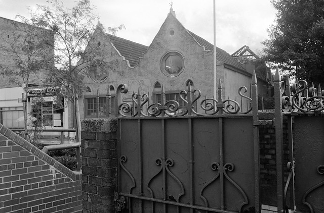
I think this was built as the church hall for Trinity Presbyterian Church. The church was founded in 1863 and the hall was built the following year, the church coming later in 1870. The church closed in 1941 and both church and hall were used as factories. The church burnt down in 1953. This building was certainly still in use by Dossetter in the 1970s but since I photographed it has been replaced by flats. The block at left is still there.

Leytonstone Rd, Maryland, Newham, 1989 89-9a-61

Another view of the former church hall. The road layout was altered at least twice sinc I made this pictre and there is now a pedestrianised area with a 10m spiral tower by Malcolm Robertson carrying a clock.

Maryland Station, Leytonstone Rd, Maryland, Newham, 1989 89-9a-65

Maryland Station was opened as Maryland Point Station in 1873 by the Great Eastern Railway, 34 years after the line was built. It was renamed as simply Maryland in 1940 and the new buildings were built during the war years in LNER Art Deco style, designed by Sir Thomas Penberthy Bennett, then Director of Bricks at the Ministry of Works. Later he was to be the main architect for Crawley New Town and Stevenage. Network SuuthEast, created in 1982, later added their sign which I think fits reasonably well with the rest.

Shops, Leytonstone Rd, Maryland, Newham, 1989 89-9a-66

I could not walk by Scorchers, a 24hr Ironing Service without photographing their signage. I think their 24hrs was the turnaround time rather than suggesting people might have an urgent need for some ironing at say, 3am which they would rush to deal with, though I did have a vision of a van with flashing blue lights and an ironing board rushing through the streets. I cannot now find the exact location and think these buildings may have been on a side street and have probably since been demolished.

Church Hall, Station, Shops, Hospital - Leytonstone 1989

I wouldn’t normally post this in these posts as it is only a very slight variation on an image from my previous post. I’d turned around and taken the pictures above and then came back to this place to make a further six frames – a very unusual thing for me, but I was determined to get this exactly as I wanted it. And here it is with the text that came with it on the web site for my ‘1989’ project.

Again from ‘1989’

Church Hall, Station, Shops, Hospital - Leytonstone 1989
Langthorne Hospital, Thorne Close, Leytonstone, Waltham Forest, 1989 89-9a-56

This splendid building is still there just a little off Leytonstone Road in Thorne Close and was built as the Board Room block for the West Ham Union Workhouse around 1870. In 1930 West Ham Borough Council renamed it the Central Home Public Assistance Institution and it was again renamed when it became art of the NHS as Langthorne Hospital. It continued to specialise in geriatric care and had the motto ‘fiat jucunda senectus’ – let there be the delights of old age. It was finally closed in 1999. The older buildings on the site are all Grade II listed.

Langthorne Health Centre, Langthorne Rd,  Leytonstone, Waltham Forest, 1989 89-9a-41
Langthorne Health Centre, Langthorne Rd, Leytonstone, Waltham Forest, 1989 89-9a-41

The Langthorne Health Centre is still at 13 Langthorne Road, though it appears now to be run by L L Medical Care though still giving NHS treatment.

Church Hall, Station, Shops, Hospital - Leytonstone 1989

Another from the web site – though these images without the text are on Flickr. Here I’m presenting the images in the order they were taken, but in the book and web site they were thoughtfully sequenced – and perhaps make a little more sense. The book preview shows around half of the book’s 20 pictures.

More from this walk to come.


FlickrFacebookMy London DiaryHull PhotosLea ValleyParis
London’s Industrial HeritageLondon Photos

All photographs on this page are copyright © Peter Marshall.
Contact me to buy prints or licence to reproduce.