Bexkleyheath & Crayford: I spent several days in mid-August in Bexley in south-east London visiting Bexleyheath, Crayford and Barnes Cray and some of the areas around, and returned to the area the following month. I think all the pictures in this post were made in August.
Crayford, Bexley, 1994, 94-812-45
Crayford obviously gets its name from a ford over the River Cray, the major tributary of the River Darent which it joins not far from here and short distance from where this flows into the Thames. Its name is thought to mean a fast flowing stream and it powered an number of mills on its route – including a paper mill at Crayford. The tidal creek is still navigable from the Thames to Crayford, and was apparently canalised in 1845. There were still barges serving the flour mill in the 1980s.
Crayford, Bexley, 1994, 94-812-33
Crayford, Bexley, 1994, 94-812-34
Crayford, Bexley, 1994, 94-812-35
Taken through the links of a fence.
The Frontier Post, Bar & Grill, Bexleyheath, Bexley, 1994, 94-812-21
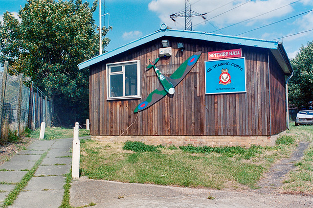
Spitfire Hall, Air Training Corps, Swaisland Drive, Crayford, Bexley, 1994, 94-812-11
Sainsburys, Petrol Station, Roman Way, Crayford, Bexley, 1994, 94-812-12
I returned to Crayford and Barnes Cray the following month, making a number of colour panoramas as well as black and white picture pictures which I’ll post at some time later – or you can find them in my Flickr albums for 1994.
Woolwich Riverside and Royal Artillery: More pictures from my walk around Woolwich in August 1994
Waste Land, Woolwich Church St, Woolwich Ferry, River Thames, Woolwich, Greenwich, 1994, 94-807-42
This area, previously occupied by engineering works, has now been redeveloped with a luxury development of tall housing blocks on Mast Quay, “A magnificent crafted living space with panoramic views of the River Thames.”
As well as getting a free ferry, Woolwich also got a foot tunnel under the River Thames, opened by the London County Council in 1912. The tunnel is just over 500 meters long and remains delightfully cool on hot summer days.
Many cyclists also use the tunnel despite bylwws prohibiting cyclists. Electronic signs were installed in 2016 which used a computerised system to measure traffic and messaged ‘No cycling allowed‘ in red at busy times but ‘Please consider pedestrians‘ in green when the tunnel was fairly empty. Greenwich council was in favour of changing the bylaws to legalise this, but Tower Hamlets refused and the system was discontinued. Many cyclists still ride.
The tunnel provides a useful route across the river, particularly when the ferry is out of action, but most times I’ve used it one of both of the lifts at each end have not been working. I’ve never counted the steps but there are rather a lot of them, particularly when going up.
River Thames, Woolwich, Greenwich, 1994, 94-809-21
Downstream from the ferry in what in 1994 was I think an open area, once the site of Woolwich Power Station, demolished in 1978-9 though the coaling jetty in this picture is still there. There is still a riverside walk but most of the site is now occupied by tall blocks of flats.
River Thames, Woolwich, Greenwich, 1994, 94-809-22
A bridge here links the former coaling jetty with the riverside path.
Steps from Riverside Path, Woolwich, Greenwich, 1994, 94-809-33
This area is now covered by tall flats, though there is a small segment of parkland with fountains.
I cannot remember exactly where I found this mural of the Thames Barrier in Woolwich and I think it was soon demolished.
Royal Artillery Memorial, St George’s Garrison Church, Grand Depot Road, Woolwich, Greenwich, 1994, 94-812-52
Built for the garrison in 1862-3 it was hit by a V1 flying bomb in 1944 and the church was largely destroyed by fire. In 1970 more of the building was demolished but a canopy roof added to protect the apse and its polychromatic Victorian brick and decorations, with a memorial garden added in the former nave. It was listed in 1973. In 2011 it was transferred out of military ownership and since then there has been some restoration work, partly lottery funded.
Cannon, Royal Artillery Barracks, Woolwich, Greenwich, 1994, 94-808-32
The barracks was the home of the Royal Artillery from 1776 until 2007. Its 1,000 foot long Georgian frontage is said to be the longest in Europe if not the world. Since 2007 most of it has been rebuilt behind this, and in 2016 the Ministry of Defence announced plans for all army units to move out by 2028.
The cannon is the “17.75-ton Bhurtpore gun, captured by Field Marshall the Viscount Combermere after the 1826 siege of Bhurtpore” and brought here in 1828. When the Royal Artillery moved out they took this and four other cannons with them, doubtless a vital part of our country’s defence.
More From the Woolwich Free Ferry: I went on the ferry across to North Woolwich, taking pictures while I was on the ferry, I think mainly in black and white.
Woolwich Ferry, River Thames, Woolwich, Greenwich, 1994, 94-810-51
Taken while I was waiting at Woolwich for vehicles and passengers could come off the ferry.
Woolwich Ferry, River Thames, Woolwich, Greenwich, 1994, 94-811-42
At North Woolwich while vehicles were still driving off and foot passengers were boarding for the journey to Woolwich.
Riverside Path, River Thames, North Woolwich, Greenwich, 1994, 94-810-12
I got off the ferry at North Woolwich and took a short walk along the riverside path, making this picture and then returning to catch the ferry back. This screw was in the path. The ferry terminal is at right.
Woolwich Ferry, River Thames, Woolwich, Greenwich, 1994, 94-810-32
I don’t know whether the pictures below on the ferry were made on the outward or return journey.
Woolwich Ferry, River Thames, Woolwich, Greenwich, 1994, 94-810-33
Woolwich Ferry, River Thames, Woolwich, Greenwich, 1994, 94-810-41
Soon I was back in Woolwich and taking more pictures there – to be in a later post.
The Woolwich Ferry: Continuing my walk in Plumstead and Woolwich in August 1994 I came to the Woolwich Ferry and couldn’t resist taking a ride across the river on it. And since I wanted to continue my walk in Woolwich, rather than in North Woolwich, I stayed on the ferry to come back.
Woolwich Ferry, River Thames, Woolwich, Greenwich, 1994, 94-808-41
There had almost certainly been a ferry across the Thames at Woolwich at least since the Norman Conquest, though the first written reference by name only came when it was sold together with a house by William de Wicton to William atte Halle for £10. In the early years of the 19th century there were three Woolwich Ferry Acts (1811, 1815 and 1816) establishing a commercial ferry.
These were passed in particular for the movement of troops and supplies from Woolwich Arsenal across the river. From 1846 there was also a rail connection from North Woolwich to Stratford and eventually there were three steam ferries on the route
Woolwich Ferry, Ambulance Station, River Thames, Woolwich, Greenwich, 1994, 94-807-11
After the Metropolitan Board of Works (MBW) was created in 1855 it had taken over toll bridges in West London and made them free to use. People to the east of London in Greenwich and Woolwich argued that they should also be able to cross the river without paying. Eventually in 1884 the MWB agreed and tasked Sir Joseph Bazalgette to oversee the provision of approaches, bridges and pontoons for the ferry. These were built by the still familiar name of Messrs Mowlem in 1887-9. (The company is no longer; having got into financial difficulties it was acquired by its rival Carillion in 2005.)
Woolwich Ferry, River Thames, Woolwich, Greenwich, 1994, 94-807-12
The London County Council was established on 21st March 1889, two days before the Free Ferry was due to open and so it was Lord Roseberry, the LCC’s first chairman who led the huge procession and festivities to the new ferry terminal in Woolwich and announced to a crowd of thousands “The free ferry is open to the public.“
There was only one paddle steamer working the ferry that weekend and it must have got very crowded. As well as those in Woolwich , “the Great Eastern Railway Company carried 25,000 people to its North Woolwich terminus, most of whom were intent on riding the ferry.”
Woolwich Ferry, River Thames, Woolwich, Greenwich, 1994, 94-807-13
The initial fleet of two paddle steamers soon became three and were replaced by newer paddle steamers in the 1920s. It was these that inspired the story and wonderful illustrations by Charles Keeping in his 1968 children’s classic ‘Alfie and the Ferryboat (1968), very much enjoyed a few years later by myself and my two boys. So of course we had to come to Woolwich and I took my first crossing with them in the early 1980s.
Woolwich Ferry, Ambulance Station, River Thames, Woolwich, Greenwich, 1994, 94-807-11
But by the time that book was published the paddle steamers had gone, replaced from 1963 by the diesel-powered double ended James Newman, John Burns and Ernest Bevin which enabled vehicles to drive up newly built causeways with hinged bridges and drive directly onto the ferries, greatly speeding up the loading. As they were double-ended vehicles could also drive off forwards on the other side and the ships did not need to reverse. They were steered from a central bridge over their roadways.
Woolwich Ferry, River Thames, Woolwich, Greenwich, 1994, 94-807-12
The ferries in my pictures continued in service until 2018, when the ferry closed down for four months waiting the arrive of replacements. These have had various problems with London May Sadiq Khan apologising and saying the new vessels “aren’t good enough.”
Woolwich Ferry, River Thames, Woolwich, Greenwich, 1994, 94-807-13
Woolwich Ferry, Ambulance Station, River Thames, Woolwich, Greenwich, 1994, 94-807-22
I had just missed the ferry and spent it walking around the area and taking pictures.
Woolwich Ferry, Ambulance Station, River Thames, Woolwich, Greenwich, 1994, 94-807-33
All of the pictures before this one have been of a vessel not in use, moored at Woolwich but in this picture you can see one ferry at the North Woolwich terminal and another approaching Woolwich, and I hurried up the approach to catch it. In my next post from 1994 I will include some pictures I made on the ferry.
Plumstead is a hilly place, rising quite steeply from the River Thames as I remember from my first visit to the area when still in short trousers, trudging up a long hill holding my mother’s hand to visit some distant relatives, whose names I no longer remember, nor exactly where they lived. Their back garden went up steeply behind the terrace house.
I don’t think it was this road was the one I walked up back then, but it was still hilly and you can see the houses going down on both sides and I think in the distance to trees and buildings on the other side of the river.
Park, Plumstead Common, Plumstead, Woolwich, Greenwich, 1994, 94-809-61
The previous picture was taken just a few yards from Winn’s Common, one of several areas also including Bleak Hill and The Slade which make up Plumstead Common. I think this is close to Lakedale Road and shows the foundations of a building with beyond it the rose garden in the next picture.
Park, Plumstead Common, Plumstead, Woolwich, Greenwich, 1994, 94-808-13
I made several other pictures on Plumstead Common, though I can’t remember exactly where on the common this was and can find no traces now of this sunken garden with walkways which must once have been covered by plants and flowers but seem to have left in a semi-derelict state, though there are still some rose bushes.
Here I deliberately tilted the panoramic camera to give a curved horizon rather than try to level it with a spirit level as I usually did, partly to include the lower edge of the bushes and small trees, but also to create a kind of enclosed space.
Across the common is a pub, the Woodman, one of the 5 Plumstead Common Idlers, ‘the Woodman who never felled a tree’ at 35 The Slade.
“The Star which doesn’t shine in the sky, the Woodman who doesn’t cut down trees, the Ship that cannot sail the seas, the Mill which doesn’t grind corn, and Who’d a Thought it!”
Radnor Crescent is some distance to the east on the edge of Winn’s Common and I’m not sure exactly which direction I was looking to make this picture, perhaps looking towreds Shooters Hill.
Waste Land, Woolwich Church St, Woolwich Ferry, River Thames, Woolwich, Greenwich, 1994, 94-807-42
From here I walked to Woolwich and the Woolwich Ferry. More pictures from Woolwich in a later post.
Belvedere Riverside & Plumstead: Some more pictures including some panoramas from my Thames riverside walk on Monday 1st August 1994, and a few from Plumstead a few days later.
Ford Ferry, Pier, River Thames, Belvedere, Bexley, 1994, 94-805-22
Ford at Dagenham was just on the opposite bank of the Thames, with a Ford ship moored in front of it and some ominous black smoke rising.
But although the Ford was only around 600 metres away, the fastest route for workers driving from here to the factory was around 15 miles. Taking the Woolwich ferry would take a couple of miles off this, but be slower.
Ford Ferry, Pier, River Thames, Belvedere, Bexley, 1994, 94-802-11
Many of Ford’s workers did live south of the river, either in Thamesmead or further away, and Ford provided a large suppposedly secure car park here from which they could walk down the pier to the Ford Ferry to take them across the river.
Ford had come to Dagenham in 1929 and opened the factory in 1931. They set up the private ferry for workers living in Kent in 1933. In its heyday it made 50 crossings a day taking as many as 1,500 workers to and from the plant, but after vehicle production ended with the plant turning to making engines it was only taking around 240 across and Ford discontinued it in 2003. Eventually they were forced to pay around half a million in compensation and to provide a bus service instead.
Much earlier there had been a Pilgrims ferry from Rainham to Erith, for pilgrims on their way to Canterbury, said to have begun in 1199 and to have continued in use until the mid 1950s.
Riverside Path, River Thames, Belvedere, Bexley, 1994, 94-802-12
Around here I turned back towards Erith, taking some more pictures on my way (some of which were included in my previous post.)
Riverside Path, River Thames, Belvedere, Bexley, 1994, 94-802-13
I can’t now remember exactly where on the path this was, but I think I walked all the way back to Erith and to the station there.
Penny’s Cafe, Motor Auctions, Manor Road, Erith, Bexley, 1994, 94-803-32
Finally from that day in Erith, one I took earlier around the start of my walk but failed to post previously. Manor Road leads out east from Erith and was then an industrial area.
This Café (and Motor Auctions) had also clearly once been a factory and still catered for workers in nearby factories. Facebook posts say it had been an engineering factory called Ivor & Jettage, that the café was full of boxing photos and that its yard, used for motor auctions and later car boot sales on Sundays, was in 2024 a scaffolding yard. But I have been unable to confirm this.
Nathan Way, Plumstead, Greenwich, 1994, 94-806-52
A few days after my Erith walk I was back not far away in Plumstead, and made just a handful of colour images including these three.
This picture was made from The Ridgeway a foot and cycle path on top of the Southern Outfall Sewer from Plumstead to Crossness. Nathan Way runs for around 600 metres just to the north of this and most industrial sites along here were demolished by 2015 and are being replaced by a huge estate of blocks of flats, Lombard Square, with 1,913 new homes. The first were finished in 2025.
Nathan Way, Plumstead, Greenwich, 1994, 94-805-24
Another image from The Greenway not far from where I made the panorama above. From 1888-90 here or close by Royal Arsenal football team played here at what became the Manor Ground. They moved next to Woolwich, becoming Woolwich Arsenal but soon found the rent there too high and moved back. They played their last game here in 1913 before moving to Highbury in North London – and of course losing the Woolwich.
Some industry remains at the east end of this stretch of Nathan Way but I’m not sure this includes any in my picture.
Nathan Way is a long road leading from Plumsteaad to Thamesmead and I think this may have been on the corner with Kellner Road.. But the name repeated on the lorry and the large modern shed behind as well as on what was perhas a small shed in the foreground was unmissable. I just had to make a Panorama.
Tony’s Snack Bar, Nathan Way, Plumstead, Greenwich, 1994, 94-805-26
I think the building at left it 115 Nathan Way, now occupied by Hydraquip Hose & Hydraulics, while behind are the roofs of Belmarsh Prison. But the picture is about the mobile snack bar here and the neat empty row of six white chairs for its then non-existent customers.
My walk continued on into Thamesmead but although I took quite a few black and white pictures I can’t at the moment find any more colour – and perhaps I took none.
More From the Riverside: More pictures from my walk by the River Thames at Erith and Belvedere on Monday 1st August 1994 to its end in Plumstead.
My previous post from this walk, Thames Riverside – Erith 1994 ended as I approached the Erith Oil Works jetty. The path here climbs up to go over the roadway from the jetty into the works which provided some good views of the jetty,
Jetty, River Thames, Erith Oil Works, Erith, Bexley, 1994, 94-802-52
This whole shoreline was once lined by industrial sites with their own jetties, by 1994 mainly like this now derelict and shortened.
Riverside Path, River Thames, Belvedere, Bexley, 1994, 94-805-45
Riverside Path, River Thames, Belvedere, Bexley, 1994, 94-805-32
Looking inshore there will still industrial sites, but much no longer relying on the river, though there were still some like the aggregate works that still had working jetties.
Jetty, Riverside Path, River Thames, Erith, Bexley, 1994, 94-802-43
Another disused jetty a short distance upstream from the Oil Works.
Sheds and neat stacks of orange and green boxes at a wharf – now serviced by road – at Mulberry Way. This gets its name from the temporary portable floating harbours some of which were constructed here in 1944 by Nuttall Brothers and towed to the French coast after D-Day to land supplies for the Allied invasion. Two temporary harbours were constructed on the Normandy coast; one only lasted a few days before being destroyed by a storm but that at Arromanches remained in use for 10 months.
A panoraamic view from the same viewpoint as the previous image. I had climbed up on the wide concrete flood defence wall here to make the picture. The sky was filled with clouds, perfect weather for panoramic landscapes.
Remains of wharf, Riverside Path, River Thames, Belvedere, Bexley, 1994, 94-802-21
I kept walking along the riverside path, coming to these timbers which would once have supported a long landing stage on a wharf with a short jetty into deep water. Across the river you can see Tilbury Docks at the left of the picture, with the blue hull of a ship there and some cranes, and further towards the centre the chimney and turbine hall of East Tilbury Power Station.
The horizon, dead centre in the picture is straight but as you move further down in the picture the curvature produced by the cylindrical perspective become more and more apparent. The path at left is straight and it remained straight to where I was standing to take the picture and beyond. Usually I tried to compose photographs so that this curvature was less apparent, but here I rather liked the effect.
I was working with two swing lens panoramic cameras (and two ‘normal’ SLR cameras.) Normal wide-angle lenses use rectilinear perspective become unusable with a horizontal angle of view of around 90 degrees as the distance from the centre of the lens to the film increases as light travels to the edges of the frame, increasing the size of image objects. The curved film plane in a swing lens camera keeps the lens centre to film distance constant so objects are recorded at the same scale across the image. Of course the wooden posts get smaller in the image the further away they are from the camera.
Riverside Path, River Thames, Belvedere, Bexley, 1994, 94-802-23
The curvature is much less apparent in this image taken a few minutes later and a few yards further upstream. But the shadow at bottom left as actually the shadow of the same straight flood wall as the larger shadow at the right.
Both of the panoramic cameras I had gave images with a horizontal angle of view of somewhere around 130 degrees.
I’ll post more pictures from this walk later. More pictures also in my Flickr album 1994 London colour – and you can see these images larger there by clicking on them in this post.
1994 London Colour – City, Limehouse & Canning Town: More of my colour pictures made in July or the start of August 1994, in the City of London, Limehouse and at the Royal Victoria Dock in Canning Town.
Red Chairs, London, 1994, 94-722-51
I can no longer remember where I saw this circle of chairs, left after a celebration of some kind. Reflected in the background I can see myself looking in, probably from one of the highwalks in the City, with a whole range of buildings behind me, none of which I can immediately recognise. I am standing in sunlight, which shines on the foreground chairs, but the back of the room is in fluorescent lighting, giving it an unnatural blued-green tint. A single empty glass on the decorated table and a stubbed out cigarette on the floor remain from the earlier gathering.
Fleet Place, City, 1994, 94-722-26
Fleet Place is immediately east of City Thameslink Station and this is one of London’s private pedestrian areas – like Broadgate and Canary Wharf – where various activities, including photography are not permitted.
Fleet Place, City, 1994, 94-723-61
I took a few pictures in Fleet Place on several occasions but was usually then approached by the private security men and told that photography was not allowed. But I generally work fairly quickly, though using the panoramic camera is rather slower than a normal camera as it needs careful levelling. But usually by the time I was told I could not take photographs I had already done so and was happy to leave the premises. But I think I took this in rather a hurry and underexposed it – perhaps seeing the man approaching.
A skeleton around the spine of a tower block in Limehouse, with the wall paper and paint of the flats that were once attached.
Car Sales, Royal Navy, pub, 53 Salmon Lane, Limehouse, Tower Hamlets, 1994, 94-803-44
Car sales and the typical bunting around them on the corner of Condor Street aand Salmon Lane. The Royal Navy pub at 53 Salmon Lane was open by 1856 but closed permanently in 1999 and was converted into flats four years later.
The Tidal Basin Pumping Station designed by Richard Rogers and built in 1998 is one of the three pumping stations that prevent the former marshy areas to the north of the Royal Docks from flooding, pumping out surface water into the Thames, allowing their redevelopment by the LDDC. It was built in a colourful post-modern fashion in a deliberate attempt to provide a colourful accent in the area.
Warehouses, Royal Victoria Dock, Canning Town, Newham, 1994, 94-723-25
The part of the dock in the left foreground has now been built over, but six cranes remain on the dockside.
Royal Victoria Dock, Canning Town, Newham, 1994, 94-803-61
Spillers Millenium Mills were “designed and built by millers William Vernon & Sons of West Float, Birkenhead in 1905” and were the last of the large mills built on the dock, following those of the Cooperative Wholesale Society and Joseph Rank. All the mills were damaged by the 1917 Silvertown explosion. Spillers took over the mill in 1920 and rebuilt it “as a 10-storey concrete art deco building in 1933.” Badly damaged by bombing it was again rebuilt after the war, reopening in 1953. The dock closed in 1981, and the other buildings in the picture have since been demolished.
Nine from Around Stepney: I spent a day on Sunday 17th July 1994 walking around Stepney and straying into some neighbouring areas of East London, making almost 300 black and white pictures mainly of streets and buildings, some of which you can see in my Flickr album 1984 London Photographs.
But I was carrying two Olympus OM4 cameras, and one was loaded with Fujicolor film, and I also made a few colour pictures. Here are ten from the single colour film I used on that day. For once I won’t write much about them, partly because I made very few notes about them when I was making them. My colour work at the time was entirely personal work.
Torn posters, Stepney, Tower Hamlets, 1994, 94-722-42
Closing Down Sale, Stepney, Tower Hamlets, 1994, 94-722-43
Bow Creek and Poplar Panoramas: It was before Christmas that I posted the previous set of panoramic images I made in July 1994 along the DLR between Poplar and Beckton, DLR – Connaught Rd & Bow Creek 1994. Here is the final set I made then.
Another picture taken from the East India Dock Road, looking down at Wharfside Road and the sawmills with their address on Barking Road. The road layouts here have changed with the building of Newham Way flyover and I think Barking Road which earlier began at the ‘Iron Bridge’ over Bow Creek now only starts at the roundabout about 250 yards or so to the east.
As the noticeboard states the entrance to the site is from Wharfside Road on the opposite side of the road, and any driver unfortunate to read the sign would be faced with a long detour to reach it.
M&J Reuben Ltd was founded in 1895 and seems to have moved from the area in 2004 when the then managing director David Reuben retired. London Sawmills Ltd also had timber sheds at Hercules Wharf in Orchard Place closer to the mouth of Bow Creek.
Bow Creek appears on both sides of this roughly 130 degree view, upstream at right, flowing under the bridges and in a long loop and coming up at the left past Pura Foods where London City Island now is, before turning round the other side of Pura foods to flow down to the Thames.
Bow Creek, East India Dock Rd, Canning Town, Tower Hamlets, Newham, 1994, 94-720-12
Moving a few yards to the west along East India Dock Road I made this picture standing on the bridge. The Iron Bridge, built in 1810, was the first road bridge to use cast-iron columns and made a new lower route across Bow Creek. It has now been replaced and the current bridge is concrete.
On the left of the river is Essex Wharf, with the sawmills out of picture to the left. The first bridge on the river, a pipe bridge for a large gas pipe, was demolished soon after, but its brick piers remain. The second bridge is now the ‘Blue Bridge’ though in my picture it is grey. A third, a disused single track rail bridge, is hidden by those in front.
Construction work, South Bromley, Tower Hamlets, 1994, 94-721-62
A little further on but I think still on or close to the East India Dock Road I made this picture looking across a construction site, the DLR, Bow Creek and Pura Foods. I think that the tunnel which connects East India Dock Road to Aspen Way is under the site here.
Aspen Way, East India DLR, South Bromley, Tower Hamlets, 1994, 94-720-51
East India Dock Station on Aspen Way, looking west. At left is the Telehouse South and the Blackwall Tunnel ventilation shafts. Then along the horizon some 1930s council flats and buildings aroudn Canary Wharf including the tower. On the other side of the DLR viaduct is the Grade II listed former hydraulic pumping station in Naval Row and over the dock wall the ugly 1990s buildings on the former East India Dock.
DLR, Poplar, Tower Hamlets, 1994, 94-721-11
Finally a view through the rear window of a DLR train on its way from Poplar to Canary Wharf. Poplar Station can just be seen under the long footbridge across the DLR and the Wes India Dock Road. At left is the DLR line towards Tower Gateway.
The next post in this series of my colour pictures will feature pictures made in July 1994 here and elsewhere using a normal camera.