Posts Tagged ‘warehouses’

River Hull 1989

Sunday, March 24th, 2024

River Hull 1989: I always enjoy a walk by the River Hull and back in the 1970s-90s there was always plenty to photograph, though it is rather less interesting now. My problem then was always to drag myself away and move to a different location. If you click on any of these pictures it will take you to a larger image on Flickr and you can then move forward or backward through the whole set I’ve put on-line.

Drypool Bridge, River Hull, Hull, 1989 89-8e-52

Looking upstream from Drypool Bridge you can see an industrial landscape, most of which has now disappeared, as well as several vessels on the river.

River Hull, downstream, Drypool Bridge, Hull, 1989,  89-8e-53
River Hull, downstream, Drypool Bridge, Hull, 1989, 89-8e-53

Turning around and looking out towards the Humber this was the view, one that I’d taken many times in earlier years when the river had been far more crowded. At left is the disused entrance to Victoria Dock and further down the Northern Divers building, sand and gravel works, warehouses and the Myton Swing Bridge built in 1979 to take the A63 leading to Hull Docks. Before then the traffic had gone various Hull ring roads and and the decision to put it through here, splitting off the city centre from the old town was something of a disaster for the city.

Burdale H, Ranks, Clarence Mill, River Hull, Hull, 1989 89-8e-56
Burdalen, Ranks, Clarence Mill, River Hull, Hull, 1989 89-8e-43

Rank’s Clarence Mill on the east bank of the river just downstream of Drypool Bridge had introduced improved methods of bulk handling, sucking up grain from barges moored at the jetty on which I was standing to make this picture.

Although the Victoria Docks had closed in 1979, the entrance to them here remained in use as the only place the River Hull was wide enough to swing vessels like this Rix coastal tanker around. It will have gone up forward to the Rix depot a little over a mile away on Wincolmlee, and then come backwards downriver on the tide until here, where it could turn and then proceed forwards to the Humber. I took a whole series of the Burdalen turning and you can see a few more on Flickr.

Drypool Bridge, Clarence Mill, River Hull, Hull, 1989 89-8e-44

Drypool Bridge and North Bridge are both Scherzer Rolling Bascule Bridges with a large counterweight at the left-hand end in my picture and a curved track below that which rolls on rails at ground level. Because of the counterweight relatively little force is needed to raise the bridge to allow river traffic to pass through. River traffic was heavily dependent on the tides, and the bridge always seemed to block road traffic at the most inconvenient times.

When the mill was in use the pipes at the top of the image could be lowered into the holds of the barges moored below.

Clarence Mill, Drypool Bridge, Dry Dock, River Hull, Hull, 1989 89-8e-45

A riverside walk led north along the east side of the River Hull, though in 1989 it was largely covered by large amounts of scrap iron at the end of the Union Dry Dock on Great Union St, Hull. The Drypool Engineering and Dry Dock Company Limited of Hull had a number of sites around the city and in Selby by went bust in 1976.

Clarence Mill, Joseph Rank’s great flour mill in Hull was rebuilt after wartime damage and was only finally closed in 2005. With the City Council’s usual disregard for Hull’s heritage it was demolished in 2015 to make way for a hotel which was never built. The site was still undeveloped in 2022.

Pipes, Dry Dock, River Hull, Hull, 1989 89-8e-33

More of the scrap metal which partly blocked the riverside path, including a anchor.

Pipes, Dry Dock, Clarence Mill, Hull, 1989 89-8e-22

And another view of the mills over the pipes at the Union Dry Dock. The closer building is the Shotwell Mill, still standing. Gamebore Cartridges makes shotgun catridges here, and should not be confused with the Hull Cartridge Company Limited who also make cartridges and sporting goods in Bontoft Ave, Hull. I’ve never owned a shotgun and certainly can’t comment on the relative merits.

As well as finding more pictures on Flickr in both black and white and colour you can also buy my 36 page Cafe Royal zine, Peter Marshall — The River Hull 1977–85, which has some of the best of my earlier images.


FlickrFacebookMy London DiaryHull PhotosLea ValleyParis
London’s Industrial HeritageLondon Photos

All photographs on this page are copyright © Peter Marshall.
Contact me to buy prints or licence to reproduce.


West India – North Dock 1988

Sunday, November 21st, 2021

The Ledger Building,  Hertsmere Rd, West India Docks, Poplar, Tower Hamlets, 1988 88-6c-52-positive_2400
The Ledger Building, Hertsmere Rd, West India Docks, Poplar, Tower Hamlets, 1988 88-6c-52

The Offices of the West India Docks an Hertsmere Rd at the west corner of what was the Import Dock of the West India Docks and were Grade I listed in 1950 together with the adjoining warehouses. They were built in 1803 , architect George Gwilt and converted to hold the dock ledgers by John Rennie, who added the portico in 1827.

In 2000 it was converted into a Wetherspoon pub, the Ledger Office and can be visited during normal opening hours and displays some information about the history of the docks which can be read while drinking a cheap pint.

Warehouses, Hertsmere Rd, West India Docks, Poplar, Tower Hamlets, 1988 88-6c-53-positive_2400
Warehouses, Hertsmere Rd, West India Docks, Poplar, Tower Hamlets, 1988 88-6c-53

These listed warehouses are now converted for various uses including the Museum of London Docklands which has both permanent and temporary displays on the history of the River Thames, the growth of Port of London and the docks historical link to the Atlantic slave trade, in which this building, a sugar warehouse, played an important role. Temporary exhibitions there have included some of my pictures including in the show ‘Estuary‘ celebrating the museum’s 10th anniversary in 2013

Warehouses, Hertsmere Rd, West India Docks, Poplar, Tower Hamlets, 1988 88-6c-55-positive_2400
Warehouses, Hertsmere Rd, West India Docks, Poplar, Tower Hamlets, 1988 88-6c-55

The area has been opened up by the removal of the dockside sheds and is now a popular tourist venue, though it has lost most of its previous allure. But it’s still an interesting area, both for the old and the new buildings.

Crane, West India Quay, Poplar, Tower Hamlets, 1988 88-6c-44-positive_2400
Crane, West India Quay, Poplar, Tower Hamlets, 1988 88-6c-44

Two dockside cranes remain on the side of the dock, close to West India Quay DLR station, perhaps left there to divert attention from a rather hideous hotel building to their north.

Bridge, West India Quay, Poplar, Tower Hamlets, 1988 88-6c-45-positive_2400

This picture taken I think from more or less underneath the DLR which goes across the North (Import) Dock gives some impression of the scale of the West India Docks , which I think when constructed in 1800-1806 were I think the largest enclosed high-security docks in the world – and a model for later docks elsewhere.

This dock now looks considerably smaller, with around half of its width taken up by a strange building on top of a new Crossrail station, looking to me rather like a woodlouse. Nothing in this picture remains except the listed dock wall at bottom left (and possibly the bollard on it.)

Bridge, West India Quay, Poplar, Tower Hamlets, 1988 88-6c-46-positive_2400

I think this bridge, built from what looks suspiciously like Meccano, was the Great Wharf Road Bridge, later replaced by what was intended as a more permanent structure as the Upper Bank Street Bridge. I can find no information about it on-line, but it appears to have a central lifting section with heavy counterweights in those four towers. That more permanent bridge was removed for the construction of the Crossrail station in 2012 and a new, much shorter bridge was built in five sections in Belgium by Hollandia and welded together in situ in, opening in 2020.

Docklands Light Railway, Poplar, Tower Hamlets, 1988 88-6c-32-positive_2400
Docklands Light Railway, Poplar, Tower Hamlets, 1988 88-6c-32

It was time to leave Docklands for home, and together with my two young assistants we got on the DLR, sitting right at the front of the train. This view from the front window as the train had just left Poplar Station and about to cross Aspen Way shows dockland cranes at left and St Anne’s Limehouse at right. Then DLR trains were single two-carriage units like the Stratford service in this picture.

This is the final part of posts here about my pictures from my walk around the docks on the Isle of Dogs in June 1988.

Click on any of the pictures to see a larger version in my album 1988 London Photos, from where you can browse the album. The pictures there are largely ordered by my negative reference numbers, which do not in detail reflect the order in which the pictures were taken used in the posts here.


Around Old St

Saturday, November 6th, 2021
H J Brooks & Co, Old St, Islington, 1988 88-5n-22-positive_2400
H J Brooks & Co, Old St, Islington, 1988 88-5n-22

These pictures continue the walk around Finsbury and going back east along Old St to South Shoreditch. They are all in my album 1988 London Photos, but here I’ve put them in the order in which I took them. I also made some other exposures not on line, and the album only contains those images I now find more interesting and worth preserving.

H J Brooks & Co were at a number 136 on the south side of Old St, close to Tilney Court and the building is still there, now offering IT services and support. Henry Brooks was one of many companies in this area in the furniture trade, supplying the various fittings which can be seen in the window.

Kapital Kwickprint, Old St, Islington, 1988 88-5n-24-positive_2400
Kapital Kwickprint, Old St area, Islington, 1988 88-5n-24

I think Kapital Kwickprint was quite close to the Old Street roundabout at the junction with City Road which I’ve since photographed on various occasions. The premises appear to be shared with Sheet Metal and Wire Workers Malbot Ltd, and it was their notices including a hanging sign that attracted my attention as well as a rather curious doorway, firmly shuttered and with the message ‘LETTERS FOR MALBOT LTD’ and an arrow pointing to a postbox beside it.

It is hard to identify this location now, but I think it was in Mallow St, where the next frame on the film was clearly taken. At top left is the address 3TO4.

Warehouse, Leonard St, Paul St, Shoreditch, Hackney, 1988 88-5n-12-positive_2400
Warehouses, Leonard St, Shoreditch, Hackney, 1988 88-5n-12

This very sturdy-looking building is still present on the corner with Paul St and is now offices with the name ‘Victoria House’ and address 1 Leonard Circus. Like the warehouses further along the street it probably dates from the 1870s.

Warehouses, Leonard St,  Shoreditch, Hackney, 198888-5n-13-positive_2400
Warehouses, Leonard St, Shoreditch, Hackney, 1988 88-5n-13

Part of an impressive row of warehouses on Leonard St dating from 1874-7 which have now been converted to office and residential use. C W Burrows at 69 describe themselves as House Furnishers – and this area was a great centre for furniture manufacture.

The business of J.Davis & Company (Machines) limited, now dissolved, was described at Companies House as “Wholesale of machinery for the textile industry and of sewing and knitting machines – Importing and distribution sewing machines.”

Great Eastern St, Shoreditch, Hackney, 1988 88-5n-15-positive_2400
Great Eastern St, Shoreditch, Hackney, 198888-5n-14

Great Eastern St was constructed in 1876 and these buildings date from shortly afterwards. You can see a small part of No 42 at right of picture, which is Grade II listed and built with No 40 in 1877.

Great Eastern St, Shoreditch, Hackney, 1988 88-5n-15-positive_2400
Great Eastern St, Shoreditch, Hackney, 1988 88-5n-15

And this picture shows the Grade II listed building at 40-42 built in 1877 by J. W. Brooker for the cabinet ironmongers Edward Wells & Co. As the listing states it is “in an eclectic style with Gothic, Italianate and Venetian influences.” This building was only listed in 2006, and is currently occupied by a cafe and an estate agent. I’ve photographed the entrance on the corner at right on other occasions.

Christina St, Shoreditch, Hackney, 1988 88-5n-16-positive_2400
Christina St, Shoreditch, Hackney, 1988 88-5n-16

Christina Street looking east from close to Phipp St. The site at right now has a building on it, and the street looks considerably tidier.

City Road area, Shoreditch, Islington, Hackney, 1988 88-6a-02-positive_2400
City Road area, Shoreditch, Islington, Hackney, 1988 88-6a-02

Today’s mystery picture. A quite distinctive building but I can’t remember what it was or exactly where it was, though probably somewhere quite close to Wesley’s Chapel on the City Road where I was photographing on the same walk a couple of frames later. It has a vaguely religious feel and may well have been sold and demolished since 1988. I hope someone will recognise it and tell me in a comment.


Click on any of the pictures to go to a larger version in my album 1988 London Photos, from where you can browse the album.


Finsbury 1988 (Part 2)

Tuesday, November 2nd, 2021

Helmet Row, St Lukes, Islington, 1988 88-5n-41-positive_2400
Helmet Row, St Lukes, Islington, 1988 88-5n-41

From Whitecross St I wandered across Old St into Helmet Row to make this picture, before going back across the road.

Old St, St Lukes, Islington, 1988 88-5n-42-positive_2400
Old St, St Lukes, Islington, 1988 88-5n-42

Helmet Row is the street beside this building, at at right is the tall spire of St Luke Old St, a Grade I listed chruch designed by John James and Nicholas Hawksmoor, the latter thought to be responisble for the unusual obelisk spire. In 1988 the church was derelict and roofless. Opened in 1733 it became redundant and closed in 1959, remaining empty until taken over as a music centre operated by the London Symphony Orchestra in 2003.

Golden Lane, Baltic St, Finsbury, Islington, 1988 88-5n-43-positive_2400
Golden Lane, Baltic St, Finsbury, Islington, 1988 88-5n-43

I don’t think I went out of my way to photograph buildings with street signs on them, but it was very useful when they did have one – or even two like this on the corner of Golden Lane and Baltic St. Both buildings are still there, although only that at the right of my picture is still Mencap. That at left has gained the name LONDON HOUSE written rather large on both sides.

Stables, Whitbread, Garrett St, Finsbury, Islington, 1988 88-5n-44-positive_2400
Stables, Whitbread, Garrett St, Finsbury, Islington, 1988 88-5n-44

Whitbread’s huge stables, built in 1897 are a reminder of a past age, one that was soon to come to an end, when traffic in London was all horse-drawn, and large numbers of horses were needed to convey barrels of beer to thirsty Londoners. This stables was built to replace a smaller stables on Chiswell street and ramps at the rear enabled horses to be kept on its three floors. The top floor originally had windows like those below, but these were bricked up when it was later used by a gun club as a firing range. Some have now been unbricked.

These stables could house around a hundred horses to pull the brewery drays, a small fraction of the many thousands of horses on London’s streets every day – with a transport system of hansom cabs and horse buses needing around 50,000 to keep running and many more in harness behind various carts and wagons, along with a few saddle horses. And with Shire horses weighing around a ton a piece the stables had to be very sturdy and the pollution problem with each producing between 15 and 35 pounds of manure per day was huge, leading to the Great Horse Manure Crisis of 1894. No solution could then be found to the problem, and it was only the internal combustion engine that eventually came to the rescue – its pollution, though toxic was largely gaseous.

School Caretakers, house, Baltic St, Finsbury, Islington, 1988 88-5n-46-positive_2400
School Caretakers, house, Baltic St, Finsbury, Islington, 1988 88-5n-46

The School Caretakers House and entrance to the Cookery School are still there in Baltic Street, though the school, built for boys, girls and infants by the London School Board in th 1880s, is now the Golden Lane Annexe of the London College of Fashion, part of UAL, the University of the Arts London.

Crescent Row, Finsbury, Islington, 1988 88-5n-31-positive_2400
Crescent Row, Finsbury, Islington, 1988 88-5n-31

The corner of Crescent Row and Sycamore St still looks much the same. Plans to demolish the building on the left edge of the picture were approved in 2017, but it appeared to have been renovated a year or so later.

Dress forms, Old St, Finsbury, Islington,  88-5n-34-positive_2400
Dress forms, Old St, Finsbury, Islington, 88-5n-34

The view through a window in Old Street. I think this later became a café bar.

More from around Old St in a later post. Click on any of the images to view a larger version in my album 1988 London Photos from where you can browse the album.


1987 Shoreditch

Saturday, August 8th, 2020
Great Eastern St, Curtain Rd, Shoreditch, Hackney, 1987 87-3h-63-positive_2400
Great Eastern St/Curtain Rd, Shoreditch, Hackney, 1987

Almost every picture I took in Shoreditch in 1987 seemed to have a ‘For Sale’ notice on a building in it.

The Mission, Shoreditch High St, Shoreditch, Hackney, 1987 87-3h-54-positive_2400
The Mission, Shoreditch High St, Shoreditch, Hackney, 1987

Shoreditch is an area just outside the City of London, and it was this position outside of the City’s jurisdiction that led to its being the site of London’s first theatres towards the end of the 16th century. These soon moved to other areas – such as Southwark – but people and trades continued to grow in the area. There was a massive increase in population in the Victorian era, with local industries particularly based on timber and furniture-making and upholstering. There are still many Victorian warehoused in the area, but almost all now put to other uses as the furniture trade lost out to cheaper mass-produced and often imported goods. The de-industrialisation was hastened by the shift under Thatcher away from manufacturing to service industries, and by the time I took these pictures in 1987 many warehouses and workshops were empty.

Andrews Office Equipment, Great Eastern St, Shoreditch, Hackney, 1987 87-3h-42-positive_2400
Andrews Office Equipment, Great Eastern St, Shoreditch, Hackney, 1987
Shops, Paul St, Old St, Islington, Hackney, 1987 87-3h-24-positive_2400
Shops, Paul St, Old St, Islington, Hackney, 1987

The fire at Butler’s wharf led to the many artists who had set up studios and often lived in them illegally in disused warehouses being given notice to quit in 1978/9. One of my artist friends being evicted got on his bike and cycled north looking for a suitable new home and got a flat tire on Curtain Rd. He stopped to repair it outside a furniture factory which was closing down and asked a man there if he could have a bowl and water to try and locate the puncture. They talked a little and he was told that the premises were to let – and he had his studio there for the next 20 years or more.

Old St,  Shoreditch, Hackney, 1987
Old St, Shoreditch, Hackney, 1987

Other artists also found cheap property to use as studios, and their presence kept the area alive and gradually made it a more desirable area. Developers moved in, rents increased and artists were gradually forced out of the area, as new clubs, restuarants and other leisure venues proliferated. From the mid-90s Shoreditch began to be a popular area to go for a night out, and is now one of London’s tourist destinations.

W A Hudson Ltd, Curtain Rd, Shoreditch, Hackney, 1987 87-3g-12-positive_2400
W A Hudson Ltd, Curtain Rd, Shoreditch, Hackney, 1987
Old St,  Shoreditch, Hackney, 1987 87-3g-43-positive_2400
Old St, Shoreditch, Hackney, 1987

There are still some artists with studios in the area, but most of its art is now outside on its walls as London’s prime graffiti area. In their place as well as the clubs and food outlets the area has also become home to many high-tech computer based companies, and an epitome of gentrification and hipster culture.

Rivington St,  Shoreditch, Hackney, 1987 87-3g-34-positive_2400
Rivington St, Shoreditch, Hackney, 1987
B Smiler & Sons, Rivington St,  Shoreditch, Hackney, 1987 87-3g-23-positive_2400
B Smiler & Sons, Rivington St, Shoreditch, Hackney, 1987

More from Shoreditch and elsewhere on Page 3 of my 1987 London Photos.


Hull Colour 2

Friday, July 10th, 2020

A look at a few more of my colour pictures from Hull in the 1970s.

Paint, Hull 70shull077
Paint, Hull 1970s

I made a number of exposures of this wall, which I think was possibly at one of the dry docks on Dock Office Row, though my memory may be at fault. I often walked up High St from Clarence St next to Drypool Bridge and then on to Wincolmlee, sometimes continuing on up to Bankside or Air St, where I could walk west and across towards my parents-in-law’s house just off Chanterlands Ave north.

I was attracted by the colour but also by the mix of the accidental and deliberate in the markings on the wall. Like quite of few of the other images, time has added its mark to this picture, with some patches of blue which I haven’t entirely managed to retouch where mould has attacked the dyes.

Hull 70shull083
Hull 1970s – a distant view of Saltend

I can’t recall at all taking this picture, and another also taken from a similarly rural viewpoint with the chemical works in the distance. From the view I think it is taken from somewhere on the west edge of Hedon, perhaps on a walk from Hull to Paull.

But when or wherever it was made, its an image I like for its contrast, both visually and between the agricultural and industrial.

Weighton Lock, Broomfleet, 72-80-Hull-005
Weighton Lock, Broomfleet, 1970s

In contrast I remember our family walk which took us to Weighton Lock well. If you have travelled my rail from Selby or Doncaster to Hull, your train will have sped through Broomfleet, and you may just have seen a station there.

The man in the ticket office at Hull Paragon station seemed surprised when we asked for tickets to Broomfleet, but trains do stop there. Now you have a choice of the 07:19 or the 16:21 – but then there were rather more though I think we did have to tell the guard we wanted to stop there – and to hold our our hands for the returning train.

The lock is where the Market Weighton Canal joins the River Humber. Opened in 1782, the canal was both a navigable waterway and a drainage ditch. The upper section was closed around 1900 and the lower few miles to the lock abandoned in 1971. The Market Weighton Civic Trust managed to save the lock by getting it listed as an ancient monument, and it was repaired and reopened although there is no right to navigation around six of its original nine and a half miles remain navigable.

A few other pictures in the album are also from trips we made from Hull, including to Flamborough.

Guildhall Rd, Hull 72-80-Hull-008
Guildhall Rd, Hull, 1970s

Until ‘The Dock’ was opened in 1778, ships coming to Hull moored the the ‘Old Harbour’ in the River Hull, where staithes still run from the High St to the river. The dock was the largest dock in the UK when it was built, and soon became known as the ‘Old Dock’, but was renamed Queen’s Dock in honour of the visit to Hull by Queen Victoria and Prince Albert in 1854.

By the 1920s it was redundant, with docks on the Humber – Victoria Dock, Albert Dock, Alexandra Dock, Riverside Quay and King George Dock – forming the port of Hull, and it finally closed in 1930. The city bought it and filled it in to create Queen’s Gardens. Filling it took four years – one year longer than its construction and provided some employment during a period of recession.

I’m not sure exactly where these former warehouses on the south side of Queens Dock (Queens Gardens) in Guildhall Road were, but from the street sign I think they were just to the west of Quay St and have since been demolished.

River Hull, Hull 72-80-Hull-011
River Hull, Hull from North Bridge

I added the following text to a black and white image on my Hull photos web site taken from just a foot or two to the left of this image:

Peeling paint on a wall advertises the coal and sand wharf belonging to ‘Henry’, which I think may be Henry Mead & Co at 15 Lime Street, which was wound up in 1973. On the west bank of the Hull are a long line of wharves and buildings on Wincolmlee, with the towering silos of R&W Paul (now Maizecor) in the distance. A single vessel is visible moored at one of the Lime St wharves.
 
Floods from the Hull, mainly because of a tides coming up from the Humber, were fairly frequent before the tidal barrier was built, because the corporation failed to get wharf owners to maintain adequate flood defences. A number of derelict properties made their job more difficult. More recent floods have been because of excessive rainfall in the Hull valley.

Apart from the Maizecor silo, none of the buildings visible in this slide are still standing.

Wapping & the Thames

Sunday, September 1st, 2019

I arrived early for a private celebration of May Day with friends in a Wapping pub and took a short walk along the High St and riverside path, where I sat and ate my lunch sandwiches.

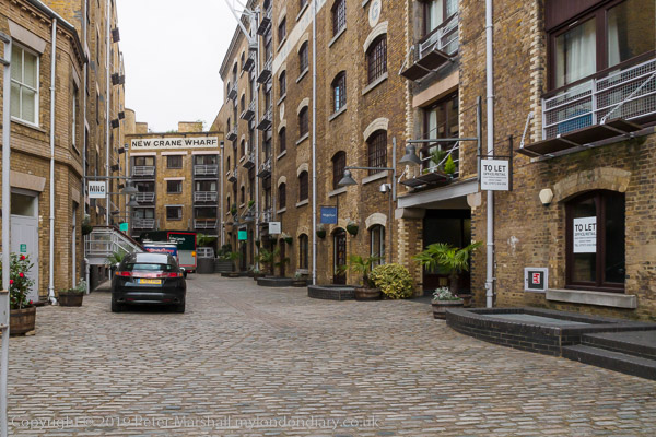
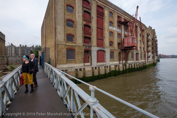
I’d made photographs here in the 1980s, and there were one or two that I’d hoped I would be able to fix the locations more precisely. It wasn’t easy as vitually everything between Wapping High Street and the river has been rebuilt with expensive riverside flats. New Crane Wharf (above) was still recognisable as here the old buildings had been converted.

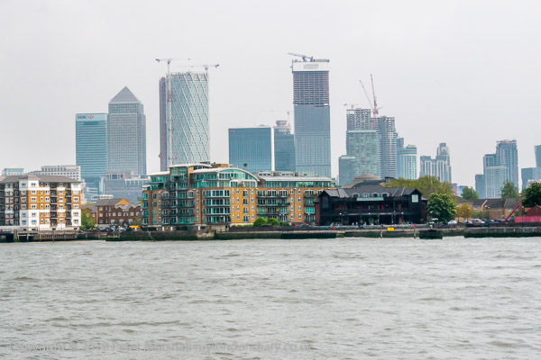
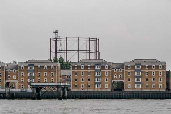
The Thames sweeps around to the south to go around the Isle of Dogs, and from Wapping you can see Canary Wharf to the North of the River and the gasholder in Rotherhithe to the south – and both appear in photographs to be across the river.

You also see rather too much very pedestrian riverside architecture like the flats above. So little new building on the river bank has any architectural merit, all about maximising profit within the planning restrictions. It’s such a shame that the LDDC didn’t have higher aspirations for its control of the redevelopment of docklands.

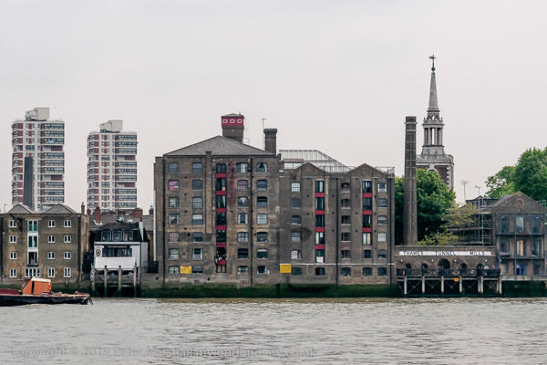
Relatively little of the old riverside survives here, and Tunnel Mills and the other buildings at Rotherhithe are one very welcome exception. There are parts of the north bank too where some of the better warehouses have been saved, converted into expensive flats.

It was good also to be able to walk out onto Tunnel Pier, where I met two old friends also taking advantage of the opportunity.

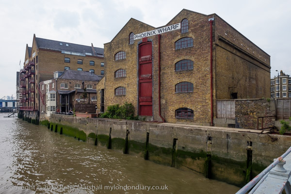
And though the Captain Kidd pub to the left of Phoenix Wharf is relatively modern, dating from the 1880s, like many Sam Smith’s pubs it is a sensitive conversion of an old building, Sun Wharf, which along with Swan Wharf (now renamed Phoenix Wharf) and St John’s F & G Wharf at left were owned or leased by W H J Alexander and Company, who as well as wharfingers dealing in a wide range of goods including coffee, dried fruit, gum and bales of Australian wool, also used these premises to repair their tugs. Swan Wharf I think is the oldest of these buildings, dating from the 1840s and possibly designed by Sidney Smirke.

More pictures at Wapping and the Thames .


All photographs on this and my other sites, unless otherwise stated, are taken by and copyright of Peter Marshall, and are available for reproduction or can be bought as prints.

There are no adverts on this site and it receives no sponsorship, and I like to keep it that way. But it does take a considerable amount of my time and thought, and if you enjoy reading it, please share on social media.
And small donations via Paypal – perhaps the cost of a beer – would be appreciated.