Tollington to Holloway – 1990

Tollington to Holloway continues my walk on Sunday February 11th 1990 which began at Kings Cross with the post Kings Cross and Pentonville 1990. The previous post was More from Tollington Park – 1990.

House, Tollington Way, Finsbury Park, Islington, 1990, 90-2d-56
House, 1A, Cornwallis Rd, Finsbury Park, Islington, 1990, 90-2d-56

This 3 storey detached house on Cornwallis Road, just a few yards down from Tollington Way, attracted my attention for its unusual decoration above what seemed a very ordinary door and window. According to Streets With a Story the street was developed in three periods as Shadwell Road, Esher Villas and Cornwallis Road in 1863, 1879 and 1885. This house probably dates from the latter part of that development but I’ve found nothing about it on-line

Royal Northern Hospital, Tollington Way, Holloway, Islington, 1990, 90-2d-42

The Royal Northern Hospital was founded in York Rd (York Way) in 1856 at his own expense by a surgeon who had been sacked from University College Hospital for smacking a patient’s bottom. The hospital provided free services for North London’s Poor as well as treating railway workers. But the railway bought the house and they had to move, using several properties in the area. Finally it got is own home and the Great Northern Central Hospital opened on Holloway Road in 1888, changing its name to the Royal Northern Hospital in 1921 and expanding to Tollington Way in the 1930s. It merged with the Whittington Hospital in 1963. The facade of the main building has been retained on Holloway Rd and the building is the Northern Medical Centre

Holloway Rd, Holloway, Islington, 1990, 90-2d-43

This picture was made from Tollington Way looking to the rather grand Italianate terraced villas on the opposite side of Holloway Road, Belgrave Terrace. They were locally listed in 1978. At left is The Cock Tavern at 596 Holloway Road. The pub was built in the 1880s and in the 2000s became a live music venue and bar, now Nambucca. Damaged by fire in December 2008 it reopened in 2010 and was refurbished in 2014 only to close in 2022 but unexpectedly reopen in 2024.

VICTORY TO THE IRA, Landseer Rd, Holloway, Islington, 1990, 90-2d-46

Holloway is one of the more densely populated areas of London with a very multicultural population including many Irish among its residents, and among them a significant number who supported the Irish struggle against the English occupiers in Northern Ireland. In 1990 we were in the middle of active attacks by the Provisional Irish Republican Army (IRA) on targets in London – the following year they attacked Downing Street using mortar shells and in 1992 a powerful bomb at the Baltic Exchange destroyed it and other buildings in the City of London, following this in 1993 with another bomb in Bishopsgate.

The street was named after the animal painter and sculptor Sir Edwin Landseer, best known now for the lions at the base of Nelson’s column. He became a ‘national treasure‘ and his death in 1873 gave rise to mourning across the nation and large crowds lined the streets as his funeral cortège made its way to St Paul’s Cathedral. Probably the street dates from around then.

W Wooley, Egg & Butter Merchant, 541, Holloway Rd, Holloway, Islington, 1990, 90-2d-31

The building is still there on Holloway Road, but sadly is no longer an Egg & Butter Merchant and has a new shopfront – and a bus shelter on the pavement in front of it.

Tollington to Holloway - 1990
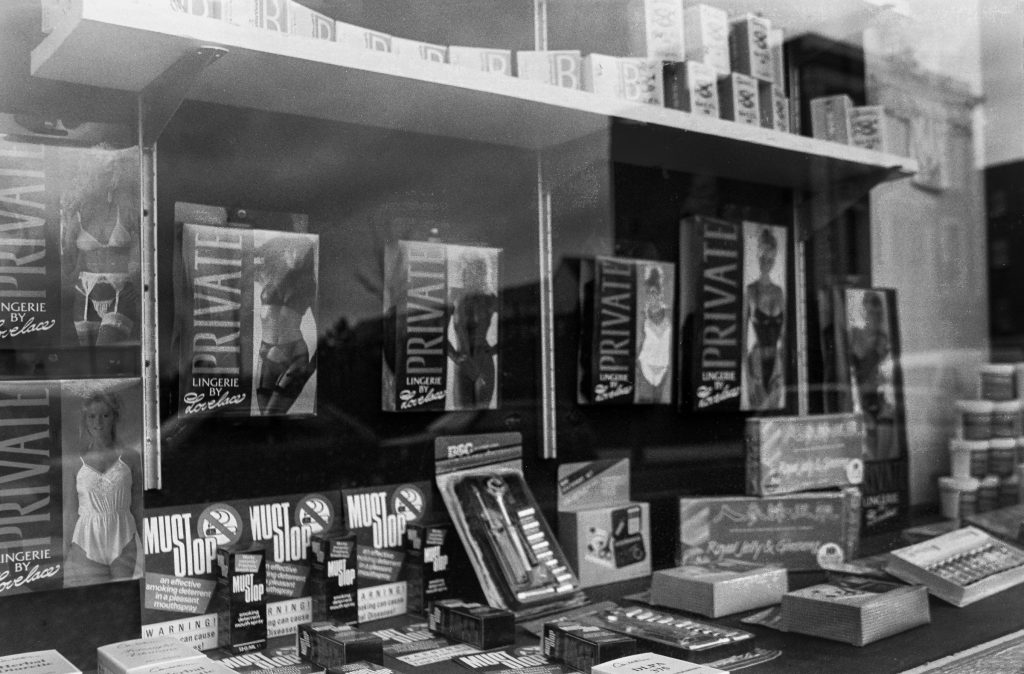
Lingerie, Stop Smoking, Royal Jelly & Ginseng, Holloway Rd, Holloway, Islington, 1990, 90-2d-32

As I made my way to the station at the end of my walk I could not resist this shop window with a rather strange mix of products including those listed and some rather strange health supplements. I only stopped long enough to take a picture and wasn’t tempted to buy anything.

My next walk a week later was also in North London and will be the subject of a later post.


FlickrFacebookMy London DiaryHull PhotosLea ValleyParis
London’s Industrial HeritageLondon Photos

All photographs on this page are copyright © Peter Marshall.
Contact me to buy prints or licence to reproduce.


More City of London Panoramas – 1994

More City of London Panoramas: This is the final set of picturesI’ll post from those I made while working on a personal project on the City of London in July 1994. Of course I took many which I’ve not digitised, spending several days walking the City and making over 300 exposures. The camera I used makes negatives on standard 35mm film which are wider than normal and a ’36 exposure’ film only gets around 20 or 21 panoramic frames. Film loading is also trickier as the film has to go around a curve.

Each exposure took a few minutes to select a viewpoint, set up my tripod, level the camera, use a handheld lightmeter to check exposure and finally press the cable release. Most of those not uploaded are similar to those I have posted with just minor changes to the view.

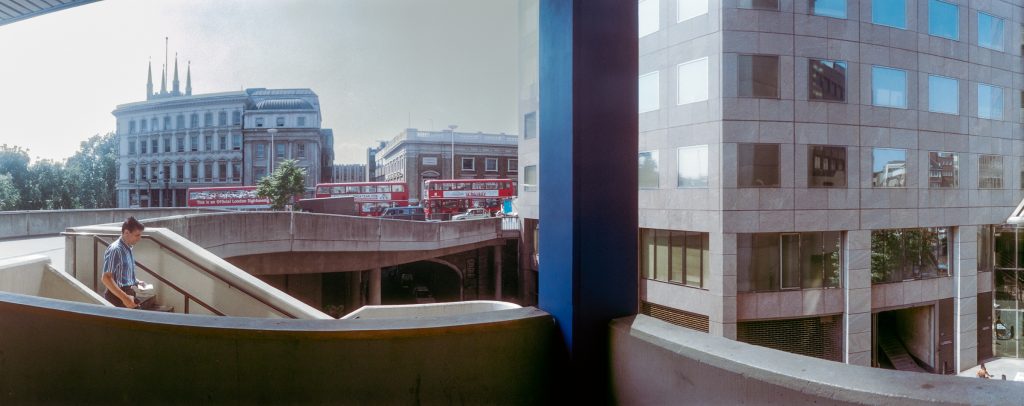
London Bridge Walk, Tooley St, Borough High St, Southwark, 1994, 94-711-52

Not quite in the City, but made as I made my way from London Bridge Station to London Bridge along London Bridge Walk. The road in the background is Borough High Street which leads on to London Bridge and the City boundary is in the middle of the river. You can just see the pinnacles on the top of the tower of Southwark Cathedral.

After the operation of the Waterloo & City underground line from Network South East to London Underground in April 1994 I could no longer use my ‘London Terminals’ ticket on this route, and my cheapest journey became to go to London Bridge on this and walk across to the City.

This is one of a few pictures I had digitised but missed when I was uploading these images to Flickr.

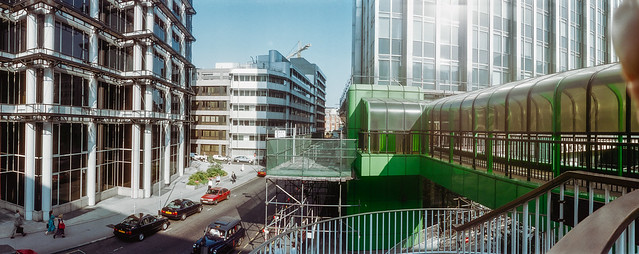
High Walk, Wood St, City, 1994, 94-713-42

Another exposure from the highwalk at Wood Street, leading south along the east side of the street away from London Wall. In the centre of the picture is the City of London Police Headquarters, with two white police vans at bottom right. Steps lead down from the walkway to Wood Street but the highwalk also continued straight on at extreme left – though with more steps.

In the centre of Wood Street at right is the tower of St Alban Wood Street. The medieval church was destroyed in the Great Fire and rebuilt by Sir Christopher Wren. The church was largely destroyed in the Blitz in 1940. The tower remained and was Grade II* listed in 1950 and is now a private house; the remains of the rest of the church were demolished in 1965.

Lower Thames St, King William St, City, 1994, 94-711-12

Again on my way from London Bridge Station to the centre of the City, this is made from where London Bridge joins to King William Street and goes across Lower Thames Street. You can see a highwalk bridge going across Lower Thames street a couple of hundred yards to the east, still there in 2025.

Until around 1970 Thames Street was a fairly narrow street, just wide enough to allow a single lane of traffic in both directions. It was then turned into a major road and divided at London Bridge into Lower and Upper Thames Street. At the left you can clearly see where older buildings were cut through to widen the road.

Bank Junction, City, 1994, 94-712-33

The heart of the City. I made the picture close to the corner of Mansion House Street and Princes Street with the Underground entrance on the corner. At left is a corner of the Bank of England and the main modern building towering above it is the Stock Exchange Tower, home to the Stock Exchange until 2004.

Towards the centre is the Royal Exchange, I think then still home to the International Financial Futures Exchange rather than just an upmarket shopping mall. Two buildings full of banks and insurance companies book-end Hawksmoor’s St Mary Woolnuth and at the extreme right is the edge of the Mansion House with a gilded lamp on its steps.

Milton Court, Silk Street, City, 1994, 94-713-21

Another section of highwalks ran from close to Moorgate Station to the Barbican Estate and these last four pictures show sections of this, which could also be accessed from Ropemaker Street. This northern section has now been lost.

Milton Court was designed by Chamberlin, Powell & Bon and built as a part of the Barbican development in 1959 for various City services – “a fire station, Coroner’s Court, mortuary, office of weights and measures and a civil defence school.”

It was arguably London’s most outstanding single post-war building and English Heritage wanted to list it in 2001, but the government’s Department of Culture, Media and Sport objected and in 2007 Secretary of State James Purnell granted it immunity from listing. In a sad act of cultural vandalism this remarkable building was demolished in 2008.

Milton Court, Silk Street, City, 1994, 94-713-12

The building which replaced Milton Court was also given the same name but is a much more bland modern structure. The bridge which linked to the northern section of highwalk disappeared.

The new 115m tall Milton Court is described on its builders Sir Robert McAlpine web site: “Climbing to 36 storeys, Milton Court redefines luxury living in the Square Mile. In addition to a graceful residential tower, the development is home to a spectacular new annexe to the Guildhall School of Music & Drama.” But to me it looks like just another tall city office block.

Highwalk, Ropemaker St, City, 1994, 94-715-52

This enclosed section of highwalk ran from Ropemaker Street to the bridge across Silk Street to the Speed Highwalk still there along the north side of Speed House.

Ropemaker St, Islington, City, 1994, 94-715-32

Remarkably I think none of the buildings in this picture looking east along Ropemaker Street has ssurvived. Even the building at left, Ropemaker Place, a 60m high block which I photographed while it was being built in 1986 and was completed in 1987 and which I thought was one of the more attractive modern buildings in (or rather a few feet outside) didn’t last long and was demolished only 18 years later in 2005.

More colour from 1994 in later posts.


FlickrFacebookMy London DiaryHull PhotosLea ValleyParis
London’s Industrial HeritageLondon Photos

All photographs on this page are copyright © Peter Marshall.
Contact me to buy prints or licence to reproduce.


More from Tollington Park – 1990

More from Tollington Park – 1990 continues my walk which began at Kings Cross on Sunday February 11th 1990 with the post Kings Cross and Pentonville 1990. The previous post was Fonthill & Tollington.

House, Tollington Park, Finsbury Park, Islington, 1990, 90-2c-12

Tollington is a district whose name dates back at lease into Saxon times. According to Eric A Willats’ ‘Streets With A Story‘, from which much of the information in this post comes, “It was spelt ‘Tollandune’ in the Anglo-Saxon Charters meaning the hill or pasture of Tolla. ‘Tolentone’ meant a pannage for hogs, a place of beechwood and mast. This area and Holloway were all then part of the Great Forest of Middlesex. It
had various spellings Tolesdone, Tolyndon, Tallingdon and Tallington
.”

Modern development of the area, then farmland, began early in the 19th century; “About 1818-1820 ‘a pretty range of villa residences were erected in the Italian style by Mr. Duerdin, with stabling and offices attached, from the designs of Messrs. Gough and Roumieu.’” These are now 96, 102, 106 and 110 Tollington Park.

House, Tollington Park, Finsbury Park, Islington, 1990, 90-2c-13

Like many other early and mid-19th century developments the villas were first given their own distinct subsidiary names and only became numbers in ‘Tollington Park’ in 1871, Willats gives the following details:

After 1871 subsidiary names were abolished, e.g., Belmont Terrace became nos2-6, Birnam Villas 8-10,St Marks Villas 16-22, Claremont Villas 24-36, Duerdin Villas 44-56, Fonthill Villas 60-70, Syddall Villas 59, Syddall Terrace 63-73, Regina Villas 89-101, Shimpling Place by 1882 nos15-155 Upper Tollington Park, Harrington Grove 1848/9 became after 1894 47 to 67 and 52 to 70 CHARTERIS ROAD. Nos96 to 108 have been attributed to Gough & Roumieu, built 1839-40

House, 53, Tollington Park, Finsbury Park, Islington, 1990, 90-2c-14

This corner house has been significantly modernised but retains its tall archway and fits in well with the adjoining houses out of picture to the left. It doesn’t get a mention on the fine map of ‘Historic Tollington’ which was “created by the incredibly vibrant Tollington Park Action Group in 1994.” As well as the plan of the streets this contains informative annotation on 26 sites in the area and would have been very useful to me as a guide to the area which I photographed four years before the map was made.

House, 20A, Turle Rd, Finsbury Park, Islington, 1990, 90-2c-15

Willats suggests the road was “Probably named after a John Turle of no.11 Tollington Park who was at that address in 1830 and in 1833.”

George Orwell School, Turle Rd, Finsbury Park, Islington, 1990, 90-2d-65

The former Tollington Park School first opened in 1886. It gained some new buildings to add to its Victorian main block in 1930 but these were demolished by bombing in 1940. I think my picture shows the new extension built in 1955.

It was renamed by the Inner London Education Authority in 1981 after Eric Arthur Blair, better known as George Orwell, in 1981. He had lived not far away at 27b Canonbury Square from 1944-7. The name of this ‘secondary modern’ school was changed when it was merged with Archway Secondary School and it disappeared in 1999 following a damning Ofsted inspection of all Islington’s schools, re-emerging as Islington Arts and Media School.

The school’s most famous former pupil is photographer Don McCullen who was born and grew up in Finsbury Park nearby.

St Marks, church, Church Hall, Moray Rd, Finsbury Park, Islington, 1990, 90-2d-53

Work began on building the church in 1853; its architect was Alexander Dick Gough (1804-71) who lived at 4 Tollington Park. He was a pupil of Benjamin Dean Wyatt and for some years worked in partnership with Robert Lewis Roumieu; their work together in North London included the Islington Literary and Scientific Institution (now the Almeida Theatre), the rebuilding of the Norman St Pancras Old Church and several Italianate villas in Tollington Park mentioned above.

After their partnership was dissolved in 1848, Gough designed or redesigned over a dozen churches in North London and elsewhere, many now demolished, along with other buildings. St Mark’s required some structural alterations in 1884 and was renovated in 1904.

Tollington Court, Tollington Place, Finsbury Park, Islington, 1990, 90-2d-54

These 1938 flats are on the corner of Tollington Place and Tollington Park and I was standing a few yards down Moray Road to make this picture, with the square and fluted round pillars of St Mark’s Mansions, 60 Tollington Park, at the left. This building is locally listed as a semi-detached Italianate villa dating from around 1850.

St Marks Mansions, Tollington Park, Finsbury Park, Islington, 1990, 90-2d-55

This shows the neighbouring semi-detached villa of St Mark’s Mansions and the poor decorative state of many of the buildings like this long converted into flats in Tollington Park. The area has been considerably gentrified since 1990 and it is hard to believe the state of the properties then when you look at them now.

See what Tollington looked like in the 60’s & 70’s has a collection of pictures by Leslie William Blake taken before the area had begun to receive any real investment following extensive bomb damage in the war. The article states “it wasn’t until the late Sixties that any real investment began” to come into the area, and my pictures from 1990 show that there was still much to do.

More pictures from my walk in a later post.


FlickrFacebookMy London DiaryHull PhotosLea ValleyParis
London’s Industrial HeritageLondon Photos

All photographs on this page are copyright © Peter Marshall.
Contact me to buy prints or licence to reproduce.


Fonthill & Tollington – 1990

Fonthill & Tollington continues my walk on Sunday February 11th 1990 which began at Kings Cross with the post Kings Cross and Pentonville 1990. The previous post was Caledonian Road, Barnsbury & Lower Holloway – 1990.

Tower House, 149, Fonthill Rd, Finsbury Park, Islington, 1990, 90-2c-32

The Tower House it at the south end of a late Victorian terrace at 141-9 Fonthill Road close to the junction with Seven Sisters Road. This was the factory and showroom for Witton, Witton & Co. In an advertisement in Musical Opinion & Music Trade Review they describe it as ‘BRITAIN’S FINEST FACTORY’ producing ‘”THE IDEAL BRITISH PIANO” Specially made for Variable Climates’. According to the Pianoforte-makers in England web site the company was formed in 1874, although earlier Wittons had made pianos from 1838. They held two patents related to pianos. The name continued in use after production went abroad in the 1930s. Their grand pianos are said to be not well made.

By 1990 the tower had lost its top floor topped by a cupola. Like much of Fonthill Road the building was mainly in use by clothing manufacturers and wholesalers in 1990.

Goodwin St, Finsbury Park, Islington, 1990, 90-2c-35

The 3 storey house in this picture is still present on Goodwin Street, a turning off Fonthill Road which now leads through City North House to Finsbury Park Station. This is 11 Goodwin St, owned by the Trustees of Peace News and the home of CND, the Campaign Against Arms Trade as the hanging sign above the double door indicates, along with various other groups. I think the right hand door was number 13, though the numbering around here seems rather random.

Shops, Fonthill Rd, Finsbury Park, Islington, 1990, 90-2c-36

The rather strangely staggered roofline is still there at 138 Fonthill Road and all the shops are still in the clothing trade, though I think all the names are changed. Photographer Don McCullin grew up in the area in the 1940s and described the area as “a battlefield” and later he was to photograph on many real ones, including in Cyprus.

It was the Cyprus emergency with the UK fighting EOKA in the the late fifties and the later war between Greeks and Turks that led to many Cypriots to come to live in North London – and a number of them set up clothing factories and wholesale businesses here – and others from Turkey, the Caribbean and Africa came too. At first shops here were simply wholesale, but then many began to open on Saturdays for retail sales, and the street was crowded with people – mainly women – buying real bargains.

Fonthill Metal Co, Fonthill Rd, Finsbury Park, Islington, 1990, 90-2c-21

I don’t think any trace remains of the Fonthill Metal Co or the garage next door on Fonthill Road which were almost at the end of Fonthill Road close to Tollington Park. There used to be many similar small scrap metal dealers who would pay cash on the spot for non-ferrous metals – Copper, Brass, Lead, Zinc and Ali – aluminium.

BRAIZERY here means copper pipes and other material which has been soldered and so contains small amounts of other metals, particularly tin and lead. If you have a decent load of this you can probably get around £6 a kilo for it – but no longer on Fonthill Road.

Velvet Touch, Fonthill Rd, Finsbury Park, Islington, 1990, 90-2c-22

Later retail clothes shops elsewhere in the country found they could buy clothing cheaper abroad than garments made in the UK, and manufacturing here started to fall away. Slowly more and more wholesalers welcomed retail customers and many new wholly retail shops opened.

More recently the retail trade has fallen away too as the area becomes increasingly gentrified. Most of the clothes still on sale are now made abroad, particularly in Turkey.

Velvet Touch at 1 Fonthill Road was at the far end to the other clothing manufacturers, wholesalers and importers and although you can still read that line of their shopfront, (rather faded now) their name and the large sign on the side wall are long gone and I think the building is now residential. The very small window on the first floor is still bricked up.

St Mellitus, RC, Church, Tollington Park, Finsbury Park, Islington,, 1990, 90-2c-23

Built as the New Court Chapel in 1871 by Congregationalists from New Court, Carey St, Lincoln’s Inn Field after their chapel had been demolished to build the Royal Courts of Justice.

The Neo-classical church, designed by C G Searle seated 1,340 and in the early years was often full in the early years, but after the war congregations dropped away. It was sold to the Catholic Church in 1959, becoming St Mellitus RC Church. St Mellitus was the first Bishop of London in 604CE and later in 619CE became Archbishop of Canterbury.

House, Tollington Park, Finsbury Park, Islington, 1990, 90-2c-24

Tollington Park was one of the first streets in this northern part of Islington in Finsbury Park (estate agents like to call it Stroud Green, but that seems rather a stretch too far) to be laid out and its grand semi-detached villas date from the 1830’s and 40’s.

Before that cows had grazed its fields to supply milk to London across north Islington which had what was claimed to be the largest dairy farm in the country, run by Welsh dairy farmer Richard Laycock.

By WW2 the area had deteriorated and become a poor working-class area. It was heavily bombed in WW2 and much still remained in a mess twenty years later. By the 1970s it was home to many migrants from across the world, including “Welsh, Irish, Jamaican, and others from all over the world.”

House, Tollington Park, Finsbury Park, Islington, 1990, 90-2c-26

Many of the damaged properties and some others were demolished in 1970 to form a park, Wray Crescent, and gentrification of the area set in. The Friends of Wray Crescent history page contains a number of pictures of Tollington in the 1960s and 1970s, taken by Leslie William Blake when “local campaigners and the Tollington Park Action Group began to fight to preserve some of the buildings, including the creation of the local conservation zone.”

Houses like those in my picture are now all or almost all a number of flats. Only 4 houses in Tollington Park are Grade II listed (along with the two churches) but many are locally listed including these two at 104 and 106, thought to have been built in 1840.

More from this walk to follow.


FlickrFacebookMy London DiaryHull PhotosLea ValleyParis
London’s Industrial HeritageLondon Photos

All photographs on this page are copyright © Peter Marshall.
Contact me to buy prints or licence to reproduce.


Caledonian Road, Barnsbury & Lower Holloway – 1990

Caledonian Road, Barnsbury & Lower Holloway continues my walk which began at Kings Cross on Sunday February 11th 1990 with the Kings Cross and Pentonville 1990. The previous post to this was Battlebridge, Canalside and Barnsbury – 1990.

Used furniture, Caledonian Rd, Barnsbury, Islington, 1990, 90-2c-54

From Thornhill Square I returned along Bridgeman Road to Caledonian Road, both sides of which are here lined with shops. Almost immediately on the east side of the road I saw this shop selling used furniture (I think it is now an estate agents) with the pavement in front having some of its stock – stacking tubular chairs – in front of a crude partition, at its left a phone card box and in front of that some cabinets used to support the shop’s sign.

The pavements along here are now cleared of clutter.

Sandwich Bar, Fire Escape Specialists, Caledonian Rd, Barnsbury, Islington, 1990, 90-2c-56

R Bleasdale & Co Ltd, Fire Escape Specialists had a splendid gate advertising their Victorian Metal Design. This was at 394 Caledonian Road where a similar business, The Cast Iron Shop, remained until around 2020, though the gate was long gone, together with the Sandwich Bar.

The sandwich shop also interested me with it with its striped awning and notices, incluind ‘DELICIOUS HOT SALT BEEF’ though I was unable to try it as like most shops then it was closed on Sundays.

Chinese Chef, Restaurant, Caledonian Rd, Lower Holloway, Islington, 1990, 90-2c-42

Another window I found of interest, divided into two halgs one of much had four shleves each with two spider plants and above them a net curtain. The left half mixes the reflection of the buildings opposite with the menu, a light fitting, plants and cans of soft drink under a counter inside.

Chinese Chef was on the corner with Roman Way until around 2019

Romeo Trading Co Ltd, Roman Way, Lower Holloway, Islington, 1990, 90-2c-44

I walked a few yards down Roman Way to photograph Romeo Trading Co Ltd, making several pictures both in black and white and in colour. I think this is the company founded in 1941 specialising in military surplus clothing and now operating online and in “an impressive 85,000 square foot warehouse“, Romeo House, in Tottenham.

Their former site and more of the street is now occupied by a large block of flats, Roman Court.

Mallet Porter & Dowd, Caledonian Rd, Lower Holloway, Islington, 1990, 90-2c-45

From Roman Way I photographerd Mallet Porter & Dowd on the west side of Caldedonina Road at 465 made hard-wearing fabric from horse-hair at their premises close to the Metropolitan Cattle Market, used for uniforms and textile products. This building inscribed with their name dates from 1874.

It was disgracefully converted into student housing for University College London by Mortar Developments in 2015, in a development that retained the facade a few feet in front of an unsympathetic modern development to the detriment of both. It was a worthy winner of the 2013 v awarded by Building Design for the year’s worst building. Islington Council had rejected the scheme but this was overturned on appeal.

Salvo, Caledonian Rd, Lower Holloway, Islington, 1990, 90-2c-46

Salvo C F S Ltd, Wine & Provision Importers occupied the building immediately south of Mallet Porter & Dowd until it was demolished around 2011. The company was set up by Salvatore Cumbo who owned a pizzeria in London to import Italian food and drink as wholesalers. The company moved here in 1975, and moved out in 2011 to larger premises in Hertfordshire.

The doorway between the two buildings had the number 465 and so was to the Mallet Porter & Dowd building; the free-standing ‘facade’ rather oddly retains its right hand edge of this door. It perhaps led to the offices and the building also had the wider doorway at the right of the picture.

At this point I think I decided to take a little rest and got on the tube. I’d planned to get to Finsbury Park and time was running out. The next in this series of posts will begin with tthe next frame I made which was in Finsbury Park.


FlickrFacebookMy London DiaryHull PhotosLea ValleyParis
London’s Industrial HeritageLondon Photos

All photographs on this page are copyright © Peter Marshall.
Contact me to buy prints or licence to reproduce.


Battlebridge, Canalside and Barnsbury – 1990

Battlebridge, Canalside and Barnsbury continues my walk which began at Kings Cross on Sunday February 11th 1990 with the post Kings Cross and Pentonville 1990.

Battlebridge Basin, Pentonville, Islington, 1990, 90-2b-11

Battlebridge Basin on the Regent’s Canal was opened at the same time as the Camden Town to Limehouse stretch of the canal in 1820, though the buildings around it took a couple of years longer to complete. In 1815 the landowner William Horsefall contracted with the canal company to allow them to dump the soil extracted from the Islington Tunnel a short distance away on his land, and he used this to form the basin.

It seems odd that you should need earth to form a basin, but it was needed to raise the ground level around it as part of the 480ft by 155ft basin is above the level of the streets around. Horsefall got an Act of Parliament to fill the basin with water from the canal and by 1822 it was surrounded by industrial premises, including timber yards. Among later occupants were W J Plaistowe & Co, jam, marmalade and preserve makers, here until 1926, and at Albert Wharf on the northeast corner were Cooper & Sewell (c1847-1880) and J Mowlem & Co (c1880-1922).

The best-known building on the basin was the warehouse built around 1860 by ice-cream maker Carlo Gatti to store ice brought from Norway, which since 1992 houses the London Canal Museum. In a Key Stage 2 teaching resource on their site is an excellent plan showing the uses of the different areas around the basin in the late 19th century.

Unlike other canal basins in London this was privately owned, known first of all as Horsefall Basin, then Maiden Lane Basin before taking its current name – the old name for the Kings Cross area, which had a bridge over the River Fleet. There seems to be no agreement as to which battle this was named after but few beleive the popular legend it was fought by Boudicea. In 1978 a group of boat owners came together so set up moorings here which over the years since have developed into a substantial marina.

Mercantile House, All Saints St, Pentonville, Islington, 1990, 90-2b-14

My previous post on this walk showed an overall picture of Mercantile House and gave a little of its history. In 1990 the whole site was undergoing redevelopment as you can see in pictures below. Mercantile House was retained.

All Saints St, Pentonville, Islington, 1990, 90-2b-13

I photographed Bartlett Ltd, Export Packers in 1979 from the canal towpath and wrote a little about Battlebridge Basin and Bartlett’s works then and wrote:

Although many of the canal-side buildings in the area have been replaced, a warehouse on the basin of Bartlett Export Packers survives in greatly altered form as Albert Dock. The works buildings in this picture, at the end of New Wharf Road, have been replaced by those of Ice Wharf, three blocks with 94 apartments in a highly regulated private development with 24 hour concierge service and a private, gated underground parking space where a 2 bed flat overlooking the canal could be yours for only £1,195,000.

Demolition of the buildings on All Saints Street whichg meets New Wharf Road at its west end provided me this view of part of Bartletts from here.

Regent's Canal, View West, from, Caledonian Rd, Pentonville, Islington, 90-2c-64
Regent’s Canal, View West, from, Caledonian Rd, Pentonville, Islington, 90-2c-64

From Thornhill Bridge on the Caledonian Road over the canal I could see the cleared development site and, in the distance St Pancras Hotel, the Post Office Tower and other buildings. At the left are the back of buildings on Caledonian Rd.

Regent's Canal, View West, from, Caledonian Rd, Pentonville, Islington, 1990, 90-2c-65
Regent’s Canal, View West, from, Caledonian Rd, Pentonville, Islington, 1990, 90-2c-65

A second view west from Thornhill Bridge includes Bartlett’s water tank and canalside buildings.

Thornhill Crescent, Barnsbury, Islington, 1990, 90-2c-52

I walked on north up Caledonian Road to Thornhill Crescent at the northern end of Thornhill Square, once of the well-known Barnsbury Squares, though it certainly is not square – together they are more of an oval, narrowing towards the southern end. Wikipedia calls it “an unusual large ovoid ellipse“.

Much of the land around here was owned by the Thornhill family who had come from Yorkshire and let to dairy farmers. George Thornhill began Thornhill Square in 1847, and Samuel Pocock, one of those rich farmers began Thronhill Crescent around 1849.

Lived in at first by prosperous middle class households, the area became run-down by the middle of the last century with many properties in multiple occupation and high levels of street crime. But Islington became fashionable in the 1960 and 70s and gentrification led many of those living to purchase the freeholds and the area went upmarket. Some flats now sell for over a million pounds and entire houses over two million.

More from Barnsbury in the next post in this series.


FlickrFacebookMy London DiaryHull PhotosLea ValleyParis
London’s Industrial HeritageLondon Photos

All photographs on this page are copyright © Peter Marshall.
Contact me to buy prints or licence to reproduce.


Carnival, Racist Deportations & more Naked Cyclists – 2009

Carnival, Racist Deportations & more Naked Cyclists: I began work on Saturday 13 June 2009 photographing a carnival procession in Carshalton in the south of London, travelled to Islington in north London for a protest against Britain’s racist and inhuman immigration policies and finally covered the uncovered cyclists taking part in the 2009 London World Naked Bike Ride, photographing the preparations in Hyde Park ad the start of the ride there and then on the ride at Waterloo and in the West End.


Carshalton Carnival Procession – St Helier – Carshalton

Carnival, Racist Deportations & more Naked Cyclists - 2009
Sutton’s May Queen 2009 came to look at my cameras

My account of this event on My London Diary begins with a slightly unkind description “of the St Helier estate, a huge sprawling area built by the LCC 1930 to a kind of debased Garden City plan almost entirely without the charm of those earlier developments on what had previously mainly been the lavender fields of Mitcham.”

Carnival, Racist Deportations & more Naked Cyclists - 2009

The procession began next to the “St Helier Hospital [built] in the modern style of the 30s, facing the imaginatively named St Helier Open Space” outside the Sutton Arena leisure centre and as usual I found the more interesting pictures were those I took there rather than on long procession to Carshalton where it was to end at a fair in Carshalton Park.

Carnival, Racist Deportations & more Naked Cyclists - 2009

I’d come to the carnival largely because I was then working on a project on London’s May Queens, with several groups of them from across south London taking part in the procession, along with various other local organisations. And a Dalek and others in fancy dress.

Carnival, Racist Deportations & more Naked Cyclists - 2009

The Rotary had brought their Father Christmas coming out unseasonably from the chimney of a small four-wheeled house towed behind a car at the rear of the procession. He’d been there too when I photographed the carnival previously in 2004.

It was a long an hot trek to Carshalton from St Helier, and the procession paused at Carshalton College for a break. I’d walked enough and made my way to the station missing the rest of the event and the funfair in Carshalton Park.

Carshalton Carnival Procession.


Speak out against Racism and Deportations – Angel, Islington

Britain’s major political parties at the prompting of our mainstream press have long promoted myths about migrants and asylum seekers, the more rabid of our tabloids in particular promoting the views of clearly racist columnists who publish stories about them getting homes and huge benefits, depriving the working class of housing, pushing down wages, taking “our jobs“, making it impossible to see doctors and more.

Nothing could of course be further from the truth. It’s the greed of the wealthy and government policies that have led to these problems – and without the migrants we would be in a considerably worse position. It’s something that is glaringly obvious when we need to make use of the NHS which would have collapsed entirely without them, but also in other areas. Demonising migrants is a deliberate policy divert public attention and anger away from the real problem of our class-based society. Divide and rule by our rulers,

Most of those who settle here from abroad want nothing more than to work and contribute to our society, though we make it hard for many of them to do so. They want a better life, particularly for their children and often work long hours for it. Migrant workers who clean offices are often more qualified than those who work in them – but their qualifications are not recognised here, and asylum seekers are unable to work except in the illegal economy.

Some facts:

  • Over a quarter of NHS doctors were born abroad (and others are the sons and daughters of migrants);
  • Immigrants are 60% less likely to claim benefits than people born in Britain;
  • Studies sho immigration has no significant effect on overall employment, or on unemployment of those born in Britain.

This campaigning protest in a busy shopping area outside one of London’s busier Underground Stations was organised by the Revolutionary Communist Group and was also part of a campaign by the Suarez family to prevent the deportation of John Freddy Suarez Santander, a 21 year-old father with a 3 year-old son. He came here from Colombia when he was six and grew up here. As a teenager he committed an offence and served 7 months in a young offenders institution.

Two years after he had served his sentence, the New Labour government passed a law to deport all immigrants with a criminal record, and an order was made for him to be sent back to Colombia, where he has no remaining relatives. His case in 2009 was still being considered at the European Court of Human Rights. The ECHR generally asserts that juvenile offences should not be seen as a part of a criminal record, but the Home Office decided the month before this protest to deport him anyway, and this was only stopped by his family going to the airport.

Speak out against Racism & Deportations


World Naked Bike Ride – London

I’ve written rather often about this event, intended as a protest against the domination of our lives by ‘car culture’ which has resulted in our towns and cities and transport networks being designed around the priorities of motorists and road transport rather than us as pedestrians and cyclists – and to serve the interests of the companies that make cars and lorries. And it has resulted in illegal levels of pollution causing massive health problems.

Although it’s certainly an eye-catching event, it isn’t always very clear why it is taking place to those standing on the pavements, gazint at it in amazement, laughing and recording it on their phones. It’s probably good for our tourist industry, though I rather think London has too many tourists anyway, particularly as I struggle to walk over Westminster Bridge.

Heres one paragraph of what I wrote in 2009 – you can read the rest on My London Diary.

Some riders did have slogans on their bodies, mainly about oil and traffic, and some bikes carried A4 posters reading REAL RIGHTS FOR BIKE and CELEBRATE BODY FREEDOM or had flags stating ‘CURB CAR CULTURE’ which made clear the purpose of the event to the careful onlooker, but for most people it seemed simply a spectacle of naked or near-naked bodies. Though of course also a rare treat for any bicycle spotters among them.

I didn’t censor the pictures I put on line from the event though I’ve carefully selected those in this post. I think that there is nothing offensive about the naked human body but I included the following statement with the link to more pictures I posted then and which you can still see online.

Warning: these pictures show men and women with no clothes on. Do not click this link to more pictures if pictures of the naked human body may offend you.

Many more pictures at World Naked Bike Ride – London.


FlickrFacebookMy London DiaryHull PhotosLea ValleyParis
London’s Industrial HeritageLondon Photos

All photographs on this page are copyright © Peter Marshall.
Contact me to buy prints or licence to reproduce.


London’s Canal Walk: 2007

London’s Canal Walk: On Saturday 26th May 2007 I walked across London together with my wife and older son on canal towpaths from Mile End in the east to Old Oak Lane in the west, from where we made the short walk to Willesden Junction for a train towards home.

London's Canal Walk: 2007
There is a great deal of new building next to the Regents canal

I’d walked and cycled along many shorter sections of these canals before, but this was the first time I’d done the whole roughly 12 miles in a single stretch. Most of the way we kept to the towpaths, but there are two tunnels around which we had to detour on roads, and a few places where walking along a road was more convenient than using the tow path, particularly around Little Venice.

London's Canal Walk: 2007
The Hereford Union runs into the Regents Canal in Bethnal Green just beyone here

Probably the definitive book on English canals was written by a photographer, Eric de Maré, (1910 – 2002), one of a now largely forgotten generation of British photographers, and illustrated with many of his fine photographs, as well as some by others. He was one of the finest architectural photographers of the mid-20th century and also someone whose popular Penguin book ‘Photography’ published in 1957 introduced many of us to the history, techniques and aesthetics of the medium. Others since have looked better on the coffee table but have lacked his insight.

London's Canal Walk: 2007
By Cambridge Heath Road, Empress Coaches and the gas holders

de Maré and his first wife lived on a canal boat for some years and travelled around 600 miles along them while writing and taking the pictures for the book ‘The Canals of England’ published by Architectural Press in 1950 which remains the definitive publication on our canals, though in some obvious ways outdated. The canals – which had played an important part in the war effort – had been nationalised under the National Transport Act on 1st January 1948 and part of the book is an impassioned plea for the UK’s transport policies to be revised to update the system and make fuller use of our great canal heritage.

London's Canal Walk: 2007

But of course that didn’t happen, thanks to huge road transport lobby, and instead of canals similar to some in the continent we got motorways. The canals were encouraged to bring commercial traffic to an end, and with a few isolated examples most was finished by 1970 with the canals being given over to leisure use.

Not that de Maré was against leisure use and his work actively promoted this for many of England’s narrow and more rural canals as well as making an argument based on the commercial possibilities of schemes such as the ‘Cross or Four River Scheme’ proposed earlier by a 1906 Royal Commission for wide high volume commercial canals linking Bristol, Hull, Liverpool and London with the Midlands cities of Birmingham, Nottingham and Leicester.

London's Canal Walk: 2007

The book came out in a second edition in 1987 and copies of both are available reasonably priced secondhand – my copy of the first edition with a handwritten dedication from de Maré was at some point marked by a bookseller’s pencil for 6d but I think I paid just a little more. I can find no individual website showing more than a small handful of his pictures – though you can see many by searching for his images online.

It’s still interesting to walk along by the canals in London, and easy to do in smaller sections – or to add a little at either end should you want to and perhaps walk from Limehouse to Southall or Brentford. I didn’t write much about the walk in 2007, but I’ll end with what I did write back then – with the usual corrections.

On Saturday I accompanied Linda and Sam on a walk along some of London’s canals, from Mile End on the Regent’s Canal and along that to join the Grand Union Paddington Branch at ‘Little Venice’, and west on that to Willesden Junction.

When I first walked along the Regents Canal I had to climb over gates and fences to access most of it. The towpath was closed to install high voltage lines below it, but even the parts that were still theoretically open were often hard to find and gates were often locked. The public were perhaps tolerated, but not encouraged to walk along them.

Now everybody walks along them and there are those heritage direction posts and information boards that I’ve rather come to hate. And from this weekend, you no longer even theoretically need a licence to cycle the paths – though mine is still in my wallet, several years since I was last asked to show it.

Now, as walkers, the constant cycle traffic on some sections has become a nuisance. And although most cyclists obey the rules, riding carefully, ringing bells and where necessary giving way, we did have to jump for safety as one group chased madly after each other, racing with total disregard for safety.

But for the rain – the occasional shower at first, later settling in to a dense fine constant downpour, it would have been a pleasant walk.

Many more pictures on My London Diary


FlickrFacebookMy London DiaryHull PhotosLea ValleyParis
London’s Industrial HeritageLondon Photos

All photographs on this page are copyright © Peter Marshall.
Contact me to buy prints or licence to reproduce.


Jobs, Services, Education, Yemen, Rev Billy, Police Violence – 2009

Jobs, Services, Education, Yemen, Rev Billy, Police Violence: Saturday 23 May 2009 was another busy day for protests in London. I began with the March to Defend Jobs, Services and Education in North London, moved to Whitehall for a protest by Southern Yemenis calling for independence and met the The Reverend Billy and his ‘Life After Shopping’ Gospel choir for a performance in front of the gates of Downing St. Later I met the Rev again on a march against police violence prompted by the killing of Ian Tomlinson by a police officer at he G20 protest at the start of the month.


March to Defend Jobs, Services and Education – Highbury Fields to Archway

Jobs, Services, Education, Yemen, Rev Billy, Police Violence - 2009

The march by around 500 workers in Islington from Highbury Fields to Archway followed the loss of 1500 jobs in the area, including 550 mainly support workers from London Metropolitan University, 500 civil servants from Archway tower and more at City University, where adult education is under threat.

Jobs, Services, Education, Yemen, Rev Billy, Police Violence - 2009

It was supported by many local groups including the Islington National Union of Teachers, the Public & Commercial Services Union, London Metropolitan University Unison and the University and College Union. Among the speakers at the Archway rally were local MP Jeremy Corbyn and local trade union leaders.

Jobs, Services, Education, Yemen, Rev Billy, Police Violence - 2009

Education in the area has been particularly important in giving people who have missed out in various ways in their schooling a chance to gain qualifications, and the cuts threaten the future of many of these courses as well as the support such as nurseries which enable many mature students to continue education. Islington has the highest population density of any local authority in England and Wales and a third of its residents live in poverty – well above the London average.

March to Defend Jobs, Services & Education


Southern Yemenis Demonstrate For a Separate State – Downing St, Whitehall

Jobs, Services, Education, Yemen, Rev Billy, Police Violence - 2009

Southern Yemenis from the Southern Democratic Assembly (TAJ), based in London came to protest following protests in Aden the previous week on the 15th anniversary of the attempt by Southern Yemen to break away from the North which began the 1994 Civil War, a short but brutal conflict which ended in July 1994 with defeat for the South.

Southern Yemen, until 1967 the British protectorate of Aden, was granted independence and in 1969 became the People’s Democratic Republic of Yemen. Although a decision to unite with North Yemen – the Yemen Arab Republic – was made in principle in 1972 this only happened in 1990 when the Republic of Yemen was formed. South Yemen contains most of the reserves of oil and other resources and TAJ accuse the government of grabbing land and property and of human rights abuses.

Since 2004 the rise of the Houthis has dominated politics and armed conflict in Yemen with a full-scale civil war between them and a Saudi-led coalition backed by the US and the west since 2015.

Southern Yemenis Demonstrate


Rev Billy Performs at Downing St

“Officer, I can see you have a shopping problem”

The Reverend Billy and his ‘Life After Shopping’ Gospel choir from New York were busy in London today on their 2009 UK Shopocalypse Tour.

Police obviously had no idea of how to handle the Reverend and his green-robed choir when the came and gave a brief performance on the pavement in front of the tall gates with their armed guards.

As I wrote, ‘The Church of Life After Shopping believes that we need to “back away from the product” and resist the way that advertising and the media persuade us to live only thorough consuming corporate products, and get down to experiencing life directly. We can live more by consuming less – and at the same time help save the planet and put an end to climate change, which is a result of our excessive consumption. ‘

Consumerism is at the root of our government’s economic programme with its emphasis on growth but this comes at the expense of both personal fulfilment and the future of the planet, driving catastrophic climate change as we pursue this false God.

“As Billy says, following the G20 summit and the pathetic waste and greed shown in the continuing parliamentary allowances scandal, our government and MPs are clearly in need of the Life After Shopping Gospel.

Amen indeed brother!”

Rev Billy Performs at Downing St


National Demonstration against Police Violence
Trafalgar Square to New Scotland Yard

The United Campaign Against Police Violence was set up after the G20 protest at Bank in London where Ian Tomlinson died following an assault by a police officer as he tried to make his way home from work through the area where the demonstration was taking place.

Who Killed Ian Tomlinson? And Sean Rigg?

Thee organisers included trade unionists and activists who had organised the G20 protest and campaigners against police violence, particularly those involved with the United Families and Friends Campaign by friends and the families of people who have died in police custody. Among those taking part were the families of two men who died in Brixton Police Station, Ricky Bishop and Sean Rigg.

In all these killings the police reaction to the deaths was to issue a number of highly misleading statements and to try to protect its officers by failing to make proper and timely investigations. This march attracted far more police attention and resources than any of these deaths where families have had to fight to get any information from police.

Leading the start of the march was a coffin and the red ‘Horse of the Apocalypse’ one of the four which headed the G20 protests – and gave the clear message at that protest that the intention was street theatre rather than the kind of insurrection that the police anticipated and then went on to themselves create.

Sean Rigg’s two sisters were on the march and making their views felt, and the Rev Billy came with his giant non-powered megaphone.

At Scotland Yard the mood became more solemn for a period of silence for those who had died and people linked hands to surround New Scotland Yard in a symbolic “kettle”.

Chis Knight spoke with Sean Rigg’s sisters on each side of him. A police officer stands impassive as people prepared to release black balloons in memory of the dead.

The mood was somber, solemn as we remembered those who have died. Suddenly the whole mood changes as an officer reads out a warning from her chief over the loudspeakers interrupting the ceremony.

For a few moments an angry crowd looks likely to attack the van – and it did seem an incredibly provocative action in what to this point had been a well ordered and restrained – although angry – demonstration against police violence.

Fortunately the moment passes and the release of balloons continues. It’s impossible to understand why police took this action at this time – unless they really wanted to provoke a riot. I can find no other explanation and it remains another of the many actions that has resulted in a loss of public confidence in the police as we drift relentlessly towards a police state.

Many more pictures from the protest on My London Diary at Demonstration against Police Violence.


FlickrFacebookMy London DiaryHull PhotosLea ValleyParis
London’s Industrial HeritageLondon Photos

All photographs on this page are copyright © Peter Marshall.
Contact me to buy prints or licence to reproduce.


Crouch End & Upper Holloway – 1989

The final post on my walk on Sunday 19th November 1989 which had begun in Highgate. You can read the previous part at A Reservoir, Flats, a Cockerel and a Café.

Gateway, Albert Mansions, Crouch Hill, Crouch End, Islington, Haringey, 1989 89-11i-61
Gateway, Albert Mansions, Crouch Hill, Crouch End, Haringey, 1989 89-11i-61

I walked down Haslemere Road and then turned down Vicarage Path, following this to Crouch Hill.

Albert Mansions, described by various estate agents as “a hidden gem in Crouch Hill” dates from 1903. Although the driveway is clearly marked ‘PRIVATE residents only‘, Vicarage Path goes past the building and emerges at the side of the left gatepost in my photograph. I clearly found this gateway more interesting than the actual mansion building where three and four bedroom leashold flats now sell for approaching a million.

House, Heathville Rd, Highcroft Rd, Crouch End, Islington, 1989 89-11i-64
House, Heathville Rd, 6, Highcroft Rd, Crouch End, Islington, 1989 89-11i-64

I walked down Crouch Hill and turned west down Ashley Rd. When I reached Highcroft Road I saw an interesting roof a short distance down and walked up to take this picture. Taken from just across the street it rather fails to show clearly the pyramidal cap to the roof, which is more evident in the previous frame (not on-line) taken of the row along this side of the street. But does give a good idea of the architectural detailing, including a fancily written date which I can’t quite read but is perhaps 1897 or 9 and a rather striking head – I wondered who was the model for this intense face. I’m rather suprised that this building does not appear to be locally listed
House, Highcroft Rd, Crouch End, Islington, 1989 89-11i-65

This locally listed house at 3 Highcroft Road was built in 1875 as the vicarage to St Mary’s Church opposite, and has rather fine porch with a somewhat ecclesiastical look. Like many of the large vicarages provided for Victorian clerics who were expected to have large families and servants I imagine it was sold off some years before I made the picture.
Houses, Hornsey Rise, Upper Holloway, Islington, 1989 89-11i-66

I returned to Ashley Road, walking past St Mary’s church without photographing it. Most of our Anglican churches seem to have been photographed time after time from the Victorian period on, not least because many vicars with time on their hands took up photography as a hobby. I seldom chose to add to the multitude.
There is a line of similar fine houses between Ashley Road and Shaftestbury Road, at 2-20 facing Elthorne Park, but I chose to photograph these because of the wall with its sculptures and irorwork in front of what I think was 6 Hornsey Rise. The wall and ironwork are still there but the figures next to the pavement have long gone. At the right of the picture you can see the Shaftesbury Tavern.

House, Hornsey Rise, Upper Holloway, Islington, 1989 89-11i-53

Hornsey Rise was developed from 1848, although it only got the name almost 40 years later replaceing the different names of various short lengths such as this. This picture gives a closer view of one of the two ornamental gates and the house , with the doorway to number 4 at the right of the image.

The Shaftesbury Tavern, Shaftesbury Rd, Hornsey Rise, Upper Holloway, Islington, 1989 89-11i-54

This pub at 534 is the last building on Hornsey Road, which becomes Hornsey Rise beyond Shaftesbury Rd. According to its local listing it “was built in 1858, by speculative builder Thomas Beall, as the area around it began to be developed. It is a handsome well-preserved building with contrasting brickwork in red and London stock, and pilasters and arches at the upper storey level.

I choose to photograph not the main pub building but its “1897 addition” on Shaftesbury Rd. However CAMRA states that the pub itself was built “in 1897 with rich wood and glasswork, so typical of the golden age of pub-building.” Looking at the pub exterior I am inclined to believe them and the current building probably replaced or significantly altered Beall’s. As they also state, “The pub was restored in 2014 from a ‘very tired’ state by the small pub chain Remarkable Restaurants Ltd“.

Shops, Fairbridge Rd, Hornsey Rd, Upper Holloway, Islington, 1989 89-11i-55

I continued walking down Hornsey Road I photographed this handsome late Victorian building at 471 Hornsey Rd on the corner with Fairbridge Road. Then it was a timber merchant with T C TIMBER on the first floor corner blind window and a rather jaunty-looking painted figure of a town crier in ancient dress looking like a poor piece of advertising clip-art in that above it on the second floor. The shop is now Hornsey Carpets and that figure now looks very washed out and on the first floor is some strange image I make no sense of.

Kokayi, Supplementary School, Hanley Rd, Upper Holloway, Islington, 1989 89-11i-56

Further down Hornsey Road I went down Hanley Road where I photographed the doorway of the Kokayi Supplementary School. A charity of this name was later registered in 1997 “To advance the education of children and young people particularly children and young people of African and Afro-Caribbean descent by the provision of a supplementary school: By the provision of advice and guidance in matters concerning their education and career development; And by such other charitable ways as the charity through its trustees may from time to time decide.” The charity was removed in 2014 as it had ceased to function.

I was at the end of my walk and made my way to Finsbury Park Station. It was several weeks before I was able to go out and take photographs again.


FlickrFacebookMy London DiaryHull PhotosLea ValleyParis
London’s Industrial HeritageLondon Photos

All photographs on this page are copyright © Peter Marshall.
Contact me to buy prints or licence to reproduce.