More from my walk on Sunday February 25th 1990 continuing from Around Finsbury Park – 1990.

A long terrace of three-storey houses on Prah Rd built in 1876-1878 – and there are others in a similar style on nearby Romilly Rd. There is a long and detailed section on Prah Road and its early occupants cited in an essay by John Bold and Charlotte Bradbeer; Booth’s investigators described these and neighbouring streets as having a higher class of occupant: ‘clerks, city men, some mechanics and a great many railwaymen of the better sort, head ticket collectors etc‘.

The Finsbury Park Conservative Club opened at 1 Prah Road in 1886 but there was little to show its presence when I photographed its decorative entrance. Later it had a Carlsburg sign added above the doorway, still there though faded although the club closed in 2015. The building was sold in 2016 for over 1.65 million, but completion was delayed as the building was squatted. It is now residential.

I walked north towards Finsbury Park Station and then turned left down Seven Sisters Road towards Holloway, taking few photographs as I had walked this way before. FINSBURY PARK was then fairly clear at the top of the ‘ghost sign’ on the Berriman Road side of 158 Seven Sisters Road, but I cannot make out the rest of the wording, though the next line could be GENERAL.

Fosby Of London Ltd were at 3-5 Thane Villas, a few yards down the next turning south off Seven Sisters Road after Berriman Road. The company, established in 1977, made luxury high quality ladies blouses and shirts with “a feminine, elegant feel” which still sell on vintage clothing sites, but the building is now student accomodation.

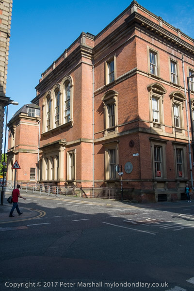
A closer view shows some of the fine detailing on the Grade II listed building built in a Queen Anne style in 1909 as factory, offices and wholesale showroom for manufacturing pharmaceutical chemists Fletcher, Fletcher and Company Ltd. Grace’s Guide lists their specialities: ‘”Vibrona” the Ideal Tonic Wine, of which they are the proprietors; is largely prescribed by the medical profession as a Tonic Restorative. ” Bronamalt,” an Ideal Tonic Food for delicate Children and Invalids. Also proprietors of Fletchers’ Syrups of the Hydrobro mates and Fletchers’ Concentrated Liquors, all of proved value. Are the patentees of Fletchers’ Thermo-Hydrometer and Fletchers’ Autometric Stopper, also of Endolytic Tubes for Clinical Diagnosis.
Other products included Effico tonic, Flexaphyll deodorant tablets, Aperigran laxative granules and Rubelix cough syrup. They called the buildings Vibrona House and remaines there until the 1960s when it was bought by Vortex Jersey Ltd.
The building was only listed in 2007, and the listing text comments: “The building has been little altered and retains several features of note including panelling, a glazed partition, a fireplace and rare historic automatic door, an unusual feature in commercial buildings of the era. The difference between the manufacturing and commercial spaces is clearly marked by two staircases which are both of special interest: the utilitarian stone staircase with metal balusters providing access to the factory and the grand timber Jacobean staircase serving the offices and commercial areas.“

At the next crossroads I turned north up Hornsey Road and photographed the Hornsey Road Baths – Grade II listed in 1994. Another Queen Anne style building, this was built in 1891-2, designed by architect Alfred Hessell Tiltman (1854-1910).
When opened it had two pools for men and one for women, but such was demand that the baths were enlarged in 1894 and a second women’s bath was added in 1900. The listing text concludes by mentioning the “remarkable neon Diving Lady on the South flank elevation, one of 12 such illuminated features placed on swimming pools and lidos in London in the 1930’s and now believed to be the only survivor.”

The frontage of the baths has the text ‘PUBLIC BATHS AND WASH HOUSES’ incised across it. The wash houses or laundry were added in 1894 and had a large drying room; they became self-service in 1965. The baths were refurbished at a cost of £1.5 million in 1985 and as the board shows were still in use for swimming, warm baths and a sauna when I took these pictures. But lack of funds led to the closing of the baths and laundry the following year.
From 2002-9 the baths were redeveloped, retaining the listed entrance block on Hornsey Road and the chimney but providing 200 apartments, some at affordable rent and others for private sale, an office building for Islington Council and a Sure Start Centre for parents and children.
More from my walk in a later post.
Flickr – Facebook – My London Diary – Hull Photos – Lea Valley – Paris
London’s Industrial Heritage – London Photos
All photographs on this page are copyright © Peter Marshall.
Contact me to buy prints or licence to reproduce.