My wandering around Highgate on Sunday 19th November continued. You can read the previous part at Houses, Trees & Walks – Highgate 1989.

I continued along North Road. Fire Station Cottage dates from 1906 and as the name suggests was built as a fire station. According to British History Online, “A room in North Road, Highgate, was hired in 1882 and a portable fire station was opened in 1887” with a fire engine manned by volunteers. This building was built as a replacement. It had closed as a fire station before World War Two but was reopened for use in the Blitz.

Taken from beside The Old Gate House pub at 1 North Road, a 1930s faux antique timber framed building with only its sign in my picture, I was looking across to Highgate School, founded by Roger Cholmeley in 1565, and formally ‘Sir Roger Cholmeley’s School at Highgate’. The current school fees for Years 7-13 are £8,830 per term and with VAT at 20% that comes to almost £32,000 a year. The per-student annual cost of public education in the UK in 2023-4 was £7,600.
The Grade II listed chapel was designed by Frederick Pepys Cockerell and built in 1865-6 and has an unusually long description in the official listing text.

Pond Square is certainly not a square, but a strangely shaped quadrilateral one side of which is South Grove. I rather liked the atmospheric nature of this image taken into the light which nicely illuminates what must surely be a gas lamp, as well as the many fallen sycamore leaves. The building on the right is 6 Pond Square and the church in the distance is St Michael’s Church, Highgate.
As well as not being a square, Pond Square does not have a pond, but rather more usefully does have public conveniences. There had been two man-made ponds here, the first apparently dug out as a hobby by a local hermit in the fourteenth century. Both were filled in by the local council in 1864 as unsanitary.

South Grove forms the southern side of Pond Square and the Highgate Literary & Scientific Institution is at Number 11 on its junction with Swains Lane. It was founded in 1839 to enlighten the local population about the new developments in science and industry that were revolutionising the country. It still continues to do so.
It moved to this Grade II listed building in 1840 and remodelled it both then and later in that century. According to the listing it had previously been in use as a school for Jewish boys, and other sources suggest it may have been built on the cellars “of the Swan, Highgate’s first alehouse dating from the fifteenth century“.

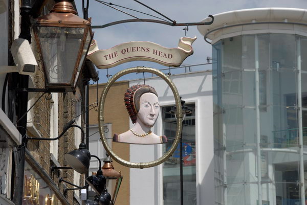
There was a brewery and pub on this site at least by 1610, but it was given a new frontage in 1880 and then completely rebuilt in 1928-30. But though I liked the sign I was more impressed by the Barclays Bank and the adjoining building on the opposite of the street.
Barclays closed the bank at 54 High Street in 2020, selling it for £1.8 million and Highgate no longer has a bank. I think these buildings probably date from the late 1890s.
More from this walk in a later post.
Flickr – Facebook – My London Diary – Hull Photos – Lea Valley – Paris
London’s Industrial Heritage – London Photos
All photographs on this page are copyright © Peter Marshall.
Contact me to buy prints or licence to reproduce.