More from Tollington Park – 1990

More from Tollington Park – 1990 continues my walk which began at Kings Cross on Sunday February 11th 1990 with the post Kings Cross and Pentonville 1990. The previous post was Fonthill & Tollington.

House, Tollington Park, Finsbury Park, Islington, 1990, 90-2c-12

Tollington is a district whose name dates back at lease into Saxon times. According to Eric A Willats’ ‘Streets With A Story‘, from which much of the information in this post comes, “It was spelt ‘Tollandune’ in the Anglo-Saxon Charters meaning the hill or pasture of Tolla. ‘Tolentone’ meant a pannage for hogs, a place of beechwood and mast. This area and Holloway were all then part of the Great Forest of Middlesex. It
had various spellings Tolesdone, Tolyndon, Tallingdon and Tallington
.”

Modern development of the area, then farmland, began early in the 19th century; “About 1818-1820 ‘a pretty range of villa residences were erected in the Italian style by Mr. Duerdin, with stabling and offices attached, from the designs of Messrs. Gough and Roumieu.’” These are now 96, 102, 106 and 110 Tollington Park.

House, Tollington Park, Finsbury Park, Islington, 1990, 90-2c-13

Like many other early and mid-19th century developments the villas were first given their own distinct subsidiary names and only became numbers in ‘Tollington Park’ in 1871, Willats gives the following details:

After 1871 subsidiary names were abolished, e.g., Belmont Terrace became nos2-6, Birnam Villas 8-10,St Marks Villas 16-22, Claremont Villas 24-36, Duerdin Villas 44-56, Fonthill Villas 60-70, Syddall Villas 59, Syddall Terrace 63-73, Regina Villas 89-101, Shimpling Place by 1882 nos15-155 Upper Tollington Park, Harrington Grove 1848/9 became after 1894 47 to 67 and 52 to 70 CHARTERIS ROAD. Nos96 to 108 have been attributed to Gough & Roumieu, built 1839-40

House, 53, Tollington Park, Finsbury Park, Islington, 1990, 90-2c-14

This corner house has been significantly modernised but retains its tall archway and fits in well with the adjoining houses out of picture to the left. It doesn’t get a mention on the fine map of ‘Historic Tollington’ which was “created by the incredibly vibrant Tollington Park Action Group in 1994.” As well as the plan of the streets this contains informative annotation on 26 sites in the area and would have been very useful to me as a guide to the area which I photographed four years before the map was made.

House, 20A, Turle Rd, Finsbury Park, Islington, 1990, 90-2c-15

Willats suggests the road was “Probably named after a John Turle of no.11 Tollington Park who was at that address in 1830 and in 1833.”

George Orwell School, Turle Rd, Finsbury Park, Islington, 1990, 90-2d-65

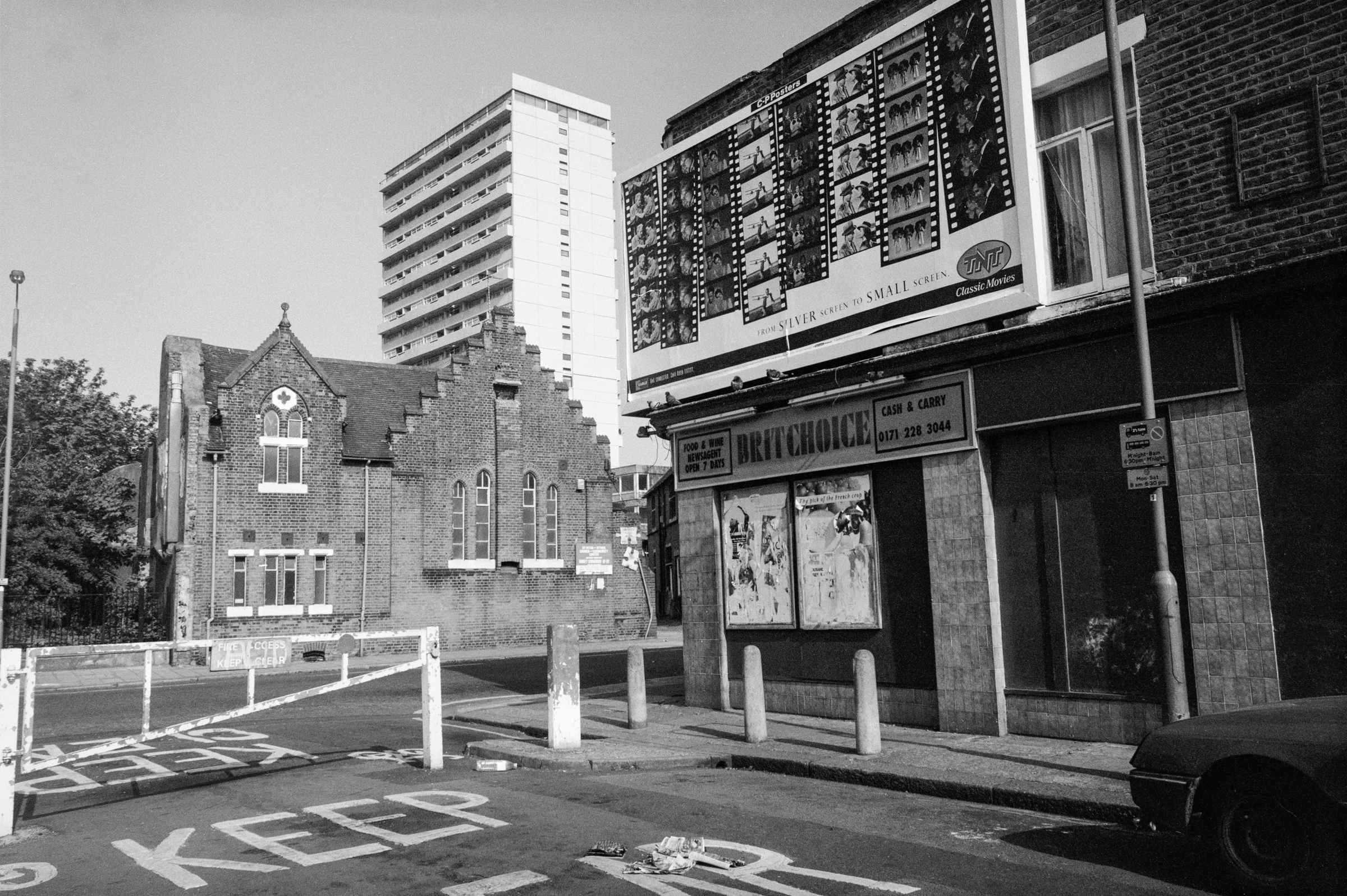
The former Tollington Park School first opened in 1886. It gained some new buildings to add to its Victorian main block in 1930 but these were demolished by bombing in 1940. I think my picture shows the new extension built in 1955.

It was renamed by the Inner London Education Authority in 1981 after Eric Arthur Blair, better known as George Orwell, in 1981. He had lived not far away at 27b Canonbury Square from 1944-7. The name of this ‘secondary modern’ school was changed when it was merged with Archway Secondary School and it disappeared in 1999 following a damning Ofsted inspection of all Islington’s schools, re-emerging as Islington Arts and Media School.

The school’s most famous former pupil is photographer Don McCullen who was born and grew up in Finsbury Park nearby.

St Marks, church, Church Hall, Moray Rd, Finsbury Park, Islington, 1990, 90-2d-53

Work began on building the church in 1853; its architect was Alexander Dick Gough (1804-71) who lived at 4 Tollington Park. He was a pupil of Benjamin Dean Wyatt and for some years worked in partnership with Robert Lewis Roumieu; their work together in North London included the Islington Literary and Scientific Institution (now the Almeida Theatre), the rebuilding of the Norman St Pancras Old Church and several Italianate villas in Tollington Park mentioned above.

After their partnership was dissolved in 1848, Gough designed or redesigned over a dozen churches in North London and elsewhere, many now demolished, along with other buildings. St Mark’s required some structural alterations in 1884 and was renovated in 1904.

Tollington Court, Tollington Place, Finsbury Park, Islington, 1990, 90-2d-54

These 1938 flats are on the corner of Tollington Place and Tollington Park and I was standing a few yards down Moray Road to make this picture, with the square and fluted round pillars of St Mark’s Mansions, 60 Tollington Park, at the left. This building is locally listed as a semi-detached Italianate villa dating from around 1850.

St Marks Mansions, Tollington Park, Finsbury Park, Islington, 1990, 90-2d-55

This shows the neighbouring semi-detached villa of St Mark’s Mansions and the poor decorative state of many of the buildings like this long converted into flats in Tollington Park. The area has been considerably gentrified since 1990 and it is hard to believe the state of the properties then when you look at them now.

See what Tollington looked like in the 60’s & 70’s has a collection of pictures by Leslie William Blake taken before the area had begun to receive any real investment following extensive bomb damage in the war. The article states “it wasn’t until the late Sixties that any real investment began” to come into the area, and my pictures from 1990 show that there was still much to do.

More pictures from my walk in a later post.


FlickrFacebookMy London DiaryHull PhotosLea ValleyParis
London’s Industrial HeritageLondon Photos

All photographs on this page are copyright © Peter Marshall.
Contact me to buy prints or licence to reproduce.


Fonthill & Tollington – 1990

Fonthill & Tollington continues my walk on Sunday February 11th 1990 which began at Kings Cross with the post Kings Cross and Pentonville 1990. The previous post was Caledonian Road, Barnsbury & Lower Holloway – 1990.

Tower House, 149, Fonthill Rd, Finsbury Park, Islington, 1990, 90-2c-32

The Tower House it at the south end of a late Victorian terrace at 141-9 Fonthill Road close to the junction with Seven Sisters Road. This was the factory and showroom for Witton, Witton & Co. In an advertisement in Musical Opinion & Music Trade Review they describe it as ‘BRITAIN’S FINEST FACTORY’ producing ‘”THE IDEAL BRITISH PIANO” Specially made for Variable Climates’. According to the Pianoforte-makers in England web site the company was formed in 1874, although earlier Wittons had made pianos from 1838. They held two patents related to pianos. The name continued in use after production went abroad in the 1930s. Their grand pianos are said to be not well made.

By 1990 the tower had lost its top floor topped by a cupola. Like much of Fonthill Road the building was mainly in use by clothing manufacturers and wholesalers in 1990.

Goodwin St, Finsbury Park, Islington, 1990, 90-2c-35

The 3 storey house in this picture is still present on Goodwin Street, a turning off Fonthill Road which now leads through City North House to Finsbury Park Station. This is 11 Goodwin St, owned by the Trustees of Peace News and the home of CND, the Campaign Against Arms Trade as the hanging sign above the double door indicates, along with various other groups. I think the right hand door was number 13, though the numbering around here seems rather random.

Shops, Fonthill Rd, Finsbury Park, Islington, 1990, 90-2c-36

The rather strangely staggered roofline is still there at 138 Fonthill Road and all the shops are still in the clothing trade, though I think all the names are changed. Photographer Don McCullin grew up in the area in the 1940s and described the area as “a battlefield” and later he was to photograph on many real ones, including in Cyprus.

It was the Cyprus emergency with the UK fighting EOKA in the the late fifties and the later war between Greeks and Turks that led to many Cypriots to come to live in North London – and a number of them set up clothing factories and wholesale businesses here – and others from Turkey, the Caribbean and Africa came too. At first shops here were simply wholesale, but then many began to open on Saturdays for retail sales, and the street was crowded with people – mainly women – buying real bargains.

Fonthill Metal Co, Fonthill Rd, Finsbury Park, Islington, 1990, 90-2c-21

I don’t think any trace remains of the Fonthill Metal Co or the garage next door on Fonthill Road which were almost at the end of Fonthill Road close to Tollington Park. There used to be many similar small scrap metal dealers who would pay cash on the spot for non-ferrous metals – Copper, Brass, Lead, Zinc and Ali – aluminium.

BRAIZERY here means copper pipes and other material which has been soldered and so contains small amounts of other metals, particularly tin and lead. If you have a decent load of this you can probably get around £6 a kilo for it – but no longer on Fonthill Road.

Velvet Touch, Fonthill Rd, Finsbury Park, Islington, 1990, 90-2c-22

Later retail clothes shops elsewhere in the country found they could buy clothing cheaper abroad than garments made in the UK, and manufacturing here started to fall away. Slowly more and more wholesalers welcomed retail customers and many new wholly retail shops opened.

More recently the retail trade has fallen away too as the area becomes increasingly gentrified. Most of the clothes still on sale are now made abroad, particularly in Turkey.

Velvet Touch at 1 Fonthill Road was at the far end to the other clothing manufacturers, wholesalers and importers and although you can still read that line of their shopfront, (rather faded now) their name and the large sign on the side wall are long gone and I think the building is now residential. The very small window on the first floor is still bricked up.

St Mellitus, RC, Church, Tollington Park, Finsbury Park, Islington,, 1990, 90-2c-23

Built as the New Court Chapel in 1871 by Congregationalists from New Court, Carey St, Lincoln’s Inn Field after their chapel had been demolished to build the Royal Courts of Justice.

The Neo-classical church, designed by C G Searle seated 1,340 and in the early years was often full in the early years, but after the war congregations dropped away. It was sold to the Catholic Church in 1959, becoming St Mellitus RC Church. St Mellitus was the first Bishop of London in 604CE and later in 619CE became Archbishop of Canterbury.

House, Tollington Park, Finsbury Park, Islington, 1990, 90-2c-24

Tollington Park was one of the first streets in this northern part of Islington in Finsbury Park (estate agents like to call it Stroud Green, but that seems rather a stretch too far) to be laid out and its grand semi-detached villas date from the 1830’s and 40’s.

Before that cows had grazed its fields to supply milk to London across north Islington which had what was claimed to be the largest dairy farm in the country, run by Welsh dairy farmer Richard Laycock.

By WW2 the area had deteriorated and become a poor working-class area. It was heavily bombed in WW2 and much still remained in a mess twenty years later. By the 1970s it was home to many migrants from across the world, including “Welsh, Irish, Jamaican, and others from all over the world.”

House, Tollington Park, Finsbury Park, Islington, 1990, 90-2c-26

Many of the damaged properties and some others were demolished in 1970 to form a park, Wray Crescent, and gentrification of the area set in. The Friends of Wray Crescent history page contains a number of pictures of Tollington in the 1960s and 1970s, taken by Leslie William Blake when “local campaigners and the Tollington Park Action Group began to fight to preserve some of the buildings, including the creation of the local conservation zone.”

Houses like those in my picture are now all or almost all a number of flats. Only 4 houses in Tollington Park are Grade II listed (along with the two churches) but many are locally listed including these two at 104 and 106, thought to have been built in 1840.

More from this walk to follow.


FlickrFacebookMy London DiaryHull PhotosLea ValleyParis
London’s Industrial HeritageLondon Photos

All photographs on this page are copyright © Peter Marshall.
Contact me to buy prints or licence to reproduce.


Churches, Flats, Houses & a Pineapple – Highgate 1989

Churches, Flats, Houses & a Pineapple: More from my walk in Highgate on Sunday 19th November. You can read the previous part at Almshouses, Museum, Hospital & Shops – Highgate 1989

St Augustine of Canterbury, Church, Archway Rd, Highgate, Haringey, 1989 89-11g-46

This large Anglican church on Archway Road is immediately to the south of the fine parade of shops which ended the previous post. It always looks to me more like a Catholic Church than an Anglican one, probably because of the sculptural decoration on and above its doorway, and my impression seems to be correct.

The church is a product of three leading members of the Art Workers Guild, a body founded in 1994 promoting the ideas of William Morris and the Arts and Crafts movement. It was begun in 1888 by John Dando Sedding (1838 – 1891), one of the Guild’s founders in 1886-7 its second master and the west front shown here was completed in 1916 by his chief assistant Henry Wilson (1864–1934) with the Calvary added then by J Harold Gibbons (1878 – 1957.)

The church describes itself as a “friendly Anglo Catholic parish church” and has recently “due to theological convictions regarding the catholicity and sacramental integrity” of its mission asked to be removed from the care of Dame Sarah Mullally the Bishop of London and has been transferred to the See of Fulham which has a male Bishop.

Houses, Cholmeley Park area, Highgate, Haringey, 1989 89-11g-21

I walked up Archway, and photographed the Winchester Tavern (not on line) at 206 before turning west down Cholmeley Park where I think I took this picture of a 1930s suburban house with a circular window beside the door and a rounded bay with Crittal windows. I think I felt it was a rather typical building rather than anything exceptional, something I tried to include in my project.

Flats, 55, Cholmeley Park, Highgate, Haringey, 1989 89-11g-23

But these flats are clearly unusual, and the facade here was the entrance to the building set up here by the Santa Claus Society in 1890 or 1900 (sources differ) to provide 20 long-term convalescent beds for children with hip and spinal diseases.

The hospital became part of the NHS and was closed in 1954. It was converted by the London County Council in 1954 to provide hostel accommodation for 31 men suffering from tuberculosis who had “reached their maximum degree of improvement under hospital treatment but who cannot be discharged because they are homeless.”

Pineapple, Waterlow Park, Highgate, Camden, 1989 89-11h-65

Waterlow Park on a hillside below Highgate Village is one of London’s finest parks and when in the area I’ve often had a short rest in it, finding a suitable spot to eat my sandwiches.

This fine example of a pineapple is beside some steps in the park and I think is one of those produced by Eleanor Coade, who ran Coade’s Artificial Stone Manufactory, Coade and Sealy, and Coade in Lambeth, London, from 1769 until her death in 1821.This hard-wearing architectural material is virtually weatherproof. Coade Stone was produced by a secret process involving double firing of stoneware which died with her final business partner in 1833. It has been revived in recent years by Coade, a company “born due a lack of skilled craftsman capable of restoring the original Coade stone sculpture.”

Pineapples were a common architectural decoration in Georgian and Victorian times, symbolising wealth and fine taste.

Cloisters Court, Cromwell Avenue, Highgate, Haringey, 1989 89-11h-51

I came out of Waterlow Park and crossed Highgate Hill to Highgate Presbyterian Church on the corner between Cromwell Avenue and Hornsey Lane. Designed by Potts, Sulman & Hennings, a fairly short-lived partnership from 1885 to 1891 between Arthur William Hennings, Edward Potts and Sir John Sulman (who left for Australia in 1885) in a Gothic Revival style was completed in 1887. In 1967 it became Highgate United Reformed Church and was converted into flats as Cloisters Court in 1982.

Flats, Hornsey Lane, Haringey, 1989 89-11h-42

This fine terrace is at 57-71 Hornsey lane and I think dates from around 1900, probably the late 1890s, and is joined at its west end to a slightly grander central block at 39 at extreme left of the picture, (where are 41-55?) with Linden Mansions continuing to the west to the former church on the corner of Hornsey Lane.

My walk continued down Hornsey Lane – more in a later post.


FlickrFacebookMy London DiaryHull PhotosLea ValleyParis
London’s Industrial HeritageLondon Photos

All photographs on this page are copyright © Peter Marshall.
Contact me to buy prints or licence to reproduce.


Shops, a Poly, Electricity, Church & Library – 1989

Shops, a Poly, Electricity, Church & Library: Continuing my walk in Islington on Sunday 15th October 1989 which began with the post Memorials, Eros and More.

Dorset House, 217-9, Holloway Rd, Lower Holloway, Islington, 1989 89-10g-45

I walked back from Hornsey Road to Holloway Road and took this picture of Dorset House on the corner of George’s Road, then the Unique Butchers at 217 and Wai Shang Chinese Take Away at 219. This building had changed little by 2022, though the butchers was then a closed cafe up for sale and the Chinese take-away was now Green Jade.

I’m surprised that this building does not appear to be locally listed, though it is a shame that it has lost the balustrade on its left side. On Drawing The Street where you can see a more recent drawing of the building @ronniecruwys points out that the detailing of the balustrade is identical to that of Southwark Bridge, but that dates from 1921, when Rennie’s earlier bridge was rebuilt. A comment on that post states “My 2 x great grandfather lived here in 1881. His name was Henry Appleby and his father in law who was the head of the house in 1881 (census) was a retired Policeman named Walter Tovey.”

My guess is that this house probably dates from the early 19th century, but like others I have failed to find out more about its history. George’s Road was originally George’s Place, built by George Pocock.

Polytechnic of North London, Holloway Rd, Hornsey Rd, Lower Holloway, Islington, 1989 89-10g-33

Wikipedia tells me the Polytechnic of North London was granted university status to become the University of North London. It existed under that name until 2002, when it merged with London Guildhall University to form London Metropolitan University. It had been formed from Northern Polytechnic, founded in 1896 and North-Western Polytechnic in 1971.

This building mirroring its surroundings is on the corner with Hornsey Road and was rather appropriately I think next to a mirror shop and factory at left of picture, which later in 1994 was redeveloped as the Learning Centre library.

Pyracrest Ltd, 71 Hornsey Rd, Caedmon Rd, Lower Holloway, Islington, 1989 89-10g-22

This shop remained in commercial use until recently, though not for joinery, display and general woodwork but most recently as a glass merchant. It was sold in 2012 and extended. The garage on the opposite corner, shown here only by a Michelin Man poster on the wall closed around 2009 and was replaced by a new residential development with a ground floor café.

Caedmon Road was earlier called Spencer Road, renamed in 1938. Developed in 1866 it was renamed after Caedmon the earliest known English poet, a Northumbrian cowherd working at Whitby Abbey whose only known surviving work is the nine lines of Cædmon’s Hymn. You can read this on Wikipedia and will find only a slight resemblance to modern English – though possibly more to Geordie or the other impenetrable dialects of the north-East.

The Vestry of St Mary Islington, Electric Light Station, Eden Grove,  Lower Holloway, Islington, 1989 89-10g-26
The Vestry of St Mary Islington, Electric Lighting Station, Eden Grove, Lower Holloway, Islington, 1989 89-10g-26

Conveniently the title of this locally listed building at 60 Eden Grove is shown on its exterior along with the date of 1896. As the Islington Society states, Islington was one of the earlier local authorities to distribute electricity. The vestry’s work was taken over by the Metropolitan Borough of Islington in 1900.

At first this power station was only for street lighting, but soon the wealthier inhabitants of the borough could get power for their homes and they say by 1936 it was supplying “40,000 customers through 106 miles of mains.

Former St James, church, Chillingworth Rd, Lower Holloway, Islington, 1989 89-10g-12

This Grade II listed Neoclassical church was built as St James the Apostle Church in Victoria Road (later Chalfont Road, later Chillingworth Road) in 1839, architects Henry William Inwood and E N Clifton. The east end was extended in 1840 by Hambley and he added the tower in 1850. The top section of this was later removed, possibly after bomb damage, in 1944.

The parish was united with St. Mary Magdalen in 1953-4 and a parish hall built in the shell of the church. Converted to offices and recording studio in 1980-82 and renamed St Mark’s Studios. Probably then the concave entrance shown here was constructed and the original pilasters on the facade were replaced by pillars.

Islington Central Library, Fieldway Crescent, Holloway Rd, Lower Holloway, Islington, 1989 89-10g-15
Islington Central Library, Fieldway Crescent, Holloway Rd, Lower Holloway, Islington, 1989

This frontage on Holloway Rd dates from 1906, architect Henry T Hare; the building was enlarged in 1973-6, and has recently undergone considerable refurbishment. It is Grade II listed.

The library was built for the Metropolitan Borough of Islington and received funding of £20,000 from Andrew Carnegie and was opened in October 1907 by Sir Arthur Rucker, principal of the University of London. The bust at the left is of Spenser and that at the right, cruelly cropped, of Bacon. It remains open as a public library.

More to come from this walk later.


FlickrFacebookMy London DiaryHull PhotosLea ValleyParis
London’s Industrial HeritageLondon Photos

All photographs on this page are copyright © Peter Marshall.
Contact me to buy prints or licence to reproduce.


Maryland My Maryland, Stratford 1989

Maryland My Maryland, Stratford 1989: It was not until the beginning of September 1989 that I found time to return to London, starting my walks there again on Sunday 3rd September at Stratford in East London and walking from the station towards Maryland.

Tom Allen Centre, Grove Crescent Rd, Stratford, Newham, 1989 89-8p-21

Nobody is absolutely sure why Stratford has an area called Maryland but it could be that this is an unusually named after Maryland Point on the Potomac River in Virginia. Richard Lee (1617-1664) emigrated to the then colony around 1640, making a fortune as “a tobacco planter, trader, an owner and trader of slaves, and an employer and importer of English indentured servants.” Returning to England in 1658 he bought land in Stratford and owned a large house there. The name Maryland Point is first known to have appeared on a map in 1696.

Trinity College Oxford set up a College Mission “in connexion with the Great Eastern Railway Works at Stratford le Bow” around 1890 and it continued there until destroyed by a German air-raid in 1941.

Tom Allen came to work at their mission in Bermondsey while still studying at Trinity in 1909 where he obtained a “Fourth in History” and a Rugby Blue. From 1911 to 1914 he was Warden of the Stratford mission but when the war broke out enlisted as a private in the Grenadier Guards, but was soon offered a commission in the Irish Guards. The following February he went to France “where less than one month later, in the firing trenches near La Bassée he was killed instantaneously by a shell.” He was only 27. The centre named for him was built in 1957.

It is now The Sanctuary, home to The Redeemed Christian Church of God.

Maryland Works, Grove Crescent Rd, Stratford, Newham, 1989 89-8p-22

I can’t make out the name of the company once engraved on the building of the Maryland Works at 20/22 Grove Crescent Road as it is partly covered by the later sign board for ( I think) ‘MTM ties around the world of B J Bass & Co Ltd.’ It and the offices beyond are long gone, replaced by blocks of flats, backing on to the railway.

The Grove Picture Theatre, The Grove, Maryland, Stratford, Newham, 1989 89-8p-23

Built in 1910 by Frazzi Fireproof Construction Ltd of Whitechapel the Grove Picture Palace later became a billiards hall. Although unused and in a rather poor stage it still retained its original decoration and railings in 1989, though its signage above the ground floor had gone. The sign ‘READ GOD’S WORD THE BIBLE’ was on the wall belonging to the Central Baptist Church next door,

The Grove Picture Theatre, The Grove, Maryland, Stratford, Newham, 1989 89-8p-24

You can see pictures of it as built and as a surgery on Arthur Lloyd’s Theatres in Stratford East page.

The Grove Picture Theatre, The Grove, Maryland, Stratford, Newham, 1989 89-8p-25

Another image of the former cinema. It appears now to have been restored very much to its original state despite not even being locally listed.

Bacchus's Bin, Leytonstone Rd, Maryland, Stratford, Newham, 1989 89-8p-11
Bacchus’s Bin, Leytonstone Rd, Maryland, Stratford, Newham, 1989 89-8p-11

Leytonstone Road starts at the north end of The Grove after it crosses the railway and runs parallel to the tracks to Maryland Station before turning north.

These buildings at 7-13 Leytonstone Road are still there but a little altered with the roof of Bacchus’s Bin (now BAR ONE and Thailander Restaurant) having had its gables and the half barrels and sign at first floor level removed. The Chevy Chase pub at No 11 closed in 2010, was until 2014 a restaurant and after being empty for a couple of years is now a solicitors.

Church, Francis St, Maryland, Stratford, Newham, 1989 89-8p-12

This is Emmanuel Hall and is now the Without Borders Church. It has lost its large cross and most of the row of windows along its side since I made this picture.

Maryland Video, Maryland, Stratford, Newham, 1989 89-8p-15

This picture on the corner looking north where Leytonstone Road turns north with the tower block of Henniker Point in the distance was the first image in the body of my Blurb book, ‘1989’, ISBN: 978-1-909363-01-4, published in 2012 and still available both as softcover or PDF. I had previoiusly published the work on the web in 2006 and it was exhibited in the 2010 London International Documentary Festival – I think the first occasion on which this festival featured still photography.

This is one of only two books of mine which are image/text pieces, though others have some separate texts. For the text I misappropriated the name ‘Upton Sinclair’, an American write and political activist who died in 1968, but I was thinking of nearby Upton Park and the well-known psychogeographic writer Iain Sinclair whose works on London I had long admired. After all there are hundreds if not thousands of us ‘Peter Marshalls’ so why not one more Upton Sinclair?

The blurb on Blurb about ‘1989’ states: ” ‘1989′ claims to be Chapter 1 of a book based on the notes made by the photographer on a walk through the streets of north-east London with a well-known author of ‘psycho-geographical’ works.

But the author is entirely fictional, and the notes, written in 2005, after his death and sixteen years after the pictures were taken are in part a gentle spoof on psycho-geography but more importantly a reflection on photography and the documentary process.”

Parts of it I still find quite funny and it really is one of my favourites among my books.

More from this walk on a later post.


FlickrFacebookMy London DiaryHull PhotosLea ValleyParis
London’s Industrial HeritageLondon Photos

All photographs on this page are copyright © Peter Marshall.
Contact me to buy prints or licence to reproduce.


Charterhouse, A Diary, School, Church & Houses

Charterhouse, A Diary, School, Church & Houses continues my walk on Friday 4th August 1989 in Battersea from the previous post, St Peter & St Paul, Candles, A Pub & Distillery. My walk began with Council flats, Piles of Bricks, A House Hospital and Brasserie.

Charterhouse Works, Eltringham St, Battersea, Wandsworth, 1989 89-8c-65

I turned south from York Road into Petergate and turned int Eltringham Street where I think I took this picture of the Charterhouse Works. It’s hard to read the peeling paint of the notice on the side, but I think these were once the works of Sandle Brothers, Manufacturing Stationers, Wholesale & Export with City Offices & Showroom at 4 Snow Hill EC4. You can see more about them on Spitalfields Life.

There appears to be a very long list of current occupants on the front of the building and on the full size image I can make out some of the names of what appear to be small businesses with workshops or offices in the building.

I think this is now the site of Charterhouse Appartments at 21 Eltringham St, a large modern block.

Nicholson & Co, 115, 119, Plough Rd, Battersea, Wandsworth, 1989 89-8c-52

I made my way through the back streets to Plough Road, probably going along the footpath beside the railway line, Tours Passage. On the way I passed a heap of black sacks of rubbish with horse that had come from a fair roundabout, which I photographed but have not yet digitised.

Going under a railway bridge and walking down the road took me opposite the works of Nicholson & Co Ltd at 115-7 Plough Road, Heating – Ventilating – Air Conditioning Engineers established in 1904. Next door at 119 is a rather more ornate building with the date 1902 in its gable. The 2013 Survey of London tells me this was a former diary “designed by William Clinch Poole for the Dairy Supply Company Ltd.”

Plough Road School, Plough Terrace, Battersea, Wandsworth, 1989 89-8c-53

Plough Road School is Grade II listed as Highview Primary School and was built in 1889-90 (the date 1890 appears on it though not in my picture) designed for the London School Board by its architect T J Bailey who was proud of his work and exbibted the designs at the Royal Academy in 1891.

My view is of the back of the building, probably because much of the rest was covered by scaffolding when I made it, but perhaps becuase I thought the architectural influence was more evident. At the right of my picture is a little of the schoolkeeper’s house built at the same time.

St Pauls, Church, Community Centre, Vardens Rd, St John's Hill, Wandsworth, 1989 89-8c-54
St Pauls, Church, Community Centre, Vardens Rd, St John’s Hill, Wandsworth, 1989 89-8c-54

At the bottom of Plough Road I turned right into St John’s Hill and took this picture of St Paul’s Church from the corner of Vardens Road, I think to contrast the slender spire with the pillars of the corner doorway of 129 St John’s Hill. This block, shops with flats above has a rather more delicate entrance to the flats, Harvard Mansions, on Vardens Road. Those pillars seemed unusual in that they clearly were not supporting anything – with a top looking like a chimney. The block was built in the late 1890s in an Arts and Crafts style.

Although this is on St John’s Hill it was built in 1868 as St Paul’s church, as a part of the parish of St John’s Battersea which was on Usk Road. It was needed to accommodate the growing number of worshippers in the area which was beginning to expand rapidly. Later numbers fell and St John’s closed in 1950. This church became part of the parish of St. Peter & St Paul Battersea. Chad Varah who founded the Samaritans was its vicar from 1949-53.

Designed by H E Coe this Victorian Gothic church was build in a Decorated style using Kentish ragstone. Despite some on-line statements it appears to be only locally listed. When I made this picture it was in use as a community centre for the local residents association and as a nursery and it seems only to have been formally de-consecrated in 2013 to allow parts to be converted to flats.

Houses, 13-17, Spencer Rd, Wandsworth, 1989 89-8c-55

I walked west to the next turning on St John’s Hill and went down Spencer Road where a short distance down I found these splendid Victorian villas. Much of the housing in the road is interesting but I was particularly interested in these for their combination of Victorian Gothic and Dutch gables.

Spencer Road presumably gets its name from the various Spencers who were Lords of the Manor in this area. The street was laid out before 1871 but was developed piecemeal and these houses are I think probably a little later.

This walk will conclude in a later post.


FlickrFacebookMy London DiaryHull PhotosLea ValleyParis
London’s Industrial HeritageLondon Photos

All photographs on this page are copyright © Peter Marshall.
Contact me to buy prints or licence to reproduce.


St Peter & St Paul, Candles, A Pub & Distillery

St Peter & St Paul, Candles, A Pub & Distillery continues my walk on Friday 4th August 1989 in Battersea from the previous post, River Thames, St Mary’s, Church Rd, Chelsea Harbour & A Bridge. The walk began with Council flats, Piles of Bricks, A House Hospital and Brasserie.

St Peter & St Paul, Church, l21, Plough Road, Battersea, Wandsworth, 1989 89-8c-74
St Peter & St Paul, Church, 121, Plough Road, Battersea, Wandsworth, 1989 89-8c-74

I left the riverside and walked down Lombard Road and crossed York Road into York Gardens probably to find a pleasant spot to rest a while and eat my sandwiches before going through the gardens to exit on Plough Road close to the church.

St Peter’s Church is still very much alive now on Plough Road, but SPB looks very different to my picture in 1989. The first St Peter’s Battersea was built in 1875 but was seriously damaged by fire in 1970 and the church moved into the building in my picture which had been its church and school hall.

According to ‘Clapham Junction Insider’ Cyril Ritchert, the demolition of this Grade II listed building, “an accomplished example of the free gothic style“, was opposed by the Ancient Monuments Society, English Heritage, the Battersea Society and the Wandsworth Society but was approved by Wandsworth Council in 2010. The developers made a second application in 2015 before any building on the site had started. Google Street View shows the church still in use in 2012.

To finance the new church the developers had been granted permission for an 8 storey block of flats also on the site. Local residents were angered that the developers managed to game the planning system to eventually build a 10 storey block of housing with minimal affordable housing on the site.

Shop, St Peter & St Paul, Church, Flats, Holgate Ave, Plough Rd, Battersea, Wandsworth, 1989

The view of the church from Holgate Avenue shows clearly the position of the church on the edge of the Winstanley Estate to the north of Clapham Junction station. The view of the tower block Sporle Court is now blocked by the new 10 storey block on the church site. The trees at left are in York Gardens.

There is still a billboard and a shop on the corner of Holgate Avenue, but what was then BRITCHOICE is now SUNRISER EXPRESS POLSKI SKLEP. Holgate Avenue was until 1931 known as Brittania Place or Brittania Street and took its name from the Brittania beer house which was possibly in this shop, part of a group of two buildings at 38-40 Plough Lane which are the only remnants of the original 1860s development of the area.

Apparently the Revd Chad Varah, the founder of The Samaritans, was vicar at Saint Peter’s during the 1950’s. St Peter’s was amalgamated with St Paul’s at some time after 1969 – and St Paul’s had been amalgamated with St John in Usk Road in 1938.

Houses, Holgate Avenue, Battersea, Wandsworth, 1989 89-8c-75

According to the Survey of London, “Holgate Avenue, started in the 1920s, was Battersea’s first
successful slum-clearance scheme
.” Poorly built Victorian houses from the 1860s were replaced by these three-storey tenements built by Battersea’s Labour Council in 1924-37 to high standards with some impressive brickwork and detailing. Probably more importantly for the residents they were provided with electric cooking, heating and lighting facilities, unusual luxury for the time.

There was little land in Battersea for building and while the council would have liked to build single family homes it had to compromise with these. But at least tenants at most had only to walk up three flights of stairs, while most new council building by the LCC in the interwar period was in five-storey tenement walk-up blocks.

Price's Candles, York Rd, Battersea, Wandsworth, 1989 89-8c-62
Price’s Candles, York Rd, Battersea, Wandsworth, 1989 89-8c-62

I walked back up Plough Road to York Road, and continued my walk towards Wandsworth Bridge. There was no access to the River Thames on this stretch before the bridge, as the area was still occupied by industrial premises.

Price’s Candles on York Rd was built on part of the site of York House, the London residence of the Archbishop of York from which York Road got its name. You can read more than you will ever want to know about York House in All about Battersea, by Henry S Simmonds published in 1882 and now on Project Gutenberg, which also has a long section on the Belmont Works or Price’s Patent Candle Factory.

Price’s Candles was begun in 1830 by William Wilson and Benjamin Lancaster who had purchased a patent for the separation of coconut fats. They chose the name Price for the business to remain anonymous as candle-making was not at the time a respectable occupation.

They moved to this site in 1847 setting up a large factory and workforce, making candles, soap and other products with stearine wax for the candles and the by products of glycerine and light oils coming cocunuts grown on a plantation they bought in Ceylon. In 1854 they began to import large quantities of crude petroleum from Burma and developed paraffin wax candles. Later they developed processes to work with other industrial wastes, animal fats and fish oils. By 1900 they were the largest candle manufacturer in the world.

The company was taken over by Unilever in 1919, and became owned by other oil companies including BP, who sold part of the site which opened in 1959 as the Battersea Heliport. A few of Price’s buildings remain, though most with added floors, and the rest of the site is mostly new blocks of flats.

York Tavern, pub, 347, York Rd, Battersea, Wandsworth, 1989 89-8c-63

The York Tavern was on the corner of York Road and Usk Road in the late 1850s but was given a makeover later in the century in the typical 1890s Queen Anne style with fake gable facades. I can’t find a date for the closing of this pub but it was clearly very shut when I made this picture. The building was demolished in 2003.

John Watney & Co Ltd, Wandsworth Distillery, York Rd, Battersea, Wandsworth, 1989 89-8c-64

Wandsworth Distillery on York Rd was founded by Richard Bush at Gargoyle Wharf around 1780. By 1874 it was owned by John and Daniel Watney. Gin was produced here, having become popular after heavy taxes were imposed on French brandy, and later particularly in the colonies to counteract the unpleasantly bitter taste of the anti-malarial quinine.

Acquired by Guinness, the distillery was demolished in 1992, and I photographed its occupation as the ‘Pure Genius Eco Village‘ by The Land is Ours in 1996. It was redeveloped as Battersea Reach housing from 2002 on.

More from this walk in another post.


FlickrFacebookMy London DiaryHull PhotosLea ValleyParis
London’s Industrial HeritageLondon Photos

All photographs on this page are copyright © Peter Marshall.
Contact me to buy prints or licence to reproduce.


Light & Life, Pinter and Stockwell Breweries

Light & Life, Pinter and Stockwell Breweries: A week after my previous walk I returned to South London to take more pictures on Sunday 4th June 1989. I began my walk from Clapham High Street.

Landor Rd, Clapham, Lambeth, 1989 89-6b-61

Landor Road, originally named ‘Stockwell Private Road’ but changed at some date before 1912, possibly after the well-known English writer Walter Savage Landor (1775-1864) runs from close to Clapham North Station to Stockwell Green. I made my first picture roughly halfway between the two at the corner with Hubert Grove. A group of five men standing around a car on the opposite side of the road had probably attracted my attention but I clearly did not want to attract theirs.

Many of the shops here have since been converted to residential use.

Light & Life Full Gospel Fellowship, 105-11 Landor Rd, Stockwell, Lambeth, 1989 89-6b-62

A row of four terrace houses here had been converted into the General HQ of the Light & Life Full Gospel Fellowship, and notices gave a full list of activities including Sunday Schools, Divine Worship, Gospel Meeting, Bible Study and Prayer but also Sewing, Cooking, Baking, Musical Rehearsals, Table Tennis , Darts and Snooker. The centre also housed a play group on Monday to Fridays and a Youth Club on Thursday evenings.

A message says ‘COME AND ENJOY YOURSELF – THIS IS NOT A BLACK CHURCH. WE DO NOT PREACH A BLACK GOSPEL – JESUS IS LORD’.

The Fellowship is still continuing its mission there, though with new noticeboards, blinds replacing curtains and a new coat of paint.

Kimberley Rd, Landor Rd, Stockwell, Lambeth, 1989 89-6b-63

I can’t read the notices in the shop window of 127 Landor Road, but I think they might have indicated that the shop had closed. It was perhaps about to be converted to its current residential use.

Looking down Kimberley Road there are two tall blocks of flats, but from my camera position only one is visible, I think Pinter House on Rhodesia Road, one of three blocks in the Grantham Road Estate. 1890s terraced houses there were destroyed by wartime bombing and the site was used for prefabs. Planning for these towers began in the early 1960s under the Metropolitan Borough of Lambeth, but by the time they were completed in 1968-9 they were a part of the London Borough of Lambeth Council.

The three blocks were all named after modern play writers – in this case Harold Pinter. The block was designed by the deputy borough architect George Finch and system built; this 62m high block contains around 92 flats and maisonettes. The flats were refurbished in 2000-2001 after they became managed by Hyde Southbank Homes and now look rather different.

St Andrew's, Church, CofE, Landor Rd, Stockwell, Lambeth, 1989 89-6b-64
St Andrew’s, Church, CofE, Landor Rd, Stockwell, Lambeth, 1989 89-6b-64

St Andrew’s Stockwell Green in Landor Rd was built as a chapel in 1767 but there were later additions and the exterior was rebuilt by H E Roe in this Romanesque style in 1867. Vestries and the Lady Chapel were then added in the 1890s.

The building beyond the church was a large post-war bottle store which was replaced in 2010 by the perhaps deliberately rather bland Oak Square development. This had been a brewery site since 1730 and had been taken over as Hammertons Stockwell Brewery in 1868. It was sold to Watneys in 1951 and they used it as bottling stores.

Two Boys, Landor Rd, Stockwell, Lambeth, 1989 89-6b-65

I find it hard to positively identify this street corner though I think it must be than of Dalyell Road, where Landor Road meets Stockwell Green. The building at left is the now-demolished bottle store, and on it you can read the name THE QUADRANT. The corner is occupied by a giant billboard, and shop appears to have fruit in its window, a sack of potting compost on the ground outside and to sell ice cream.

House, 21, Combermere Rd, Stockwell, Lambeth, 1989 89-6b-66

This is a rather unusual detached house on Combermere Road and I think from my picture that it may have been built or later used as a shop. This is a very mixed street and there was nothing like this anywhere along its length.

It is still there, though the windows have been replaced with something looking rather sturdier and the door has a wrought iron grille.

Stockwell Depot, Combermere Rd, Stockwell, Lambeth, 1989 89-6b-56

Rhodes’ Brewery – Stockwell’s other brewery – took water from an artesian well on this site and was bought by Edward Waltham in 1851. His British Brewery or Half Guinea Ale Brewery in Stockwell Green produced Half Guinea Ale and London Brown Stout at 2/6d per dozen bottles; you paid an extra 6d for the mysteriously named ‘S N’ Stout. It many have stood for ‘Nourishing Stout’, something they also sold as Butler Brand Nourishing Stout.

Back in the 1940s or 50s, my mother, then languishing in hospital, was prescribed a daily bottle of Guinness. As a lifelong total abstainer she refused to drink the demon alcohol, but her Irish nurse had no such qualms.

The buildings probably dated from before 1851. The Lion Brewery bought the company in 1906 and for many years this site was a council depot. It has now been replaced by housing.

To be continued…


Cold Harbour & Myatt’s Fields

My walk on Sunday 9th April 1989 continues in this post, Cold Harbour & Myatt’s Fields. The previous post was Camberwell & Myatt’s Fields.

Church, Shop, Coldharbour Lane, Camberwell, Lambeth, 1989 89-4j-61

Back in 1989 I was still pretty pressed for cash, still buying film in bulk 100 ft lengths and loading it into cassettes myself in total darkness.

Over the years I’d perfected my method. Two nails on the back of my darkroom door, hang one of the sprocket holes at the end of the roll of film on the top one, unroll it down to the second, cut across, replace film in can. Pick up first spool from a waiting row on the bench, already with a short length of masking tape on it, attach to the bottom end of the hanging length of film, carefully roll it up to the top, remove from nail, pick up cassette body, insert spool with film end though velvet light trap, pick up end cap and pinch cassette to push it into place. Repeat another 18 times until the film roll is finished. Turn on light, trim film ends to fit cameras and put into plastic pots to go into camera bag.

Slow, tedious but then less than half the cost of buying film in 26 exposure cassettes, though I did ocasoinally treat myself – and if I bought Ilford film rather than Kodak I could reuse the cassettes with bulk film. Kodak had crimped on ends which had to be removed with a bottle cap remover destroying them.

I had learnt to be very careful with film in this project to photograph London, working with 35mm cameras much as I would have done with large format camera, carefully considering various viewpoints before deciding on an exposure. But when working with people I had to respond rather more quickly, and seeing these two men in front of the white church door my response was immediate.

Shops, Coldharbour Lane, Camberwell, Lambeth, 1989 89-4j-62

After that rather snatched image I continued with photographing the two shops which had attracted my interest here, making first a vertical image and then moving back across the road for a wider view. In this (below) you can see the notice for the Celestial Church of Christ and the alley leading to this.

Shops, Coldharbour Lane, Camberwell, Lambeth, 1989 89-4j-63

As well as these black and white images I also took a couple in colour which you can see in another album. I had two Olympus OM bodies with me and only brought the one with colour negative film out of my bag occasionally, while the black and white camera was usually on a strap around my neck. When I was intending to photograph people rather than buildings I usually went out with a Leica M2 instead.

Coldharbour Lane leads from Camberwell to Brixton and got a very bad reputation after the 1981 clashes between police and locals in Brixton. In 2003 it was called in an article in the London Evening Standard the most dangerous street in the most dangerous borough in London, but that was lagely rabid tabloid journalism. Wikipedia gives several theories about its name none of which seem entirely convincing, but the name seems often to have been associated with the ruins of Roman or Romano-British settlements, The area we know usually call Loughborough Junction around the station on early maps was called Cold Harbour. Coldharbour Lane was then known as Camberwell Lane.

Cafe,  Hinton Rd, Camberwell, Lambeth, 1989 89-4j-65
Café, Hinton Rd, Camberwell, Lambeth, 1989 89-4j-65

The S&J Corner Café was on the corner with Wellfit Street, close to Loughborough Junction station. The railway line here is just south of the station. A second bridge can be seen going above this and the cafe which is the line from Brixton to Denmark Hill, now used by London Overground services.

Cyclist, HInton Rd, Camberwell, Lambeth, 1989 89-4j-51
Cyclist, Hinton Rd, Camberwell, Lambeth, 1989 89-4j-51

Another picture I took on the spur of the moment as I saw a cyclist coming towards me under the bridges on Hinton Road. I was standing on the pavement beside the cafe in the previous image, and the cyclist is on the pavement, rather safer than roads like this in London. At the end of the row of shops on the left are the traffic lights and Coldharbour Lane whch I had just begun to walk towards.

Hinton Rd, Camberwell, Lambeth, 1989 89-4j-52

The pub at right of this picture is The Green Man on the corner with Coldharbour Lane. According to a post on the Brixton Buzz, this had been on the site since 1881, but that is the date of the current building which replaced an earlier pub on the site important enough to be marked on Stanford’s 1862 map. The Buzz says it was closed in 2003 because of drug dealing and crime, and it quotes from the Urban75 blog that it was “was frequented by dealers (crack, heroin you name it), prosi’s and general madhatters.

The buildings at the left date from around the same time as the area was developed around the railways, and number 6 at left has a barely legible road name ‘Hinton Terrace‘ and I think at the top the illegible name of a builder and decorator whose sign presumably once hung on the bracket beside the street name.

House, Lilford Rd, Camberwell, Lambeth, 1989 89-4j-53
Houses, Lilford Rd, Camberwell, Lambeth, 1989 89-4j-53

I walked up past Loughborough Junction and made my next picture on Lilford Road at the corner of Minet Road, returning to the area I had been earlier on this walk, the Minet Estate around Myatt’s Fields. This is on the corner of a terrace with basement flats with an entrance here under the steps which extends along both streets and this grand entrance is actually for two adjoining houses above the flats, one on each street. The Grade II listing calls these “Early-mid C19″ and describes this a “double prostyle composite porch with fluted composite columns.”

Longfield Hall, Knatchbull Rd, Myatts Fields, Camberwell, Lambeth, 1989 89-4j-54
Longfield Hall, Knatchbull Rd, Camberwell, Lambeth, 1989

William Minet founded this Grade II listed community hall, architect George Hubbard, which opened in 1889, as well as the Minet library opposite which was destroyed by bombing and rebuilt in 1956 in what Pevsner described as ‘a meek replacement’. The Library was a memorial for his late wife. The Hall is still in use for various community activities including three church congregations and from 1969 -1975 was the base of Britain’s first Black Theatre Company, ‘Dark And Light’, recently marked by a Blue Plaque. It was Grade II listed in 1979 and is now run by a charity, The Longfield Hall Trust.

My walk made on on Sunday 9th April 1989 will finish in a later post. The first part from it is at Peckham and East Dulwich 1989.


No Third Runway at Heathrow – 2016

No Third Runway at Heathrow

No Third Runway at Heathrow: Heathrow Airport celebrated its 70th anniversary on Monday 30th May 2016. and local residents marked the occasion with a protest on the village green at Harmondsworth against the plans to build a third runway which would destroy over 750 local homes.

No Third Runway at Heathrow

I grew up under the flightpath a couple of miles from touchdown on the main runway used for incoming flights, standing in my back garden and crossing off the registration letters of the planes passing rather close overhead in my spotters book. Those early planes – like the Douglas DC3 and the Vickers Viscount – were small and relatively quiet and gave young boys like me hours of interest with little disruption of normal life, but the generations that followed were very different, larger and ear-shattering. The complaints against their noise grew rapidly – and those easy to read letters on the underside of the wings disappeared so it was harder to identify flights in our complaints.

No Third Runway at Heathrow

Heathrow had been planted on the edge of London’s built up area by deception, beginning as a ‘military’ airport towards the end of the Second World War when it was known it would never be used as such, by people who were determined to make it London’s major civil airport. They did it to get around the objecteons there would have been later to a civil airport here.

No Third Runway at Heathrow
A huge mis-cake’ Heathrow Airport: Celebrating 70 years of unrelenting Aircraft Noise for local communities’

Over the years Heathrow continued to grow and grow. More flights and more terminals. More local traffic and more pollution. Every new development was made with promises that were later broken. T4 was promised to be the last new terminal – but then came the application to build T5. With this came the promise that Heathrow would never ask for another runway – but this was broken even before T5 had opened.

The enquiry into the third runway was said to be final – but while the local community were still celebrating their victory – and David Cameron was saying ” No Ifs, No Buts, No Third Runway”, Heathrow Airport was already plotting the setting up of a new inquiry that would somehow against all the evidence come up with the result they wanted – the Davies Commission.

John Stewart – HACAN – Heathrow want taxpayers to pay for the new roads, tunnels etc needed

In 2016 the threat of the new ‘third runway’ loomed dangerously over the area again, with the Conservative Government backing the proposals. Many of those who came to the event at Harmondsworth feared they would soon lose their homes – and property in the area was blighted as it had been for many years. Others outside the actual development would find their lives made impossible by aircraft noise, with people from almost the whole of West London suffering, particularly from flights in the early morning, with plane after plane passing overhead.

The Heathrow Adobe Hat, with portable air purifier and environmentally biodiverse suitcase

Heathrow’s noise and pollution affect a surprisingly large area of London. Twenty years ago I was in a hospital bed in Tooting in south London, around 12 miles away as the jet flies, awake early in the morning partly by their noise, watching and hearing a whole line of plane after plane in line for touchdown.

Neil Keveren, Chair of Stop Heathrow Expansion (SHE)

In our local area we get the pollution from the planes, both from running their engines on the ground and also from takeoff and landing. But more importantly the airport generates huge amounts of road traffic, both on local roads and the motorways serving the area – M3, M4 and M25.

Seven years on it seems increasingly unlikely that there will ever be a third runway built. Even the most jet-headed politicians are beginning to see that we cannot continue with airport expansion and meet the need to cut carbon emissions. Financial constraints increasingly make it less likely too.

My post on My London Diary has the details about the event on Monday 30th May 2016 and of course more pictures, including some of the village itself, including its pubs, church and remarkable Grade I listed tithe barn, said to be the largest wooden structure in the country, dating from 1426. Local campaigners saved that a few years ago and it was bought by English Heritage in 2012 and has been much restored. It lies just outside the area the airport would take over for the new runway and would be at serous danger from vibration – and would almost certainly need to be re-sited.

A church window remembers Ann & Bryan Sobey who led the ‘Right to Sleep’ campaign for restrictions on night flights into Heathrow

Though on the edge of London Harmondsworth still has a village atmosphere, and still seems much like the village I cycled through in my youth. I hope it remains that way.

More at No 3rd Runway Heathrow 70th Birthday.