East Finchley & Mill Hill: Pictures I took in May 1994 on walks around these areas of North London. I made relatively few colour pictures but you can find many more black and white images in my Flickr album 1994 London Photos.
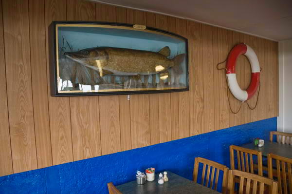
Café, East Finchley, 1994, 94-54-53
I was amused by the contrast between the large image on the wall and the view out of the window. Then the ashtray on every table was the norm. There is a second picture on Flickr with a foreground table and ashtray
Mural, Mill Hill, Barnet, 1994, 94-54-41
The mural on the shed in what I think was a school reflects the multi-ethnic nature of much of London, but not really of Mill Hill. According to the 1991 census only 18% of the population of the London Borough of Barnet belonged to non-white ethnic groups, with 12% Asian and only 6% black; and 2021, 57.7% of Barnet’s population still identified as White. The borough does have a large Chinese origin population and is home to London’s largest Jewish community.
Shop Window, Travel Agent, Mill Hill, Barnet, 1994, 94-54-43
What attracted me to this window was undoubtedly the three very different women it portrays (though the SALLY in large print was only a ferry firm operating out of Ramsgate.)
Perhaps deliberately, though I doubt it, the closest image of a woman is out of focus. I find her rather disturbing , partly because of her blue tint (cyan fades much slower than yellow or magenta inks) but also because of the rigid symmetry of her face and the ridiculous thing at the neck of her top.
Mag-it, Fishing Bait Machine, Mill Hill, Barnet, 1994, 94-54-45
Not only a machine selling maggots, but one which offers you a choice of Red, White and Bronze maggots, mixed maggots, giant maggots, red worms and casters. All apparently frozen and needing to be left in a normal bait box for 60 minutes to recover.
I don’t think there is anywhere in Mill Hill where it is worth fishing.
University of London Observatory, Watford Way, Mill Hill, Barnet, 1994, 94-54-46
Since 2015 this had been called the UCL Observatory as although built for the whole of London University UCL have managed it since 1951, using it as a hands-on teaching observatory. On their web site it states:
“The Observatory building was designed by Mr L. Rome Guthrie and constructed by Messrs Leslie and Co.; construction commenced in July 1928 and was completed in 1929. The Observatory was opened by the then Astronomer Royal, Sir Frank Dyson, on 1929 October 8.”
I’d often looked out of a train window going north from King’s Cross and been surprised as we flashed past this building in an Intercity 125, and wasn’t quite convinced it was real amd not a folly or some figment of my imagination. Who I thought would build an observatory here given London’s weather?
Bunns Lane Car Cleaning Services, Bunns Lane, Mill Hill, Barnet, 1994, 94-54-35
Rather to my surprise you can still get your car washed and valeted on Bunns Lane, though I suspect its days are numbered, along with the adjoining Mill Hill Industrial Estate. The bridge carries the M1 over Bunns Lane and beyond that is a bridge for the main East Coast rail line.
Yorkshire Interlude – Hornsea: On Saturday 12th July 2008 when we were staying for a few days in Hull with an old friend we took a bus to the Yorkshire coast at Hornsea for the day.
I’d first visited Hornsea, a small coastal resort, back in 1965 when I made my first visit to the Hull home of my future parents-in-law, but my wife’s memories of it go back further.
Until Beeching swung his axe there were trains from Hull to two seaside towns, Hornsea and Withernsea which stopped at her local station, Botanic Gardens, a quarter of an hour’s walk from her home. People would often go to them for an outing, for a day or even an evening, and many who lived in these towns would commute to work in Hull.
My wife’s family took their annual holiday most years with a week in Hornsea, staying in a cottage that one of her great-aunts had bought for £25 after it had been condemned for demolition in the near future. I think it was more than 25 years later that it actually came down – and the site is now just a small garden on the main street, a few minutes walk from the seafront.
Most times when we go to Hull now – not as often as we used to as most of those we knew there are now dead or have moved away – we take a bus to Hornsea. What used to be around 40 minutes on the train now takes around twice as long on the buses, though at least it is now free for those of us with bus passes. And the old railway line is now part of a long-distance footpath. Perhaps we will visit again this summer.
We’ve also stayed there, in a holiday cottage in the town centre and a couple of times for a few days at a hotel on the seafront there, where we’ve enjoyed some remarkable sunrises over the wide expanse of the North Sea – as well as some battering storms.
But in 2008 we were staying in one of the finest houses in Hull, West Garth, (more here) then owned by an old friend – an ‘Arts & Crafts’ house which gets a short mention in the guide to Hull’s architecture. It had been one of our friend’s childhood homes and after some years of retirement he bought the property. Various ‘improvements’ had been made which meant it had been denied listing and he spent considerable time and money in restoring it to its original state but sadly died before he completed the job.
The weather wasn’t too good, with some heavy showers, but this did mean that we had the town almost to ourselves, as most of those who would normally have come for a day out at the seaside in July stayed home.
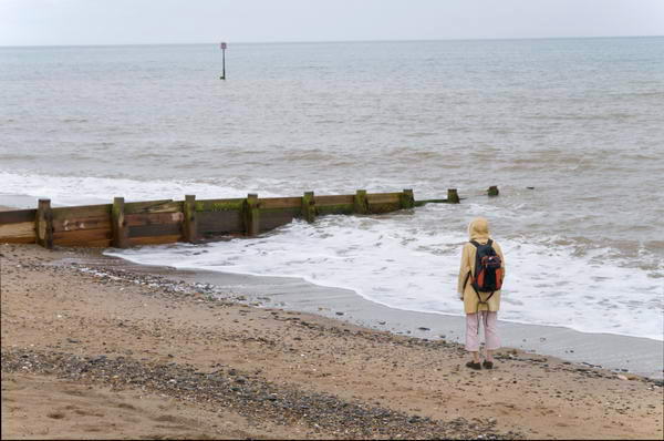
We visited Hornsea Mere, a large freshwater lake at the centre of the town, and a shower gave us a good reason to go into its café before we walked down to the seafront. The sea looked cold and uninviting and for once Linda didn’t paddle.
Then along to another café at the Floral Hall where the sun came out briefly after we had taken shelter there and on the the large park, Hall Garth before it was time to get the bus back into Hull.
This time we took the slower route back via Beverley, getting off in Hull on Beverley Road where I took a picture of Bethnal Green, here just a short terrace of houses, before returning to our friends house to cook dinner.
Despite the weather we had enjoyed a good day.
But it wasn’t a good day to have afternoon tea on the south-facing loggia. You can see many more pictures and some captions from our day at Hornsea on My London Diary.
New River Company, Reservoir, Engine House, Hornsey Lane, Haringey, 1989 89-11h-43
Beyond these large red-brick buildings that line the north side of Hornsey Lane is the grass covered reservoir built by the New River Company and just beyond that across Tile Kiln Lane is their Engine House dating from around 1859. Now called the Pump House the site includes the base of a large chimney for a steam-driven pump. This reservoir and pump and others in the area became necessary as higher areas in Hampstead and Highgate were developed. The locally listed building has more recently been converted to residential use.
Northwood Hall, Flats, Hornsey Lane, 89-11h-35
A few yards further east I crossed the Archway Bridge, where perhaps surprisingly I didn’t take any pictures of the view down the road. I did take three photographs of one of the ornamental lamposts but haven’t digitised any of these. The two at the east end seem rather similar to some of those on the Thames embankment with entwined fish swimming around them. About 5 years ago the fairly low ornamental fence on each side of the bridge has been augmented with a tall metal fence to prevent people jumping to their death on the road below.
Further east of the bridge is Northwood Hall, an art deco block built as “ultra modern labour-saving” luxury flats in 1935 and designed in a cross shape by George Edward Bright who had earlier worked as an assistant to Herbert Baker, Edwin Lutyens and Guy Dawber. The almost 200 flats were set in extensive gardens with “a restaurant for residents, guest rooms and outdoor amenities including a tennis court. Indoors, there were uniformed porters available 24/7 and an optional maids’ service charged at hourly rates. In kitchens, double door cupboards opening onto the corridors were used to provide additional services including rubbish collection, shoe cleaning and delivery of papers, food and even cooked meals.”
Sat on a hill overlooking London the residents on all but its ground floor have extensive views across London ‘on a clear day as far as Crystal Palace‘ and the building is a landmark visible from much of north London.
This sculpture was commission by and paid for by the architect of the LCC’s Ashmount School, H.T. Cadbury-Brown. Built in 1954-6 it was an important early example of an all-glass curtain wall construction. The cockerel now stands on top of the wall outside the Whitehall Park School, built on part of the Ashmount site with the rest being used for housing.
Crouch End Hill, Crouch End, Haringey, 1989 89-11h-13
Advertising for Nautilus Fitness and Tree Surgery on Crouch End Hill, immediately south of the former Crouch End Station – where the old track is now the Parkland Walk. I wondered what the large letters BSG on the wall stood for but could come up with no sensible solution. I think the picture is looking down Stroud Green Road.
Crescent Café, Crouch End Hill, Crouch End, Haringey, 1989 89-11h-15
The Crescent Café was in part of the former Crouch End Station buildings. A Cafe continues here – with a name change to Sercem Cafe for a couple of years before going back to being Crescent Cafe again until around 2021-2 and is now Merro. The station probably dates from when the line opened in 1867; the station closed in 1954 but goods traffic along the line continued until 1970.
The Café was closed on the Sunday I took this picture. At right you can see one of the tall brick pillars on top a a curved wall that go beside and across the bridge across the former railway. I’d photographed the cafe and these twelve years earlier but hadn’t put the wall picture online.
Monkridge, Crouch End Hill, Crouch End, Haringey, 1989 89-11h-16
I turned north up Crouch End Hill and photographed another mansion block, Monkridge, just a few yards further on. This was apparently built between 1912 and 1935 with around 40 flats and a lower building. The two blocks are very similar in design with this being slightly large actually on Crouch End Hill and the other behind on Haslemere Road.
Back in 1989 I was still pretty pressed for cash, still buying film in bulk 100 ft lengths and loading it into cassettes myself in total darkness.
Over the years I’d perfected my method. Two nails on the back of my darkroom door, hang one of the sprocket holes at the end of the roll of film on the top one, unroll it down to the second, cut across, replace film in can. Pick up first spool from a waiting row on the bench, already with a short length of masking tape on it, attach to the bottom end of the hanging length of film, carefully roll it up to the top, remove from nail, pick up cassette body, insert spool with film end though velvet light trap, pick up end cap and pinch cassette to push it into place. Repeat another 18 times until the film roll is finished. Turn on light, trim film ends to fit cameras and put into plastic pots to go into camera bag.
Slow, tedious but then less than half the cost of buying film in 26 exposure cassettes, though I did ocasoinally treat myself – and if I bought Ilford film rather than Kodak I could reuse the cassettes with bulk film. Kodak had crimped on ends which had to be removed with a bottle cap remover destroying them.
I had learnt to be very careful with film in this project to photograph London, working with 35mm cameras much as I would have done with large format camera, carefully considering various viewpoints before deciding on an exposure. But when working with people I had to respond rather more quickly, and seeing these two men in front of the white church door my response was immediate.
After that rather snatched image I continued with photographing the two shops which had attracted my interest here, making first a vertical image and then moving back across the road for a wider view. In this (below) you can see the notice for the Celestial Church of Christ and the alley leading to this.
As well as these black and white images I also took a couple in colour which you can see in another album. I had two Olympus OM bodies with me and only brought the one with colour negative film out of my bag occasionally, while the black and white camera was usually on a strap around my neck. When I was intending to photograph people rather than buildings I usually went out with a Leica M2 instead.
Coldharbour Lane leads from Camberwell to Brixton and got a very bad reputation after the 1981 clashes between police and locals in Brixton. In 2003 it was called in an article in the London Evening Standard the most dangerous street in the most dangerous borough in London, but that was lagely rabid tabloid journalism. Wikipedia gives several theories about its name none of which seem entirely convincing, but the name seems often to have been associated with the ruins of Roman or Romano-British settlements, The area we know usually call Loughborough Junction around the station on early maps was called Cold Harbour. Coldharbour Lane was then known as Camberwell Lane.
The S&J Corner Café was on the corner with Wellfit Street, close to Loughborough Junction station. The railway line here is just south of the station. A second bridge can be seen going above this and the cafe which is the line from Brixton to Denmark Hill, now used by London Overground services.
Another picture I took on the spur of the moment as I saw a cyclist coming towards me under the bridges on Hinton Road. I was standing on the pavement beside the cafe in the previous image, and the cyclist is on the pavement, rather safer than roads like this in London. At the end of the row of shops on the left are the traffic lights and Coldharbour Lane whch I had just begun to walk towards.
Hinton Rd, Camberwell, Lambeth, 1989 89-4j-52
The pub at right of this picture is The Green Man on the corner with Coldharbour Lane. According to a post on the Brixton Buzz, this had been on the site since 1881, but that is the date of the current building which replaced an earlier pub on the site important enough to be marked on Stanford’s 1862 map. The Buzz says it was closed in 2003 because of drug dealing and crime, and it quotes from the Urban75 blog that it was “was frequented by dealers (crack, heroin you name it), prosi’s and general madhatters.“
The buildings at the left date from around the same time as the area was developed around the railways, and number 6 at left has a barely legible road name ‘Hinton Terrace‘ and I think at the top the illegible name of a builder and decorator whose sign presumably once hung on the bracket beside the street name.
I walked up past Loughborough Junction and made my next picture on Lilford Road at the corner of Minet Road, returning to the area I had been earlier on this walk, the Minet Estate around Myatt’s Fields. This is on the corner of a terrace with basement flats with an entrance here under the steps which extends along both streets and this grand entrance is actually for two adjoining houses above the flats, one on each street. The Grade II listing calls these “Early-mid C19″ and describes this a “double prostyle composite porch with fluted composite columns.”
William Minet founded this Grade II listed community hall, architect George Hubbard, which opened in 1889, as well as the Minet library opposite which was destroyed by bombing and rebuilt in 1956 in what Pevsner described as ‘a meek replacement’. The Library was a memorial for his late wife. The Hall is still in use for various community activities including three church congregations and from 1969 -1975 was the base of Britain’s first Black Theatre Company, ‘Dark And Light’, recently marked by a Blue Plaque. It was Grade II listed in 1979 and is now run by a charity, The Longfield Hall Trust.
My walk made on on Sunday 9th April 1989 will finish in a later post. The first part from it is at Peckham and East Dulwich 1989.