1995 Colour Part 6 – Waltham Forest: Continuing my series of colour pictures I made in 1995. The previous post, Part 5 – Waltham Forest looked at panoramic images I made in that London Borough, but I also made images in colour using one of my Olympus OM4 cameras with a normal aspect ratio.
Most of these images were made with wide-angle lenses , 21mm, 28mm and 35mm shift, but I also had a 50mm standard lens and a short telephoto. They were taken on various Fuji colour negative films but in the days before digital there was no EXIF data to record focal lengths or exposure details. Occasionally the 21mm revealed itself by recording one of my fingers in the right hand lower corner of the frame, a mistake rather too easy to make!
You can see larger versions of all these pictures and others from the same year in my Flickr album 1995 London Colour – from which the images in this post are embedded.
Some years later I covered a protest at Walthamstow Stadium against its demolition. The final race had been held in 2008 and planning permission was given in 2012 for its replacement by almost 300 homes, but the Grade II listed facade in my pictures here was retained.
Lea Valley Motor Company, Waltham Forest, 1995, 95c03-352
Keith Little, Turf Accountants, 81, Station Road, Chingford, Waltham Forest, 1995, 95c03-362
I imagine this shop window in Chingford may have been inspired by the races at Walthamstow Stadium.
Cuddles Creche, The Drive, Walthamstow, Waltham Forest, 1995, 95c03-231
The illustration very much reflects the multicultural nature of London and I liked the name ‘Cuddles’. It was probably at times rather noisy inside and perhaps needed as the notice by the door stated you knock on the door rather than ring the bells between 12.30 and 2 pm.
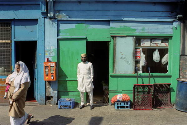
There was quite a lot of fine work in shop windows in London, particularly in areas in the north east with large Greek, Turkish, Kurdish or Cypriot heritage communities.
Southend Rd, North Circular Rd, Walthamstow Ave, South Chingford, Waltham Forest, 1995, 95c02-335
The North Circular Road runs across the borough and is a significant barrier to movement with relatively few bridges crossing it. Getting to places just over the road can mean a significant detour for people on foot. This fine 1930s building was a dairy company which delivered milk over a wide area. It has now lost its green tiles and is a Holiday Inn.
More in a later post. You can also find black and white pictures I took in the same area in 1995, starting on page 5 of my album 1995 London Photos.
Car Park, Angel, Works, Off-Sales, Co-op & Carnival Hats: I started my walk on Sunday 5th November 1989 at Walthamstow Central Station, and walked west down Selbourne Road.
Car Park, Selbourne Rd, Vernon Rd, Walthamstow, Waltham Forest, 1989 89-11b-15
This is Sainsbury’s multistory Car Park on the corner of Selbourne Rd and Vernon Rd and there is a very solid looking rectangular box brick building under the curves of the incline up to the parking space, with anther rectangle, the back of the sign and a very small circle of a car tyre at the extreme right.
I think I walked into Walthamstow cemetery to photograph the chapel there which I’ve not digitised but I also photographed several memorials including this one which I think attracted me because of the feathers on the wing and roses.
There is still a Lennox Trading Estate here, and I think the same gates, although the writing on it is smaller and more regular but otherwise everything looks much the same.
Lennox Road is a short street and its southern side has no buildings but simply the fence of Thomas Gamuel Park, which was re-designed in the 1990s. So the consecutive numbering 82-83 made some sense. The area to the west of the trading estate and the park has been comprehensively redeveloped with low rise housing around Lennox Road.
Thomas Gamuel “was a rich London grocer living in Walthamstow who bequeathed six acres of land known then as Honeybone Field and Markhouse Common, to six trustees, so that rent and profits from this land would be paid to the poor of the parish.”
Chelmsford Road runs down the east side of Thomas Gamuel Park and this former off-license on the corner looked as if it had recently closed with a notice on its side ‘SHOP / YARD & GARAGE STORE TO LET NO PREMIUM’.
The sign and the lamp at the corner suggested to me it had once been a pub rather than just an off-licence though the building seemed too small, but I can find no evidence for this. Both these and the shop front have now gone and the property is now residential including a first floor flat.
Former Co-op, Hoe St, Walthamstow, Waltham Forest, 1989 89-11d-42
I walked down Collingwood Road into St Barnabas Road where I photographed the Safford Hall and the church (not digitised) and then made my way north to Queens Road to cross the railway line and get to Hoe Street, where I made this image.
The beehive was a common cooperative symbol and appears several times on this building along with its date, 1915. For many years it was all the London Co-operative Society store but now only a small section at the northern end is a part of the Co-op, Wathamstow Funeralcare. The London Co-operative Society was formed in 1920 by the merger of the Stratford Co-operative Society and the Edmonton Co-operative Society and I think this was built for the Stratford society.
A few yards north along Hoe Street I took a couple of pictures of the business on the corner with Albert Road
I loved the detailing here with a rather glum looking face holding up a column beside the door. Unfortunately I can’t read the first word of the name of the company here from the angle I photographed this or the next frame, just DISTRIBUTORS LTD. But it did seem a slightly unusual trade to be WHOLESALERS OF CARNIVAL HATS & NOVELTIES.
This property is now entirely residential a has a new fence on top of a low wall around it with a small garden area.
House, 62a, Stroud Green Road, Finsbury Park, Haringey 1989 89-11d-45
At this point I went to Walthamstow Central Station and took the Victoria Line to Finsbury Park. I can’t now remember why I decided to move to a different area but perhaps I simply thought the park at Finsbury Park would be a pleasant place eat my sandwich lunch. I left the station by the Wells terrace entrance and walked along to Stroud Green Road.
As well as the slightly unusual doorway, it seemed to be almost barricaded by the plants growing in front to the door, but the stairs on the outside suggested an alternative entry.
St Peter & St Paul, Church, 121, Plough Road, Battersea, Wandsworth, 1989 89-8c-74
I left the riverside and walked down Lombard Road and crossed York Road into York Gardens probably to find a pleasant spot to rest a while and eat my sandwiches before going through the gardens to exit on Plough Road close to the church.
St Peter’s Church is still very much alive now on Plough Road, but SPB looks very different to my picture in 1989. The first St Peter’s Battersea was built in 1875 but was seriously damaged by fire in 1970 and the church moved into the building in my picture which had been its church and school hall.
According to ‘Clapham Junction Insider’ Cyril Ritchert, the demolition of this Grade II listed building, “an accomplished example of the free gothic style“, was opposed by the Ancient Monuments Society, English Heritage, the Battersea Society and the Wandsworth Society but was approved by Wandsworth Council in 2010. The developers made a second application in 2015 before any building on the site had started. Google Street View shows the church still in use in 2012.
To finance the new church the developers had been granted permission for an 8 storey block of flats also on the site. Local residents were angered that the developers managed to game the planning system to eventually build a 10 storey block of housing with minimal affordable housing on the site.
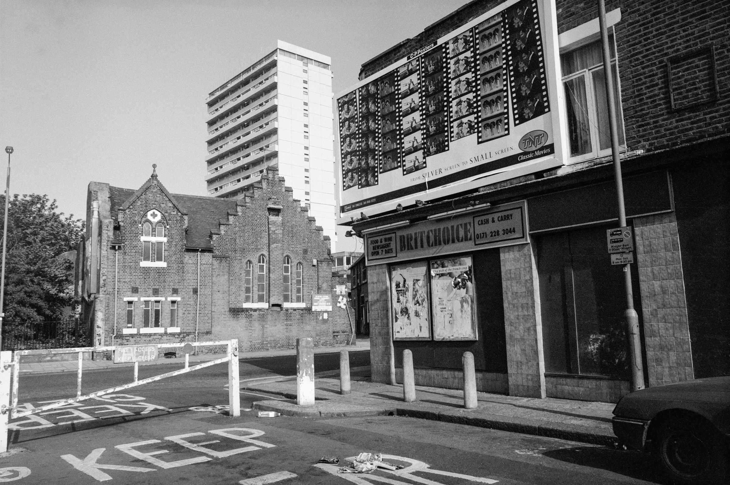
Shop, St Peter & St Paul, Church, Flats, Holgate Ave, Plough Rd, Battersea, Wandsworth, 1989
The view of the church from Holgate Avenue shows clearly the position of the church on the edge of the Winstanley Estate to the north of Clapham Junction station. The view of the tower block Sporle Court is now blocked by the new 10 storey block on the church site. The trees at left are in York Gardens.
There is still a billboard and a shop on the corner of Holgate Avenue, but what was then BRITCHOICE is now SUNRISER EXPRESS POLSKI SKLEP. Holgate Avenue was until 1931 known as Brittania Place or Brittania Street and took its name from the Brittania beer house which was possibly in this shop, part of a group of two buildings at 38-40 Plough Lane which are the only remnants of the original 1860s development of the area.
Apparently the Revd Chad Varah, the founder of The Samaritans, was vicar at Saint Peter’s during the 1950’s. St Peter’s was amalgamated with St Paul’s at some time after 1969 – and St Paul’s had been amalgamated with St John in Usk Road in 1938.
According to the Survey of London, “Holgate Avenue, started in the 1920s, was Battersea’s first successful slum-clearance scheme.” Poorly built Victorian houses from the 1860s were replaced by these three-storey tenements built by Battersea’s Labour Council in 1924-37 to high standards with some impressive brickwork and detailing. Probably more importantly for the residents they were provided with electric cooking, heating and lighting facilities, unusual luxury for the time.
There was little land in Battersea for building and while the council would have liked to build single family homes it had to compromise with these. But at least tenants at most had only to walk up three flights of stairs, while most new council building by the LCC in the interwar period was in five-storey tenement walk-up blocks.
Price’s Candles, York Rd, Battersea, Wandsworth, 1989 89-8c-62
I walked back up Plough Road to York Road, and continued my walk towards Wandsworth Bridge. There was no access to the River Thames on this stretch before the bridge, as the area was still occupied by industrial premises.
Price’s Candles on York Rd was built on part of the site of York House, the London residence of the Archbishop of York from which York Road got its name. You can read more than you will ever want to know about York House in All about Battersea, by Henry S Simmonds published in 1882 and now on Project Gutenberg, which also has a long section on the Belmont Works or Price’s Patent Candle Factory.
Price’s Candles was begun in 1830 by William Wilson and Benjamin Lancaster who had purchased a patent for the separation of coconut fats. They chose the name Price for the business to remain anonymous as candle-making was not at the time a respectable occupation.
They moved to this site in 1847 setting up a large factory and workforce, making candles, soap and other products with stearine wax for the candles and the by products of glycerine and light oils coming cocunuts grown on a plantation they bought in Ceylon. In 1854 they began to import large quantities of crude petroleum from Burma and developed paraffin wax candles. Later they developed processes to work with other industrial wastes, animal fats and fish oils. By 1900 they were the largest candle manufacturer in the world.
The company was taken over by Unilever in 1919, and became owned by other oil companies including BP, who sold part of the site which opened in 1959 as the Battersea Heliport. A few of Price’s buildings remain, though most with added floors, and the rest of the site is mostly new blocks of flats.
York Tavern, pub, 347, York Rd, Battersea, Wandsworth, 1989 89-8c-63
The York Tavern was on the corner of York Road and Usk Road in the late 1850s but was given a makeover later in the century in the typical 1890s Queen Anne style with fake gable facades. I can’t find a date for the closing of this pub but it was clearly very shut when I made this picture. The building was demolished in 2003.
John Watney & Co Ltd, Wandsworth Distillery, York Rd, Battersea, Wandsworth, 1989 89-8c-64
Wandsworth Distillery on York Rd was founded by Richard Bush at Gargoyle Wharf around 1780. By 1874 it was owned by John and Daniel Watney. Gin was produced here, having become popular after heavy taxes were imposed on French brandy, and later particularly in the colonies to counteract the unpleasantly bitter taste of the anti-malarial quinine.
Acquired by Guinness, the distillery was demolished in 1992, and I photographed its occupation as the ‘Pure Genius Eco Village‘ by The Land is Ours in 1996. It was redeveloped as Battersea Reach housing from 2002 on.
Tradescant, Old South Lambeth Rd and Caron continues my walk on Wednesday 19th July 1989 in Stockwell and South Lambeth which began with Stockwell Park, Bus Garage, Tower and Mason. The previous post was Clapham Road and South Lambeth – 1989.
Houses, Tradescant Rd, South Lambeth, Lambeth, 1989 89-7f-24
I took a picture (not on-line) on the corner of Tradescant Road, and then walked down it, pausing to take this single image on my way towards South Lambeth Road. I think I took this picture of an exuberantly growing hedge and a spindly small tree largely because I was thinking about the name of the street and the history behind it.
John Tradescant the Elder (c. 1570s–1638) settled in Lambeth and with his son John is said to have founded gardening as we know it in England, importing many of the trees, shrubs and plants we now grow.
He had begun his career as a gardener to the Cecil family, one of Englands richest and most politically influential families and had laid out the gardens at the Early of Salisbury’s new house, Hatfield House in Hertfordshire, travelling across Europe to find new plants for it. In 1617 he helped finance an expedition to the colony of Virginia, and among the plants this brought back was one later named Tradescantia virginiania.
John the Elder in the following years travelled to Russia, bringing back the larch tree, to Algeria coming home with apricots, gladioli and horse chestnuts, to the Middle East for Lilac, as well as to Italy and Turkey and later to France from were he introduced the poppy and scented stock. Later his son also travelled to Viginia bringing home many plants including Virginia Creeper and added to the collections which were exhibited to the public and sold from their nursery.
The family also set up the first public museum in England in the 1630s, the Lambeth Ark or Musaeum Tradescantianum, dsplaying the many curiosities natural and manmade they also brought back from their travels. Thee family were tricked out of this after the death of the younger John and his wife by the wealthy collector Elias Ashmole who later gave it to Oxford University as the main founding collection of the Ashmolean Museum.
You can see more about the family and their huge contribution to gardening at the Garden Museum which is next door to Lambeth Palace in the deconsecrated church of St Mary-at-Lambeth, where the Tradescants are buried.
The Tradescant’s main house, Turret House, was demolished in 1881 and two streets, Tradescant Street (now Road) and Walberswick Street (named after the Suffolk village where some of the family lived) laid out on the site.
Girl, doll, shop, South Lambeth Rd, South Lambeth, Lambeth, 1989 89-7f-25
On South Lambeth Road I came across this young girl sitting on a stool and playing with a doll outside her family shop. I didn’t want to disturb her and took this picture as she was lost in play.
House, 99, Old South Lambeth Rd, South Lambeth, Lambeth, 1989 89-7f-13
The demolition of the Tradescant’s house which apparently had been long-abandoned and overgrown South Lambeth Road in 1881 enabled the South Lambeth Road to be straightened and widened in 1883, leaving a section of the old road to the east, now known as Old South Lambeth Road. No 99-105 South Lambeth Road are Grade II listed as an early 19th century terrace, with the listing noting their graceful railings which attracted me.
As you can see at the left of the picture some of these properties were in a fairly poor state in 1989. This was then the side wall of a shop, now converted to residential use and in rather better condition.
Old South Lambeth Rd, South Lambeth, Lambeth, 1989 89-7f-14
This section of Old South Lambeth Road is named on Google Maps as Heyford Terrace, although I think this is simply this long row of 8 terraced houses on the east side of the street, separately numbered from the rest of this short road. I think they were built as terraced housed but are now flats and are late Victorian, built not long after the rerouting of the road in 1883.
The houses at the end of the road are in Heyford Avenue, I think also developed around 1890.
House, 119, Fentiman Rd, South Lambeth, Lambeth, 1989 89-7f-15
I walked down Dorset Road and then turned left into Meadow Road to take me to Fentiman Road where I made my next picture about a quarter of a mile later. I’m rather surprised I didn’t find anything to interest me in that distance.
This house is in one of two similar short terraces immediately west of the junction with Meadow Road and I now think is No 119. The eleven other houses have similar decorative elements though the gables are varied with three patterns. I think then that many now had vigorously overgrown front gardens like this making hiding much of the ground floors, though now some are cleared for parking cars.
House, 104, Fentiman Rd, South Lambeth, Lambeth, 1989 89-7g-62
The houses opposite on the north side of the road here are rather larger and detached. Those at 106-112 are listed as is the church on the east side of this house. I think I photographed this rather than the listed buildings as for the reflection in the car and the tree shadow in the lower part of the image.
Caron’s Almshouses, Fentiman Rd, South Lambeth, Lambeth, 1989 89-7g-63
A few yards further along Fentiman Road are Caron’s Almshouses, founded in 1618 by Noel Caron, Dutch Ambassador to the court of King James 1, and a popular local philanthropist who lived in South Lambeth.
Originally on Wandsworth Road, Caron’s Almshouses became unsuitable for elderly people and moved to these new buildings in Fentiman Rd in 1854. The buildings were leased to the Family Housing association in the 1990s and repaired and modernised for local women in need and officially reopened by the Dutch Ambassador in 1997.
I included these last two pictures in a post on a previous walk made two days earlier in 1989, and I’m unsure now on which of the two walks in the same area they were taken on.
Back in 1989 I was still pretty pressed for cash, still buying film in bulk 100 ft lengths and loading it into cassettes myself in total darkness.
Over the years I’d perfected my method. Two nails on the back of my darkroom door, hang one of the sprocket holes at the end of the roll of film on the top one, unroll it down to the second, cut across, replace film in can. Pick up first spool from a waiting row on the bench, already with a short length of masking tape on it, attach to the bottom end of the hanging length of film, carefully roll it up to the top, remove from nail, pick up cassette body, insert spool with film end though velvet light trap, pick up end cap and pinch cassette to push it into place. Repeat another 18 times until the film roll is finished. Turn on light, trim film ends to fit cameras and put into plastic pots to go into camera bag.
Slow, tedious but then less than half the cost of buying film in 26 exposure cassettes, though I did ocasoinally treat myself – and if I bought Ilford film rather than Kodak I could reuse the cassettes with bulk film. Kodak had crimped on ends which had to be removed with a bottle cap remover destroying them.
I had learnt to be very careful with film in this project to photograph London, working with 35mm cameras much as I would have done with large format camera, carefully considering various viewpoints before deciding on an exposure. But when working with people I had to respond rather more quickly, and seeing these two men in front of the white church door my response was immediate.
After that rather snatched image I continued with photographing the two shops which had attracted my interest here, making first a vertical image and then moving back across the road for a wider view. In this (below) you can see the notice for the Celestial Church of Christ and the alley leading to this.
As well as these black and white images I also took a couple in colour which you can see in another album. I had two Olympus OM bodies with me and only brought the one with colour negative film out of my bag occasionally, while the black and white camera was usually on a strap around my neck. When I was intending to photograph people rather than buildings I usually went out with a Leica M2 instead.
Coldharbour Lane leads from Camberwell to Brixton and got a very bad reputation after the 1981 clashes between police and locals in Brixton. In 2003 it was called in an article in the London Evening Standard the most dangerous street in the most dangerous borough in London, but that was lagely rabid tabloid journalism. Wikipedia gives several theories about its name none of which seem entirely convincing, but the name seems often to have been associated with the ruins of Roman or Romano-British settlements, The area we know usually call Loughborough Junction around the station on early maps was called Cold Harbour. Coldharbour Lane was then known as Camberwell Lane.
The S&J Corner Café was on the corner with Wellfit Street, close to Loughborough Junction station. The railway line here is just south of the station. A second bridge can be seen going above this and the cafe which is the line from Brixton to Denmark Hill, now used by London Overground services.
Another picture I took on the spur of the moment as I saw a cyclist coming towards me under the bridges on Hinton Road. I was standing on the pavement beside the cafe in the previous image, and the cyclist is on the pavement, rather safer than roads like this in London. At the end of the row of shops on the left are the traffic lights and Coldharbour Lane whch I had just begun to walk towards.
Hinton Rd, Camberwell, Lambeth, 1989 89-4j-52
The pub at right of this picture is The Green Man on the corner with Coldharbour Lane. According to a post on the Brixton Buzz, this had been on the site since 1881, but that is the date of the current building which replaced an earlier pub on the site important enough to be marked on Stanford’s 1862 map. The Buzz says it was closed in 2003 because of drug dealing and crime, and it quotes from the Urban75 blog that it was “was frequented by dealers (crack, heroin you name it), prosi’s and general madhatters.“
The buildings at the left date from around the same time as the area was developed around the railways, and number 6 at left has a barely legible road name ‘Hinton Terrace‘ and I think at the top the illegible name of a builder and decorator whose sign presumably once hung on the bracket beside the street name.
I walked up past Loughborough Junction and made my next picture on Lilford Road at the corner of Minet Road, returning to the area I had been earlier on this walk, the Minet Estate around Myatt’s Fields. This is on the corner of a terrace with basement flats with an entrance here under the steps which extends along both streets and this grand entrance is actually for two adjoining houses above the flats, one on each street. The Grade II listing calls these “Early-mid C19″ and describes this a “double prostyle composite porch with fluted composite columns.”
William Minet founded this Grade II listed community hall, architect George Hubbard, which opened in 1889, as well as the Minet library opposite which was destroyed by bombing and rebuilt in 1956 in what Pevsner described as ‘a meek replacement’. The Library was a memorial for his late wife. The Hall is still in use for various community activities including three church congregations and from 1969 -1975 was the base of Britain’s first Black Theatre Company, ‘Dark And Light’, recently marked by a Blue Plaque. It was Grade II listed in 1979 and is now run by a charity, The Longfield Hall Trust.
My walk made on on Sunday 9th April 1989 will finish in a later post. The first part from it is at Peckham and East Dulwich 1989.
The day after my walk around King’s Cross, in part on a walk led by GLIAS, on Sunday 9th April 1989 I was back in London on my own, south of the river for a walk beginning in Peckham.
People have often asked my why I photographed the areas of South London, and although I tell them I also photographed the North, East and West, my interest was certainly was certainly inspired by a remarkable book, London South Of the River, by Sam Price Myers, published in 1949, illutstrated by some fine wood engravings by Rachel Reckitt.
Back in 1989 there was relatively little graffiti in the area, but much of the walls in the 1930’s building at the centre of the picture where an arcade leads left towards Rye Lane was covered fairly colourfully last time I visited. You can just see a little of the station at right through the first arch. The second arch on Station Way leads to Blenheim Grove,
Myers does not have a great deal to say about Peckham, but has an engaging enthusiasm for the subject matter. His short section on the area does, like me start at Peckham Rye Station, though I had probably not arrived by train but on a bus to Peckham from Vauxhall. The book also contains some decent photographs, though greatly weakened by the rather pallid reproduction of the era, by a number of photographers including Ursula Hartleben and Bernard Alfieri.
My copy, bearing the stamp of the Illustrated London News Editorial Library, was certainly £4 well spent, and I find a copy in rather better condition now offered for sale on the web for £555; the advert shows several of Reckitt’s illustrations, and another was posted by a friend on Twitter. You can still find copies of the book in similar condition to mine for a rather more reasonable price.
This picture is looking north up Station Way from outside the station entrance towards Holly Grove. My interest on this occasion was obviously rather more in the 1930s building than the Victorian station,
Shop, Blenheim Grove, Peckham, Southwark, 1989 89-4h-21
This was another part of the 1930s development in front of the station between it and Rye Lane, here with shops and flats above. I walked the few yards east into Rye Lane and continued south down this, taking few pictures as I had photographed this area on previous walks.
Continuing south, Rye Lane merges into Peckham Rye, and I often confused the two. The numbers on the door frame here are 257-261 and this was a part of the former Co-Op building at the bottom of Rye Lane, now demolished and replaced.
The giant lock with its legend YALE LOCKS was became labelled the entrance to Ezel Court (which I think was just the flats above the shops), but I assume that at one time either 56 – here dealing with pets – or the shop to the left had sold locks. In recent years these have become a Mini Super Market and a restaurant. I had photographed this earlier in the year and another picture appears in my post Peckham Rye to Goose Green – 1989.
Houses, Kelmore Grove, East Dulwich, Southwark, 1989 89-4h-13
I continued down Peckham Rye to the junction where I turned to the west along East Dulwich Road. In 1879 this there were really substantial villas along the south of East Dulwich Rd, but by the early 90s Oakhurst Grove, Kelmore Grove and The Gardens at the back of these had been laid and lined with substantial family homes.
These beautifully decorated late Victorian houses are on the south side of Kelmore Grove, with slightly plainer examples on the other side of the road. Although only two storey, these are substantial semi-detached houses with a wide frontage with a large room on each side of the central hallway.
Houses, Oakhurst Grove, East Dulwich, Southwark, 1989 89-4h-14
The houses in Oakhurst Grove have alternate bays and rather curious towers in what are semi-detached three storey houses. The two doors in each pair are adjacent with only a room on one side and although taller they are less grand than those in the picture above. But they also have some fine brickwork and decorative elements.
Intercity (East) Ltd, Clothing, Shop, City, Tower Hamlets, 1989 89-3e-42
I was on my way to the East End, and I’m no longer sure where this shop was located, although my contact sheet has Cutler Street, it also has a question mark in front of this. I will have marked up the contact sheets while I still remembered my route (and had probably marked this on a map more or less after I got home) so I will have walked this way towards Leyden Street where I made the next picture. But all I can find on Google about Intercity (East) Ltd is not about clothing stores but trains.
Cutler Street begins on Houndsditch and I think both corners there have been demolished and rebuilt since 1989. It has two more corners where it turns 90 degrees to the right in front of Cutlers Gardens, again both now occupied by more recent buildings.
From Cutler Street I went up Harrow Place and crossed over Middlesex Street into Cobb Street, going out from the City of London into Tower Hamlets. Much of the area I went through has since been redeveloped but unfortunately I took no pictures.
Blue Bird, a wholesale children’s clothing cash and carry was a shopfront I also photographed in colour on this same walk. This building remains, though was extensively renovated internally around 2020 and 6 at right, Dunmow Trading, is again apparently in the clothing trade, though perhaps the renewed shopfront is a nod to the past hiding some completely different activities.
This was a frontage I passed and photographed several times over the years, but never went inside. Founded in 1854 in Leman St, the Soup Kitchen for the Jewish Poor moved to Brune Street (then Butler St) in 1902 and eventually closed in 1992, its work being carried on by Jewish Care in Beaumont Grove, Stepney. I had assumed it was now longer operating when I took this picture in 1989.
Another shopfront I photographed on several occasions and in colour, and it was hard to decide which if any of the businesses were still in operation. Now the whole area has been tidied up and shops like these converted to slightly twee ‘period’ residential properties.
This early 18th century Grade II listed terrace house was sold in 1998 for £236,000, probably just before or after conversion, and in 2021 sold for £3.5million.
The fine row of houses on the south side leading up to Christ Church was still I think occupied and possibly in use by firms in the clothing trade, with M Lustig & Co, Manufacturers of Superior Mens Clothing, Dilal Fashions at No 10 and Gale Furs at 8. Though their days were clearly numbered and all are now high priced residential properties and maintained in considerably better condition. I think all of the street is Grade II listed.
Christ Church is one of Hawksmoor’s masterpieces, built 1723-9 and Grade I listed.
Established in 1902 and supplying textiles and trimmings to the fashion trade, in 1998 J Minsky sold its warehouse premises and began to focus on property investment, selling the textile business in 2005. This was 48 Fashion Street, which is a part of a listed building, but it is very difficult to recognise in this picture, which managed to avoid its more distinctive features, with just the slightest hint on its upper edge.
Twelve years ago on 17th February 2011 I attended the opening of the show London Street Photography at the Museum of London, and I wrote about the opening here on >Re:PHOTO. Some of the same pictures there are also on My London Diary. The book of the show is long out of print but can be found cheaply secondhand with a little searching.
I was rather surprised to find this particular picture of mine, taken in Whitechapel in 1991 included in the book and show, and also one of the images used to promote the show. Not that I think it’s a bad picture, but to me it was just one of many that could have been chosen. I’ve never really put together a set of what I think are my best street photographs, but here are a few slightly random ones from about the same year.
I actually made two pictures of the shopkeeper standing outside the shop in Whitechapel, and the woman carrying a child walked across as I was talking to him and preparing to take his picture. I think I was just a little slow to react, and would have liked her to be just a fraction to the left, better outlined against the open doorway and for the child she was carrying to be more visible.
Perhaps important to the show was that most of the others from that era and before were in black and white – as most of photography still was. Only one earlier colour picture was featured, although most more recent work was in colour, including all of those taken in the current century.
Also important was that it reflected the changing population of London with a picture that could almost have been taken on the streets of Bangladesh – but so did some others that I took at the time.
Notting Hill Carnival, Notting Hill, Kensington & Chelsea, 1990, 90c8-03-51
I’ve recently re-digitised this and digitised many other colour and black and white images from my early work and made them available on Flickr, though so far I’ve only worked through all of the colour negatives up to the end of February 1991 and the black and white until the end of the following year.
Street scene, Green St, Upton Park, Newham, 1991, 91-31-31
Although almost all of these pictures were taken on the streets of London I don’t think many are really what I would consider ‘street photography’, though this is a category whose elasticity makes it of little use. But for me ‘street photography’ has to be about capturing fleeting moments, not about pictures that are posed or set up. The second picture without the woman walking by isn’t really street photography.
Back in the 1930s there were at least five Albert Roads in London, along with a number of Albert Streets, Albert Mews etc and the authorities embarked on an orgy of renaming to sort out the confusions that could arise. Albert had been particularly popular after Prince Albert of Saxe-Coburg and Gotha had married Queen Victoria in 1840 and at the time of his death in 1861, and some, such as Consort Road, were renamed to reflect their original dedication.
15 Consort Road is Grade II listed and described as “Mid C19, recently restored” and it rather looks as if my picture was taken during that restoration, with the house in excellent condition but the garden rather lacking. Its listing is perhaps more about its part in a group of similar houses rather than its individual merit, and 11,13 and 17 are also listed.
Rather better known now is its new neighbour, 15 and a half Consort Road, an long, low and unobtrusive house now alongside the right hand side of this house with a wood-covered frontage extending a little closer to the road. From the front it rather looks like a garage which someone forget to put in the door, but it was a truly innovative building by Richard Paxton Architects in 2002, shortlisted in the RIBA Awards 2006, and featured on TV’s Grand Designs.
Two railway lines with three bridges cross Consort Road just a few yards from each other, one leading from Peckham Rye to Nunhead and the other from Peckham Rye to Queen’s Road Peckham, along which is now planned to build an urban linear corridor park, the Coal Line, which I visited in 2015.
The bridges and the area around them have changed considerably since 1989. But I think the viaduct is of the line to Nunhead and this house on the edge of the workhouse site has since been demolished.
Limited were in a post-war building on Consort Road just a little south of the railway bridges and I think they made waterproof products using rubber on glass cloth. Their building replaced some older Victorian terrace housing, some of which was still there at the right when I made this picture. I think the company under a slightly different name is still in business elsewhere.
These buildings have all been replaced by modern flats and an industrial unit.
This shop was obviously on a street corner, almost certainly one of the four corners with Consort Road and Brayards Rd. I was interested in the shapes and the tiling as well as the fly posting and crude graffiti – which appears to be two practices at producing the final result at right, perhaps a stylised ’68’. The doorway with a rusticated keystone seemed unusually tall and narrow. It was probably Victorian although the shopfront seemed later.
The Gold Diggers Arms was a sizeable pub on the northeast corner of Brayards Road and Consort Road and was still in business when I made this picture. It had been here since at least 1871, but closed in 2001 and was demolished in 2005. The site is now a modern development, Dayak Court, flats above ground floor commercial premises.
The Hooper Hall, Consort Rd, Peckham, Southwark, 1989 89-2f-53
Hooper Hall at 111 Consort Road opened as a mission of St Mary Magdalene in St Mary’s Rd in 1907, which was destroyed by a land mine in 1940. Worship continued here and in the church hall while money was raised to build a new church, opened in 1962 and itself replaced in 2011. The mission has lasted rather better.
A notice tells us that in 1989 it was used by both St Mary Magdalene and the Peckham Christian Fellowship. Later it became home to the Christ Miracle Gospel Ministries International but was put up for sale in 2012, and I think the church moved to Edmonton. A fence was put up around Hooper Hall around 2015 as if building work was about to begin, but little seems to have happened since. It appears still to be available for sale.
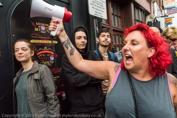
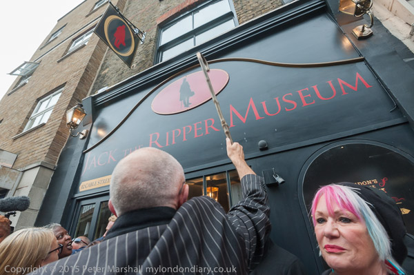
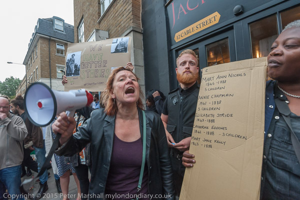
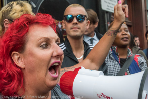
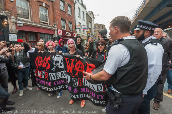
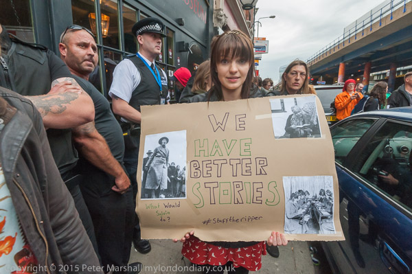
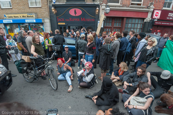
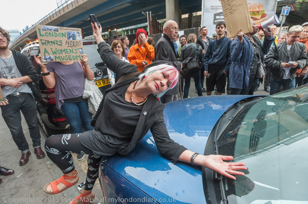
Class War and others protested on Wednesday 5th August 2015 outside the newly opened Jack The Ripper “museum” in Cable St days after it first opened. Class War had called this protest as soon as the news became public, and others had organised another protest the previous evening which I had been unable to attend. Class War later organised further protests outside the museum which I also photographed.
Unfortunately the Jack the Ripper tourist attraction in Cable Street is still open, pandering to a popular taste, particularly among tourists to the city, for the sensational and to wallow in the grisly details of this brutal and horrific series of murders in London of five working-class women on the streets of Victorian London.
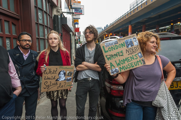
The museum was set up according to its planning application as the “first women’s museum in the UK” which “will recognise and celebrate the women of the East End who have shaped history, telling the story of how they have been instrumental in changing society.” A number of people gave advice or worked for free or at cost because they supported the project on this basis, and felt disgusted at how they were duped.
As I commented in 2015, ‘People who have seen the museum have been revolted at its sensational presentation of violent crimes against women. One of the politer comments was to call it “salacious, misogynist rubbish.“‘
I’ve only seen the shop through the doors and windows, and there does seem to be a lot of merchandise for sale. The on-line reviews of the place are extremely polarised. There are many positive, even fawning examples, though some do seem to follow a very similar pattern.
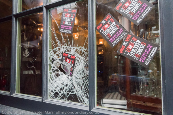
I think the window had been smashed earlier in the day
Others are damning. One comments “The museum is pretty small. It’s effectively 5 small rooms. You could whizz round it in 10 minutes easily. In no way does it represent good value for money. One of the rooms was pure conjecture too (What Jack the Ripper’s living room might have looked like…!?). It’s rather light on any kind of detail. For people with anything more than a superficial interest in the history etc, this is a waste of your time and money.”
Another states “I have no idea how it got so many positive reviews… It’s £12 per person and we’ve basically seen everything after 10 minutes. There’s nothing in this museum that isn’t already in the Google images.” Others are far more negative about the exploitation of the sadistic murders of women for profit.
So if you are someone who thinks we should celebrate the work of a serial killer who eviscerated five defenceless women – three of them mothers – on the streets of London and feel your holiday would not be complete without wallowing in more of the bloody details you may well enjoy this “museum”, even though it is in the wrong location and has little authentic content.
If you are not sure about the details of the killings and have a strong stomach you can read more, rather too much more, on Wikipedia; it isn’t pleasant reading. For once I’d advise you not to click on the link, or if you do to skip some parts of the entry.
Of course the whole Ripper industry is a tacky area, with many more imaginative and profitable books speculating on the identity of the deranged killer. Although the evidence is only circumstantial the most likely suspect remains Montague Druitt who committed suicide shortly after the last of the five murders, and was one of three named in a letter written five or six years later by a senior police officer who though not involved in the investigation will have had access to the officers and the – now largely destroyed – police records of the case.