Posts Tagged ‘pubs’

No Third Runway at Heathrow – 2016

Tuesday, May 30th, 2023

No Third Runway at Heathrow

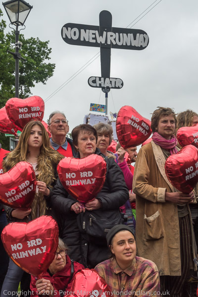
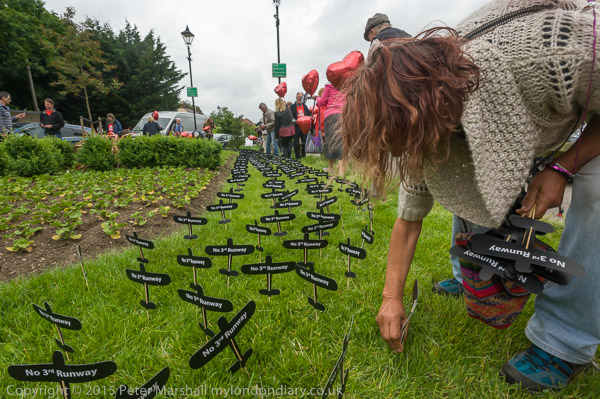
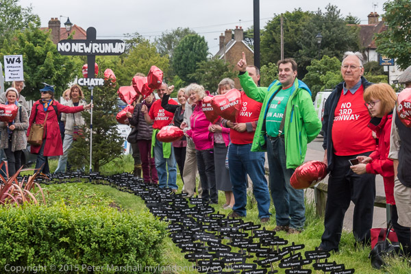
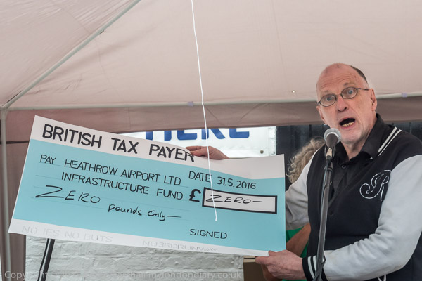
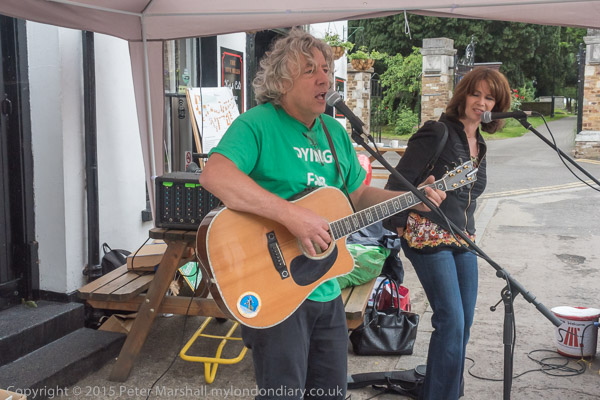
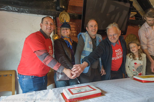
No Third Runway at Heathrow: Heathrow Airport celebrated its 70th anniversary on Monday 30th May 2016. and local residents marked the occasion with a protest on the village green at Harmondsworth against the plans to build a third runway which would destroy over 750 local homes.

No Third Runway at Heathrow

I grew up under the flightpath a couple of miles from touchdown on the main runway used for incoming flights, standing in my back garden and crossing off the registration letters of the planes passing rather close overhead in my spotters book. Those early planes – like the Douglas DC3 and the Vickers Viscount – were small and relatively quiet and gave young boys like me hours of interest with little disruption of normal life, but the generations that followed were very different, larger and ear-shattering. The complaints against their noise grew rapidly – and those easy to read letters on the underside of the wings disappeared so it was harder to identify flights in our complaints.

No Third Runway at Heathrow

Heathrow had been planted on the edge of London’s built up area by deception, beginning as a ‘military’ airport towards the end of the Second World War when it was known it would never be used as such, by people who were determined to make it London’s major civil airport. They did it to get around the objecteons there would have been later to a civil airport here.

No Third Runway at Heathrow
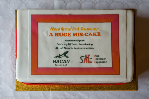
A huge mis-cake’ Heathrow Airport: Celebrating 70 years of unrelenting Aircraft Noise for local communities’

Over the years Heathrow continued to grow and grow. More flights and more terminals. More local traffic and more pollution. Every new development was made with promises that were later broken. T4 was promised to be the last new terminal – but then came the application to build T5. With this came the promise that Heathrow would never ask for another runway – but this was broken even before T5 had opened.

The enquiry into the third runway was said to be final – but while the local community were still celebrating their victory – and David Cameron was saying ” No Ifs, No Buts, No Third Runway”, Heathrow Airport was already plotting the setting up of a new inquiry that would somehow against all the evidence come up with the result they wanted – the Davies Commission.

John Stewart – HACAN – Heathrow want taxpayers to pay for the new roads, tunnels etc needed

In 2016 the threat of the new ‘third runway’ loomed dangerously over the area again, with the Conservative Government backing the proposals. Many of those who came to the event at Harmondsworth feared they would soon lose their homes – and property in the area was blighted as it had been for many years. Others outside the actual development would find their lives made impossible by aircraft noise, with people from almost the whole of West London suffering, particularly from flights in the early morning, with plane after plane passing overhead.

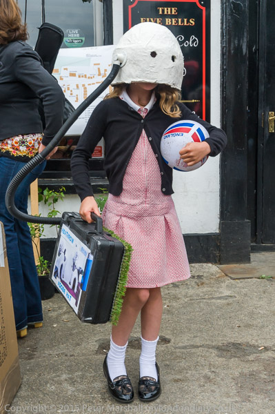
The Heathrow Adobe Hat, with portable air purifier and environmentally biodiverse suitcase

Heathrow’s noise and pollution affect a surprisingly large area of London. Twenty years ago I was in a hospital bed in Tooting in south London, around 12 miles away as the jet flies, awake early in the morning partly by their noise, watching and hearing a whole line of plane after plane in line for touchdown.

Neil Keveren, Chair of Stop Heathrow Expansion (SHE)

In our local area we get the pollution from the planes, both from running their engines on the ground and also from takeoff and landing. But more importantly the airport generates huge amounts of road traffic, both on local roads and the motorways serving the area – M3, M4 and M25.

Seven years on it seems increasingly unlikely that there will ever be a third runway built. Even the most jet-headed politicians are beginning to see that we cannot continue with airport expansion and meet the need to cut carbon emissions. Financial constraints increasingly make it less likely too.

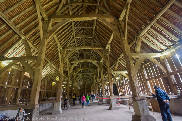
My post on My London Diary has the details about the event on Monday 30th May 2016 and of course more pictures, including some of the village itself, including its pubs, church and remarkable Grade I listed tithe barn, said to be the largest wooden structure in the country, dating from 1426. Local campaigners saved that a few years ago and it was bought by English Heritage in 2012 and has been much restored. It lies just outside the area the airport would take over for the new runway and would be at serous danger from vibration – and would almost certainly need to be re-sited.

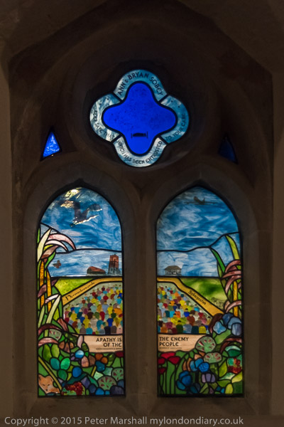
A church window remembers Ann & Bryan Sobey who led the ‘Right to Sleep’ campaign for restrictions on night flights into Heathrow

Though on the edge of London Harmondsworth still has a village atmosphere, and still seems much like the village I cycled through in my youth. I hope it remains that way.

More at No 3rd Runway Heathrow 70th Birthday.


A Pub, Ghost Sign, Shops And The Sally Ann

Saturday, December 10th, 2022

My next opportunity for a walk in South London was on Sunday 5th February 1989 a week after my previous walk. I returned to Camberwell, getting off the bus from Vauxhall on Peckham Road at Camberwell Green and walked down Grove Lane.

The Grove House Tavern, Mary Boast Walk, Camberwell Grove, Camberwell, Southwark, 1989 89-1i-12

At the end of an alley leading to Camberwell Grove I found the Grove House Tavern, then a Taylor Walker pub. I liked the way its chimney seemed to complement the spire of St Giles’s Church on the other side of my frame and the rather elegant pair of houses facing the end of Mary Boast walk at 53 and 55 Camberwell Grove, both Grade II listed along with many other houses on that street.

Mary Joyce Boast (1921-2010) was a local history librarian, and became a great expert on the history of Southwark. She was the borough’s first Local Studies Librarian, but had retired a few years before I first visited the John Harvard Library on Borough High St. I think this passage was unnamed when I took this picture and only got a name after her death in 2010.

The fence at left stops the balls for a tennis club. There was a pub on this corner in 1826, though the building in my picture dates from around a century later and has a rather unusual Mansard roof. For a while it became the Grand Union, but was renamed Grove House in 2017 and was taken over by new management in 2021.

Gone Fishing, Shop Door, Denmark Hill, Camberwell, Southwark, Lambeth, 1989 89-1i-15

The curved building reflected in the glass here is the former Odeon Cinema on the corner of Coldharbour Lane. I had walked back up Grove Lane and then along Daneville Road to here. The handwritten sign ‘CLOSED EARLY – Gone Fishing’ seemed to me to reflect a very healthy attitude to life.

Shop, Ghost Sign, Daneville Rd, Denmark Hill, Camberwell, Southwark, 1989 89-1i-16

Looking back up Daneville Rd from the corner with Denmark Hill I photographed the faded wall sign for DAREN, the Best Brown Bread. Only faint traces of this ‘ghost sign’ now remain. The ‘lower ‘Great Expectations’ section was painted over in white and then around 2010 with a colourful graffiti mural, perhaps related to the GX Gallery to its right down Daneville Road. Later this too was painted over, and became ‘Muhammad Ali’ after his death in 2016, only to be over-painted again more recently.

‘Daren The Best Brown Bread’ was a non-wholemeal brown loaf baked from flour ground at the Daren Mill at Dartford in Kent, at the time it was painted as big a brand as Hovis. The mill went bankrupt in the 1930s and the brand merged with Hovis. Personally I think their loaves are rather like eating sawdust and stick to proper wholemeal, fortunately home-made.

Former Odeon cinema, Denmark Hill, Coldharbour Lane, Camberwell,  Lambeth, Southwark, 1989 89-2a-01
Former Odeon cinema, Denmark Hill, Coldharbour Lane, Camberwell, Lambeth, Southwark, 1989 89-2a-01

Looking across Denmark Hill with Coldharbour Lane and Valmar Ave visible at right. The Odeon here was the largest Odeon built in London and opened in 1939, seating almost 2,500. It had entrances on both Denmark Hill and Coldharbour Lane, and had shops on the corner here. It closed in 1975 and was empty until taken over briefly in 1981 by Dickie Dirt selling cut-price jeans and other clothing. But they went bust and the former cinema was empty for another ten years until demolished in 1993, when a block of flats for homeless young people was built on the site.

Tony's Corner Shop, 108a Denmark Hill, Camberwell,  Lambeth, 1989 89-2a-61
Tony’s Corner Shop, 108a Denmark Hill, Camberwell, Lambeth, 1989 89-2a-61

Tony’s is still there on the corner of an alley off Denmark Hill, though the former cinema which housed the Camberwell branch of Dickie Dirts which can be glimpsed at top right has been replaced by a block of flats. The alley, Coldharbour Place, leads through to Coldharbour Lane. There are no longer windows on the side of the shop which is covered other and now painted with graffiti.

House, Grove Lane, Camberwell, Southwark, 1989 89-2a-63

I think I may have been attracted by the name to walk down Love Lane, though I took no pictures on it. On Grove Lane I photographed Cliftonville at No 83, a Grade II listed early 19th century villa with rather unusual ogge or ogive curves on the door and windows.

William Booth College, Salvation Army, Champion Park, Denmark Hill, Southwark, 1989 89-2a-66

I walked down Grove Lane and turned right into Champion Park to admire the Salvation Army’s William Booth College. Designed by Sir Giles Gilbert Scott, the college opened in 1929 and is a memorial to William Booth who died in 1912. It was completed in 1932 and has a similar monumental impressiveness to Scott’s power stations at Battersea and Bankside (now Tate Modern.)

The simplicity of this building was not by design but because of budget cuts which fortunately meant that originally planned Gothic stone detailing could not be afforded. This resulted in the Grade II listed building becoming a spiritual power station. It has recently been renovated and is still in use by the Salvation Army.

Catherine Booth statue, William Booth College, Salvation Army, Champion Park, Denmark Hill, Southwark, 1989. 89-2a-41

Mrs Catherine Booth was the wife of William Booth and co-founder with him of the Salvation Army. Known as ‘The Army Mother’ she died – or rather was ‘Promoted to glory October 4th 1890’. This sculpture by George Wade was erected in front of the new college in 1929.

This picture shows more of that Gothic stonework details that were meant to be rather more widely applied.


This walk will continue in further posts.


Staines 1987

Saturday, March 6th, 2021

My photographic projects in London relied on being able to get a train from Staines, and although the service was generally rather better back in the 1980s than now, there were still times when I turned up at the station only to find there were no trains running. It was probably on one of these days when I’d arrived at the station with my camera bag on my shoulder that I decided instead of going back home to take a walk around the town instead. There is nothing spectacular about these images, but I think they are an interesting record of a time and place and one that in many respects has changed since I took them in October 1987.

Clarence St, Church St, Staines, Middx, 1987, Spelthorne 87-10i-51-positive_2400
Clarence St, Church St, Staines, Middx, 1987, Spelthorne

This corner has changed relatively little, but Johnson and Clark, the Staines department store said to have been the inspiration for a sitcom closed long ago, and its main building on the other side of the road not in this picture long demolished. It was a business which always seemed stuck in a 1950s time warp. The shop with a closing down sale at right had been Staines first supermarket, a small Tesco , but possibly it was a successor selling up; it is now a Wetherspoons, and the last pub I visited before the lockdown in December.

Market Square, Staines, Middx, 1987, Spelthorne 87-10i-41-positive_2400
Market Square, Staines, Middx, 1987, Spelthorne

The Blue Anchor was in business here, possibly from the 15th century, and the brick facade dates from 1721. Some of its windows are real but others only painted, presumably because of the window tax which first came into force in 1696 and was only repealed in 1851, and its hard to see the difference in this picture. One of the major inns in the old town, it closed as a pub around 2006, and has since been a series of restaurants, currently Turkish and of course only able to serve takeaway meals.

Staines Town Hall was built in 1880, financed by public subscription and the building became redundant when Spelthorne Council built new offices around a mile away – and at roughly the same time was Grade II listed. For some years it was used only for occasional concerts (and is the courtroom in the 1982 film Gandhi) but the council spent £1 million to convert it into a much-needed arts centre in Staines which opened in 1994. But this lost money and was closed in 1999 being at the wrong end of the borough to get support from the Tory council. It reopened as a wine bar from 2004-12, then was left empty (apart from a brief squat) before being sold off to a developer for £1.6 million with planning permission granted in 2018 for conversion to flats despite there being no parking space and inadequate disabled access. Many Staines residents regard it as a scandalous loss of what should have been seen as a major public asset for the town desperately short of cultural facilities.

Cock Tavern, Church St, Bridge St, Staines, Middx, 1987, Spelthorne 87-10i-31-positive_2400
Cock Inn, Church St, Bridge St, Staines, Middx, 1987

The Cock Inn, built in 1832 on a site that had been a pub for several hundred years, closed in 2009 and is now offices. Behind it was Ashby’s Brewery, where a modern building for Courage can be seen peeping over and to the left, but it served Brandon’s Fine Ales, brewed in Putney. Some of the older Ashby buildings still stand, converted to residential and office uses and the Quaker Ashby family was one of the most important in the growth of Staines.

A second Staines brewery, on Kingston Rd, set up by the Harris family was taken over by Ashby’s in 1903 and closed in 1914. Later it briefly became Staines Library and then an adult education centre for Surrey County Council but was closed 15 years ago and has been empty and unused since. Squatters occupied it in 2015 attempting to open up the buildings for community use but were evicted after a couple of months.

Clarence St, Staines, Middx, 1987, Spelthorne 87-10i-26-positive_2400
Clarence St, Staines, Middx, 1987

Clarence Street was built as the approach road to the new Staines Bridge designed by John and George Rennie and opened by King William IV and Queen Adelaide in 1832, a short distance upstream of previous bridges thought to have crossed the river since Roman times close to the Market Square. It was the fourth bridge to be built since the Civil War and is still in use, widened considerably in 1958, but still a bottleneck. The building on the corner of Bridge St was in the 1970s Staines Library.

High St, Staines, Middx, 1987, Spelthorne 87-10i-03-positive_2400
High St, Staines, Middx, 1987

Staines High St is still lined by a few buildings of some architectural interest from the Victorian era, along with some rather less exciting 20th century additions, but the big difference is that it is now pedestrianised.

High St, Staines, Middx, 1987, Spelthorne 87-10h-11-positive_2400
High St, Staines, Middx, 1987

Another view of the north side of the High St, this time looking east towards the ‘Iron Bridge’ which carries the Windsor Line across the road. Almost all of the buildings here have now been demolished, with a large hotel replacing most of them.

London Rd, Staines, Middx, 1987, Spelthorne 87-10h-36-positive_2400
London Rd, Staines, Middx, 1987

The main road through Staines, on the line of the Roman Road to the Southwest which became the A30, becomes London Road to the east of the Iron Bridge seen at the left of this picture. Fortunately the opening of the second section of the Staines bypass in the 1960s takes much of the traffic away from the town which had been a notorious bottleneck. Only the shop and pub barely visible here at the side of the bridge remain (though probably not for long), with both the 1950s shops, the 1930s Post Office and the rest all long demolished and now part of a new partly high-rise largely residential development currently nearing completion – and including a new Co-op store.

London Rd, Staines, Middx, 1987, Spelthorne 87-10h-35-positive_2400
London Rd, Staines, Middx, 1987

A little further along on London Road and some pleasant 1920s style parades of shops on the north side (with some of a similar age on the south side, which would have been in shadow – so I will have decided to photograph them another day in different lighting.)

London Rd, Staines, Middx, 1987, Spelthorne 87-10f-33-positive_2400
London Rd, Staines, Middx, 1987

Surprisingly the Three Tuns and the two shops to the left are still there today, though sadly closed at the moment. As with all pubs we wonder if it will one day reopen, though we hope so, though it isn’t one I frequent. It was listed on this site in 1798 and possibly dates from rather earlier. The large office block is long gone, and development is promised on the site, though when I last looked it was still just earth and rubble.

There are a few more pictures of Staines on page 7 of my album 1987 London Photos, including just a few of the common land and other open spaces around the area on the edge of London – but just inside the M25 which is perhaps its real boundary.


All photographs on this and my other sites, unless otherwise stated, are taken by and copyright of Peter Marshall, and are available for reproduction or can be bought as prints.