North and South – London: In May 1994 I was mainly photographing around Enfield, the most northerly of London Boroughs, but in the middle of one film there are a few pictures from Morden, the southern end of the Northern Line. I can’t remember why I made the trip there, possibly on a visit to a friends or perhaps on a family outing to Morden Park on the River Wandle.
This pub or club seems to have had an unusually large number of changes over the years and was also at various times Club X Zone’, Bar FM’, ‘Bell’, ‘Hotshots’, ‘Texas Cantina’, and more. Now a restaurant.
Shop Window, Bush Hill Park, Enfield, 1994, 94-52-61
A strange assortment of clothing on some rather odd two dimensional figures of women with holds in their heads and a line of children’s toys at the bottom of the window.
The Flower Box, Bush Hill Park, Enfield, 1994, 94-52-62
A colourful building though I was sad that parts of the mural below the windows was was obscured by almost empty display stands, one made from milk crates.
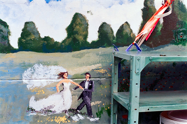
The Flower Box, Bush Hill Park, Enfield, 1994, 94-52-65
A small section of the mural from the previous picture shows a wedding couple striding across the fields.
Shops, London Rd, Morden, Merton, 1994, 94-52-44
A fairly typical suburban shopping street with a Boots, Abbey National, Holland & Barrett and at right ‘A NEW FORCE ON THE HIGH STREET’ which I’ve never heard of. The sun is clearly shining but there are ominous clouds above.
Merton Civic Centre, London Rd, Morden, Merton, 1994, 94-52-46
These buildings are still there on the corner of London Road and Crown Lane close to Morden Underground Station and are still Merton’s Civic Centre.
The Civic centre is in a triangle of land surrounded by busy roads. This view seems now largely unchanged except for the names of the shops.
Morden Court Parade, London Rd, Morden, Merton, 1994, 94-52-34
Morden Court Parade is still there a little to the south on London Road from the Civic Centre and looks in rather better condition now. But sadly those 1930s windows have been replaced by fatter plastic double glazing which although greatly more comfortable for the residents both for keeping warm and reducing traffic noise from busy A24 dual carriageway rather spoil the appearance of the building. There are also some new balconies which fit in fairly well with the building and although it has lost than ‘MORDEN COURT PARADE’ from the frontage it has been replaced rather larger on the roof.
My photographic projects in London relied on being able to get a train from Staines, and although the service was generally rather better back in the 1980s than now, there were still times when I turned up at the station only to find there were no trains running. It was probably on one of these days when I’d arrived at the station with my camera bag on my shoulder that I decided instead of going back home to take a walk around the town instead. There is nothing spectacular about these images, but I think they are an interesting record of a time and place and one that in many respects has changed since I took them in October 1987.
Clarence St, Church St, Staines, Middx, 1987, Spelthorne
This corner has changed relatively little, but Johnson and Clark, the Staines department store said to have been the inspiration for a sitcom closed long ago, and its main building on the other side of the road not in this picture long demolished. It was a business which always seemed stuck in a 1950s time warp. The shop with a closing down sale at right had been Staines first supermarket, a small Tesco , but possibly it was a successor selling up; it is now a Wetherspoons, and the last pub I visited before the lockdown in December.
Market Square, Staines, Middx, 1987, Spelthorne
The Blue Anchor was in business here, possibly from the 15th century, and the brick facade dates from 1721. Some of its windows are real but others only painted, presumably because of the window tax which first came into force in 1696 and was only repealed in 1851, and its hard to see the difference in this picture. One of the major inns in the old town, it closed as a pub around 2006, and has since been a series of restaurants, currently Turkish and of course only able to serve takeaway meals.
Staines Town Hall was built in 1880, financed by public subscription and the building became redundant when Spelthorne Council built new offices around a mile away – and at roughly the same time was Grade II listed. For some years it was used only for occasional concerts (and is the courtroom in the 1982 film Gandhi) but the council spent £1 million to convert it into a much-needed arts centre in Staines which opened in 1994. But this lost money and was closed in 1999 being at the wrong end of the borough to get support from the Tory council. It reopened as a wine bar from 2004-12, then was left empty (apart from a brief squat) before being sold off to a developer for £1.6 million with planning permission granted in 2018 for conversion to flats despite there being no parking space and inadequate disabled access. Many Staines residents regard it as a scandalous loss of what should have been seen as a major public asset for the town desperately short of cultural facilities.
Cock Inn, Church St, Bridge St, Staines, Middx, 1987
The Cock Inn, built in 1832 on a site that had been a pub for several hundred years, closed in 2009 and is now offices. Behind it was Ashby’s Brewery, where a modern building for Courage can be seen peeping over and to the left, but it served Brandon’s Fine Ales, brewed in Putney. Some of the older Ashby buildings still stand, converted to residential and office uses and the Quaker Ashby family was one of the most important in the growth of Staines.
A second Staines brewery, on Kingston Rd, set up by the Harris family was taken over by Ashby’s in 1903 and closed in 1914. Later it briefly became Staines Library and then an adult education centre for Surrey County Council but was closed 15 years ago and has been empty and unused since. Squatters occupied it in 2015 attempting to open up the buildings for community use but were evicted after a couple of months.
Clarence St, Staines, Middx, 1987
Clarence Street was built as the approach road to the new Staines Bridge designed by John and George Rennie and opened by King William IV and Queen Adelaide in 1832, a short distance upstream of previous bridges thought to have crossed the river since Roman times close to the Market Square. It was the fourth bridge to be built since the Civil War and is still in use, widened considerably in 1958, but still a bottleneck. The building on the corner of Bridge St was in the 1970s Staines Library.
High St, Staines, Middx, 1987
Staines High St is still lined by a few buildings of some architectural interest from the Victorian era, along with some rather less exciting 20th century additions, but the big difference is that it is now pedestrianised.
High St, Staines, Middx, 1987
Another view of the north side of the High St, this time looking east towards the ‘Iron Bridge’ which carries the Windsor Line across the road. Almost all of the buildings here have now been demolished, with a large hotel replacing most of them.
London Rd, Staines, Middx, 1987
The main road through Staines, on the line of the Roman Road to the Southwest which became the A30, becomes London Road to the east of the Iron Bridge seen at the left of this picture. Fortunately the opening of the second section of the Staines bypass in the 1960s takes much of the traffic away from the town which had been a notorious bottleneck. Only the shop and pub barely visible here at the side of the bridge remain (though probably not for long), with both the 1950s shops, the 1930s Post Office and the rest all long demolished and now part of a new partly high-rise largely residential development currently nearing completion – and including a new Co-op store.
London Rd, Staines, Middx, 1987
A little further along on London Road and some pleasant 1920s style parades of shops on the north side (with some of a similar age on the south side, which would have been in shadow – so I will have decided to photograph them another day in different lighting.)
London Rd, Staines, Middx, 1987
Surprisingly the Three Tuns and the two shops to the left are still there today, though sadly closed at the moment. As with all pubs we wonder if it will one day reopen, though we hope so, though it isn’t one I frequent. It was listed on this site in 1798 and possibly dates from rather earlier. The large office block is long gone, and development is promised on the site, though when I last looked it was still just earth and rubble.
There are a few more pictures of Staines on page 7 of my album 1987 London Photos, including just a few of the common land and other open spaces around the area on the edge of London – but just inside the M25 which is perhaps its real boundary.
All photographs on this and my other sites, unless otherwise stated, are taken by and copyright of Peter Marshall, and are available for reproduction or can be bought as prints.