Posts Tagged ‘St Andrew’s’

Capital Ring – South Kenton to Hendon

Sunday, August 27th, 2023

Capital Ring – South Kenton to Hendon: Monday 27th August 2018 was August Bank Holiday, which for many years meant if I was in London I was in Notting Hill for the carnival. But I think the last time I went was in 2012, when I went on Children’s Day and then wrote “either I’m getting too old for it, or perhaps carnival is changing, and this year I found it a little difficult. So I went on the Sunday, stayed around three hours and didn’t really want to return for the big day. So I didn’t.

Capital Ring - South Kenton to Hendon
Welsh Harp and West Hendon Waterside

Since then I’ve been out of London in several years and in the others I’ve thought about going to carnival again, but decided instead to go out for a family walk. And in 2018 with my wife we walked the section of the Capital Ring from South Kenton Station to Hendon Station.

Capital Ring - South Kenton to Hendon

The walk itself is only 6.2 miles, but walking to the station at the end and the kind of wanderings that all photographers indulge in it got a little longer. I’m not the kind of walker for whom a walk is a route march from A to B, but rather someone who likes to go where his eyes lead him in search of interesting views and places.

Capital Ring - South Kenton to Hendon

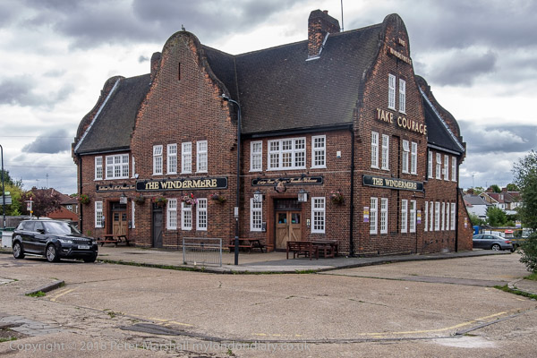
Unlike some sections of the Ring which are almost all woods, fields and trees this one has a wide range of different areas, all of some interest, beginning with South Kenton Station itself, the Windermere pub next door and the whole area of 1930s development.

Capital Ring - South Kenton to Hendon

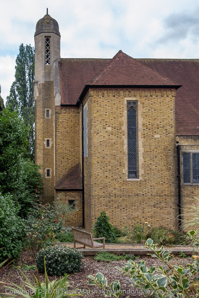
I don’t think my two pictures of The Church of the Ascension really do this interesting 1957 building by J Harold Gibbons justice, but they do give some idea of how unusual it is.

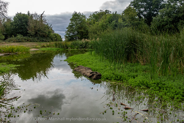
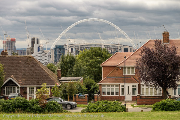
We had the guide to the whole walk around London by Colin Saunders which saves having to carry maps and gives usually clear route descriptions as well as a few snippets of interesting information – such as the fact that this pond on the top of Barn Hill was a part of a huge landscaping project by Humphrey Repton, much of which was covered by housing in the 1920s and 30s and includes Wembley Stadium.

From here we were a little let down by the walk instructions and ended up wandering around a little lost in Fryent Country Park, but eventually with the help of the map and a little guesswork found the correct exit.

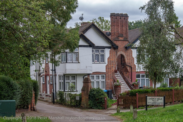
The walk continues through a number of suburban streets, not without some interest, eventually coming to Church Walk. Kingsbury does of course have some remarkable architecture but this lies some distance off the route. Fortunately I’ve photographed it on other occasions.

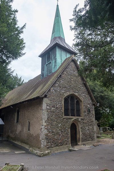
There are two St Andrew’s churches a short distance apart. The ‘new’ church is rather larger and was actually built around six miles away in Wells Street Marylebone in 1844-7 and moved here stone by stone in 1931-3. I haven’t posted a picture of this Grade II* building by S Daukes as it just seemed to me another Victorian gothic church. Probably I would have been more impressed had it been open and I could have seen the interior. A short distance away is the old St Andrew’s, a rather more quaint building with a Grade I listing, dating from the 12th-13th century though with some 19th century restorations.

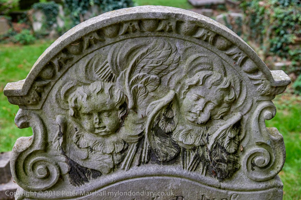
St Andrews Old Churchyard, now left to nature as a ‘Site of Borough Importance for Nature Conservation‘ is also full of interest, with no less than five Grade II listed monuments and tombstones including this one for “Timothy Wetherilt (d.1741). Portland headstone with upper relief of cherubs amid rays, set between auricular scrolls below an upper cornice enriched with egg and dart mouldings.”

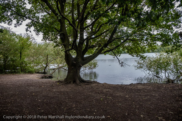
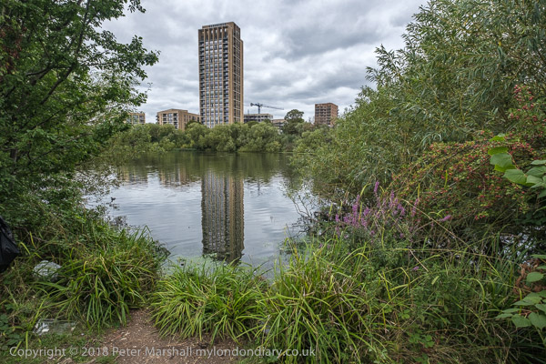
A short walk (with some deviation to a garden centre for its toilets) took us to the Welsh Harp – Brent Reservoir, built in 1835 to supply water for the Regents Canal which had opened in 1820. It got its name from a nearby pub and both pub and lake were for many years a popular leisure destination for Londoners. In 1948 the rowing events for the Olympics were held here, while for 2012 Eton College provided its Dorney Lake, completed in 2006 costing the college £17 million, though we paid through Olympic funding for the finish tower, a new bridge and an upgraded approach road and more.

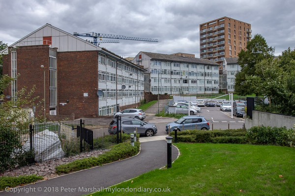
At the east shore of the lake was Barnet Council’s West Hendon Estate, sold off to developers and now West Hendon Waterside. The pleasant and well-loved council estate with 680 homes in decent condition was sold for a quarter of its value to Barratt who describe it as “170 hectares of beautiful green surroundings overlooking the Welsh Harp reservoir” (see top picture.) Some of the council estate was still occupied, overshadowed by new towers with a crane looming over. The development will result in more homes, but few will be social housing, and the so-called affordable properties are beyond reach of the current residents, with many probably bought and left empty by overseas property investors.

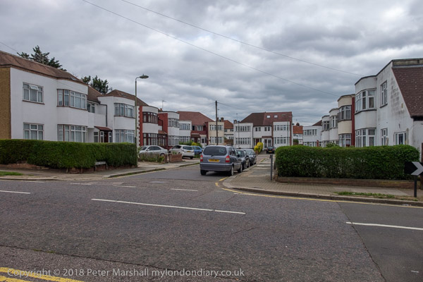
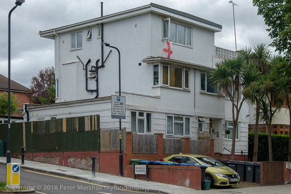
We walked past what was an impressive 1930s cul-de-sac when I photographed it in 1993, but a little less so now as the distinctive metal windows with curved glazing on the bays have been replace by double glazing, though this must make the occupants rather more comfortable.

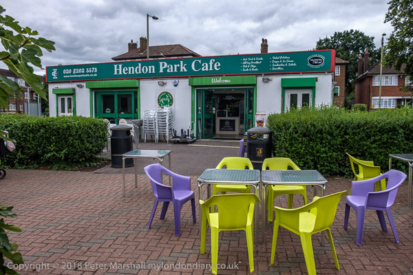
We walked on to Hendon, stopping for an ice-cream at Hendon Park Cafe, “the first kosher park café to open up in the UK” and admiring Hendon Park Holocaust Memorial Garden and the buildings arond Hendon’s Central Circus before catching a train on our way home.

More pictures on My London Diary at Capital Ring: South Kenton to Hendon.


Light & Life, Pinter and Stockwell Breweries

Tuesday, August 22nd, 2023

Light & Life, Pinter and Stockwell Breweries: A week after my previous walk I returned to South London to take more pictures on Sunday 4th June 1989. I began my walk from Clapham High Street.

Landor Rd, Clapham, Lambeth, 1989 89-6b-61

Landor Road, originally named ‘Stockwell Private Road’ but changed at some date before 1912, possibly after the well-known English writer Walter Savage Landor (1775-1864) runs from close to Clapham North Station to Stockwell Green. I made my first picture roughly halfway between the two at the corner with Hubert Grove. A group of five men standing around a car on the opposite side of the road had probably attracted my attention but I clearly did not want to attract theirs.

Many of the shops here have since been converted to residential use.

Light & Life Full Gospel Fellowship, 105-11 Landor Rd, Stockwell, Lambeth, 1989 89-6b-62

A row of four terrace houses here had been converted into the General HQ of the Light & Life Full Gospel Fellowship, and notices gave a full list of activities including Sunday Schools, Divine Worship, Gospel Meeting, Bible Study and Prayer but also Sewing, Cooking, Baking, Musical Rehearsals, Table Tennis , Darts and Snooker. The centre also housed a play group on Monday to Fridays and a Youth Club on Thursday evenings.

A message says ‘COME AND ENJOY YOURSELF – THIS IS NOT A BLACK CHURCH. WE DO NOT PREACH A BLACK GOSPEL – JESUS IS LORD’.

The Fellowship is still continuing its mission there, though with new noticeboards, blinds replacing curtains and a new coat of paint.

Kimberley Rd, Landor Rd, Stockwell, Lambeth, 1989 89-6b-63

I can’t read the notices in the shop window of 127 Landor Road, but I think they might have indicated that the shop had closed. It was perhaps about to be converted to its current residential use.

Looking down Kimberley Road there are two tall blocks of flats, but from my camera position only one is visible, I think Pinter House on Rhodesia Road, one of three blocks in the Grantham Road Estate. 1890s terraced houses there were destroyed by wartime bombing and the site was used for prefabs. Planning for these towers began in the early 1960s under the Metropolitan Borough of Lambeth, but by the time they were completed in 1968-9 they were a part of the London Borough of Lambeth Council.

The three blocks were all named after modern play writers – in this case Harold Pinter. The block was designed by the deputy borough architect George Finch and system built; this 62m high block contains around 92 flats and maisonettes. The flats were refurbished in 2000-2001 after they became managed by Hyde Southbank Homes and now look rather different.

St Andrew's, Church, CofE, Landor Rd, Stockwell, Lambeth, 1989 89-6b-64
St Andrew’s, Church, CofE, Landor Rd, Stockwell, Lambeth, 1989 89-6b-64

St Andrew’s Stockwell Green in Landor Rd was built as a chapel in 1767 but there were later additions and the exterior was rebuilt by H E Roe in this Romanesque style in 1867. Vestries and the Lady Chapel were then added in the 1890s.

The building beyond the church was a large post-war bottle store which was replaced in 2010 by the perhaps deliberately rather bland Oak Square development. This had been a brewery site since 1730 and had been taken over as Hammertons Stockwell Brewery in 1868. It was sold to Watneys in 1951 and they used it as bottling stores.

Two Boys, Landor Rd, Stockwell, Lambeth, 1989 89-6b-65

I find it hard to positively identify this street corner though I think it must be than of Dalyell Road, where Landor Road meets Stockwell Green. The building at left is the now-demolished bottle store, and on it you can read the name THE QUADRANT. The corner is occupied by a giant billboard, and shop appears to have fruit in its window, a sack of potting compost on the ground outside and to sell ice cream.

House, 21, Combermere Rd, Stockwell, Lambeth, 1989 89-6b-66

This is a rather unusual detached house on Combermere Road and I think from my picture that it may have been built or later used as a shop. This is a very mixed street and there was nothing like this anywhere along its length.

It is still there, though the windows have been replaced with something looking rather sturdier and the door has a wrought iron grille.

Stockwell Depot, Combermere Rd, Stockwell, Lambeth, 1989 89-6b-56

Rhodes’ Brewery – Stockwell’s other brewery – took water from an artesian well on this site and was bought by Edward Waltham in 1851. His British Brewery or Half Guinea Ale Brewery in Stockwell Green produced Half Guinea Ale and London Brown Stout at 2/6d per dozen bottles; you paid an extra 6d for the mysteriously named ‘S N’ Stout. It many have stood for ‘Nourishing Stout’, something they also sold as Butler Brand Nourishing Stout.

Back in the 1940s or 50s, my mother, then languishing in hospital, was prescribed a daily bottle of Guinness. As a lifelong total abstainer she refused to drink the demon alcohol, but her Irish nurse had no such qualms.

The buildings probably dated from before 1851. The Lion Brewery bought the company in 1906 and for many years this site was a council depot. It has now been replaced by housing.

To be continued…