It wasn’t of course the last time I went to Wandsworth – I was even back there a couple of weeks ago, walking through the same areas, though much of it now hardly recognisable.
West Hill Primary, School, Broomhill Rd, Wandsworth, 1990, 90-3c-25
The school building is locally listed and its address is 5 Merton Road, but this is the view from Broomhill Road.
London Theatre School, Chapel Yard, Wandsworth, 1990, 90-3c-26
On a second image I made of this building I can just about make out the inscriptions on the frontage as at left ‘Erected 1573, Enlarged 1685 and on the right ‘Repaired 1809 – 31, Rebuilt 1882’. You can read all four plaques lower on the building on the London Remembers site.
This is Wandsworth Chapel and possibly the site was first used by Huguenots, though perhaps only rather later than this. Another plaque lower down mentions a Dutch congregation but from 1713-87 this was the ‘French Church.’ Later from 1809 it was Congregational and a plaque states they continued to use it for mission work until 1939 after moving to a new church on East Hill in 1860. Its history reflects the many immigrants who settled in Wandsworth and set up industries along the Wandle using its water and the power it could generate.
The current building with a hall which could hold 500 people opened in 1883 and is locally listed. Since housing the London Theatre School it became the National Opera Studio.
Pizza Delivery, Scooters, Wandsworth High St, Wandsworth, 1990, 90-3e-65
Pizza Delivery began in the UK in the mid-1980s, but back in 1990 you had to phone for a pizza, with on-line ordering only becoming widespread in the late 1990s. It was still fairly unusual in 1990 and HIPPO PIZZA with this row of five scooters ready and waiting for a call was something of a pioneer.
Entrance, Car Wash, Wandsworth High St, Wandsworth, 1990, 90-3e-66
‘Welcome, Please Drive In’ for a ‘Guaranteed Complete Clean’. At at right someone sits waiting. There is still a ‘HAND CAR WASH’ here on the High Street.
Gas Holder, Armoury Way, Wandsworth, 1990, 90-3e-51
I walked up Ram Street again to Armoury Way and took a few more pictures of the gas holder – which I’ve written more about in earlier posts about this walk.
Gas Holder, Armoury Way, Wandsworth, 1990, 90-3e-53
I think I then looked at my watch and hurried to Wandsworth Town Station taking no more pictures to catch a train rather than have to wait another half hour for the next one.
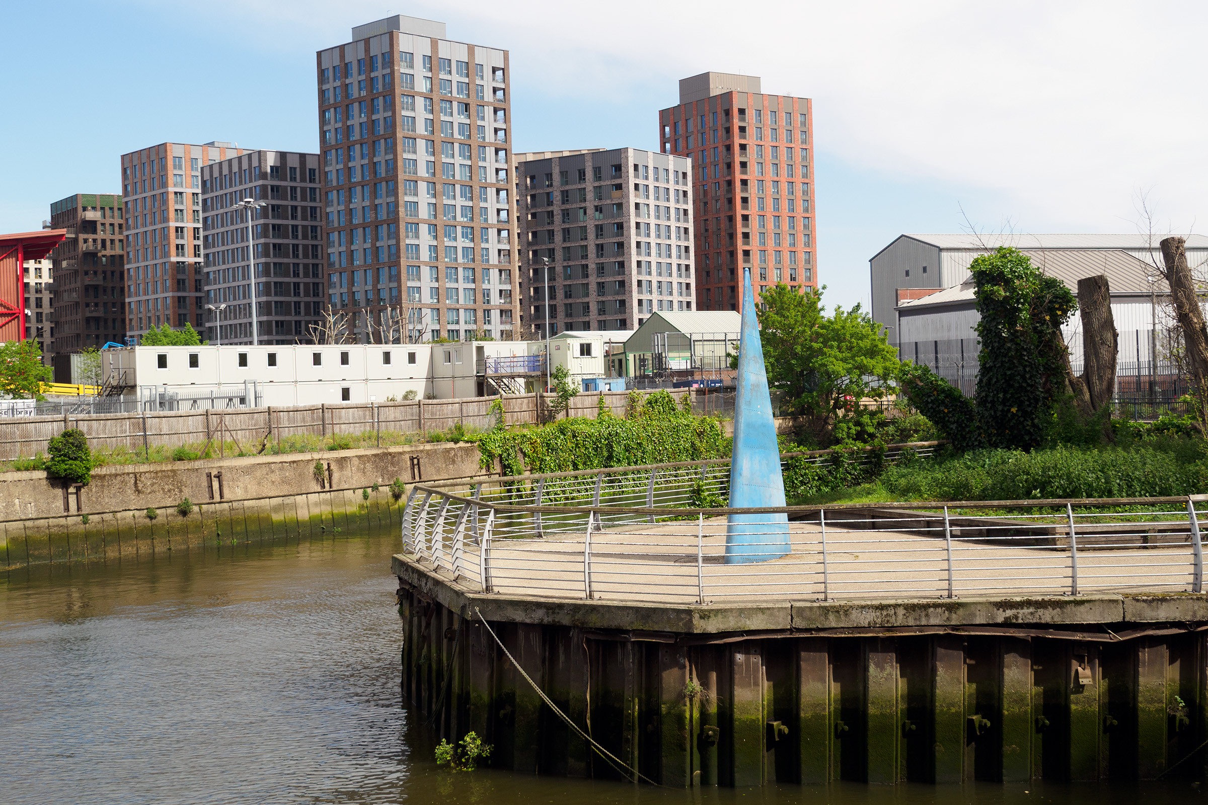
Finally, here is just one picture from the area I made on my last visit in April 2026, looking across where Bell Lane Creek and the River Wandle join. On ‘The Spit’ is a sculpture, ‘Sail’, by Sophie Horton placed there in 2003, financed by the Wandsworth Challenge Partnership. It was inspired by the sail of a dinghy, though I don’t think these have ever sailed up here. But perhaps in the new Wandle Riverside they will.
The flats are part of a new development on the former site of the Wandsworth Gasworks. And where I was standing to take this picture where there is now a riverside path leading to the River Thames was, back in 1990, part of the Shell Oil Terminal.
Clapham Common Northside, Cedars Rd, Clapham, Lambeth, 1989 89-7n-24
This truly grand scale building facing Clapham Common is at the western edge of the London Borough of Lambeth and the road in the foreground is Cedars Road. A terrace of five mansions at 48-52 Clapham Common North side, it was built by J T Knowles in 1860 with the two ends as pavilions with roofs like those of French Renaissance chateaux. It was Grade II listed in 1969 as Knowles Terrace.
Earlier the road had been lined with villas built for rich City merchants in the mid-eighteenth century.
Clapham Common North Side, Wix’s Lane, Clapham, Lambeth, 1989 89-7n-25
Wix’s Lane is the boundary between Lambeth and Wandsworth, although the street sign is from the Borough of Battersea which was became a part of Wandsworth in 1965 and my map shows the boundary as running along this wall.
Charles Wix was a builder and he built a villa for himself on Clapham Common North Side on the west corner of Wix’s Lane around 1780, living there until his death in 1820. Not long after this was rebuilt as Cedars Cottage but it and its neighbours were later replaced by a rather bland red-brick terrace.
The view here gives a better view of the rather heavy ornamental work on the 1860s Knowles Terrace.
The London School Board built Wix’s Lane School, which opened on 27th April 1903. It later became Wix County Primary School. It is now still in use as Belleville Wix Academy and also houses a Lycée Francais.
Wix’s Lane had been a field path from Clapham Common to Lavender Hill but when villas were built along this section of Clapham Common North Side they were given back entrances from it for stabling their horses and carriages. The school was the first building on its west side, taking a large section of the gardens of one of these houses, Byram House.
The Belleville Wix Academy history page includes a quote from a 1937 school inspector ‘”in the early years it was not uncommon to see twenty or thirty children being led to and from Wix’s Lane School by maidservants“. However, it goes on to say: “now the larger houses are divided into flats, and these, as well as the smaller houses in the neighbourhood, are occupied mainly by clerical workers in the City, by local tradesman and shop keepers, and by artisans and labourers of the better type“. “Poverty exists“, it states, “although it is mainly courageously hidden“‘ .
Flats, Cedars Rd, Clapham, Lambeth, 1989 89-7n-12
I walked back to Cedars Road and walked up it past some rather more modern flats on my way to Wandsworth Road. Much of both sides of this tree-lined road are now covered by similar modern flats, and few of the trees are cedars. A few older houses remain but although I photographed a couple of them I’ve not put these pictures on-line.
I turned west on Wandsworth Road and then went up Acanthus Road, on my way to Brassey Square.. Acanthus Road becomes Grayshott Road, and this house is on the corner of that and Glycena Road.
This and a similar house opposite act as a gateway to the Shaftesbury Park Estate built between 1872 and 1877 by the Artizans’, Labourers’, & General Dwellings Company, about which I’ve written in previous posts. These houses and their short terraces are one of only two listed parts of the estate. It was just a little further up the road at what are now Nos 65-7 that Lord Shaftesbury formally began the estate with a memorial stone in 1872. It is still in place but I didn’t photograph it.
I turned east down Sabine Road, another of the first streets to be built after that stone was laid with its message ‘Healthy homes, first condition of social progress’ in 1872. Supposedly the main figure in the 1951 Ealing comedy The Lavender Hill Mob lived in a seedy boarding house here, though none of the film was shot in the area. In just a few yards I was in Brassey Square, intended to be the centre of the estate which is now the Shaftesbury Park Estate Conservation Area.
Brassey Square which took its name from contractor Thomas Brassey and his three sons who all became MPs and had shares and it was meant to have a garden at its centre, but this was built over in 1879. This building with its frontage on Sabine Road has doors numbered 78 and 1 presumably for that road and Brassey Square respectively. The building is locally listed and is presumed to have been a part of the never-completed plan to build a library, central hall and co-operative shops fronting Brassey Square.
My account of the walk will continue in a later post.
Marco Polo House, The Observer, Queenstown Rd, Battersea, Wandsworth, 1989 89-7l-13
One of few interesting postmodern buildings in London, Marco Polo House, designed by architect Ian Pollard for The Observer and British Satellite Broadcasting this was completed in 1989. It was demolished in 2014, probably to prevent it being listed and replaced by the rather anodyne flats now on the site.
Marco Polo House, The Observer, Queenstown Rd, Battersea, Wandsworth, 1989 89-7l-12
Another picture of Marco Polo House with cars parked giving a good impression of the impressive scale. At right is the railway viaduct with a train passing on the line from Victoria Station. This is the southern end of the building with a fairy mature tree newly planted in the foreground; it only briefly survived the demolition of the building.
Marco Polo House, The Observer, Queenstown Rd, Battersea, Wandsworth, 1989 89-7l-14
This giant stone carried the name of the building and I think was at the north end of the building on the corner of Sopwith Way or perhaps a little down that minor side-street. At right you can see a little of Marco Polo House and above it the unmistakable chimneys of Battersea Power Station, with the cranes with which McAlpine had removed the roof in the then recently abandoned scheme to convert it into a theme park.
Chelsea Bridge, River Thames, Battersea, Wandsworth, 1989 89-7m-64
I walked up Queenstown Road to the foot of Chelsea Bridge and went a few yards down the path into Battersea Park to take this picture looking across the Thames to Pimlico.
Although this was the side of an ancient river crossing fordable when the tide was low, the first bridge here was only opened in 1858 to provide access from north of the river to the new Battersea Park opened in the same year. This was a rather narrow and flimsy looking structure was named Victoria Bridge – and at the other end of the park Albert Bridge was built a few years later. Both were originally toll bridges but failed to be a commercial success and were taken over by the Metropolitan Board of Works in 1877 with the tolls being abolished in 1879.
It was renamed Chelsea Bridge when it was found to be structurally unsound to avoid any embarrassment to the Queen should it collapse but it was not until 1926 that a replacement was proposed. In the meantime the old bridge had appeared in many paintings, drawings and photographs, although the bridge that inspired Billy Strayhorn – probably from the painting by Whistler or Turner to name his impressionist composition Chelsea Bridge, was almost certainly of Battersea Bridge. The jazz standard was first recorded by the Ellington orchestra in 1941, after both had been replaced by more modern structures. Somehow I think the tune would have been less successful had it been named Battersea Bridge.
The current bridge opened in 1937 and “was the first self-anchored suspension bridge in Britain, and was built entirely with materials sourced from within the British Empire.” The main cables attach to the end of the bridge deck rather than onto the bank.
Marco Polo House, The Observer, Queenstown Rd, Battersea, Wandsworth, 1989 89-7m-66
I turned around and walked back down Queenstown Road, and could not resist taking more pictures of Marco Polo House from the opposite side of the road.
Towering above it was the giant gasholder and I carefully chose my position to make this into an unlikely addition to the post-modern building. This was the largest and seventh gasholder to be built on the site for the Nine Elms gas works which was further down Nine Elms Lane and was built in 1932 to the innovative designs of the German company Maschinenfabrik Augsburg-Nürnberg and so was the MAN holder. It and the other remaining holders were finally demolished in 2015.
Marco Polo House, The Observer, Queenstown Rd, Battersea, Wandsworth, 1989 89-7m-51
And this was the final picture I took of Marco Polo House on the walk, showing the south end of the building and attaching to it at right two of the Battersea Power Station chimneys.
Convent of Notre Dame, School, Battersea Park Rd, Battersea, Wandsworth, 1989 89-7m-53
I turned back onto Battersea Park Road to make this photograph of the former convent school, with the MAN gasholder appearing on the right edge of the picture. The Sisters of Notre Dame came to Battersea in 1870 to provide Catholic education for the poor children of the area with a public elementary school and also a private day school. In 1901 it reopened as Notre Dame High school for Young Ladies and in 1906 increased in size as it began to admit girls on LCC County Scholarships and a new wing was opened in 1907. Until 1919 there were some dormitories for boarders which were then converted to more classrooms and a library.
The grammar school expanded further after the Second World War and became a comprehensive in 1972, closing in 1982 when the building was sold. It was later converted into flats as The Cloisters.
From Longfield Hall I wandered up Knatchbull Road to Cormont Road, which runs halfway around Myatt’s Fields Park on its southwest and northwest sides. I took half a dozen pictures which I haven’t digitised before coming to this on the corner of Brief Street which I think was built as flats. Almost all the buildings in the area are fine examples of late Victorian housing, largely in the Queen Anne style but there is perhaps a slightly overpowering amount of red brick directly onto the streets.
Another finely designed large block of flats a few yards down Brief Street, Burton House, its hedges a few years ago more tidily trimmed but now again reverting to wild. On the opposite side of the street is a short terrace of two storey houses with brief front gardens and Brief Street is appropriately short – a little under a hundred yards in length.
According to Lambeth’s 2018 Character Appraisal for the Minet Conservation Area, “Kennington Boys’ High School (latterly known as Charles Edward Brooke School), Cormont Road opened in 1897.” This was a LCC board school and the Grade II listing states that this building dates from 1912, architect T J Bailey. It is listed on Historic England’s Heritage At Risk Register.
Confusingly – and I hope I have got this right – the school renamed itself Saint Gabriel’s College when it became co-educational as a Specialist Arts and Music College in 2012, and then moved out to Langton Road a few years later.
Again from the Lambeth appraisal, “The former St. Gabriel’s College on Cormont Road opened in 1899 as a training college for Anglican schoolmistresses, the vision of Charles Edward Brooke, a senior curate of nearby St. John the Divine church; the attached chapel was added in 1903.” The style is described as “vaguely Art Nouveau“. In 1989 it was Myatts House, run by the ATC Group of Training Companies and offering courses in Accountancy, Finance, Management and I think Computers, though the final word on the sign is hard to read. Grade II listed.
The building was requisitioned in the First World War, becoming part of the 1st London General Hospital, and was where Vera Brittain was first stationed. Later it became a LCC rest Home. It is now residential, converted to expensive flats as St Gabriel’s Manor.
This is Calais Gate, also Grade II listed and said in the listing to date from the early 20th Century, though the Myatt’s Park history site dates that these large mansion blocks as c. 1895.
Perched on top of the fine stepped gable is a terracotta cat, one of a number of cats on buildings on the Minet estate, though most are rather less prominent. The whole estate was developed by the Minet family who were of French Huguenot origin, and their name is an affectionate or childish French term for a cat, (minette if the cat happens to be female.)
Houses, Calais St, Myatts Fields, Camberwell, Lambeth, 1989 89-4j-22
Substantial houses in Calais St facing the park on the north-east side. I wondered when I took this on the significance of the gateway at left with the cross above, but am no wiser now. Hard to make out from this picture but those are cats heads above the doorway.
Fine railings and decorative elements on these houses at 22 and 24 Flodden Road make them stand out and the absence of cats perhaps suggests these large semidetached Queen Anne style houses were not a part of the Minet development. Instead there are leaves and floral motifs and human heads.
Flodden was the site of a battle in 1513 in Northumberland, close to the border with Scotland when the English Army soundly defeated the army of King James IV of Scotland. England were engaged in a war with France and the Scottish invasion was in support of the ‘Auld Alliance’ they had made with France in 1295.
It was time for me to leave the area, and I walked up Flodden Road to Camberwell New Road to get a bus, coming out almost immediately opposite Calvary Temple of the United Pentecostal Church a few yards to the north of the road in Councillor St.
The church incorporates a memorial stone “laid by William Appleton Esq (Sutton), June 2nd !890″ with the text “Hitherto Hath the Lord Helped Us” (1 Samuel 7:12), naming George Baines Architect and H L Holloway Builder. The church, then Clarendon Chapel, opened as a Baptist church in March 1891, replacing an earlier ‘tin tabernacle’ which had burnt down in 1889. Clarendon Street became Councillor Street some time before 1912 and the church was renamed Camberwell New Road Church, continuing in use for Baptist worship until the 1950s.
It narrowly escaped demolition in 1959 when it was saved by Caribbean immigrants who were looking for a building for their Pentecostal worship and they held their first service there in March 1959. They kept and restored the churches original late Victorian fittings and it remains in use.
Then and now it makes a dramatic composition with the tower block behind, Laird House on Redcar St, one of five 22-storey 210ft blocks on the 1966 LCC Wyndham & Comber Estates.
New Road Bargains, Camberwell New Road, Lambeth, 1989 89-4j-12
There are few if any shops in Myatt’s Fields but several parades within walking distance including on Camberwell New Road where at 243 was New Road Bargains with a small chair fixed above its door and a wonderfully packed window of assorted items. For some years this has been Camberwell Daily, now with a shop front that offers GROCERIES | FRUIT & VEG | OFF LICENCE | NEWS & MAGS.
I might have photographed other shops in the row, but my bus came and I got on it to begin my journey home.
Stoke Newington or ‘Stokey’ has a well-deserved reputation for non-conformity of all kinds. The area from the middle-ages attracted many religious dissenters, Quakers and other non-comformists. Among them have been Isaac Watts, Daniel Defoe, John Howard, Edgar Allan Poe and Joseph Conrad. More recent years have seen many squatters, artists and bohemians, as well as political radicals, including Angy Brigade and IRA bombers. You can see a long list on Wikipedia. Although its now become rather gentrified, at least in parts, there are still signs of its more anarchic past. Parts of the area I walked around in the south weren’t even in the area until 1900, but were ‘Hornsey Detached’ – and Hornsey is several miles to the northwest.
School, Smith & Sons, Wordsworth Rd, Hackney, 1988 88-10a-42
St Matthais C of E Primary is still in use at the rear of Smith & Sons at 22-32 Matthias Rd, N16, Ironmongers & Builders Merchants. This writing has now gone, but the building was still there and in a similar use as one of the more Travis Perkins showrooms until around 2019.
The Coach and Horses was in business here at least since the 1850s and in one early record the street was called Coach and Horse Lane. I’m not sure when it got the New in its name, perhaps after it stopped being a Reid & Co pub and serving their ‘Entire’. The company was founded to take over a brewery in Clerkenwell in 1757 by Richard Meux and Mungo Murray and only picked up Andrew Reid as a partner in 1793, becoming Reid& Co in 1816. They stopped brewing in 1899 after becoming a part of Watney, Combe, Reid & Co. Ltd in the first big merger in the UK brewing industry, but Watney continued for years to use the brand name for some beers.
At a glance the pub appears open, but the two long brackets without pub signs are presumably a sign that it had closed. Shortly after it was converted into flats.
Milton Grove, Stoke Newington, Hackney, Islington, 1988 88-10a-32
I took a couple of pictures at Newington Green (not online) before being attracted up the narrow passage of Church Walk and through the footpath to Howard Road and then taking Milton Grove, home of five times world professional darts champion Steve Bristow who lived at 97.
I don’t know of any particular link with Milton and Stoke Newington but when these streets but when the National Freehold Land Society laid out the streets in the area in 1852 they created Milton Grove along with Shakespeare Walk and Spenser Grove. Much of the area was destroyed in the war and rebuilt as the Milton Gardens Estate. And behind me as I took this picture was an open space, once a bomb site but kept as Butterfield Green. Bombs came into Milton Groves story again some years later in 1975, when an IRA bomb factory was discovered in a top floor flat at no 99.
A little to the south is an alley, Town Hall Approach, but you will find no sign of a town hall should you walk down it. This was the site of the Italianate South Hornsey Town Hall built by E Fry in 1881 which became the town hall of the Metropolitan Borough of Stoke Newington when this was created in 1900. Stoke Newington was only half the required size for a London borough, but the authorities granted it borough status to avoid “intolerable and interminable feuds” had it been subsumed into Hackney – which it eventually became part of, apparently without a revolution in 1965. But the old town hall was too small and after 37 years the borough opened a new one designed by John Reginald Truelove on Church Street – now a listed building – but the ‘approach’ is still there.
I wondered why No 72 was built with this large window and imposing door – perhaps it was a former chapel long converted to residential use. A few doors down, just visible over the cab of this recovery vehicle is the only listed building in the street, No 66, described (in part) as “Mid C19 villa of 2 storeys and basement, 3 windows. Stock brick….” Certainly a pleasant enough house but nothing in the text seems to justify the listing or greatly differentiate it from others in the area.
It was quite a long walk before I made my next exposure at 29 Neville Road, once home to G Howell Upholsterer, but in 1988 flyposted against the Poll Tax. Something about the doorway at right of this image screams “Pub!”, and this was then The Nevill or The Nevil Arms.
Once specialising in Smith, Garrett’s Special Mild Ale, it had a moment of fame in May 1915 when a bomb dropped in its back garden during London’s first Zeppelin raid. A large incendiary bomb, it failed to ignite and did no damage. It was thought at one time to have been the first bomb dropped on London, but that fell a short distance away in Alkham Road. The pub was on this site since the 1870s and latterly a Charrington’s pub. I think it closed shortly after I made this picture and was converted to residential use around 2000.
A photograph after the raid shows that No 21 on the other side of the shop was quite badly damaged, certainly its windows blown out, while the shop, then selling confectionary and advertising local Clarnico along with Rowntrees Chocolates and (I think) R Whites Ginger Beer appears undamaged with a woman looking out of the second floor window as the crowd gawping at the damage next door.
Stoke Newington Rd, Hackney, 1988 88-10a-34
This and the picture below were from a window of the same shop, protected by a strong wire grill. And while I may have known more when I took them, they are now a mystery to me.
What is on sale here? Is it wigs? The strange prints are part of a collection and have reference numbers at the lower left, but what collection? The name appears to start BI or even BII and end IERTON but the wire prevents me seeing the letters between and I can find nothing which fits between to make sense to me.
Stoke Newington Rd, Hackney, 1988 88-10a-35
The second picture simply adds more confusion. Are these wigs or examples of hair styles or some curious sculptural art? I was always attracted by representations of the human form or face and photographed the window of many hairdressers and some shops selling wigs, but these just don’t seem to fit the pattern.
The fine 1903 Stoke Newington Estate by the Four Per Cent Industrial Dwellings Company in Coronation Avenue and Imperial Avenue (and still run by the IDS) was the site of one of the greatest civilian tragedies of the London blitz, when on 13th October 1940 it received a direct hit from a high-explosive bomb, probably a parachute mine. The Coronation Avenue block of the estate collapsed into the large communal air-raid shelter in its basement; many were killed directly while others were unable to make their escape as the cellar flooded with water. At least 160 people are thought to have died.
The Apollo Picture House opened in 1913, becoming the Ambassador Cinema in 1933 and in 1966 became a bingo hall but was reopened as the Astra Cinema in 1974. It was soon converted into a cinema club showing martial arts and softcore sex films until it closed in 1983. It was then converted into a Turkish mosque, with its interior features being gutted and its exterior covered in highly coloured mozaic. The cinema had already had a Moorish look with the two domes at each end of the facade.
Poplar To Limehouse 1988 – my walk continued on the East India Dock Road.
East India Dock Rd, Poplar, Tower Hamlets, 1988 88-7q-51
From the posters in the window this was clearly a video rental store, a relatively new thing back in 1988 – the first Blockbuster Video store only opened in Dallas, Texas in 1985. Home video recording only began to be popular after the introduction of Betamax in 1975, followed in 1977 by VHS (along with other formats.) By 1988 VHS had become the dominant format.
But my attention was caught by the notice on the door, ‘NO DOGS OR BIKES ALLOWED’ with a very small ‘Thankyou’ and the two bikes (I think a BMX and a racer) flung down on the pavement outside unlocked by their two young owners.
Poplar Labour Party, East India Dock Rd, Poplar, Tower Hamlets, 1988 88-7q-53
Poplar Labour Party, led by George Lansbury, gained control of Poplar Borough Council in 1919. Poplar was one of the poorest areas of the country and so rateable values there were low. With councils then being responsible for supporting the unemployed and poor, council rates thus had to be set at a much higher level than in wealthy boroughs, which was clearly unfair on boroughs like Poplar who had so many more people needing support. Their rates were the highest in London, twice as high as in the wealthy borough of Kensington.
Poplar Labour had come into office to make changes, to provide greater support for the poor, to set a higher minimum wage for council workers and to pay women equally to men. When a demand from government came in 1921 to increase contributions for cross-London authorities Poplar council refused to pay, instead voting to use the money for the local poor. The authorities took them to court, and 30 councillors marched there with two thousand supporters. All of the councillors were sentenced to prison, where one of the six women, Minnie Lansbury, died, only 32.
Public outcry with large demonstrations and some riots – and other councils following Poplar’s lead – led to the councillors being released with an Act being rushed through Parliament to make the system more fair, with richer boroughs contributing more and the poorer less.
Their protest had clearly been illegal, but was clearly justified, and it led to a much-needed reform. It’s a lesson which still has relevance, particularly with such current matters as statues and the Government’s Police, Crime, Sentencing and Courts Bill.
Richard Green, statue, Poplar Baths, East India Dock Rd, Poplar, Tower Hamlets, 1988 88-7q-54
The statue of Richard Green still stands outside Poplar Baths, a Grade II listed building from 1933, replacing an earlier baths from 1852. The baths were largely to provide washing facilities when few homes had bathrooms in this poor area of the city. As well as ‘slipper baths’ there were also vapour baths, showers and laundry facilities. The new baths in 1933 was a huge building including these facilities and two swimming pools, the larger of which could be covered over and used as a dance hall, theatre and sports hall.
The baths reopened in 1947 after the war despite considerable damage and was closed and converted into a training centre in 1988. My picture from 1988 shows a board advertising the support of the London Docklands Development Corporation in providing disabled access.
The building later became derelict but after a strong local and national campaign for its restoration work began on its redevelopment in 2014 and it reopened again as Poplar Baths Leisure Centre and Gym, along with 100 new homes, in 2016.
Richard Green (1803-63) was a local shipowner, shipbuilder and philanthropist, supporting a Sailors’ Home, schools, an orphanage and hospitals in the area, some of which had been founded by his father, George Green. His Blackwall Yard built many ships for the East India Company and for trade with Australia and China. His company, R & H Green in 1919 joined with Silley Weir as R. and H. Green and Silley Weir, with large premises at the Royal Albert dry docks and others and continued in business until sold to become a part of the government owned River Thames Shipbuilders in 1977.
George Green School, East India Dock Rd, Sturry St, Poplar, Tower Hamlets, 1988 88-7q-43
George Green (1767-1849) was the father of Richard Green whose statue with his dog still sits outside Poplar Baths. George married the boss’s daughter and made the reputation of the Blackwall Shipbuilding Yard, building many whalers.
As well as this school dating from 1828 on the East India Dock Road the older Green also endowed schools in Chrisp Street and Bow Lane. The current huilding from 1883 is part of Tower Hamlets College. George Green School in new buildings on Manchester Road became the secondary school for the Isle of Dogs with its first comprehensive intake in 1975.
The War memorial to the children of Upper North Street School is https://britishlistedbuildings.co.uk/101065215-war-memorial-to-the-children-of-upper-north-street-school-poplar-ward Grade II* listed and includes the inscription: ‘IN MEMORY OF/ 18 CHILDREN/ WHO WERE KILLED/ BY A BOMB/ DROPPED FROM A/ GERMAN AEROPLANE/ UPON THE L.C.C./ SCHOOL UPPER/ NORTH STREET/ POPLAR ON THE/ 13TH OF JUNE 1917./ ALFRED H. WARREN O.B.E./ MAYOR/ J. BUTEUX SKEGGS,/ TOWN CLERK. ‘
There is a fuller story at the link above about the first mass German raid on London by Gotha bombers on 13 June 1917 which killed 162, including these 18 children mainly aged 5 or 6. At least 37 other children at the school were among the 432 injured by the raid.
St Mathias, church, Woodstock Terrace, Poplar, Tower Hamlets, 1988 88-7q-45
St Mathias Church is also Grade II* listed, with a number of Grade II listed monuments. Poplar’s oldest church, it was built in 1766 as the Chapel of the East India Company, and became St Mathias as a parish church in 1866. You can see the company’s arms in the roof, and allegedly its columns came from wrecks of the Spanish Armada.
The exterior of the church was altered and enlarged by Teulon in 1875. The church closed in 1976 and was restored for community use by the LDDC in 1990.
Built in 1902–3 as an officers’ annexe to the Scandinavian Sailors’ Temperance Home, founded by Swedish Free Church missionary Agnes Hedenstrom (1849–1928) who began her mission in the East End in the 1870s, opening the home here in 1888. The mission was taken over by the Salvation Army in 1930.
This was I think the last picture I took on my way to Westferry station where I returned a couple of days later for another walk – and the subject of a later post.
Click on any image to see a larger version in my album 1988 London Photos from where you can browse other images.
From Whitecross St I wandered across Old St into Helmet Row to make this picture, before going back across the road.
Old St, St Lukes, Islington, 1988 88-5n-42
Helmet Row is the street beside this building, at at right is the tall spire of St Luke Old St, a Grade I listed chruch designed by John James and Nicholas Hawksmoor, the latter thought to be responisble for the unusual obelisk spire. In 1988 the church was derelict and roofless. Opened in 1733 it became redundant and closed in 1959, remaining empty until taken over as a music centre operated by the London Symphony Orchestra in 2003.
Golden Lane, Baltic St, Finsbury, Islington, 1988 88-5n-43
I don’t think I went out of my way to photograph buildings with street signs on them, but it was very useful when they did have one – or even two like this on the corner of Golden Lane and Baltic St. Both buildings are still there, although only that at the right of my picture is still Mencap. That at left has gained the name LONDON HOUSE written rather large on both sides.
Whitbread’s huge stables, built in 1897 are a reminder of a past age, one that was soon to come to an end, when traffic in London was all horse-drawn, and large numbers of horses were needed to convey barrels of beer to thirsty Londoners. This stables was built to replace a smaller stables on Chiswell street and ramps at the rear enabled horses to be kept on its three floors. The top floor originally had windows like those below, but these were bricked up when it was later used by a gun club as a firing range. Some have now been unbricked.
These stables could house around a hundred horses to pull the brewery drays, a small fraction of the many thousands of horses on London’s streets every day – with a transport system of hansom cabs and horse buses needing around 50,000 to keep running and many more in harness behind various carts and wagons, along with a few saddle horses. And with Shire horses weighing around a ton a piece the stables had to be very sturdy and the pollution problem with each producing between 15 and 35 pounds of manure per day was huge, leading to the Great Horse Manure Crisis of 1894. No solution could then be found to the problem, and it was only the internal combustion engine that eventually came to the rescue – its pollution, though toxic was largely gaseous.
School Caretakers, house, Baltic St, Finsbury, Islington, 1988 88-5n-46
The School Caretakers House and entrance to the Cookery School are still there in Baltic Street, though the school, built for boys, girls and infants by the London School Board in th 1880s, is now the Golden Lane Annexe of the London College of Fashion, part of UAL, the University of the Arts London.
Crescent Row, Finsbury, Islington, 1988 88-5n-31
The corner of Crescent Row and Sycamore St still looks much the same. Plans to demolish the building on the left edge of the picture were approved in 2017, but it appeared to have been renovated a year or so later.
Dress forms, Old St, Finsbury, Islington, 88-5n-34
The view through a window in Old Street. I think this later became a café bar.
More from around Old St in a later post. Click on any of the images to view a larger version in my album 1988 London Photos from where you can browse the album.
The Boltons, South Kensington, Kensington & Chelsea, 1988 88-4o-52
If the houses around The Boltons are all much the same – the Grade II listing text for most simply tells you to see that for the first pair, 1 &2 – some distinguished themselves by their gates. Those of No 16 have lost their eagles since I made this picture, and the iron gates have lost both their angled top and the arch above as well as the rampant creeper but have gained an entryphone and a letter box. Walking down the street today there would be no picture to make here.
The Boltons, South Kensington, Kensington & Chelsea, 1988 88-4o-66
There are various designs of wrought iron gates to the houses around The Boltons, though quite a few share the same pattern. This one, I think at No 23, appealed to me more than most and I was fortunate to find it half opened, giving a clearer view of the tiled path and those ornamental ceramic leaves containing a small bush.
It also shows the peeling paint which still then could be seen on quite a few of these houses, which are now all I think pristine. I rather liked the impression it gave of these houses being old and lived in.
Boltons Place leads north from The Boltons to the Old Brompton Road and its east side is occupied by several large houses. That occupied by Jenny Lind, the ‘Swedish Nightingale’, has undergone various changes of street name and number since she moved in as the first occupier in 1874, and is in a rather different style to the rest of the area. In 1906 it was altered by the addition of a rather attractive semi-cicular bow window, hidden in my view. The effect is less austere, described in the Victoria History as “un-Godwinian suavity in a rather French way“.
School, Boltons Place, South Kensington, Kensington & Chelsea, 1988 88-4o-54
The west side of Boltons Place is quite different, occupied by Bousfield Primary School. This primary school was built in 1954-6 by Chamberlin, Powell and Bon and is on the site of Beatrix Potter’s house and garden at 2 Bolton Gardens, where she lived for more than 40 years until she was married in 1913, a short walk from Brompton Cemetery where she found some of the names for her characters. The site became available thanks to wartime bombing.
The school is a heavily over-subscribed local authority school which had its origins in a school set up as a “poor school” for local Catholic children by the parish priest in the 1800s which was renamed Bousfield School in 1913. The children were transferred to the new school in 1956. Later the old building became another Catholic school.
The Fulham Road has a rather different atmosphere with this row of shops with an entrance probably for horses to be led through to stables behind. When I took the picture it led to the Hungry Horse Restaurant, and although the board with its two horses heads looks like that of a French horse butcher, the English menu will almost certainly not have included horsemeat – nor will it have had hay offer, so any horses would have remained hungry.
Now the gate seems closed and the area behind looks unused. Unsurprisingly the shop at left is now an estate agent.
The cinema opened as the Forum Theatre in 1930, designed by architect J Stanley Beard, featuring live variety shows with an orchestra. It was sold to Associated British Cinemas (ABC) in 1935 and lost its organ in the 1960s. Like others it got altered internally to provide first three then four, five when I made this picture and finally six screens. Now owned by Cineworld who have transferred it to their Picturehouse chain, it had further renovations in 2019.
All photographs on this and my other sites, unless otherwise stated, are taken by and copyright of Peter Marshall, and are available for reproduction or can be bought as prints.
Thomas Tenison (1636- 1715) was Archbishop of Canterbury from 1694 until his death. Archibishop Tenison School, Lambeth High St, and according to Wikipedia founded boys schools in Lambeth in 1685 and Croydon in 1714. A school for 12 girls began in Lambeth in 1706, and this was built as a new girls’ school in 1863. In 1961 the school amalgamated with a nearby Church of England boys school and this building went out of use, though it was later used as an annexe to the combined school until this closed in 1974. It has since been demolished and replaced by a hostel.
Bennett House in Page St, Wesminster is a Grade II listed tenement courtyard block of flats built in 1928-30. It was a part of the Westminster Housing Scheme for the Grosvenor Estate and Sir Edwin Lutyens acted as consultant; the listing text calls it “An imaginative Lutyens treatment of a standard LCC type of housing block.”
I admired the stark simplicity of the Unemployment Benefit Office on Chadwick St, Westminster. It remained in use – with changes in name – closing as a Job Centre Plus in 2017.
New office buildings seen from Old Pye Street in 1987. Parts of this still remain though rather more difficult to see.
The building on this corner still has the foundation stone laid by James S Burroughes in 1893, though it has moved a few yards around the corner and I think the site is now occupied by “modern purpose-built flats for single people and couples set in a city centre location” built by SAHA, the Salvation Army Housing Association and allocated through Westminster Borough Council’s housing register.
Avocet House at 92-96 Vauxhall Bridge Road was the home of Avo Ltd, a company founded by Post Office engineer Donald Macadie who was fed up with having to carry separate meters for different measurements and in 1923 designed a meter than would measure Amperes, Volts and Ohms. The Avometer was the leading electical test equipment for many years. The company became too large for this site and bought land for a new factory at Dover in 1962. The company is now called Megger, and its testers are still made and in use around the world.
This 1865 Grade II listed building in a free version of Italian Renaissance style by H A Darbishire was an orphanage for children of Crimean War guardsmen. Later it became a Franciscan friary, and they added the statue of St Francis just visible at the far corner around 1960. When they moved on it became offices. Close to Westminster Cathedral, in 2017 it was bought by the cash-strapped Roman Catholic Diocese of Westminster to be refurbished as a pre-prep for Westminster Cathedral Choir School, at a cost thought to be around £10million. The school is said to be the most expensive prep school in London, and sends pupils on to public schools including Eton and Winchester.
I don’t know which shop this was in Upper Tachbrook Street, but it appeared to be selling clothing, jewellery and similar items. From the few details of the shop front which can be seen it looks rather like that now occupied by ‘Mr CAD – For Everything Photographic’. This began around 1960 in Croydon, and although it at one time had nine branches at various sites from Colindale in north London to Brighton became just a giant Aladdin’s cave in Windmill Rd full of secondhand gear, moving to these rather smaller premises in Pimlico but also supplying mail order around the world as “the largest independent photographic dealer in the UKW with “the biggest stock of used analogue photographic equipment worldwide specialising in film, cameras, lenses, enlargers, chemicals, paper, all manner of studio & darkroom hardware & software.”
Clicking on any of the images above will take you to my Flickr album of over 750 images of London in 1987 selected from several thousand exposures I made that year
All photographs on this and my other sites, unless otherwise stated, are taken by and copyright of Peter Marshall, and are available for reproduction or can be bought as prints.
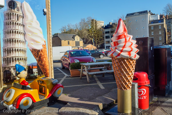
I suppose this isn’t everybody’s idea of a picture of Windsor Castle, but it does rather amuse me, and I was rather brought up with Noddy, who I now realise was at times terribly racist. Noddy was created by Enid Blyton when I was only four, and her last book about him was published in the year I went to university, though since then he has been kept more or less alive on TV and through what is still a best-selling franchise. Mr Golly, who serviced Noddy’s little car seems to have disappeared in the 1990s, and the Gollies who stole Noddy’s car and the song book strongly featuring the n-word are no longer mentioned. It was in the mid 1960s that the racist, classist and xenophobic nature of her books first came under attack. And Windsor Castle is a little less prominent than that Pisan tower.
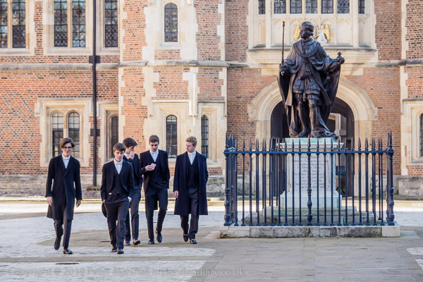
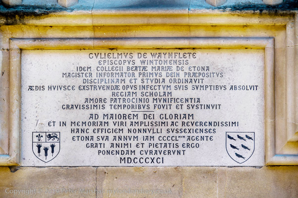
Eton is of course at the very heart of our English class system, and was appropriated by the wealthy from the school founded by Guliemus De Wayneflete for the education of poor boys – as the plaque records.
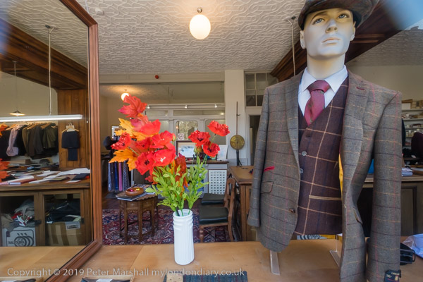
Much of Eton revolves around the school, and perhaps the most obvious signs of that, other than the school buildings themselves are the tailors shops, though it’s hard to imagine anyone actually buying anything in them.
Eton is a ridiculously wealthy and privileged place, though the school does offer some scholarships to gifted poor children, and we were once encouraged by his primary headmaster to put our elder son forward for one. I don’t think he would have survived, either the preparatory school that scholarship boys start at to repair some of the ravages of the state system and certainly not the school itself.
As you walk back towards Windsor, sanity does start to return and there is at least one decent pub where we lunched before returning over the pedestrianised bridge to Windsor, itself a curious place under the shadow of royalty and the military, and also a town full of tourists.
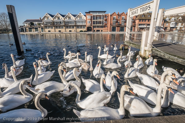
The swans were massing where tourists feed them, across the Thames from the Eton College boat house. I walked to the bus stop to return to the real world.
There are no adverts on this site and it receives no sponsorship, and I like to keep it that way. But it does take a considerable amount of my time and thought, and if you enjoy reading it, please share on social media. And small donations via Paypal – perhaps the cost of a beer – would be appreciated.
All photographs on this and my other sites, unless otherwise stated, are taken by and copyright of Peter Marshall, and are available for reproduction or can be bought as prints.