Posts Tagged ‘Queens Dock’

More River Hull, Lime St and Wincolmlee 1989

Monday, March 25th, 2024

More River Hull, Lime St and Wincolmlee – pictures made in August 1989

Clarence Mill, Drypool Bridge, Dry Dock, River Hull, Hull, 1989 89-8f-61

Looking across the River Hull from the riverside path through the scrap metal you can see the Drypool Bridge and the converted warehouses on Clarence Street between High St and the River. Further to the right are the gates of a dry dock and I think the chimneys of Blaydes House, now the University of Hull Maritime History Institute at I High St.

Dry Dock, River Hull, Hull, 1989 89-8f-62

Swinging around a little brings a second set of dock gates into view, and this was the entrance to Hull’s first inland dock, needed as the Old Harbour on the river bank was getting far too congested. The Hull Dock company, founded in 1783 and the first of its kind, built the dock and opened it in 1788 simply as the Dock. It was built close to the site of Hull’s medieval walls and the street just to the south of the former dock is still called North Walls. The dock was renamed Queen’s Dock when Victoria visited in 1854 and all but the short section between the river and Dock Office Row was filled in in the 1930s and reopened as Queens Gardens in 1935.

Dry Docks, Hull College, River Hull, Hull, 1989 89-8f-63

The Yorkshire Dry Dock Co Ltd, Ship Builders Ship Repairers were incorporated in 1917, but there had been dry docks here much earlier as a detailed study in Paul Gibson’s Hull and East Yorkshire History relates. Hull’s Arctic Corsair, currently being restored, is expected to open to visitors at North End Shipyard in early 2025.

Works, Lime St, Hull, 1989 89-8f-54

Lime street runs parallel with the River Hull on its east side from North Bridge to Scott Street Bridge, and then on to the busy industrial Cleveland Street, always in the 1980s one of Hull’s dustiest streets. Between Lime Street and the river were a number of wharves and many were still in use in 1989, and some businesses here still had some maritime connection.

This picture is looking south down Lime Street from its junction with Jenning Street. I turned into Jenning Street. There are some bulk storage tanks and timber storing sheds in the middle distance and three large of cranes suggesting some large redevelopment.

Scott St Bridge, Hull, 1989

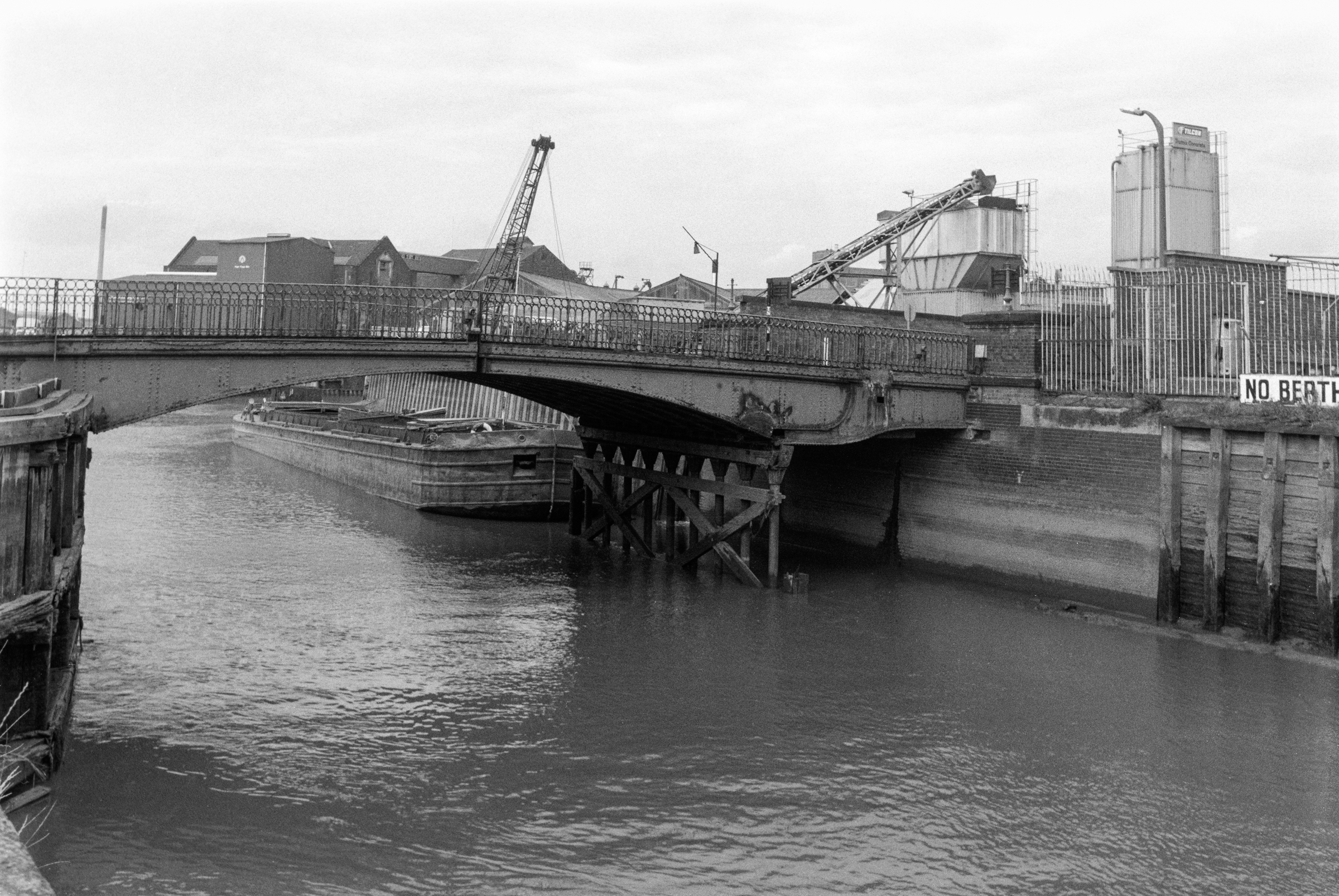
Back in 1989 I was still able to cross the river on Scott Street Bridge. I think Hull Council had long wanted to close this Grade II listed hydraulic double leaf bascule bridge and had deliberately failed to maintain it, allowing salt water to corrode its mechanism. Finally in 1994 they pronounced it unsafe.

It hit the national headlines in January 2018, when Banksy came to to Hull and drew a figure of a young boy brandishing a pencil for a sword called “Draw the Raised Bridge”. The council removed the Banksy in October 2019 and then demolished the bridge completely. Some noises were made by the council about replacing it with a replica, but don’t hold your breath.

Pauls Agriculture Ltd, Wincolmlee, Hull, 1989 89-8f-42

A man cycles down the Scott Street Bridge approach with its warning lights for bridge openind. On the other side of the long railing is Wincolmlee, the street which follows the River Hull on its west side.Two Buildings belonging to Pauls Agriculture Ltd are linked across the street by a bridge.

Pauls Agriculture was founded in Ipswich in the early 19th century initially as traders in malt and barley, but by the twentieth century there main business as in maize, which they crushed to produce vegetable oils for soap and other industrial uses with the remaining oil cake being used to produce animal feeds. In 1992 they merged with BOCM.

Much of the maize was imported, from the USA and elsewhere, so a riverside site made sense. But when transport by road took over it made more sense to site crushing mills in agricultural areas.

More to follow from Hull in August 1989 – and there are more pictures on Flickr in both black and white and colour.


FlickrFacebookMy London DiaryHull PhotosLea ValleyParis
London’s Industrial HeritageLondon Photos

All photographs on this page are copyright © Peter Marshall.
Contact me to buy prints or licence to reproduce.


Hull Colour 2

Friday, July 10th, 2020

A look at a few more of my colour pictures from Hull in the 1970s.

Paint, Hull 70shull077
Paint, Hull 1970s

I made a number of exposures of this wall, which I think was possibly at one of the dry docks on Dock Office Row, though my memory may be at fault. I often walked up High St from Clarence St next to Drypool Bridge and then on to Wincolmlee, sometimes continuing on up to Bankside or Air St, where I could walk west and across towards my parents-in-law’s house just off Chanterlands Ave north.

I was attracted by the colour but also by the mix of the accidental and deliberate in the markings on the wall. Like quite of few of the other images, time has added its mark to this picture, with some patches of blue which I haven’t entirely managed to retouch where mould has attacked the dyes.

Hull 70shull083
Hull 1970s – a distant view of Saltend

I can’t recall at all taking this picture, and another also taken from a similarly rural viewpoint with the chemical works in the distance. From the view I think it is taken from somewhere on the west edge of Hedon, perhaps on a walk from Hull to Paull.

But when or wherever it was made, its an image I like for its contrast, both visually and between the agricultural and industrial.

Weighton Lock, Broomfleet, 72-80-Hull-005
Weighton Lock, Broomfleet, 1970s

In contrast I remember our family walk which took us to Weighton Lock well. If you have travelled my rail from Selby or Doncaster to Hull, your train will have sped through Broomfleet, and you may just have seen a station there.

The man in the ticket office at Hull Paragon station seemed surprised when we asked for tickets to Broomfleet, but trains do stop there. Now you have a choice of the 07:19 or the 16:21 – but then there were rather more though I think we did have to tell the guard we wanted to stop there – and to hold our our hands for the returning train.

The lock is where the Market Weighton Canal joins the River Humber. Opened in 1782, the canal was both a navigable waterway and a drainage ditch. The upper section was closed around 1900 and the lower few miles to the lock abandoned in 1971. The Market Weighton Civic Trust managed to save the lock by getting it listed as an ancient monument, and it was repaired and reopened although there is no right to navigation around six of its original nine and a half miles remain navigable.

A few other pictures in the album are also from trips we made from Hull, including to Flamborough.

Guildhall Rd, Hull 72-80-Hull-008
Guildhall Rd, Hull, 1970s

Until ‘The Dock’ was opened in 1778, ships coming to Hull moored the the ‘Old Harbour’ in the River Hull, where staithes still run from the High St to the river. The dock was the largest dock in the UK when it was built, and soon became known as the ‘Old Dock’, but was renamed Queen’s Dock in honour of the visit to Hull by Queen Victoria and Prince Albert in 1854.

By the 1920s it was redundant, with docks on the Humber – Victoria Dock, Albert Dock, Alexandra Dock, Riverside Quay and King George Dock – forming the port of Hull, and it finally closed in 1930. The city bought it and filled it in to create Queen’s Gardens. Filling it took four years – one year longer than its construction and provided some employment during a period of recession.

I’m not sure exactly where these former warehouses on the south side of Queens Dock (Queens Gardens) in Guildhall Road were, but from the street sign I think they were just to the west of Quay St and have since been demolished.

River Hull, Hull 72-80-Hull-011
River Hull, Hull from North Bridge

I added the following text to a black and white image on my Hull photos web site taken from just a foot or two to the left of this image:

Peeling paint on a wall advertises the coal and sand wharf belonging to ‘Henry’, which I think may be Henry Mead & Co at 15 Lime Street, which was wound up in 1973. On the west bank of the Hull are a long line of wharves and buildings on Wincolmlee, with the towering silos of R&W Paul (now Maizecor) in the distance. A single vessel is visible moored at one of the Lime St wharves.
 
Floods from the Hull, mainly because of a tides coming up from the Humber, were fairly frequent before the tidal barrier was built, because the corporation failed to get wharf owners to maintain adequate flood defences. A number of derelict properties made their job more difficult. More recent floods have been because of excessive rainfall in the Hull valley.

Apart from the Maizecor silo, none of the buildings visible in this slide are still standing.