Posts Tagged ‘dry dock’

Woolwich to New Charlton Panoramas – 1995

Thursday, March 27th, 2025

Woolwich to New Charlton Panoramas: Continuing my occasional series of colour images from 1995 – I think this is the eleventh post – with some colour panoramas made in May 1995 on a walk from Woolwich to New Charlton.

River Thames, Church Hill, Woolwich, Greenwich, 1995, 95p5-342

My walk had begun when I got off the train at Woolwich Arsenal on my way back from Dartford on May 7th and I think these pictures were made that afternoon as I walked from there to another station keeping close to the River Thames. But I did but return to Woolwich the following Sunday, May 14th and some of these pictures could have been made then.

A path leads up from the roundabout at the start of Woolwich Church Street to Church Hill and St Mary Magdalene Church, built on a spur of high ground leading out towards the river. Originally this ground went rather closer to the Thames, but much of it was quarried for sand though the digging had to stop at the church. Although the present church dates only from 1727-39 there had been a church on this site since the 9th century if not earlier and it was probably a much earlier site of settlement.

The road in front of the church, Church Hill, gives a splendid panoramic view of the Thames. In 1995 you could still see the remains of Woolwich’s riverside industry, but by the time I photographed here again in 2000 all had gone and the area was empty and derilect. Now it is filled with four tall blocks of flats and some other housing.

Former Woolwich Dockyard Dry Docks, Europe Rd, Woolwich, Greenwich, 1995, 95p5-343

Woolwich Dockyard was the Navy’s most important dockyard for many years and ships were built here from 1512 to the Victorian era. By then it had become too small for the new ships and the Royal Dockyard closed in 1869. Parts remained in industrial use and a large area was bought by Greenwich Council in the 1960s where they built the Woolwich Dockyard Estate in the 1970s – part at the left of this picture. I think this is the Grade II listed Graving Dock.

Ernest Bevin, Ferry Boat, River Thames, Woolwich, Greenwich, 1995, 95p5-332

Taken on the Woolwich Dockyard Estate this shows one of the old dry docks and at a mooring in the Thames the Woolwich Ferry Ernest Bevin. You can just see part of the south ferry terminal in the centre of the image.

The ferry across the Thames became a free ferry run by the LCC in 1889 – two days after they had replaced the Metropolitan Board of Works who had organised and funded it. A number of public bridges had been built to make crossing the river in West London easy and free and it had been decided that there must also be a free crossing in East London. The Ernest Bevin was one of three ferries in the third generation of ships which came into operation in 1963 and it was replaced in 2019. All have been named after local figues and Bevin was elected as MP for Woolwich East in 1950.

Flats, Frances St, Woolwich, Greenwich, 1995, 95p5-462

These point blocks, close to Woolwich Dockyard Station were built for Greenwich Council are St Mary’s Towers, one of the more successful housing schemes of the late 50s and early 60s, opened by Princess Margaret in 1961. They remain now still in good condition and popular.

River Thames, Woolwich, Greenwich, 1995, 95p5-472

Back to the River Thames and another cleared area of the former Dockyard with a view across the river to Tate & Lyle’s Silvertown works.

River Thames, Warspite Rd, Woolwich, Greenwich, 1995, 95p5-433

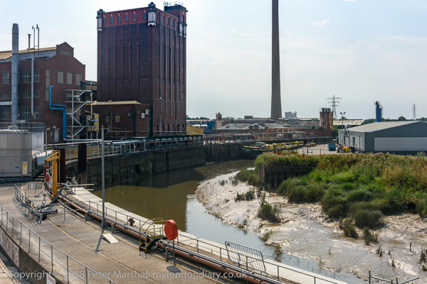
Another former dockyard area still in industrial use. I think this is Thameside Wharf on Harrington Way. Some of the buildings here were once part of the Siemens Brothers Telegraph Works factory established in 1863 and became Thameside studios for artists around 1990.

Bugsby's Way, New Charlton, Greenwich, 1995, 95p5-521
Bugsby’s Way, New Charlton, Greenwich, 1995, 95p5-521

Bugsby’s Way took its name from this part of the River Thames known from around 1830 as Bugsby’s Hole or Bugsby’s Reach which probably got its name from this once “marshy area to the south of Blackwall Point where executed criminals were formerly hung in chains.” As E.W.Green suggested in 1948, ‘bug‘ was the old British (ancient Welsh) word for ‘spook’ or ghost, and what could be a better place to meet with ghouls. Bugsby’s Way was built across this marshy area by the London Borough of Greenwich in 1984.

Beatle Line Ltd, Bugsby's Way, New Charlton, Greenwich, 1995, 95p5-511
Beatle Line Ltd, Bugsby’s Way, New Charlton, Greenwich, 1995, 95p5-511

Another picture from Bugsby’s Way. The Beatle Line perhaps got its name from the later meaning of ‘bug’, perhaps from a different Anglo-Saxon root, at first simply meaning beatle, though later coming into popular use for a wider range of species – including the famous moth found by Grace Hopper and colleagues in the Mark II computer at Harvard University in 1947.

More pictures from Charlton in a later post.


FlickrFacebookMy London DiaryHull PhotosLea ValleyParis
London’s Industrial HeritageLondon Photos

All photographs on this page are copyright © Peter Marshall.
Contact me to buy prints or licence to reproduce.


More River Hull, Lime St and Wincolmlee 1989

Monday, March 25th, 2024

More River Hull, Lime St and Wincolmlee – pictures made in August 1989

Clarence Mill, Drypool Bridge, Dry Dock, River Hull, Hull, 1989 89-8f-61

Looking across the River Hull from the riverside path through the scrap metal you can see the Drypool Bridge and the converted warehouses on Clarence Street between High St and the River. Further to the right are the gates of a dry dock and I think the chimneys of Blaydes House, now the University of Hull Maritime History Institute at I High St.

Dry Dock, River Hull, Hull, 1989 89-8f-62

Swinging around a little brings a second set of dock gates into view, and this was the entrance to Hull’s first inland dock, needed as the Old Harbour on the river bank was getting far too congested. The Hull Dock company, founded in 1783 and the first of its kind, built the dock and opened it in 1788 simply as the Dock. It was built close to the site of Hull’s medieval walls and the street just to the south of the former dock is still called North Walls. The dock was renamed Queen’s Dock when Victoria visited in 1854 and all but the short section between the river and Dock Office Row was filled in in the 1930s and reopened as Queens Gardens in 1935.

Dry Docks, Hull College, River Hull, Hull, 1989 89-8f-63

The Yorkshire Dry Dock Co Ltd, Ship Builders Ship Repairers were incorporated in 1917, but there had been dry docks here much earlier as a detailed study in Paul Gibson’s Hull and East Yorkshire History relates. Hull’s Arctic Corsair, currently being restored, is expected to open to visitors at North End Shipyard in early 2025.

Works, Lime St, Hull, 1989 89-8f-54

Lime street runs parallel with the River Hull on its east side from North Bridge to Scott Street Bridge, and then on to the busy industrial Cleveland Street, always in the 1980s one of Hull’s dustiest streets. Between Lime Street and the river were a number of wharves and many were still in use in 1989, and some businesses here still had some maritime connection.

This picture is looking south down Lime Street from its junction with Jenning Street. I turned into Jenning Street. There are some bulk storage tanks and timber storing sheds in the middle distance and three large of cranes suggesting some large redevelopment.

Scott St Bridge, Hull, 1989

Back in 1989 I was still able to cross the river on Scott Street Bridge. I think Hull Council had long wanted to close this Grade II listed hydraulic double leaf bascule bridge and had deliberately failed to maintain it, allowing salt water to corrode its mechanism. Finally in 1994 they pronounced it unsafe.

It hit the national headlines in January 2018, when Banksy came to to Hull and drew a figure of a young boy brandishing a pencil for a sword called “Draw the Raised Bridge”. The council removed the Banksy in October 2019 and then demolished the bridge completely. Some noises were made by the council about replacing it with a replica, but don’t hold your breath.

Pauls Agriculture Ltd, Wincolmlee, Hull, 1989 89-8f-42

A man cycles down the Scott Street Bridge approach with its warning lights for bridge openind. On the other side of the long railing is Wincolmlee, the street which follows the River Hull on its west side.Two Buildings belonging to Pauls Agriculture Ltd are linked across the street by a bridge.

Pauls Agriculture was founded in Ipswich in the early 19th century initially as traders in malt and barley, but by the twentieth century there main business as in maize, which they crushed to produce vegetable oils for soap and other industrial uses with the remaining oil cake being used to produce animal feeds. In 1992 they merged with BOCM.

Much of the maize was imported, from the USA and elsewhere, so a riverside site made sense. But when transport by road took over it made more sense to site crushing mills in agricultural areas.

More to follow from Hull in August 1989 – and there are more pictures on Flickr in both black and white and colour.


FlickrFacebookMy London DiaryHull PhotosLea ValleyParis
London’s Industrial HeritageLondon Photos

All photographs on this page are copyright © Peter Marshall.
Contact me to buy prints or licence to reproduce.


Hull Colour – 8

Sunday, July 19th, 2020
Barges in River Hull, Stoneferry, Hull 81-04-Hull-051_2400

More barges on the River Hull, moored around the bend just north of the Isis Oil Mills. Here’s that same bend in 2018:

All of the barges are in the green and yellow colour scheme of Hull’s Gillyott and Scott, formed in 1964 by amalgamation of the five companies of William Gilyott, John A. Scott, T.F. Wood, Furleys and John Deheer.

Some of the barges had the names of birds – such as No 129 Ring Plover at the centre of the group above. Others had to make do with just a simple number or a letter and number such as R50 here. Perhaps it depended on which company they had come from.

Warehouse, River Hull, 83-01-Hull-061_2400
Warehouse, River Hull, 1983

This warehouse on the bank of the River Hull had its frontage on High St, immediately upstream from Drypool Bridge. The narrow passage of Blaides Staithe separates it from Blaydes House, the rear of which can be seen at the right of the picture.

Not long after I photographed it, the warehouse was demolished, its site remaining undeveloped when I last visited it 35 years later, though then said to be ‘Under Offer’. In London it would almost certainly have been preserved, probably listed and converted into luxury flats, but Hull’s low property prices signed its death warrant.

Kenfig, dredger, River Hull, Hull 83-01-Hull-062_2400
Kenfig, dredger, River Hull, 1983

I took quite a few photographs of the Kenfig, which seemed to be moored and quietly rusting in the River Hull for several years, though I think it had previously been responsible for some of the dredging of Humber Dock for the new marina.

I wrote the following when I was commenting daily on a picture of Hull during the 2017 year as City of Culture:

The Kenfig, a grab hopper dredger built in 1954 by Henry Scarr Ltd of Hessle for the British Transport Docks Board at Port Talbot. It was one of the dredgers used to clear the passage into Humber Dock for the Marina, and in 1983 was bought by Jones & Bailey Contractors Ltd of Hull who renamed her Hedon Sand in 1984. Around 5 years later she was scrapped at New Holland.

Kenfig was moored just a little upstream of Drypool Bridge on the River Hull for most of the 1980s, seldom if ever moving.

Hook Sand, Dry Dock, Hull 83-01-Hull-067_2400

There are still several dry docks on the lower part of the River Hull, though I think none currently in use, with one scheduled in 2023 to be the centre of a new maritime museum, where it will house Hull’s last sidewinder trawler the Arctic Corsair.

This one is on the opposite side of the river, north of Drypool Bridge and my picture is taken from its road entrance on Great Union St.

The Old Harbour, River Hull, evening. 83-01-Hull-077_2400
The Old Harbour, River Hull, evening. 1983

My apologies for the poor technical quality of this image, which reflects the difference between colour films and the quality we now get from digital images. I think this was probably taken on an ISO400 colour film, while with my current digital camera I would happily work at ISO6400 and get considerably superior results. Photographers will understand this is a difference of five stops. I couldn’t use a very slow shutter speed as the small tanker was moving up river at some speed with the tide.

The view here is looking towards the mouth of the River Hull. The sand and gravel works have now gone and there is a rather ugly hotel on that side of the river. Further down, past the Myton Bridge, built in 1979 and the tidal barrier, the land at Sammy’s Point is now occupied by The Deep.

More pictures at Hull Colour 1972-85 on Flickr.


All photographs on this and my other sites, unless otherwise stated, are taken by and copyright of Peter Marshall, and are available for reproduction or can be bought as prints.