Garford Street Limehouse: My walk in Limehouse on Sunday 6th January 1990 continued. The previous post from this walk is Around Emmett Street, Limehouse 1990. As usual you can click on the images here to view larger versions on my Flickr pages.

Garford Street is variously described as in Limehouse, Westferry and Poplar, although estate agents seem to prefer Canary Wharf, which is certainly isn’t, though fairly close by. Back in 1990 I think most of us thought it was Limehouse.
The 1994 LCC Survey of London deals with it in a chapter Limehouse Hole: The inland area. This tells us that a John Garford in the early 19th century had a wharf on the Thames at its western end on Emmett Street. Since the building of the Limehouse Link tunnel and the new route of Westferry Road for the Canary Wharf redevelopment it now starts around 200 yards to the east on Westferry Road. Its other end is still at the West India Dock Road.
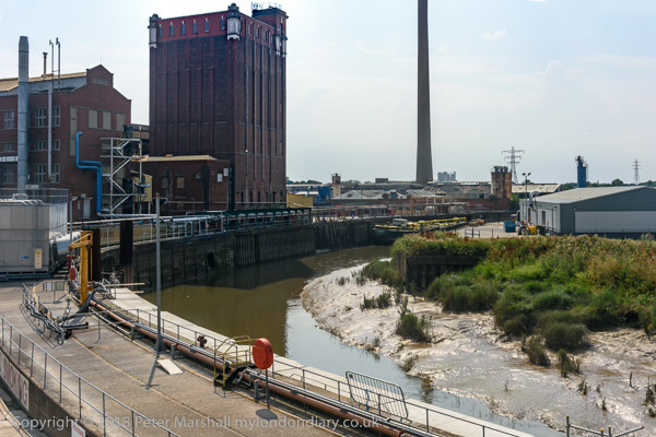
I think the junction here is a part of the lost area on the north side of Garford Street. The chimney in the background is a remnant of the Lion Works, established here in “1896-7 by James Walker & Company, steam packing makers,” later Lion Packings Ltd who made “Patent metallic packing” here until around 1926. “The site was cleared for public housing in 1938–9” but as you can see the chimney survived until 1990.

Another view just a few yards from the previous image shows some large cable drums from AEI Gravesend. A notice tells those waiting for MOT tests at the Austin Rover garage where to queue.

This derelict warehouse building still has the remains of a hoist to the first floor entrance above its main door. There is now new housing on this site just to the west of the DLR railway bridge on the north side of the street.

These early 19th century houses on the south side of Garford St are Grade II listed.

Greig House, Garford St, Limehouse, Tower Hamlets, 1990, 90-1c-56
Greig House, Garford St, Limehouse, Tower Hamlets, 1990,
Built 1902-3 as accommodation for officers from Scandinavian ships docked in London it was taken over in 1930 as a Salvation Army hostel, and later used to house male alcoholics and more recently as a residential detoxification centre for men and women with drug or alcohol problems. Grade II listed along with the cottages on Garford St.

Greig House, Garford St, Limehouse, Tower Hamlets, 1990, 90-1c-41
A second view of Greig House which shows some of the buildings of the West India Dock on Hertsmere Road in the background as well as the cranes building parts of Canary Wharf around Cabot Square. You can read much more about this and the associated buildings on the Lost Hospitals of London site.
From here I walked across the West India Dock Road in Poplar where my next post on this walk will begin.
Flickr – Facebook – My London Diary – Hull Photos – Lea Valley – Paris
London’s Industrial Heritage – London Photos
All photographs on this page are copyright © Peter Marshall.
Contact me to buy prints or licence to reproduce.