Limehouse Workshop – 2005

Limehouse Workshop: Twenty years ago today I led a small workshop of photographers around parts of Limehouse, stopping at a number of key places where I gave a short introduction and some suggestions then set them free for a quarter of an hour or so to take their pictures. And while I then gave those who seem to need it some support I also found time to make some pictures myself.

Limehouse Workshop - 2005

This was an area I’d photographed on a number of occasions over the years – and of course had revisited shortly before the workshop to check and plan our route. And on the day I made sure to be there well in advance in case there were any problems with transport across London. For once there weren’t and I arrived in time for an hour or so wandering and making pictures before we met up.

Limehouse Workshop - 2005
Canary Wharf tower and footbridge over Rotherhithe tunnel

Because of the preparation the workshop went smoothly and I also had a lot of material to write a post on My London Diary – though a lot less than I told people on the workshop about the area. Here it is below with the usual corrections.

Limehouse Workshop - 2005
New flats built on top of LImehouse Link tunnel at Regents Canal Dock (Limehouse Dock), with DLR train.

Limehouse is an area of London, with a varied population and an interesting history. it grew up around the river and seafaring trades, including ship-building, and had many warehouses and similar buildings. as well as the river Thames with its national and international connections (the first voluntary passengers to Australia are said to have left from Dunbar Wharf, close to Limekiln Dock.) It gained more traffic through its two canals, the Regent’s Canal linking the Thames to inland England, including Birmingham and the midlands via the Grand Union Canal, and the Limehouse Cut, taking traffic from the Lea Navigation to the Thames by a safer route avoiding Bow Creek.

Limehouse Workshop - 2005

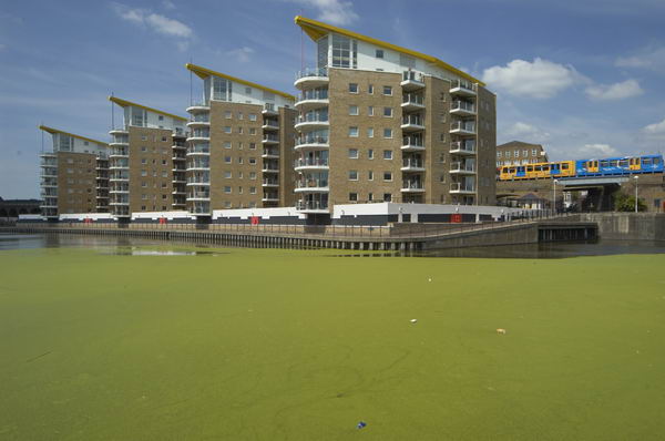
Much of the centre of Limehouse is occupied by the Regents Canal Dock. In the 1960s a new short length of canal joined the Limehouse Cut to this, enabling the separate lock from this to the Thames to be closed. A year or two later all commercial traffic on the canals ceased, leaving them for pleasure cruising.

Limehouse Workshop - 2005

A hundred years ago, docklands in general and Limehouse in particular was a closed world to those who lived outside the area. Lurid and racist stories, particularly those of Sax Rohmer, painted the area as a den of vice, run by the infamous (and totally fictional) Dr Fu Manchu. The area had become home to a number of Chinese and Asian sailors and their families, becoming London’s first Chinatown. Even thirty years ago there were still some signs of this, but [by 2005] most of the Chinese businesses and people have moved away to other areas, including Soho.

St Anne’s, Limehouse flying its naval White Ensign

Thomas Burke’s tales of Limehouse [Limehouse Nights: Tales of Chinatown] from the same era as Rohmer paint a more accurate and sympathetic view of the area and its English and Chinese population, although his language is fully of its time, with many terms that would now be considered derogatory. But Burke had been raised as an orphan in neighbouring Poplar and his Limehouse stories reflect a close knowledge of the people and the place. The figure who dominates his stories is not a sinister criminal warlord, but the old Chinese sage, Quong Lee.

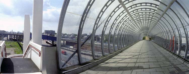
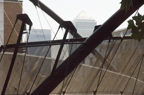
More recently, Limehouse came under the diggers and cranes of the London Docklands Development Corporation. Canary Wharf was raised on its eastern edge, and the Limehouse Link tunnel excavated through the heart of the area. The need to build this route to join docklands with inner London meant that the LDDC had to get round a table with the local authority, leading to the first real attempt by them to take social considerations into account in their development plans.

More pictures and some captions begin here on My London Diary.


FlickrFacebookMy London DiaryHull PhotosLea ValleyParis
London’s Industrial HeritageLondon Photos

All photographs on this page are copyright © Peter Marshall.
Contact me to buy prints or licence to reproduce.


Garford Street Limehouse – 1990

Garford Street Limehouse: My walk in Limehouse on Sunday 6th January 1990 continued. The previous post from this walk is Around Emmett Street, Limehouse 1990. As usual you can click on the images here to view larger versions on my Flickr pages.

Garford St, Limehouse, Tower Hamlets, 1990, 90-1c-65

Garford Street is variously described as in Limehouse, Westferry and Poplar, although estate agents seem to prefer Canary Wharf, which is certainly isn’t, though fairly close by. Back in 1990 I think most of us thought it was Limehouse.

The 1994 LCC Survey of London deals with it in a chapter Limehouse Hole: The inland area. This tells us that a John Garford in the early 19th century had a wharf on the Thames at its western end on Emmett Street. Since the building of the Limehouse Link tunnel and the new route of Westferry Road for the Canary Wharf redevelopment it now starts around 200 yards to the east on Westferry Road. Its other end is still at the West India Dock Road.

I think the junction here is a part of the lost area on the north side of Garford Street. The chimney in the background is a remnant of the Lion Works, established here in “1896-7 by James Walker & Company, steam packing makers,” later Lion Packings Ltd who made “Patent metallic packing” here until around 1926. “The site was cleared for public housing in 1938–9” but as you can see the chimney survived until 1990.

Garford St, Limehouse, Tower Hamlets, 1990, 90-1c-51

Another view just a few yards from the previous image shows some large cable drums from AEI Gravesend. A notice tells those waiting for MOT tests at the Austin Rover garage where to queue.

Garford St, Limehouse, Tower Hamlets, 1990, 90-1c-53

This derelict warehouse building still has the remains of a hoist to the first floor entrance above its main door. There is now new housing on this site just to the west of the DLR railway bridge on the north side of the street.

Constables Cottages, Garford St, Limehouse, Tower Hamlets, 1990, 90-1c-54

These early 19th century houses on the south side of Garford St are Grade II listed.

Greig House, Garford St, Limehouse, Tower Hamlets, 1990, 90-1c-56

Greig House, Garford St, Limehouse, Tower Hamlets, 1990, 90-1c-56

Greig House, Garford St, Limehouse, Tower Hamlets, 1990,
Built 1902-3 as accommodation for officers from Scandinavian ships docked in London it was taken over in 1930 as a Salvation Army hostel, and later used to house male alcoholics and more recently as a residential detoxification centre for men and women with drug or alcohol problems. Grade II listed along with the cottages on Garford St.

Greig House, Garford St, Limehouse, Tower Hamlets, 1990, 90-1c-41

Greig House, Garford St, Limehouse, Tower Hamlets, 1990, 90-1c-41

A second view of Greig House which shows some of the buildings of the West India Dock on Hertsmere Road in the background as well as the cranes building parts of Canary Wharf around Cabot Square. You can read much more about this and the associated buildings on the Lost Hospitals of London site.

From here I walked across the West India Dock Road in Poplar where my next post on this walk will begin.


FlickrFacebookMy London DiaryHull PhotosLea ValleyParis
London’s Industrial HeritageLondon Photos

All photographs on this page are copyright © Peter Marshall.
Contact me to buy prints or licence to reproduce.


Around Emmett Street, Limehouse 1990

Around Emmett Street, Limehouse: My walk in Limehouse on Sunday 6th January 1990 continued. The previous post from this walk is Three Colt Street & Limekiln Dock – 1990.

Datakeep, Emmet St, Limehouse, Tower Hamlets, 1990, 90-1b-13
Datakeep, Emmett St, Limehouse, Tower Hamlets, 1990, 90-1b-13

You won’t find Emmett Street on a map of Limehouse now. It ran from the southern end of Three Colt Street to meet West Ferry Road a few yards to the north of the Limehouse Entrance and Limehouse Basin the the West India Docks. Along its west side were a number of wharves – Taylor’s Wharf, Aberdeen Wharf, River Plate Wharf etc, the dry docks of Limekiln Dockyard and Limehouse Dry Dock and a dock at Aberdeen Wharf. This area was Limehouse Hole and included Limehouse Stairs from which a ferry once ran to Rotherhithe from what later became called Limehouse Pier.

Milligan St, Limehouse Causeway, Limehouse, Tower Hamlets, 1990, 90-1b-15

Dundee Wharf, Aberdeen Wharf and the River Plate Wharf were were all part of the Dunbar Wharves. They ran regular twice weekly services to Scotland as well as importing goods from around the world – including meat from Argentina, and Oxo cubes were at one time wrapped here.

Datakeep, River Thames, Milligan St, Emmett St, Limehouse, Tower Hamlets, 1990, 90-1b-16

Emmett Street had at some time been known as Limekiln Hill – and West Ferry Road was earlier Bridge Road. These names were still used on the 1870 OS map, although The Survey of London says it was known as Emmett Street about 1830.

Datakeep, Emmett St, Limehouse, Tower Hamlets, 1990, 90-1c-63

The land in this area was owned by the Emmett family who began selling it off in 1809 but their name remained on the street until it was completely obliterated with the building of the Limehouse Link Tunnel shortly after I made these pictures.

Datakeep, Emmett St, Limehouse, Tower Hamlets, 1990, 90-1c-64

Much of the area had been cleared earlier by wartime bombing and the some large warehouses were rebuilt in the following years. The remaining 1870s warehouses were demolished in 1971-2 and the rest destroyed for the building of the road tunnel and Canary Riverside including Westferry Circus. You can read a detailed and well-illustrated article Limehouse Hole by Mick Lemmerman on the Isle of Dogs web Site.

Datakeep set out to provide secure storage for computer backup tapes in the largest warehouse in the area, formerly use for tea and coffee. The company later stored all kinds of things, including a 1935 vintage Bentley and offered a wide range of services to companies for their stored items.

More from Limehouse in a later post.


FlickrFacebookMy London DiaryHull PhotosLea ValleyParis
London’s Industrial HeritageLondon Photos

All photographs on this page are copyright © Peter Marshall.
Contact me to buy prints or licence to reproduce.


More from Narrow Street – 1990

More from Narrow Street – 1990: My walk in Limehouse on Sunday 6th January 1990 continued. The previous post from this walk is Around Narrow Street, Limehouse – 1990

Dunbar Wharf, Narrow St, Limehouse, Tower Hamlets, 1990, 90-1b-62

It was hard not to take picture after picture on Narrow Street, particularly as I was aware much was soon to disappear, and I made over 20 exposures, though I’ve digitised less than half of these, and I’ll only post a few of these as some of the others are rather similar or at least overlap in terms of subject. This view shows some of the same buildings from the picture that ended the previous post, but from a slightly different viewpoint. Most including all in this view ,were demolished shortly afterwards.

Dunbar Wharf, Narrow St, Limehouse, Tower Hamlets, 1990, 90-1b-45
Listed properties in Dunbar Wharf, Narrow St, Limehouse, Tower Hamlets, 1990, 90-1b-45

My previous post told the story of Duncan Dunbar and his son of the same name who built up a huge shipping empire based around Dunbar Wharf but sold off at his death in 1862. The four warehouses at 136, 136½, 138, 140 were Grade II listed in 1973 and some at least were still in various commercial use back in 1990.

Until the 1970s it was a working wharf – E W Taylor, a lighterage company had begun using it for oversize cargo in 1857 – and the company also “became experts in the warehousing and fumigation of the botanicals used in making gin.” The company, now part of Dunbar Wharf Holdings Limited, acquired Dunbar Wharf in the 1940s.

Barlow & Sons, Dunbar Wharf, Narrow St, Limehouse, Tower Hamlets, 1990, 90-1b-46

All the remaining properties in Dunbar Wharf have now been converted into flats and you can read online about the 2020 renovation of one of the 1790s warehouse buildings into “a beautiful residence by the Thames.”

Barlow and Sons Auto Repairs were at 144 Narrow Street and offered their auto repairs with the aid of some really king-size spanners. This building was replaced in 1997 by Creek House.

Narrow St, Limehouse, Tower Hamlets, 1990, 90-1b-51

These buildings were demolished shortly after I made these photographs for the development of the Limehouse Link tunnel and were then replaced by modern flats with a vaguely pastiche frontage. Their demolition enabled archaeological investigation of the site of Joseph Wilson and Company’s Limehouse Porcelain Manufactory operating here from 1745-8.

St Dunstan's Wharf, Narrow St, Limehouse, Tower Hamlets, 1990, 90-1b-44
St Dunstan’s Wharf, Narrow St, Limehouse, Tower Hamlets, 1990, 90-1b-44

St Dunstan’s Wharf at 142 Narrow Street is also Grade II listed and has survived. Together with the listed buildings of Dunbar Wharf it backs onto Limekiln Dock. Above the doorway is its name and a floral decoration together with what appears to be a large pair of blacksmiths’ tongs, the pincers used by St Dunstan to grab the together with another tool I don’t recognise.

Along is bottom are the initials W & G.G and the date 1878. Gardner & Gardner, hay & straw salesmen, are listed at this address as well as in Spread Eagle Yard in Whitechapel High Street. The listing text states this is on a metal plate, but it looks more like terracotta in my picture. Apparently the building was also used as a store for materials including juniper berries and flowers used to make gin.

I was more or less at the end of Narrow Street and my walk will continue along Three Colt Street in another post.


FlickrFacebookMy London DiaryHull PhotosLea ValleyParis
London’s Industrial HeritageLondon Photos

All photographs on this page are copyright © Peter Marshall.
Contact me to buy prints or licence to reproduce.


Limehouse Basin and Limehouse Cut – 1990

Limehouse Basin and Limehouse Cut: More pictures from my walk around Limehouse on on 6th January 1990. The previous post from this walk is Ratcliff Highway and Limehouse Basin – 1990.

Former Limehouse Cut, Northey St, Narrow St, Limehouse, Tower Hamlets, 1990, 90-1a-24
Former Limehouse Cut, Northey St, Narrow St, Limehouse, Tower Hamlets, 1990

The Limehouse Cut is London’s oldest canal, opened in 1770 to provide an easier route from the Lea Navigation, an important river for transporting grain into London from the agricultural areas to north in Hertfordshire. Used from the Bronze age and later by Viking raiders, alterations had been made to improve navigation on the River Lee since at least 1190 and was later followed by various Acts of Parliament. The first river lock in England was built on it at Waltham Abbey in 1577, but it was only the the River Lee Navigation Act 1767 that really began its modernisation.

Former Limehouse Cut, Northey St, Narrow St, Limehouse, Tower Hamlets, 1990, 90-1a-41

Part of the work made under the 1767 Act when the navigation was surveyed John Smeaton was the suggestion to dig of the Limehouse Cut, allowing boats to avoid the treacherous and winding tidal lower reaches of Bow Creek on their way to the River Thames. The actual surveyor when the work began was his assistant Thomas Yeoman. It was a considerable short cut as it emerged into the river to the west of the long haul around the Isle of Dogs.

The original canal was narrow and had to be later widened and improved and it was only in the Victorian era that it was finally in something like its final state. The canal until 1968 entered directly into the Thames though Limehouse Lock in front of the row of small houses in these pictures, but it also had a basin, Limehouse Basin, at its southern end.

Limehouse Dock, Limehouse, Tower Hamlets, 1990, 90-1a-45
Limehouse Basin, Limehouse, Tower Hamlets, 1990, 90-1a-45

The first Limehouse Basin was at first simply a basin at the end of the Limehouse Cut, dug out by 1795. It had an island in it and on its bank was a a sawmill driven by a windmill, built a little earlier when sawmills were still widely thought to be illegal in England. It was attacked and the machinery destroyed by rioters – including hand-sawyers – in 1768. Restored the following year it closed around 35 years later. A lead mill opened on the island soon after and the company only ceased to exist in 1982. Victory Place is built on the site of this original Basin, and the old streets Island Row and Mill Place to its north are still there.

The Limehouse Cut was in 1854 linked to the Limehouse Basin of the Regent’s Canal which had opened in 1820 as the Limehouse Lock needed to be repaired. But this link was opposed by the boatmen from the Lee and Stort who fought a legal battle and in 1864 it was filled in and the site built on. It was not until over a hundred years later in 1968 that a new link – only 200 metres long – was made and Limehouse Lock finally closed.

Limehouse Cut, Limehouse, Tower Hamlets, 1990, 90-1a-32

The Limehouse Cut runs on a straight route through Poplar but curves around at its sourthern end. It was blocked here in 1990, probably in connection with the buildilng of the Limehouse Link tunnel between 1989 and 1993. But there was also work on the Cut around then, with the vertical guillotine gate on the north side of Britannia Bridge across the Commercial Road being removed.

Northey St, Limehouse, Tower Hamlets, 1990, 90-1a-32
Limehouse Cut, Limehouse, Tower Hamlets, 1990, 90-1a-32

Northey Street still has a bridge over the remains of the old route of the Limehouse Cut to Limehouse Lock, but all of the buildings including wharves and works on the banks of the Cut have now been replaced by modern development. The tower blocks beyond are on Oak Lane, and I think in the distance are cranes working on developments on the Isle of Dogs around Canary Wharf.

Northey St, Limehouse, Tower Hamlets, 1990, 90-1a-36

Another view of buildings on Northey Street in the 1990s.

Still more from Limehouse to come in later posts.


FlickrFacebookMy London DiaryHull PhotosLea ValleyParis
London’s Industrial HeritageLondon Photos

All photographs on this page are copyright © Peter Marshall.
Contact me to buy prints or licence to reproduce.


Church, Pyramid, Star of the East – More Limehouse

St Anne's Church, Limehouse, Tower Hamlets, 1988 88-7o-32-positive_2400
St Anne’s Church, Limehouse, Tower Hamlets, 1988 88-7o-32

Church, Pyramid, Star of the East – More Limehouse
My walk around Limehouse came back to the area I think of as its heart, close to St Anne’s Church, one of the Queen Anne Churches built after the 1711 Act of Parliament and consecrated in 1730. St Anne’s is one of the six London churches by Nicholas Hawksmoor along with St Alfege’s Greenwich, St George’ Bloomsbury, Christ Church, Spitalfields, St George in the East Wapping andhis only church in the City of London, St Mary Woolnoth.


St Anne's Churchyard, St Anne's Passage, Limehouse, Tower Hamlets, 1988  88-7o-34-positive_2400
St Anne’s Churchyard, St Anne’s Passage, Limehouse, Tower Hamlets, 1988 88-7o-34

I turned my back on the church to photograph the entrance gate to the churchyard.

Limehouse Pyramid, St Anne's Church, Limehouse, Tower Hamlets, 1988  88-7o-36-positive_2400
Limehouse Pyramid, St Anne’s Church, Limehouse, Tower Hamlets, 1988 88-7o-36

The church has featured in many books and publications, including the work of psychogeographers and other more esoteric and mystical writers, and seems to have a special place in the works of believers in ley lines. I’ve not read or seen the film ‘Dark Lines Of London’, but a web page claims to give “Factual Information That Provides the Backdrop to the Story” and includes descriptions and photographs of 10 sites, all from centuries after that in which the story is set, along “a real ley line” one of which is this “Wisdom Of Solomon” Pyramid.

Princes Lodge, Commercial Rd, Limehouse, Tower Hamlets, 1988  88-7o-22-positive_2400
Princes Lodge, Commercial Rd, Limehouse, Tower Hamlets, 1988 88-7o-22

THE 4TH CONFERENCE of the Situationist International was held in London, at a secret address in the East End, 24-28 September 1960, seventeen months after the Munich Conference (April 1959). The situationists assembled in London were: Debord, Jacqueline de Jong, Jorn, Kotányi, Katja Lindell, Jörgen Nash, Prem, Sturm, Maurice Wyckaert and H.P. Zimmer. In fact, to ensure that the proceedings were kept well away from any contact with London journalists or artistic circles, the conference took place at the British Sailors Society hall in Limehouse, “an area famous for its criminals”.

Internationale Situationniste #5

Star of the East, Commercial Rd, Limehouse, Tower Hamlets, 1988  88-7o-23-positive_2400
Star of the East, Commercial Rd, Limehouse, Tower Hamlets, 1988 88-7o-23

Built in the early 19th century and Grade II listed the Star of the East was serving beer at least from 1845. More recently the building had deteriorated and closed as a pub around 2010, was reopened a couple of years later but closed again in 2016. The pub was then taken over and refurbished by the Old Spot Pub Co, who run around a dozen pubs re-opening again in 2019.

Star of the East, Commercial Rd, Limehouse, Tower Hamlets, 1988  88-7o-11-positive_2400
Star of the East, Commercial Rd, Limehouse, Tower Hamlets, 1988 88-7o-11

You can read more about its recent transformation and see some photographs from London Pub Explorer. I’ve yet to return to see for myself. Back in 1988 part of the building was a separate restaurant, but I think the pub now occupies the whole building. The refurbishment appears to have kept at least some of the original interior features.

Bate St, Three Colt St, Limehouse, Tower Hamlets, 1988  88-7o-14-positive_2400
Three Colt St, Limehouse, Tower Hamlets, 1988 88-7o-14

Three Colt St, which has St Anne’s Church at its northern end is one of the oldest roads in the area, part of the route from Limehouse to Stepney and first recorded in 1362. In the Victorian era it was flanked by a number of shops and was something of a middle-class enclave surrounded on both sides by extreme poverty. Little remains from those times. The building here is the former London and Blackwall Railway station, probably dating from the opening of the railway in 1840. The station closed in 1926, but the line remained in use for goods traffic until the 1960s. When the line was reused for the Docklands Light Railway in 1987, Westferry station was built around 300 yards to the east.

Emmett St, Limehouse, Tower Hamlets, 1988 88-7o-16-positive_2400
Emmett St, Limehouse, Tower Hamlets, 1988 88-7o-16

Not only this building but the street that it was in have disappeared since I made this picture. Emmett St was at the end of Three Colt St, roughly where the Limehouse Link tunnel entrance is now. Construction of the tunnel began in November 1989 and the project was officially opened in May 1993, at £293,000,000 the most expensive per mile road scheme ever built in the UK, a huge public subsidy to the Canary Wharf redevelopment.

When Mucho Macho released ‘The Limehouse Link’ in 1998 it had one of my pictures wrapped around both the CD and the 12″ LP, where it looked rather more impressive. But this image was from Poplar – and this is the full image from the Urban Landscapes web site and doesn’t show the Limehouse Link at all.


Clicking on any of the black and white images above will take you to a larger version in my 1988 London Photos from where you can browse the album.