Limehouse Workshop – 2005

Limehouse Workshop: Twenty years ago today I led a small workshop of photographers around parts of Limehouse, stopping at a number of key places where I gave a short introduction and some suggestions then set them free for a quarter of an hour or so to take their pictures. And while I then gave those who seem to need it some support I also found time to make some pictures myself.

Limehouse Workshop - 2005

This was an area I’d photographed on a number of occasions over the years – and of course had revisited shortly before the workshop to check and plan our route. And on the day I made sure to be there well in advance in case there were any problems with transport across London. For once there weren’t and I arrived in time for an hour or so wandering and making pictures before we met up.
Limehouse Workshop - 2005
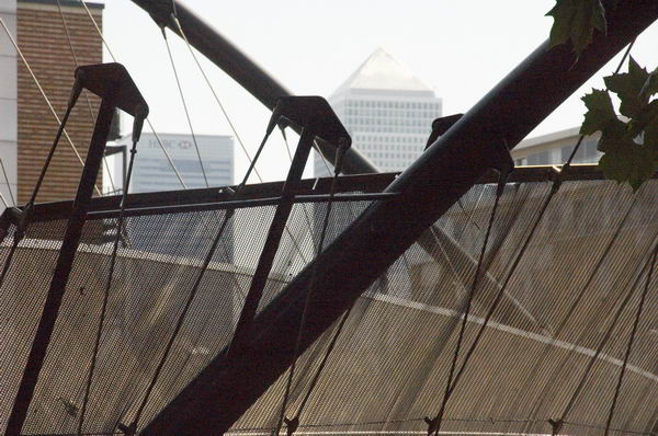
Canary Wharf tower and footbridge over Rotherhithe tunnel

Because of the preparation the workshop went smoothly and I also had a lot of material to write a post on My London Diary – though a lot less than I told people on the workshop about the area. Here it is below with the usual corrections.
Limehouse Workshop - 2005
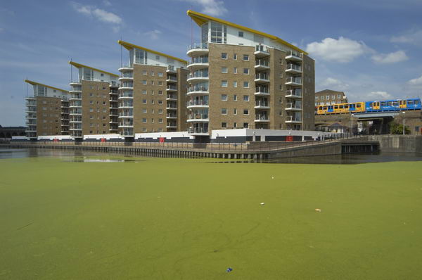
New flats built on top of LImehouse Link tunnel at Regents Canal Dock (Limehouse Dock), with DLR train.

Limehouse is an area of London, with a varied population and an interesting history. it grew up around the river and seafaring trades, including ship-building, and had many warehouses and similar buildings. as well as the river Thames with its national and international connections (the first voluntary passengers to Australia are said to have left from Dunbar Wharf, close to Limekiln Dock.) It gained more traffic through its two canals, the Regent’s Canal linking the Thames to inland England, including Birmingham and the midlands via the Grand Union Canal, and the Limehouse Cut, taking traffic from the Lea Navigation to the Thames by a safer route avoiding Bow Creek.

Limehouse Workshop - 2005

Much of the centre of Limehouse is occupied by the Regents Canal Dock. In the 1960s a new short length of canal joined the Limehouse Cut to this, enabling the separate lock from this to the Thames to be closed. A year or two later all commercial traffic on the canals ceased, leaving them for pleasure cruising.

Limehouse Workshop - 2005

A hundred years ago, docklands in general and Limehouse in particular was a closed world to those who lived outside the area. Lurid and racist stories, particularly those of Sax Rohmer, painted the area as a den of vice, run by the infamous (and totally fictional) Dr Fu Manchu. The area had become home to a number of Chinese and Asian sailors and their families, becoming London’s first Chinatown. Even thirty years ago there were still some signs of this, but [by 2005] most of the Chinese businesses and people have moved away to other areas, including Soho.

St Anne’s, Limehouse flying its naval White Ensign

Thomas Burke’s tales of Limehouse [Limehouse Nights: Tales of Chinatown] from the same era as Rohmer paint a more accurate and sympathetic view of the area and its English and Chinese population, although his language is fully of its time, with many terms that would now be considered derogatory. But Burke had been raised as an orphan in neighbouring Poplar and his Limehouse stories reflect a close knowledge of the people and the place. The figure who dominates his stories is not a sinister criminal warlord, but the old Chinese sage, Quong Lee.

More recently, Limehouse came under the diggers and cranes of the London Docklands Development Corporation. Canary Wharf was raised on its eastern edge, and the Limehouse Link tunnel excavated through the heart of the area. The need to build this route to join docklands with inner London meant that the LDDC had to get round a table with the local authority, leading to the first real attempt by them to take social considerations into account in their development plans.

More pictures and some captions begin here on My London Diary.


FlickrFacebookMy London DiaryHull PhotosLea ValleyParis
London’s Industrial HeritageLondon Photos

All photographs on this page are copyright © Peter Marshall.
Contact me to buy prints or licence to reproduce.


Limehouse Cut – 1990

The final post on walk in Limehouse on Sunday 6th January 1990 continued. The previous post from this walk is West India Dock Road & Limehouse Cut – 1990. As usual you can click on the images here to view larger versions on my Flickr pages.

Limehouse Cut, Railway viaduct, Limehouse, Tower Hamlets, 1990, 90-1c-12

Looking south towards the blockage across the canal through the bridge which carries the DLR over Limehouse Cut. At the right are the temporary buildings for the construction work on the Limehouse Link tunnel. The Limehouse Cut turns around to the right past the blockage to join Limehouse Dock and I think the industrial buildings you can see are in Brightlingsea Street.

Flood Barrier, Limehouse Cut, Limehouse, Tower Hamlets, 1990, 90-1c-15

I walked along the towpath to Commercial Road carried over the canal by Britannia Bridge, named for the Britannia Tavern which stood here until 1911, when it was probably removed to allow the bridge to be widened for traffic and also to allow for a towpath under the bridge.

At spring tides when the water rose to its highest it would overtop the old Bow Locks, with water flowing into both the Cut and the lower stretch of the Lea Navigation. This created a problem, particularly when the Cut was connected to the Limehouse Dock. In this picture you see the vertical guillotine gate which was fitted here after the Cut was taken over by British Waterways in 1948 enabling the canal to be isolated from the dock. It was removed soon after I made this picture.

You can also see the 1923 Empire Memorial Sailors’ Hostel on the corner of Commercial Road and Salmon Lane, built as a memorial to all the seamen who had lost their lives in the First World War. Later used as a hostel for the homeless and to house immigrants it had by 1990 been converted into luxury flats.

H W Bush, Mill Place, Limehouse, Tower Hamlets, 1990, 90-1c-16
Island Row, Mill Place, Limehouse, Tower Hamlets, 1990, 90-1f-66
Limehouse Basin, Northey St, Narrow St, Limehouse, Tower Hamlets, 1990, 90-1f-65

Taken from near to the end of Island Row. But my walk was coming to an end. I made only one more black and white picture, not yet digitised, of the Regents Canal Lock from Commercial Road on my way to Limehouse station.

But I had also carried a second camera body loaded with colour negative film and I made the occasional colour picture during the walk. Here are four of them:

Stepney Transforming Station, Brightlingsea Place, Limehouse, Tower Hamlets, 1990, 90c01-01-73
Poplar Fish Bar, Poplar, Tower Hamlets, 1990, 90c01-01-62
Everite Autos, Poplar, Tower Hamlets, 1990, 90c01-01-64
Everite Autos Mill Place, Limehouse, Tower Hamlets, 1990, 90c01-01-64
Café, Poplar, Tower Hamlets, 1990, 90c01-01-52

FlickrFacebookMy London DiaryHull PhotosLea ValleyParis
London’s Industrial HeritageLondon Photos

All photographs on this page are copyright © Peter Marshall.
Contact me to buy prints or licence to reproduce.


West India Dock Road & Limehouse Cut – 1990

West India Dock Road & Limehouse Cut: My walk in Limehouse on Sunday 6th January 1990 continued. The previous post from this walk is Garford Street Limehouse – 1990. As usual you can click on the images here (except the panorama) to view larger versions on my Flickr pages.

Shops, West India Dock Road, Limehouse, Tower Hamlets, 1990, 90-1c-42

This area is close to the parish border of Limehouse and Poplar, but in popular imagination was certainly Limehouse, London’s first ‘Chinatown’. But by 1990 Chinatown had almost entirely moved to Soho, though a few elements remained, including the Peking Restaurant – though a few shops down the street is the Poplar Fish Bar.

Davey & Co, 88, West India Dock Road, Limehouse, Tower Hamlets, 1990, 90-1c-43

“In February 1885 Arthur Christopher Davey began a venture that throughout the 20th century evolved into a culture in the manufacture and supply of marine equipment. From humble beginnings in Leadenhall Street, the company soon moved to its famous address at 88, West India Dock Road, London E14, where it successfully traded for over 100 years.” The company is now based in Colchester.

Shops, West India Dock Road, Limehouse, Tower Hamlets, 1990, 90-1c-45

The Wah Ying Restaurant was another remanant of Chinatown – and you can see along the road the sign of the Peking Restaurant. In the distance are the warehouses of the West India Docks and beyond them the cranes building Cabot Square at Canary Wharf.

West India Dock Road was laid out at the same time as the West India Docks opened in 1802, a new road to give access to them, which was for many years a toll road. I think these buildings probably date from the 1870s or a little later after the tolls were removed.

The restaurant looks very much closed and the broken windows above suggest it was empty and derelict when I made this picture.

Blockage, Limehouse Cut, Limehouse, Tower Hamlets, 1990, 90-1c-46

The Limehouse Cut runs on a straight route through Poplar but curves around at its southern end. It was blocked here in 1990, possibly in connection with the building of the Limehouse Link tunnel between 1989 and 1993. But there was also work on the Cut around then, with the vertical guillotine gate on the north side of Britannia Bridge across the Commercial Road being removed.

Poplar Mods, graffiti, Railway Viaduct, St Anne's Church, Limehouse, Tower Hamlets, 1990, 90-1c-32
Poplar Mods, graffiti, Railway Viaduct, St Anne’s Church, Limehouse, Tower Hamlets, 1990, 90-1c-32

The tower of Hawksmoor’s St Annes Limeouse seen above the viaduct built for the London and Blackwall Railway and opened in July 1840, the second or third railway viaduct to be built in London, after the 1836 London to Greenwich viaduct and the the Hanwell viaduct, technically then outside London. The line went to Brunswick Wharf in Blackwall where passengers could board ferries and boats to other destinations down river or around the world.

I can tell you nothing more about Poplar Mods except that the graffiti tells us they are male “Hammers” fans. West Ham began life as a team for the workers of the last remaining shipbuilders in the area not far away on Bow Creek as the Thames Ironworks Football Club. From 1895 they played at Hermit Road in Canning Town, former home to Old Castle Swifts, Essex’s first professional team which had gone bankrupt, They became West Ham United in 1900 and moved to Plaistow, before in 2004 uniting with the Boleyn Castle football club and moving to their Upton Park ground where they stayed until 2016.

Limehouse Cut, Railway viaduct, Limehouse, Tower Hamlets, 1990, 90-1c-21

I think the next few pictures I made were taken from the block of flats immediately to the east of Limehouse Cut, Kiln Court, a medium rise block built as part of the Barley Mow Estate for the GLC in 1965-8. Back in 1990 many blocks still did not have security doors and it was possible to easily access shared areas.

Here you can see the Cut and the DLR viaduct across the north side of Limehouse Dock with its bridge and the Roman Catholic Church of Our Lady Immaculate & St Frederick on the corner of Island Row and Commercial Road.

I think the buildings on the far bank of Limehouse Cut were temporary offices and accommodation for the building of the Limehouse Link tunnel. The site is now occupied by housing at the end of Island Row.

Limehouse Cut, Limehouse Dock, Railway viaduct, Limehouse, Tower Hamlets, 1990, 90-1c-23

In this picture you can see across to Limehouse Dock with the Hydraulic Accumulator Tower next to the DLR viaduct at the right. At the left is the temporary blockage on the Limehouse Link.

Limehouse Cut, Limehouse Dock, Railway viaduct, Limehouse, Tower Hamlets, 1990, 90-1c-24

Sliding my shift lens to the left gave a view a little further towards the south and shows a little more of the Cut past the blockage and in the distance a small glimpse of the River Thames. This image was taken to create a panorama together with 90-1c-23:

Limehouse Cut, Limehouse Dock, Railway viaduct, Limehouse, Tower Hamlets, 1990, 90-1c-23-24

More from Limehouse Cut in the next post on this walk.


FlickrFacebookMy London DiaryHull PhotosLea ValleyParis
London’s Industrial HeritageLondon Photos

All photographs on this page are copyright © Peter Marshall.
Contact me to buy prints or licence to reproduce.


Limehouse Basin and Limehouse Cut – 1990

Limehouse Basin and Limehouse Cut: More pictures from my walk around Limehouse on on 6th January 1990. The previous post from this walk is Ratcliff Highway and Limehouse Basin – 1990.

Former Limehouse Cut, Northey St, Narrow St, Limehouse, Tower Hamlets, 1990, 90-1a-24
Former Limehouse Cut, Northey St, Narrow St, Limehouse, Tower Hamlets, 1990

The Limehouse Cut is London’s oldest canal, opened in 1770 to provide an easier route from the Lea Navigation, an important river for transporting grain into London from the agricultural areas to north in Hertfordshire. Used from the Bronze age and later by Viking raiders, alterations had been made to improve navigation on the River Lee since at least 1190 and was later followed by various Acts of Parliament. The first river lock in England was built on it at Waltham Abbey in 1577, but it was only the the River Lee Navigation Act 1767 that really began its modernisation.

Former Limehouse Cut, Northey St, Narrow St, Limehouse, Tower Hamlets, 1990, 90-1a-41

Part of the work made under the 1767 Act when the navigation was surveyed John Smeaton was the suggestion to dig of the Limehouse Cut, allowing boats to avoid the treacherous and winding tidal lower reaches of Bow Creek on their way to the River Thames. The actual surveyor when the work began was his assistant Thomas Yeoman. It was a considerable short cut as it emerged into the river to the west of the long haul around the Isle of Dogs.

The original canal was narrow and had to be later widened and improved and it was only in the Victorian era that it was finally in something like its final state. The canal until 1968 entered directly into the Thames though Limehouse Lock in front of the row of small houses in these pictures, but it also had a basin, Limehouse Basin, at its southern end.

Limehouse Dock, Limehouse, Tower Hamlets, 1990, 90-1a-45
Limehouse Basin, Limehouse, Tower Hamlets, 1990, 90-1a-45

The first Limehouse Basin was at first simply a basin at the end of the Limehouse Cut, dug out by 1795. It had an island in it and on its bank was a a sawmill driven by a windmill, built a little earlier when sawmills were still widely thought to be illegal in England. It was attacked and the machinery destroyed by rioters – including hand-sawyers – in 1768. Restored the following year it closed around 35 years later. A lead mill opened on the island soon after and the company only ceased to exist in 1982. Victory Place is built on the site of this original Basin, and the old streets Island Row and Mill Place to its north are still there.

The Limehouse Cut was in 1854 linked to the Limehouse Basin of the Regent’s Canal which had opened in 1820 as the Limehouse Lock needed to be repaired. But this link was opposed by the boatmen from the Lee and Stort who fought a legal battle and in 1864 it was filled in and the site built on. It was not until over a hundred years later in 1968 that a new link – only 200 metres long – was made and Limehouse Lock finally closed.

Limehouse Cut, Limehouse, Tower Hamlets, 1990, 90-1a-32

The Limehouse Cut runs on a straight route through Poplar but curves around at its sourthern end. It was blocked here in 1990, probably in connection with the buildilng of the Limehouse Link tunnel between 1989 and 1993. But there was also work on the Cut around then, with the vertical guillotine gate on the north side of Britannia Bridge across the Commercial Road being removed.

Northey St, Limehouse, Tower Hamlets, 1990, 90-1a-32
Limehouse Cut, Limehouse, Tower Hamlets, 1990, 90-1a-32

Northey Street still has a bridge over the remains of the old route of the Limehouse Cut to Limehouse Lock, but all of the buildings including wharves and works on the banks of the Cut have now been replaced by modern development. The tower blocks beyond are on Oak Lane, and I think in the distance are cranes working on developments on the Isle of Dogs around Canary Wharf.

Northey St, Limehouse, Tower Hamlets, 1990, 90-1a-36

Another view of buildings on Northey Street in the 1990s.

Still more from Limehouse to come in later posts.


FlickrFacebookMy London DiaryHull PhotosLea ValleyParis
London’s Industrial HeritageLondon Photos

All photographs on this page are copyright © Peter Marshall.
Contact me to buy prints or licence to reproduce.

Spratt’s, Far Famed Cakes and Bromley by Bow

Spratt’s, Far Famed Cakes and Bromley by Bow. My walk on 31st February 1988 was coming to an end as I made my way towards Bromley-by-Bow District Line station to begin my journey home. You can see the previous part at Lansbury, Brownfield, Teviot and St Leonards Road.

Footbridge, Railway, Spratt's Patent, Clutton St, Poplar, Tower Hamlets, 1988 88-7t-15-positive_2400
Footbridge, Railway, Spratt’s Patent, Clutton St, Poplar, Tower Hamlets, 1988 88-7t-15

St Leonard’s Road beyond Langdon Park becomes Uamvar St, an odd name whose origin I can’t find. It used to be a little west of its current route and I think with St Leonard’s Road used earlier to be Bow Lane. I soon turned left onto Clutton St and climbed onto the footbridge over the railway. The bridge has now been replaced by a metal structure on which it would be rather harder to write ‘Happy Birthday’ and ‘I Love You’.

The railway line here carries the Docklands Light Railway line from Poplar to Stratford, but had been a part of the North London Railway (founded in 1846 as the East and West India Docks and Birmingham Junction Railway.) The Spratt’s Patent Limited Offices Fenchurch St are still there, with an entrance from Fawe St.

Farfamed Cake Company, Fawe St, Footbridge, Poplar, Tower Hamlets, 1988 88-7t-16-positive_2400
Far Famed Cake Company, Fawe St, Footbridge, Poplar, Tower Hamlets, 1988 88-7t-16

The Far Famed Cake Company began in 1881, and was bought by Fitch Lovell in 1950. They merged it with another company to form Hales Trent Cakes in 1962. In 1974 this was bought by Lyons. The factory had employed around 320 people. I think this site is now occupied by a large new block of flats with some shops on Morris Road.

Spratt's Patent Limited, Fawe St, Poplar, 1988 88-8a-62-Edit_2400
Spratt’s Patent Limited, Fawe St, Poplar, 1988 88-8a-62

Separated by a long yard from the block of Spratt’s Patent beside the DLR is another block of Spratt’s Patent Limited, still there and now the A B Fine Art Foundry.

Foresters Arms, pub, St Leonards Road , Poplar, Tower Hamlets, 1988 88-8a-63-Edit_2400
Foresters Arms, pub, St Leonards Road , Poplar, Tower Hamlets, 1988 88-8a-63

The Foresters Arms at 253 St Leonards Road, on the corner with Clutton St, a former Charrington & Co pub closed in 2004 and was sold. It was extended and converted to 6 flats in 2005. There had been a pub on this site since before 1856. It still has an address on St Leonards Road lthough my map calls the road huere Uamvar St.

Limehouse Cut, Blackwall Tunnel Northern Approach, Bromley-by-Bow, Tower Hamlets, 1988 88-8a-64-Edit_2400
Limehouse Cut, Blackwall Tunnel Northern Approach, Bromley-by-Bow, Tower Hamlets, 1988 88-8a-64

I continued my walk up Uamver St and on to the Blackwall Tunnel Northern Approach, and this picture was taken beside Tweed House, part of which can be seen at the extreme left. The buildings in the centre have now been replaced by a lower-rise redevelopment but that visible above the wall at the right of the picture is still there.

This section of the Limehouse Cut towpath was then rather overgrown and little used. It is now much busier, with a new floating section taking the path from Bow Locks under the busy tunnel approach road.

Nursery, Flats, Blackwall Tunnel Northern Approach, Bromley-by-Bow, Tower Hamlets, 1988 88-8a-52-Edit_2400
Nursery, Flats, Blackwall Tunnel Northern Approach, Bromley-by-Bow, Tower Hamlets, 1988 88-8a-52

I photographed this mural on a nursery and clinic in the flats beside the Blackwall Tunnel North Approach close to Devas St. This was part of the Coventry Cross West Estate, built by the LCC in the early 1950s as an addition to their 1935 Coventry Cross Estate. The name Coventry Cross came from a long-closed pub in the area since 1690 – at 68 St Leonards Street in 1861. The estate passed to the GLC and then TOwer Hamlets before after consultation and vote they joined Poplar HARCA.

From here is was a short distance to the end of my walk at Bromley-By-Bow District line station – from where I began my next walk in early August 1988

This had been an good walk for me and I hope readers will have found the pictures and text about them interesting. There are some more pictures from it in my album 1988 London Photos including some from earlier in the day at Petticoat Lane, in Whitechapel and Tower Hamlets cemetery before I started the walk proper.


East India Dock Road to Bow Common

More pictures continuing my walk on 31st July 1988 – the previous post is Bow Common to West India Dock Road, so this returns to close to where that started. Like most of my walks it was more about exploring a neighbourhood than getting anywhere.

East India Dock Rd, Poplar, Tower Hamlets, 1988 88-7s-61-positive_2400
East India Dock Rd, Poplar, Tower Hamlets, 1988 88-7s-61

East India Dock Road was built as its name suggests when the East India Docks were opened in 1806 to provide a more direct and less congested route than Poplar High Street to them from the end of the Commercial Road, also then recently built in Limehouse. It is now part of the A13 and this section in Poplar has in turn been largely bypassed by the Limehouse Link and Aspen Way opened in 1993. Traffic was still very heavy along it in 1988.

The picture with rubbish on the pavement and gutters, a small rather derelict shop to let gave a picture of a run-down area which contrasted with the word Wonderful on what seems a rather faded fabric on a restaurant at right. Buddleia is growing in front of the billboard, always a sign of dereliction. Interestingly the the advert is for a low alcohol lager, hardly a thing back then when most drivers on the streets after closing time were drunk, although the breathalyser had come in back in twenty-one years earlier. But even the introduction of Kaliber in 1986 had not really galvanised the market – but low alcohol beers are now a massive growth area, and some are even drinkable.

There is still a Chinese restaurant in the building at the right of this picture, and rather surprisingly that small shack is still in place in front of Amory Place, now a minicab office.

Chun Yee Society, East India Dock Rd, Birchfield St, Poplar, Tower Hamlets, 1988 88-7s-62-positive_2400
Chun Yee Society, East India Dock Rd, Birchfield St, Poplar, Tower Hamlets, 1988 88-7s-62

There are still traces of London’s first Chinatown in Limehouse, which began in the area around 1900, but the centre of the Chinese community had moved to Soho in the 1950s, partly because of extensive bomb damage in Limehouse, but also because of dirt-cheap rents in an area with a bad reputation where few then wanted to live in central London.

Chun Yee Society, East India Dock Rd, Birchfield St, Poplar, Tower Hamlets, 1988 88-7s-63-positive_2400
Chun Yee Society, East India Dock Rd, Birchfield St, Poplar, Tower Hamlets, 1988 88-7s-63

The house on the corner of Birchfield St still has the sign for the Chun Yee Society – Chinese School on Sundays over its doorway. not along with a larger and newer version with fewer Chinese characters. Like many similar societies it began as a Tong, variously described as a criminal gang or a semi-masonic bortherhood, and organised various festivals including those commemorating the dead. Founded in 1906 it was a shelter for Chinese sailors as well as providing a Chinese Sunday school for children and is now largely an old peoples centre. Possibly some of the games of dominoes may have got a little out of hand, but the criminality was largely in the mind of Sax Rohmer, his readers and the sensationalist press.

St Mary & St Joseph, Catholic Church, Upper North St, Poplar, Tower Hamlets, 1988 88-7s-51-positive_2400
St Mary & St Joseph, Catholic Church, Upper North St, Poplar, Tower Hamlets, 1988 88-7s-51

The Roman Catholic Church of SS Mary and Joseph, Poplar impresses mainly by its scale. Built in 1951-4, its architect Adrian Gilbert Scott (1882-63) was the brother of the better-known Sir Giles Gilbert Scott, both from a distinguished family of architects. I always think of it as an ecclesiastical version of Battersea Power Station, without the chimneys but with a rather odd green pyramid on its roof, but that’s rather unfair as it is a very individual design, sometimes described as Byzantine jazz gothic.

According to the Grade II listing text this is a camel arch, and a similar arch appears at the top of the main windows, supposedly inspired by Persian buildings. The church replaced one on the site behind me as I made the picture which was destroyed by bombing – the site is now a Catholic school. I think I chose an interesting viewpoint, but one that needed a slightly wider lens and a more upright photographer.

Flats, GLC, Temporary Housing, Brabazon St, Poplar, Tower Hamlets, 1988 88-7s-53-positive_2400
Flats, GLC, Temporary Housing, Brabazon St, Poplar, Tower Hamlets, 1988 88-7s-53

The second of these LCC temporary buildings has a sign proclaiming it as ‘LANSBURY WORKS OFFICE’ and giving its address in Brabazon St. The street got its name not from the huge white elephant civil airliner that made a few flights in the 1950s before it and the project was scrapped in 1953, but from the 1882 founder of the Metropolitan Gardens Association, the 12th Earl of Meath, Lord Brabazon.

Work began on the layout of the London County Council’s Lansbury Estate in 1949 on a large area devastated by wartime bombing, and its best-known feature, Chrisp Street Market was built the following year and became an integral part of the 1951 Festival of Britain. But construction of the estate continued for many years and was only said to be completed in 1982, by which time it had been transferred first to the GLC and then Tower Hamlets. Since 1998 it has been owned by Poplar HARCA.

But as this picture shows, this part was still not completed in 1988. The large 11-storey tower block Colebrook House with 42 flats was part of the Barchester Street Scheme by the LCC Architects department and completed in 1957-8, named after a shop built at nearby Blackwall Yard. Brabazon St now has a small park to the left of my picture and a row of neat two-story houses along the right side.

Limehouse Cut, Upper North St, Poplar, Bow, Tower Hamlets, 1988 88-7s-54-positive_2400
Limehouse Cut, Upper North St, Poplar, Bow, Tower Hamlets, 1988 88-7s-54

Bow Common Bridge, an iron bridge replacing the earlier bridge here in 1929, is where Upper North Street meets Bow Common Lane across the Limehouse Cut and the factory building here on the north-west side has now been replaced by a block of offices and flats built in 2008-2011, with the 13 storey Ingot Tower at one corner of the largely five storey development. This large site alongside the Limehouse Cut was formerly a chemical works between the Cut and Thomas St (now Thomas Road.)

Phoenix Business Centre, Limehouse Cut, Upper North St, Poplarm Bow, Tower Hamlets, 1988 88-7s-55-positive_2400
Phoenix Business Centre, Limehouse Cut, Upper North St, Poplarm Bow, Tower Hamlets, 1988 88-7s-55

Wikipedia recounts that this area had become popular with chemical manufacturers as they could discharge waste into the Cut, and this bridge from at least 1819 was known as Stinkhouse Bridge and the area around became a huge fire risk, culminating in a great fire in 1866. The bridge was also a popular choice for suicides, with a local coroner in 1909 noting he had held over 50 inquests on them there. As Wikipeida comments ‘ In a derisory attempt to enhance its image it was renamed Lavender Bridge.’ But the old name stuck at least until the 1950s.

The Phoenix Business Centre on the north east corner of the bridge has also been demolished and replaced by tower blocks around 2008-2010.

The Sanitas Company Ltd, Council Depot, Watts Grove, Bow, Tower Hamlets, 1988 88-7s-44-positive_2400
The Sanitas Company Ltd, Council Depot, Watts Grove, Bow, Tower Hamlets, 1988 88-7s-44

The Sanitas Company Limited proudly put their name across the top of their 1914 building in Watts Grove, and it remained written in stone (or at least render) for a hundred years until the building was demolished and replaced by a rather blander building completed in 2017, part of a large development on Watts Grove and the new Pankhurst Avenue.

Previously the site stretching down to Yeo Street annd Glaucus Street had been occupied as it was when I made this photograph as a council depot by various of Tower Hamlet’s Councils municipal services (latterly Veolia.)

The Sanitas Company Limited was a local company which specialised in disinfectant and soap-based products. So far as I’m aware they had no connection with other and now better known companies using the name Sanitas, the Latin for Health.


My walk will continue in a later post.

Clicking on any of the pictures will take you to a larger version in my album 1988 London Photos from where you can browse the album.


Bow Common to West India Dock Road

Bow Common to West India Dock Road, July 1988. This continues the walk in my previous post Westferry Station, Brunel and Bow Common

Bow Common Lane, Bow Common, Tower Hamlets, 1988 88-7r-35-positive_2400
Bow Common Lane, Bow Common, Tower Hamlets, 1988 88-7r-35

Although this image is labelled as being on Cantrell Road in my very skeletal notes written small in black ink on the contact sheet, it is actually still there next to the railway on the west side of the gasworks site in Bow Common Lane.

This fairly substantial house is on the edge of the gas works site mentioned in the previous post and I wondered if it might have been a part of this development, perhaps a manager’s house. The gasholder was removed in 2016-7

Bow Common, Tower Hamlets, 1988 88-7r-21-positive_2400
Bow Common, Tower Hamlets, 1988 88-7r-21

I’m fairly sure that Turnbull & Son Builders were not on Cantrell Road as my notes suggest, but certainly somewhere in Bow Common, possibly on Bow Common Lane, Devons Road or St Paul’s Way which were on my route. Little of the older industry in the area now remains.

Bow Common, Tower Hamlets, 1988 88-7r-23-positive_2400
Bow Common, Tower Hamlets, 1988 88-7r-23

Again there is a frustrating lack of information on the contact sheet, possibly because I was lost. So I’m unsure of the location of this detached Victorian house, but I think it may have been on Turners Road which I went down on my way to Clemence St.

Sculpture, Trevor Tennant, Dora St, Gatwick House, Clemence St, Limehouse, Tower Hamlets, 1988 88-7r-24-positive_2400
Sculpture, Trevor Tennant, Dora St, Gatwick House, Clemence St, Limehouse, Tower Hamlets, 1988 88-7r-24

Finally a location I can be sure of, as the block in the background has two signs on it. ‘No Ball Games’ is on not helpful, but over the entrance way just above the thighs of what looks to me a naked rudimentary female figure I can read ‘Gatwick House’.

Although Trevor Tennant (1900-80) entitled this ‘play sculpture’ Gulliver it still looks female to me. It is described in The Buildings of England London: East as “in Festival of Britain Spirit”, though it looks vaguely Henry Moore to me. Tennant in taught at various art colleges including Camberwell School of Art (1930-4). The sculpture commissioned by the LCC for the Locksley Estatew was probably installed when the block was built in 1954-6 and by the time I photographed it was deteriorating – perhaps due to some rather more robust physical play than anticipated. It was originally at the centre of a large sandpit with the base buried in the sand. I suspect the sand was removed after being too often used as a toilet for dogs, a common fate with sandpits in public places.

Limehouse Cut, Limehouse, Tower Hamlets, 1988 88-7r-25-positive_2400
Limehouse Cut, Limehouse, Tower Hamlets, 1988 88-7r-25

A gloomy building by a gloomy canal, close to St Anne’s Church which towers above the tree at right. This building at the rear of a ‘dangerous structure’ on Commercial Road opposite the church is still standing, though the lower structures to the right have been demolished. I think this is 777 Commercial Road, a former sail loft, part of the Grade II listed run of buildings here. According to the listing, 777 dates from 1893-4 and was designed by Marshall & Bradley and built by J.H. Johnson for Caird and Rayner. The site is now ‘Sailmakers’ a mixed-use development which will retain the building frontage.

Limehouse Town Hall, Flood Barrier, Limehouse Cut, Limehouse, Tower Hamlets, 1988 88-7r-11-positive_2400
Limehouse Town Hall, Flood Barrier, Limehouse Cut, Limehouse, Tower Hamlets, 1988 88-7r-11

The Flood barrier on the Limehouse Cut presumably became redundant after the building of the Thames Barrier. On the other side of Commercial Road you can see both St Anne’s Church over a billboard and Limehouse Town Hall.

Empire Memorial Sailors' Hostel, Commercial Rd, Salmon Lane, Limehouse, Tower Hamlets, 1988 88-7r-12-positive_2400
Empire Memorial Sailors’ Hostel, Commercial Rd, Salmon Lane, Limehouse, Tower Hamlets, 1988 88-7r-12

The Empire Memorial Sailors’ Hostel, now called The Mission Building, was built in 1924 to house some of the many sailors in the city needing lodgings. Money to fund it came from an appeal organised largely by women from across the British Empire to save these men who might otherwise have spent the night and their earnings in the company of the oldest profession. They appealed for the funds to build it as a memorial to the 12,000 merchant seamen who were killed in the Great War.

The Grade II listed building originally had 205 single rooms (cabins) and appears to have been designed to the demands of a committee whose members advocated differing styles. It was enlarged in 1932 along Salmon Lane to meet the huge demand, but as the docks closed became a hostel for the homeless. It closed in 1985, presumably not because of any lack of homeless people but because of the cost of housing them, and in 1994 was sold off to a developer who converted it to a gated and portered residential development.

4-12 West India Dock Road, Limehouse, Tower Hamlets, 1988 88-7r-14-positive_2400
4-12 West India Dock Road, Limehouse, Tower Hamlets, 1988 88-7r-14

A little of the old West India Dock Road, this row of shops is now long gone. The large Grade II listed building at right is still there, built as the Passmore Edwards Sailors Palace, the Headquarters of the British And Foreigh Sailors Society in 1901, with a grand frontage including a crowned Britannia holding on each shoulder a strangely morphed galleon and child. The side view here is rather more utilitarian.

Sail Makers, Ships Chandlers, 11, West India Dock Rd, Limehouse, Tower Hamlets, 1988 88-7r-16-positive_2400
Sail Makers, Ships Chandlers, 11, West India Dock Rd, Limehouse, Tower Hamlets, 1988 88-7r-16

A sign over the door for Pastel Print shows its use in 1988, when local demand for sails, candles and other marine equipment has shrunk to zero. A plaque near the apex of the facade states ‘ERECTED AD.1860’. I think it has now been made into flats and offices retaining the facade.


The next part of my walk, going back into Bow and on towards Bromley-by-Bow will continue in a later post.

Clicking on any of the pictures will take you to a larger version in my album 1988 London Photos from where you can browse the album.


Limehouse, Horses, Graffiti & Canal

Commercial Rd, Limehouse, Tower Hamlets, 1988 88-7n-23-positive_2400
Commercial Rd, Limehouse, Tower Hamlets, 1988 88-7n-23

Limehouse, Horses, Graffiti & Canal

This terrace at 582-588 is still there, considerably restored, with the wrought iron railings now continuing in front of 588, but the two storey building beyond the traffic lights for Branch Road, here with a sign GEC Mowlem Railway Group and on its roof the former occupants, scrap metal firm 600 Group has been replaced by a tall I think 12 storey block, the Zenith building, one of the new buildings on Commercial Road with views over Limehouse Basin. Mowlem had presumably been there for the conversion of the old railway line along the viaduct next to the basin into the recently opened Docklands Light Railway.

Clemence St,  Limehouse,Tower Hamlets, 1988 88-7n-11-positive_2400
Clemence St, Limehouse,Tower Hamlets, 1988 88-7n-11

My notes say that this slender detached house with doorway and detailing that could have graced a rather grander residence was on Clemence Street, and I’ve no particular reason to doubt them, but it may have been in a neighbouring street. I didn’t hear any neighing from the two horses heads in the picture.

G Fawkes Is Innocent, Turners Rd, Limehouse,Tower Hamlets, 1988  88-7n-12-positive_2400
G Fawkes Is Innocent, Turners Rd, Limehouse,Tower Hamlets, 1988 88-7n-12

‘G.FAWKES IS. INNOCENT’ is I think a play on the iconic East End graffiti about George Davis, who was framed by Det Sgt Mathews for an armed robbery at the London Electricity Board’s offices in Ilford, Essex in 1974, for which he was sentenced to 20 years in jail. Eventually in 2011 he won his appeal against that verdict. He was imprisoned for other crimes, but never protested his innocence after being convicted. Guy Fawkes, often said to be the only person to enter Parliament with honest intentions was tortured terribly and fell from the scaffold on which he was to be hanged, breaking his neck and thus avoiding being hung, drawn and quartered but is celebrated by being burnt on bonfires every 5th November in an anti-Catholic celebration.

Rhodeswell Rd, Turners Rd, Limehouse, Tower Hamlets, 1988 88-7o-61-positive_2400
Rhodeswell Rd, Turners Rd, Limehouse, Tower Hamlets, 1988 88-7o-61

The same building as the picture above but showing its Rhodeswell Rd side and terraced houses down Turners Road. The terrace has surviced, but the building at the left and the empty site at right have both been replaced by new housing.

Turners Rd, Limehouse, Tower Hamlets, 1988  88-7o-62-positive_2400
Turners Rd, Limehouse, Tower Hamlets, 1988 88-7o-62

All of the houses on the north side of Turners Road here have been demolished and replaced by new housing. The terraced houses have equally small but much neater front gardens. No 43 here has the house name ‘City View’.

Copenhagen Place, Limehouse, Tower Hamlets, 1988  88-7o-56-positive_2400
Copenhagen Place, Limehouse, Tower Hamlets, 1988 88-7o-56

One of several small alleys leading off from Copenhagen Place which I think have disappeared, although there is a short cobbled section leading off to Carmine Wharf, and another yard – clearly not this one – at the rear of properties on Pixley St. But most of the area has been completely redeveloped since I made this picture.

Limehouse Cut, Burdett Rd, LImehouse, Tower Hamlets, 1988  88-7o-41-positive_2400
Limehouse Cut, Burdett Rd, LImehouse, Tower Hamlets, 1988 88-7o-41

The Limehouse Cut is the oldest canal in London, first dug in 1770 but widened a few years later to allow barges to pass each other and travel in both directions. Later it was widened to the current width. It provided a route from the Lea Navigation to the River Thames avoiding the convoluted meandering of the tidal Bow Creek and initially had its own basin and entrance lock to the Thames in Limehouse, although the canal was still tidal, at the level of Bow Locks. In 1854 the basin was linked to the nearby Regents Canal Dock but after a legal dispute because bargees didn’t like the Regents Canal terms this was filled in a few years later and only restored in 1968, after which the lock and short length of the cut leader to the Thames were filled in.

Last's Wharf, Burdett Rd, Limehouse, Tower Hamlets, 1988 88-7o-42-positive_2400
Last’s Wharf, Burdett Rd, Limehouse, Tower Hamlets, 1988 88-7o-42

310 Burdett Road is now the Royal Mail Delivery Office in Docklands, on the large site of Last’s Wharf leading down to the Limehouse Cut. The picture of the Cut from the Burdett Road Bridge above is looking roughly west, and the different constructions of the bank of the canal remains recognisable but nothing else in the picture from 1988 remains.

My walk will continue in a later post.


Clicking on any of the images will take you to a larger version in the album 1988 London Photos, from where you can browse the other pictures, though in a different order to this post which has them in the order I made them.