Limehouse and the City – Panoramas 1994

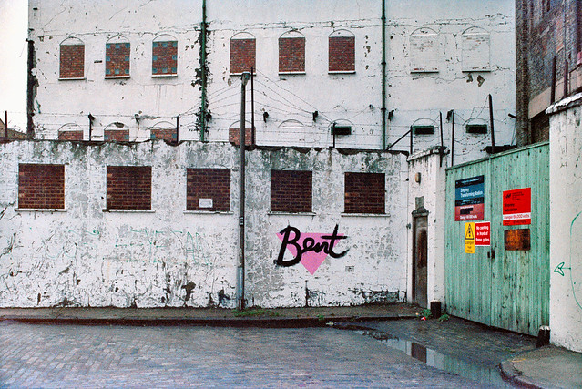
Limehouse and the City – Panoramas 1994: I made one panorama at the end of my trip to Limehouse in June which is on a film processed in July which I overlooked when posting pictures to Flickr.

DLR Viaduct, Limehouse, Tower Hamlets, 1994, 94-701-51

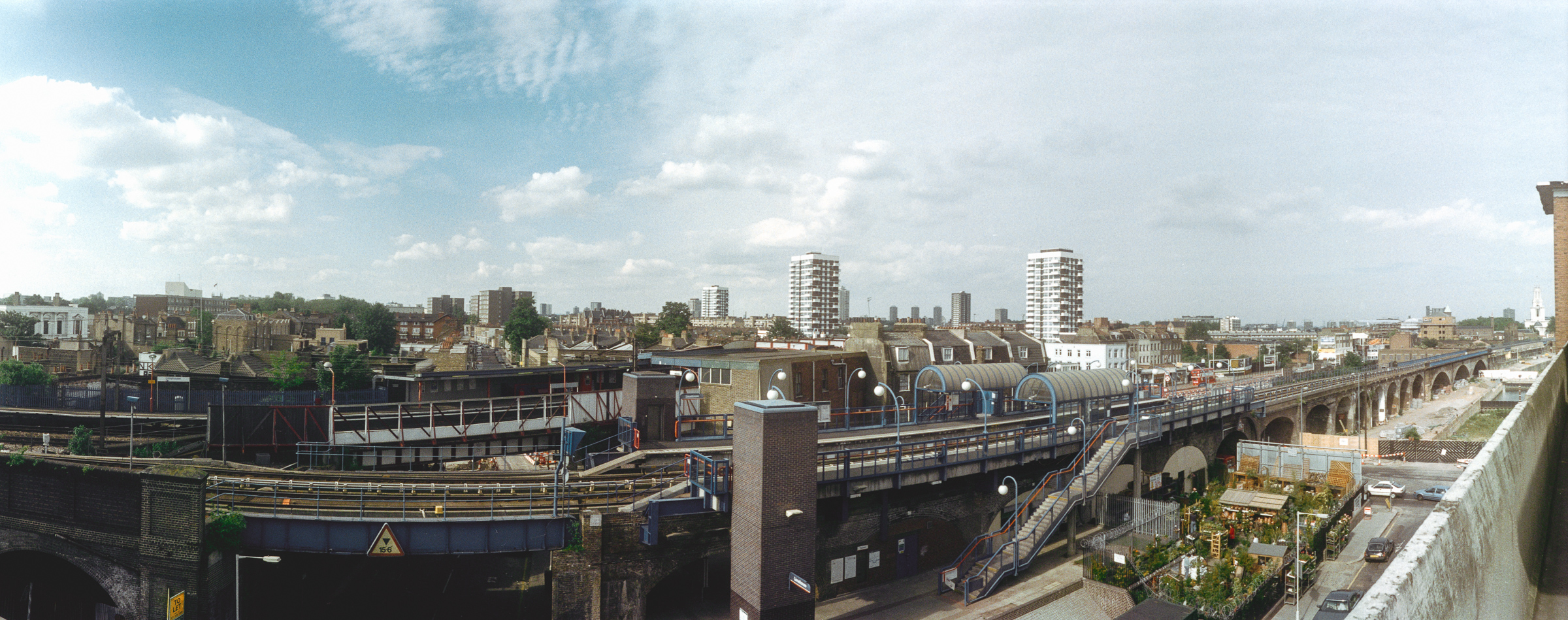
This was taken from the top floor of John Scurr House on Ratcliffe Lane where there are open balconies leading to the flats it shows both the National Rail and DLR Limehouse stations with the DLR viaduct leading east, with the white tower of St Anne’s Limehouse just visible at extreme right before the top of the brickwork of the stairs.

You can also just see the north side of Limehouse Basin on the other side of Branch Road, and lower right of centre is a small but packed garden centre. A bus goes along Commercial Road and you can see the houses and flats of Limehouse and Bow beyond. Like all the other pictures in this post it was taken with a swing-lens panoramic camera with a horizontal angle of view of over 120 degrees.

Blackfriars Rail Bridge, Blackfriars Bridge, River Thames, Southwark, 1994, 94-701-42

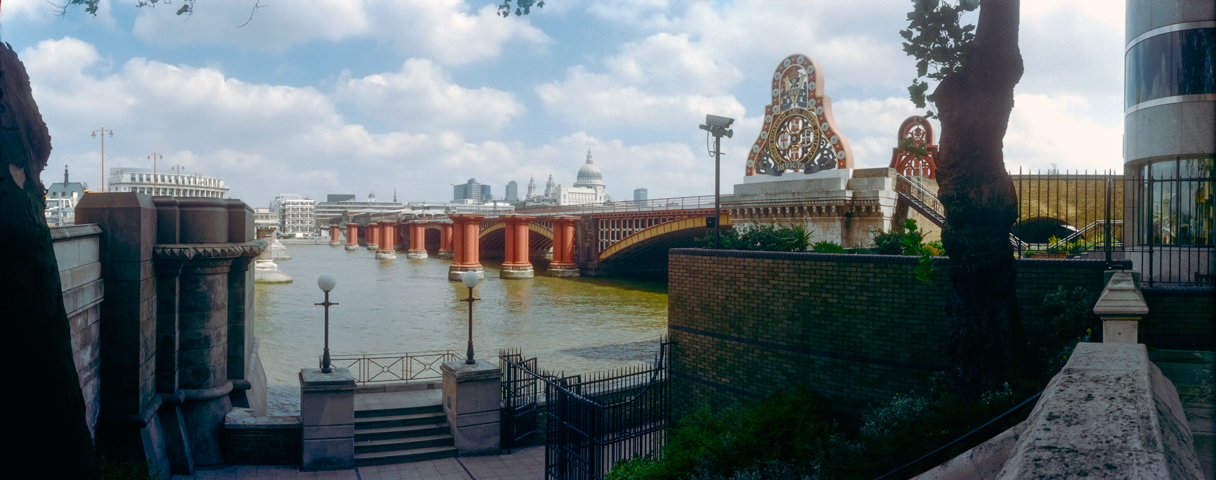
Early in July I took a train to Waterloo and walked into the City from there, pausing before I crossed Blackfriars Bridge to make this panorama. This is the only place where the City comes ‘South of the River’ and where I was standing in Rennie Garden I was already in the City of London, though the wall at right and half the rail bridge past it is in Southwark.

While the City boundary for the other bridges is in the centre of the river, for some reason the Blackfriars and Southwark Bridges Act 1867 put the full length and its southern end within the city’s borders, in the parish of St Anne Blackfriars.

The garden here Rennie Garden is named after John Rennie (1761 – 1821) the engineer who built several of London’s bridges but not this one, which was by by Joseph Cubitt, also responsible for the dismantled railway bridge whose red piers remain.

This was the site of the Albion Flour Mills designed by Samuel Wyatt on this site in 1786 to house the machinery of Matthew Boulton and steam engine of James Watt – and it was this steam-powered corn mill, the first major factory in London, which is thought to be the inspiration for William Blake’s ‘dark satanic mills’.

The Albion Mill died by its own hand, burnt down in 1791 by a fire probably caused by poor maintenance when a bearing overheated, but four years earlier Robert Barker had sent his son Henry Aston Barker to sit on the roof of the building to make the sketches for his ‘London from the roof of the Albion Mills‘ which he then added detail, “greatly enlarged and painted in distemper on canvas.” He coined the name ‘panorama’ and in 1787 patented the idea. His panorama, first shown at the Albion Mill shortly before it was burnt down and then shown in various galleries in London.

Sets of aquatints were made by Frederick Birnie which toured Europe and went to the United States and while these survive in various collections the original panorama is lost.

Puddle Dock, Queen Victoria St, City, 1994, 94-701-33

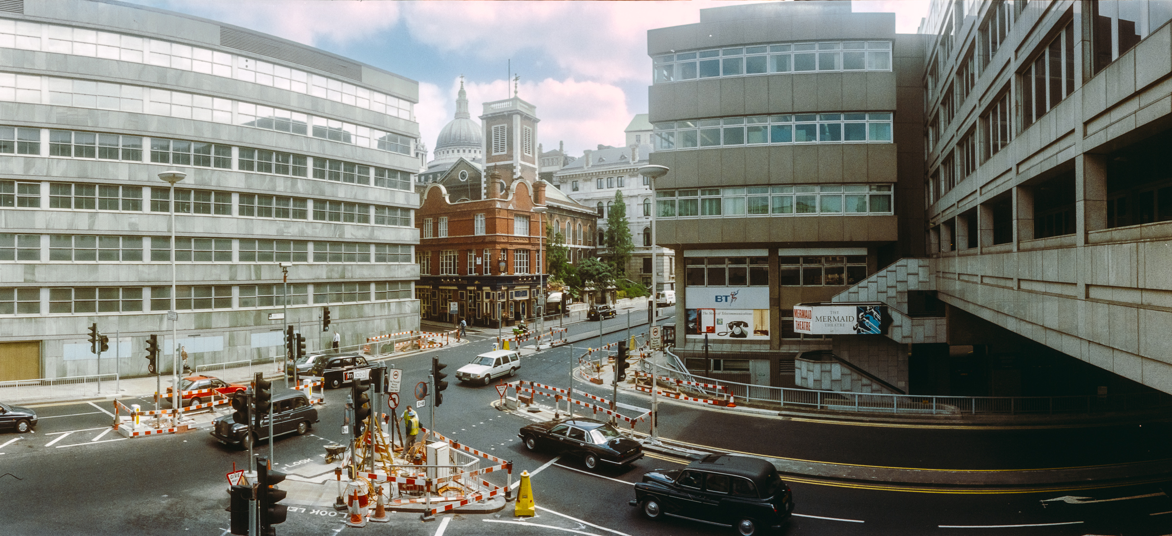
Puddle Dock was a dock and also a sewer outfall and was filled in during the comprehensive reclamation and redevelopment of the area between 1962 and 1972 which created Upper Thames Street as a major road and Puddle Dock linking this to Queen Victoria Street underneath part of Baynard House, a Brutalist office block built for BT and completed in 1979.

As a part of plans to separate vehicle and pedestrian movement in the City it included a walkway leading to Blackfriars Station from which I made this panorama. The dome of St Paul’s can be seen just to the left of the tower of St Andrew by the Wardrobe.

Sculpture, Farringdon Rd, Holborn Viaduct, City, 1994, 94-702-51

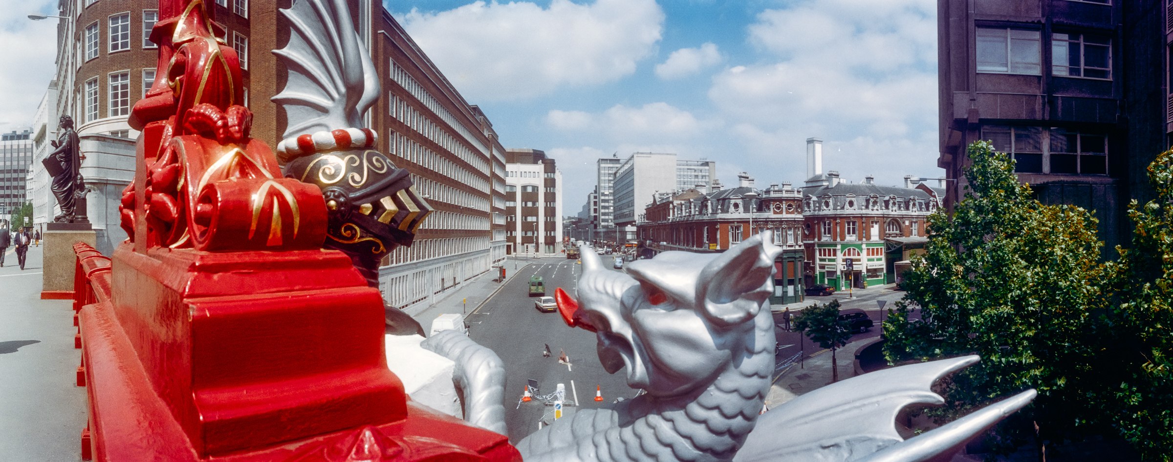
Holborn Viaduct was London’s first flyover, connecting the City with Holborn over the deep valley of the River Fleet, which had be culverted here in the 18th century, in part for the building of New Bridge Street. Built in 1863-69 it links Holborn Circus with Newgate Street and was a major redevelopment ‘”the most ambitious and costly improvement scheme of the [nineteenth] century” (White 47), and it involved some outstanding feats of Victorian engineering.

Over the years I’ve made quite a few panoramas on and of the viaduct and written about it at some length – here are a few from 1994. You can read a detailed account on the Victorian Web site.

Sculpture, Farringdon Rd, Holborn Viaduct, City, 1994, 94-702-52
Sculpture, Farringdon Rd, Holborn Viaduct, City, 1994, 94-703-11

More from July 1994 in the City later.


FlickrFacebookMy London DiaryHull PhotosLea ValleyParis
London’s Industrial HeritageLondon Photos

All photographs on this page are copyright © Peter Marshall.
Contact me to buy prints or licence to reproduce.


Limehouse, Poplar, Blackwall and East India Panoramas – 1994

Limehouse, Poplar, Blackwall and East India Panoramas: In June 1994 I took a walk east from Limehouse, making a new series of panoramic images as well as taking some more normal photographs. I think these images were taken on a couple of different walks, but here I’ll present them in a roughly geographical order, going east from Limehouse Basin to East India Dock Basin station and largely following the Docklands Light Railway.

Limehouse Dock, Limehouse, 1994, 94-62-32
Limehouse Dock, Limehouse, Tower Hamlets, 1994, 94-62-32

Limehouse Dock in 1994 was not surrounded by flats and there was a clear view from the the council flats – John Scurr House – on the corner of Ratcliffe Lane and Branch Road – which you can see at the right.

And in 1994, as in many such blocks, there was little or no entrance security so I could simply walk in and up the stairs to take pictures such as this. The DLR viaduct runs from the left side to St Anne’s Church and the marina is almost empty, while Canary Wharf Tower in the distance is twice the height of the buildings around it, but now is surrounded by other tall towers.

Bridge, Aspen Way, Poplar DLR, Poplar, Tower Hamlets, 1994, 94-65-62

The bridge that leads across Aspen Way from the West India Docks to Poplar DLR station at the extreme right of the picture. At left you can see the DLR line from West India Quay which crosses the road in a blue bridge to join the line from Limehouse.

This picture made a rather nice album cover for the 1998 album The Limehouse Link by Mucho Macho, particularly impressive on the 12″ vinyl where it is carried across both front and back – reproduced at 24 by 12 inches, considerably larger than the CD version.

As Darryl Sterdan’s 1999 review stated “No vocals are no problem for the British DJs on their auspicious debut release” and despite its cover it made little impact.

DLR, Canary Wharf, Blackwall, Tower Hamlets, 1994, 94-63-22

I’d taken photographs in earlier years around the building of the Beckton extension of the DLR and the Limehouse Link tunnel and both had caused major changes in the area. Among which was this rather convoluted footpath leading under the road and DLR south from Blackwall Station.

Bridge, Blackwall Tunnel Approach, Naval Row, Blackwall, Tower Hamlets, 1994, 94-63-62

Parts of the Grade II listed inscription on the Northern portal of the Blackwall tunnel, built in 1897 are hard to read in my picture, so here it is in full: ‘THIS TUNNEL CONSTRUCTED BY THE LONDON COUNTY COUNCIL WAS OPENED BY/ HRH THE PRINCE OF WALES K.C. ON BEHALF OF HER MAJESTY QUEEN VICTORIA ON 22nd MAY 1897 IN THE 60th YEAR OF HER REIGN/ SIR ALEX R. BINNIE ENGINEER’

I had to wait some time back in 1994 for a train to pass across on the DLR. Services now are usually more frequent.

Dock, DLR Station, East India, South Bromley, Tower Hamlets, 1994, 94-63-52

I wandered rather a long time around East India Dock station, using the bridge across Aspen Way to photograph on both sides of the road. Here I photographed the station across an area of water which has been created in a part of the area formerly occupied by the East India Dock (Import), though I think nothing original remains. So probably I should caption this ‘water feature’ rather than ‘dock’.

East India DLR Station, South Bromley, Tower Hamlets, 1994, 94-64-52

Framed at the centre of this image are two towers, Canary Wharf and the much closer tower in Naval Row of the mid 19th century Italianate East India Dock Pumping Station, Grade II listed and one of the few relics of that dock, along with some listed walls and steps and the areas of water. The two towers are a similar shape but actually very different in size and detail.

More pictures from these June walks later.


FlickrFacebookMy London DiaryHull PhotosLea ValleyParis
London’s Industrial HeritageLondon Photos

All photographs on this page are copyright © Peter Marshall.
Contact me to buy prints or licence to reproduce.


Limehouse Cut – 1990

The final post on walk in Limehouse on Sunday 6th January 1990 continued. The previous post from this walk is West India Dock Road & Limehouse Cut – 1990. As usual you can click on the images here to view larger versions on my Flickr pages.

Limehouse Cut, Railway viaduct, Limehouse, Tower Hamlets, 1990, 90-1c-12

Looking south towards the blockage across the canal through the bridge which carries the DLR over Limehouse Cut. At the right are the temporary buildings for the construction work on the Limehouse Link tunnel. The Limehouse Cut turns around to the right past the blockage to join Limehouse Dock and I think the industrial buildings you can see are in Brightlingsea Street.

Flood Barrier, Limehouse Cut, Limehouse, Tower Hamlets, 1990, 90-1c-15

I walked along the towpath to Commercial Road carried over the canal by Britannia Bridge, named for the Britannia Tavern which stood here until 1911, when it was probably removed to allow the bridge to be widened for traffic and also to allow for a towpath under the bridge.

At spring tides when the water rose to its highest it would overtop the old Bow Locks, with water flowing into both the Cut and the lower stretch of the Lea Navigation. This created a problem, particularly when the Cut was connected to the Limehouse Dock. In this picture you see the vertical guillotine gate which was fitted here after the Cut was taken over by British Waterways in 1948 enabling the canal to be isolated from the dock. It was removed soon after I made this picture.

You can also see the 1923 Empire Memorial Sailors’ Hostel on the corner of Commercial Road and Salmon Lane, built as a memorial to all the seamen who had lost their lives in the First World War. Later used as a hostel for the homeless and to house immigrants it had by 1990 been converted into luxury flats.

H W Bush, Mill Place, Limehouse, Tower Hamlets, 1990, 90-1c-16
Island Row, Mill Place, Limehouse, Tower Hamlets, 1990, 90-1f-66
Limehouse Basin, Northey St, Narrow St, Limehouse, Tower Hamlets, 1990, 90-1f-65

Taken from near to the end of Island Row. But my walk was coming to an end. I made only one more black and white picture, not yet digitised, of the Regents Canal Lock from Commercial Road on my way to Limehouse station.

But I had also carried a second camera body loaded with colour negative film and I made the occasional colour picture during the walk. Here are four of them:

Stepney Transforming Station, Brightlingsea Place, Limehouse, Tower Hamlets, 1990, 90c01-01-73
Poplar Fish Bar, Poplar, Tower Hamlets, 1990, 90c01-01-62
Everite Autos, Poplar, Tower Hamlets, 1990, 90c01-01-64
Everite Autos Mill Place, Limehouse, Tower Hamlets, 1990, 90c01-01-64
Café, Poplar, Tower Hamlets, 1990, 90c01-01-52

FlickrFacebookMy London DiaryHull PhotosLea ValleyParis
London’s Industrial HeritageLondon Photos

All photographs on this page are copyright © Peter Marshall.
Contact me to buy prints or licence to reproduce.