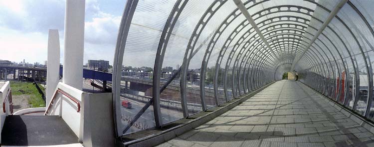
Limehouse, Poplar, Blackwall and East India Panoramas – 1994

Limehouse, Poplar, Blackwall and East India Panoramas: In June 1994 I took a walk east from Limehouse, making a new series of panoramic images as well as taking some more normal photographs. I think these images were taken on a couple of different walks, but here I’ll present them in a roughly geographical order, going east from Limehouse Basin to East India Dock Basin station and largely following the Docklands Light Railway.

Limehouse Dock, Limehouse, 1994, 94-62-32
Limehouse Dock, Limehouse, Tower Hamlets, 1994, 94-62-32

Limehouse Dock in 1994 was not surrounded by flats and there was a clear view from the the council flats – John Scurr House – on the corner of Ratcliffe Lane and Branch Road – which you can see at the right.

And in 1994, as in many such blocks, there was little or no entrance security so I could simply walk in and up the stairs to take pictures such as this. The DLR viaduct runs from the left side to St Anne’s Church and the marina is almost empty, while Canary Wharf Tower in the distance is twice the height of the buildings around it, but now is surrounded by other tall towers.

Bridge, Aspen Way, Poplar DLR, Poplar, Tower Hamlets, 1994, 94-65-62

The bridge that leads across Aspen Way from the West India Docks to Poplar DLR station at the extreme right of the picture. At left you can see the DLR line from West India Quay which crosses the road in a blue bridge to join the line from Limehouse.

This picture made a rather nice album cover for the 1998 album The Limehouse Link by Mucho Macho, particularly impressive on the 12″ vinyl where it is carried across both front and back – reproduced at 24 by 12 inches, considerably larger than the CD version.

As Darryl Sterdan’s 1999 review stated “No vocals are no problem for the British DJs on their auspicious debut release” and despite its cover it made little impact.

DLR, Canary Wharf, Blackwall, Tower Hamlets, 1994, 94-63-22

I’d taken photographs in earlier years around the building of the Beckton extension of the DLR and the Limehouse Link tunnel and both had caused major changes in the area. Among which was this rather convoluted footpath leading under the road and DLR south from Blackwall Station.

Bridge, Blackwall Tunnel Approach, Naval Row, Blackwall, Tower Hamlets, 1994, 94-63-62

Parts of the Grade II listed inscription on the Northern portal of the Blackwall tunnel, built in 1897 are hard to read in my picture, so here it is in full: ‘THIS TUNNEL CONSTRUCTED BY THE LONDON COUNTY COUNCIL WAS OPENED BY/ HRH THE PRINCE OF WALES K.C. ON BEHALF OF HER MAJESTY QUEEN VICTORIA ON 22nd MAY 1897 IN THE 60th YEAR OF HER REIGN/ SIR ALEX R. BINNIE ENGINEER’

I had to wait some time back in 1994 for a train to pass across on the DLR. Services now are usually more frequent.

Dock, DLR Station, East India, South Bromley, Tower Hamlets, 1994, 94-63-52

I wandered rather a long time around East India Dock station, using the bridge across Aspen Way to photograph on both sides of the road. Here I photographed the station across an area of water which has been created in a part of the area formerly occupied by the East India Dock (Import), though I think nothing original remains. So probably I should caption this ‘water feature’ rather than ‘dock’.

East India DLR Station, South Bromley, Tower Hamlets, 1994, 94-64-52

Framed at the centre of this image are two towers, Canary Wharf and the much closer tower in Naval Row of the mid 19th century Italianate East India Dock Pumping Station, Grade II listed and one of the few relics of that dock, along with some listed walls and steps and the areas of water. The two towers are a similar shape but actually very different in size and detail.

More pictures from these June walks later.


FlickrFacebookMy London DiaryHull PhotosLea ValleyParis
London’s Industrial HeritageLondon Photos

All photographs on this page are copyright © Peter Marshall.
Contact me to buy prints or licence to reproduce.


West India Dock Road & Limehouse Cut – 1990

West India Dock Road & Limehouse Cut: My walk in Limehouse on Sunday 6th January 1990 continued. The previous post from this walk is Garford Street Limehouse – 1990. As usual you can click on the images here (except the panorama) to view larger versions on my Flickr pages.

Shops, West India Dock Road, Limehouse, Tower Hamlets, 1990, 90-1c-42

This area is close to the parish border of Limehouse and Poplar, but in popular imagination was certainly Limehouse, London’s first ‘Chinatown’. But by 1990 Chinatown had almost entirely moved to Soho, though a few elements remained, including the Peking Restaurant – though a few shops down the street is the Poplar Fish Bar.

Davey & Co, 88, West India Dock Road, Limehouse, Tower Hamlets, 1990, 90-1c-43

“In February 1885 Arthur Christopher Davey began a venture that throughout the 20th century evolved into a culture in the manufacture and supply of marine equipment. From humble beginnings in Leadenhall Street, the company soon moved to its famous address at 88, West India Dock Road, London E14, where it successfully traded for over 100 years.” The company is now based in Colchester.

Shops, West India Dock Road, Limehouse, Tower Hamlets, 1990, 90-1c-45

The Wah Ying Restaurant was another remanant of Chinatown – and you can see along the road the sign of the Peking Restaurant. In the distance are the warehouses of the West India Docks and beyond them the cranes building Cabot Square at Canary Wharf.

West India Dock Road was laid out at the same time as the West India Docks opened in 1802, a new road to give access to them, which was for many years a toll road. I think these buildings probably date from the 1870s or a little later after the tolls were removed.

The restaurant looks very much closed and the broken windows above suggest it was empty and derelict when I made this picture.

Blockage, Limehouse Cut, Limehouse, Tower Hamlets, 1990, 90-1c-46

The Limehouse Cut runs on a straight route through Poplar but curves around at its southern end. It was blocked here in 1990, possibly in connection with the building of the Limehouse Link tunnel between 1989 and 1993. But there was also work on the Cut around then, with the vertical guillotine gate on the north side of Britannia Bridge across the Commercial Road being removed.

Poplar Mods, graffiti, Railway Viaduct, St Anne's Church, Limehouse, Tower Hamlets, 1990, 90-1c-32
Poplar Mods, graffiti, Railway Viaduct, St Anne’s Church, Limehouse, Tower Hamlets, 1990, 90-1c-32

The tower of Hawksmoor’s St Annes Limeouse seen above the viaduct built for the London and Blackwall Railway and opened in July 1840, the second or third railway viaduct to be built in London, after the 1836 London to Greenwich viaduct and the the Hanwell viaduct, technically then outside London. The line went to Brunswick Wharf in Blackwall where passengers could board ferries and boats to other destinations down river or around the world.

I can tell you nothing more about Poplar Mods except that the graffiti tells us they are male “Hammers” fans. West Ham began life as a team for the workers of the last remaining shipbuilders in the area not far away on Bow Creek as the Thames Ironworks Football Club. From 1895 they played at Hermit Road in Canning Town, former home to Old Castle Swifts, Essex’s first professional team which had gone bankrupt, They became West Ham United in 1900 and moved to Plaistow, before in 2004 uniting with the Boleyn Castle football club and moving to their Upton Park ground where they stayed until 2016.

Limehouse Cut, Railway viaduct, Limehouse, Tower Hamlets, 1990, 90-1c-21

I think the next few pictures I made were taken from the block of flats immediately to the east of Limehouse Cut, Kiln Court, a medium rise block built as part of the Barley Mow Estate for the GLC in 1965-8. Back in 1990 many blocks still did not have security doors and it was possible to easily access shared areas.

Here you can see the Cut and the DLR viaduct across the north side of Limehouse Dock with its bridge and the Roman Catholic Church of Our Lady Immaculate & St Frederick on the corner of Island Row and Commercial Road.

I think the buildings on the far bank of Limehouse Cut were temporary offices and accommodation for the building of the Limehouse Link tunnel. The site is now occupied by housing at the end of Island Row.

Limehouse Cut, Limehouse Dock, Railway viaduct, Limehouse, Tower Hamlets, 1990, 90-1c-23

In this picture you can see across to Limehouse Dock with the Hydraulic Accumulator Tower next to the DLR viaduct at the right. At the left is the temporary blockage on the Limehouse Link.

Limehouse Cut, Limehouse Dock, Railway viaduct, Limehouse, Tower Hamlets, 1990, 90-1c-24

Sliding my shift lens to the left gave a view a little further towards the south and shows a little more of the Cut past the blockage and in the distance a small glimpse of the River Thames. This image was taken to create a panorama together with 90-1c-23:

Limehouse Cut, Limehouse Dock, Railway viaduct, Limehouse, Tower Hamlets, 1990, 90-1c-23-24

More from Limehouse Cut in the next post on this walk.


FlickrFacebookMy London DiaryHull PhotosLea ValleyParis
London’s Industrial HeritageLondon Photos

All photographs on this page are copyright © Peter Marshall.
Contact me to buy prints or licence to reproduce.


Church, Pyramid, Star of the East – More Limehouse

St Anne's Church, Limehouse, Tower Hamlets, 1988 88-7o-32-positive_2400
St Anne’s Church, Limehouse, Tower Hamlets, 1988 88-7o-32

Church, Pyramid, Star of the East – More Limehouse
My walk around Limehouse came back to the area I think of as its heart, close to St Anne’s Church, one of the Queen Anne Churches built after the 1711 Act of Parliament and consecrated in 1730. St Anne’s is one of the six London churches by Nicholas Hawksmoor along with St Alfege’s Greenwich, St George’ Bloomsbury, Christ Church, Spitalfields, St George in the East Wapping andhis only church in the City of London, St Mary Woolnoth.


St Anne's Churchyard, St Anne's Passage, Limehouse, Tower Hamlets, 1988  88-7o-34-positive_2400
St Anne’s Churchyard, St Anne’s Passage, Limehouse, Tower Hamlets, 1988 88-7o-34

I turned my back on the church to photograph the entrance gate to the churchyard.

Limehouse Pyramid, St Anne's Church, Limehouse, Tower Hamlets, 1988  88-7o-36-positive_2400
Limehouse Pyramid, St Anne’s Church, Limehouse, Tower Hamlets, 1988 88-7o-36

The church has featured in many books and publications, including the work of psychogeographers and other more esoteric and mystical writers, and seems to have a special place in the works of believers in ley lines. I’ve not read or seen the film ‘Dark Lines Of London’, but a web page claims to give “Factual Information That Provides the Backdrop to the Story” and includes descriptions and photographs of 10 sites, all from centuries after that in which the story is set, along “a real ley line” one of which is this “Wisdom Of Solomon” Pyramid.

Princes Lodge, Commercial Rd, Limehouse, Tower Hamlets, 1988  88-7o-22-positive_2400
Princes Lodge, Commercial Rd, Limehouse, Tower Hamlets, 1988 88-7o-22

THE 4TH CONFERENCE of the Situationist International was held in London, at a secret address in the East End, 24-28 September 1960, seventeen months after the Munich Conference (April 1959). The situationists assembled in London were: Debord, Jacqueline de Jong, Jorn, Kotányi, Katja Lindell, Jörgen Nash, Prem, Sturm, Maurice Wyckaert and H.P. Zimmer. In fact, to ensure that the proceedings were kept well away from any contact with London journalists or artistic circles, the conference took place at the British Sailors Society hall in Limehouse, “an area famous for its criminals”.

Internationale Situationniste #5

Star of the East, Commercial Rd, Limehouse, Tower Hamlets, 1988  88-7o-23-positive_2400
Star of the East, Commercial Rd, Limehouse, Tower Hamlets, 1988 88-7o-23

Built in the early 19th century and Grade II listed the Star of the East was serving beer at least from 1845. More recently the building had deteriorated and closed as a pub around 2010, was reopened a couple of years later but closed again in 2016. The pub was then taken over and refurbished by the Old Spot Pub Co, who run around a dozen pubs re-opening again in 2019.

Star of the East, Commercial Rd, Limehouse, Tower Hamlets, 1988  88-7o-11-positive_2400
Star of the East, Commercial Rd, Limehouse, Tower Hamlets, 1988 88-7o-11

You can read more about its recent transformation and see some photographs from London Pub Explorer. I’ve yet to return to see for myself. Back in 1988 part of the building was a separate restaurant, but I think the pub now occupies the whole building. The refurbishment appears to have kept at least some of the original interior features.

Bate St, Three Colt St, Limehouse, Tower Hamlets, 1988  88-7o-14-positive_2400
Three Colt St, Limehouse, Tower Hamlets, 1988 88-7o-14

Three Colt St, which has St Anne’s Church at its northern end is one of the oldest roads in the area, part of the route from Limehouse to Stepney and first recorded in 1362. In the Victorian era it was flanked by a number of shops and was something of a middle-class enclave surrounded on both sides by extreme poverty. Little remains from those times. The building here is the former London and Blackwall Railway station, probably dating from the opening of the railway in 1840. The station closed in 1926, but the line remained in use for goods traffic until the 1960s. When the line was reused for the Docklands Light Railway in 1987, Westferry station was built around 300 yards to the east.

Emmett St, Limehouse, Tower Hamlets, 1988 88-7o-16-positive_2400
Emmett St, Limehouse, Tower Hamlets, 1988 88-7o-16

Not only this building but the street that it was in have disappeared since I made this picture. Emmett St was at the end of Three Colt St, roughly where the Limehouse Link tunnel entrance is now. Construction of the tunnel began in November 1989 and the project was officially opened in May 1993, at £293,000,000 the most expensive per mile road scheme ever built in the UK, a huge public subsidy to the Canary Wharf redevelopment.

When Mucho Macho released ‘The Limehouse Link’ in 1998 it had one of my pictures wrapped around both the CD and the 12″ LP, where it looked rather more impressive. But this image was from Poplar – and this is the full image from the Urban Landscapes web site and doesn’t show the Limehouse Link at all.


Clicking on any of the black and white images above will take you to a larger version in my 1988 London Photos from where you can browse the album.