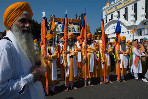
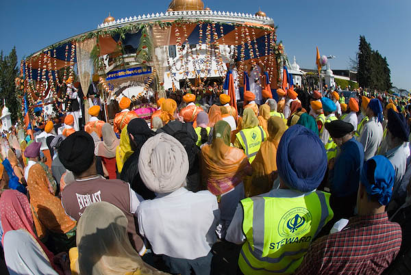
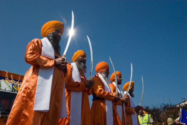
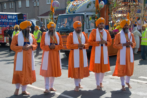
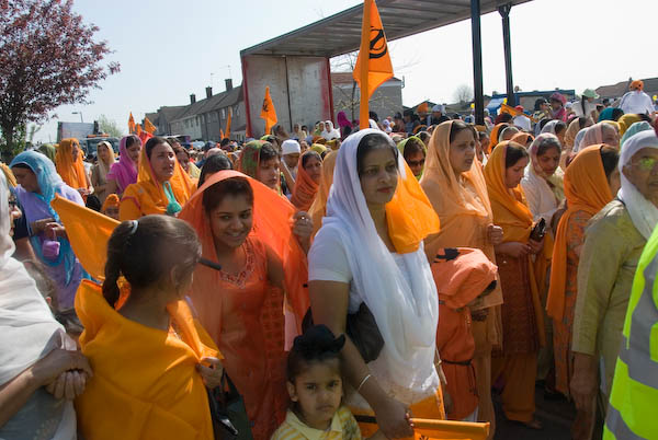
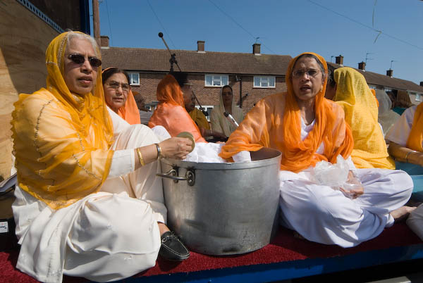
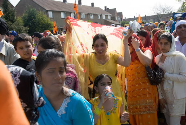
Vaisakhi Procession, Slough: On Sunday 15 April, 2007 I decided at the last minute to rush to Slough, picked up my rumāl and arrived just in time to photograph the Vaisakhi Procession as it left the Gurdwara. Two years later in 2009 I returned and was able to cover it more thoroughly and you can see the results on My London Diary – but in this post I’ll stay with the pictures and text from 2007. As usual I’ve made the text easier to read, correcting the capitalisation and typos etc.
Vaisakhi in Slough
Slough, Berkshire
I’d hoped to relax a bit on Sunday, have a day off from working with a camera, catch up with things. But Linda heard something on the radio about Vaisakhi in Slough, so I looked on the web, found the procession started at 10.30 and jumped on my ancient bike.
By then it was 10.15am, and according to the AA, the 9.5 miles should have taken me 27 minutes by car (and you could probably add a bit for parking etc onto that.)
So 40 minutes wasn’t too bad going, and I arrived just before the procession started to move off, just before 11.00am.
By the time I left two hours later, the procession carrying the Sikh holy scriptures and led as always by Khalsa carrying flags and swords was just around the corner a couple of hundred yards away in Shaggy Calf Lane (though it had taken a rather longer route than me to get there.) And as well as photographing the event and many of those taking part, I’d also had a very enjoyable free lunch.
I made my way home rather more slowly. One of the great advantages of travelling by bike is that you can stop exactly where you like to take photos.
As well as a few buildings in Slough, and what remains of a landmark garage at the west end of the Colnbrook Bypass (now sold and doubtless to be redeveloped) I spent some time in Horton, which in my youth really was a country village, and still retains some of that feeling, before returning to Staines via Wraysbury.
Garford Street Limehouse: My walk in Limehouse on Sunday 6th January 1990 continued. The previous post from this walk is Around Emmett Street, Limehouse 1990. As usual you can click on the images here to view larger versions on my Flickr pages.
Garford Street is variously described as in Limehouse, Westferry and Poplar, although estate agents seem to prefer Canary Wharf, which is certainly isn’t, though fairly close by. Back in 1990 I think most of us thought it was Limehouse.
The 1994 LCC Survey of London deals with it in a chapter Limehouse Hole: The inland area. This tells us that a John Garford in the early 19th century had a wharf on the Thames at its western end on Emmett Street. Since the building of the Limehouse Link tunnel and the new route of Westferry Road for the Canary Wharf redevelopment it now starts around 200 yards to the east on Westferry Road. Its other end is still at the West India Dock Road.
I think the junction here is a part of the lost area on the north side of Garford Street. The chimney in the background is a remnant of the Lion Works, established here in “1896-7 by James Walker & Company, steam packing makers,” later Lion Packings Ltd who made “Patent metallic packing” here until around 1926. “The site was cleared for public housing in 1938–9” but as you can see the chimney survived until 1990.
Another view just a few yards from the previous image shows some large cable drums from AEI Gravesend. A notice tells those waiting for MOT tests at the Austin Rover garage where to queue.
This derelict warehouse building still has the remains of a hoist to the first floor entrance above its main door. There is now new housing on this site just to the west of the DLR railway bridge on the north side of the street.
Greig House, Garford St, Limehouse, Tower Hamlets, 1990, Built 1902-3 as accommodation for officers from Scandinavian ships docked in London it was taken over in 1930 as a Salvation Army hostel, and later used to house male alcoholics and more recently as a residential detoxification centre for men and women with drug or alcohol problems. Grade II listed along with the cottages on Garford St.
A second view of Greig House which shows some of the buildings of the West India Dock on Hertsmere Road in the background as well as the cranes building parts of Canary Wharf around Cabot Square. You can read much more about this and the associated buildings on the Lost Hospitals of London site.
From here I walked across the West India Dock Road in Poplar where my next post on this walk will begin.
More from Narrow Street – 1990: My walk in Limehouse on Sunday 6th January 1990 continued. The previous post from this walk is Around Narrow Street, Limehouse – 1990
It was hard not to take picture after picture on Narrow Street, particularly as I was aware much was soon to disappear, and I made over 20 exposures, though I’ve digitised less than half of these, and I’ll only post a few of these as some of the others are rather similar or at least overlap in terms of subject. This view shows some of the same buildings from the picture that ended the previous post, but from a slightly different viewpoint. Most including all in this view ,were demolished shortly afterwards.
My previous post told the story of Duncan Dunbar and his son of the same name who built up a huge shipping empire based around Dunbar Wharf but sold off at his death in 1862. The four warehouses at 136, 136½, 138, 140 were Grade II listed in 1973 and some at least were still in various commercial use back in 1990.
Until the 1970s it was a working wharf – E W Taylor, a lighterage company had begun using it for oversize cargo in 1857 – and the company also “became experts in the warehousing and fumigation of the botanicals used in making gin.” The company, now part of Dunbar Wharf Holdings Limited, acquired Dunbar Wharf in the 1940s.
All the remaining properties in Dunbar Wharf have now been converted into flats and you can read online about the 2020 renovation of one of the 1790s warehouse buildings into “a beautiful residence by the Thames.”
Barlow and Sons Auto Repairs were at 144 Narrow Street and offered their auto repairs with the aid of some really king-size spanners. This building was replaced in 1997 by Creek House.
These buildings were demolished shortly after I made these photographs for the development of the Limehouse Link tunnel and were then replaced by modern flats with a vaguely pastiche frontage. Their demolition enabled archaeological investigation of the site of Joseph Wilson and Company’s Limehouse Porcelain Manufactory operating here from 1745-8.
St Dunstan’s Wharf, Narrow St, Limehouse, Tower Hamlets, 1990, 90-1b-44
St Dunstan’s Wharf at 142 Narrow Street is also Grade II listed and has survived. Together with the listed buildings of Dunbar Wharf it backs onto Limekiln Dock. Above the doorway is its name and a floral decoration together with what appears to be a large pair of blacksmiths’ tongs, the pincers used by St Dunstan to grab the together with another tool I don’t recognise.
Along is bottom are the initials W & G.G and the date 1878. Gardner & Gardner, hay & straw salesmen, are listed at this address as well as in Spread Eagle Yard in Whitechapel High Street. The listing text states this is on a metal plate, but it looks more like terracotta in my picture. Apparently the building was also used as a store for materials including juniper berries and flowers used to make gin.
I was more or less at the end of Narrow Street and my walk will continue along Three Colt Street in another post.
I’m not sure which of the nine eleven-story slab blocks on the estate is shown in my picture; the estate was and remains a rather confusing area. Possibly this is Leicester House on Loughborough Road, or more likely Harpur House on Angell Road where I think I walked to next, but the lower buildings in front of the block appear to have gone.
The sign ‘NO HATS’ is not a reference to any headgear but to Housing Action Trusts, an important part of Margaret Thatcher’s marginalisation of local authorities. Having ochestrated the run-down of council estates by earlier restrictions on council spending and the right to buy schemes, the Housing Act 1988 aimed to transfer these estates to non-departmental public bodies which were to redevelop or renovate them so they could be transferred into private ownership.
Opposition to HATs was intense, with the Labour Part, local authorities and estate residents all fighting their imposition, and the first six areas intended to becom HATs managed to avoid implementation, though later six were formed, but none in south London.
I think this rather temporary-looking building as on Angell Road close to Harpur House, but no sign of it remains. I photographed it largely for the posters showing opposition to Housing Action Trusts in Broxton.
As well as a Luncheon Club for pensioners it also has a sign for the Loughborough Sports & Social Club.
Fence, St John the Evangelist, Angell Park Gardens, Angell Town, Lambeth, 1989 89-5d-32
Further along Angell Road – named like the area after the Angell family who had owned large parts of the Lambeth and developed this area in the 1850s. In 1852 Benedict John Angell gave a site here for the building of St John the Evangelist Church which was consecrated in 1853. Unfortunately trees along the edge of the site along Angell Road and Angell Park Gardens had too many leaves in May to clearly see the church.
These paintings on the fence around the church are still visible but rather faded. I took a few pictures of them both in black and white and in colour before walking on past the church and across Wiltshire Road into Villa Road and back onto Brixton Road, where I photographed the rather austere Our Lady of the Rosary Catholic Church (not yet digitised.)
Abeng Youth Community Centre, Gresham Rd, Brixton, Lambeth, 1989 89-5d-22
I walked on down Brixton Road to the Police Station where I turned back east along Gresham Road, stopping to photograph what looked to me to be a former chapel. In 1877 this was the Angell Town Institution and later became Brixtons first telephone exchange.
In the 1970s the Rev Tony Ottey founded the Abeng Centre here to provide supplementary education and youth services to the local children. In 2003 it was relaunched with new management as the Karibu Centre, its Swahili name Karibu meaning welcome, with similar aims. It is also hired for weddings, funerals, birthdays and business meetings.
Soon I was walking through the Loughborough Estate again, going along Millbrook Road and through Wyck Gardens, a public open space which is thought to be the remnant of a larger wood knwon as Wickwood in the Manor of Lambeth Wick which had been cleared by the end of the 17th century.
The land had belonged to the Archbishops of Canterbury and was bought by the London County Council from the Church Commissioners for a new public open space, opened in 1959 and since extended and improved. You can see more pictures from the park on Brixton Buzz.
I think the large block here is Barrington Court, the first of three I walked past on my way through the park towards Loughborough Junction.
I left the park and walked along Ridgeway Rd, beside the railway line from Brixton which curves around to a junction just north of Loughborough Junction Station. The next station on this line is at Elephant & Castle.
Some extensive work seems to be in progress on what I am reliably informed (thanks to comments on Flickr) is a Ford Escort, while inside the garage a Renault 4 and a Rover P5 await their turn.
Arch 500 was empty for some years but later became home to the very Brixton Buzwakk Records Recording Studio a few years ago. The arches on both sides are still garages.
The Tropical Palace Theatre in Chamberlayne Road, close to the junction with Kilburn Lane was in the 1980s a major reggae venue. It had begun as The Acme Picture Theatre in October 1913, but with a change of management became Kings Picture Palace three months later. In 1931 a new company greatly enlarged and remodelled the building in an Art Deco style with architects John Stanley Beard and A. Douglas Clare and decorative work by by W.R. Bennett to seat 1600 – over 5 times its original capacity – with the old theatre forming the foyer of the renamed ‘New Palace Theatre’, and the rear of the building stretched to Kilburn Lane. Taken over by ABC in 1935 it became simply the Palace Theatre, and in 1970 it became the ABC and was converted into a bingo hall in 1974, but closed soon after to become a nightclub. It was completely demolished and replaced by housing shortly after I made this picture. The building on the left has also been replaced, but Chamberlayne Mansions at right are still there
The distinctive frontages of the shops at the extreme right of this picture enable me to positively identify this washing machine advert as being on the side of the shop on the corner of Felixstowe Rd and Harrow Road in College Park at the west of Kensal Green, close to St Mary’s Cemetery.
Kensal Green Cemetery Works, 758 Harrow Rd, Brent, 1988
Kensal Green Cemetery, which is immediately to the east of St Mary’s Cemetery is rather better known and is worth visiting for some of its fine Victorian monuments. There are plenty to choose from, with over 65,000 burials there since the cemetery was opened in 1833 by the The General Cemetery Company, who were inspired by Paris’s Père Lachaise Cemetery. The Grade I listed cemetery is still in use and well worth a visit and there are often guided tours – and on another occasion I visited the catacombs
Gate, Kensal Green Cemetery, Harrow Rd, Kensington & Chelsea, 1988
Three London Boroughs meet around here, and Kensal Green Cemetery and its gates are in Kensington & Chelsea, while the opposite side of the road is in Brent, and the neighbouring Roman Catholic St Mary’s is in Hammersmith & Fulham. Kensal Green. Kensal Green was the first of London’s ‘Magnificent Seven’ private cemeteries around the city’s then outskirts and was, as Wikipedia points out, ‘immortalised in the lines of G. K. Chesterton’s poem “The Rolling English Road” from his book The Flying Inn: “For there is good news yet to hear and fine things to be seen; Before we go to Paradise by way of Kensal Green.” ‘Paradise by way of Kensal Green’ is now the name of a pub on Kilburn Lane.
J S Farley, Kensal Green Cemetery Works, 758 Harrow Rd, Brent, 1988
I don’t know what proportion of the monuments in Kensal Green Cemetery were produced in these works opposite the entrance gates, and set up in the same year, but they works now been demolished and replaced. There is still another monumental masons just a short walk away.
Waldo Rd, College Park, Hammersmith & Fulham, 1988
Further west along the Harrow Rd just before Scrubs Lane was a small industrial area in Waldo Rd and Trenmar Gardens. Rather to my surprise this small industrial building and its similar neighbour at Waldo Works have survived, though I think some of the area behind is now housing.
Trenmar Gardens, Waldo Rd, College Park, Hammersmith & Fulham, 1988
The large garage at the left of the picture has been demolished and replaced by housing.
Trenmar Gardens, College Park, Hammersmith & Fulham, 1988
Trenmar Gardens, College Park, Hammersmith & Fulham, 1988
All of these pictures (and a few more) are from my Flickr album 1988 London Photos and were taken in March 1988. Clicking on any of the images will open a larger version in the album from where you can browse forwards or backward in the album.
All photographs on this and my other sites, unless otherwise stated, are taken by and copyright of Peter Marshall, and are available for reproduction or can be bought as prints.