Posts Tagged ‘Brixton Buzz’

Fighting Brixton Gentrification – 2015

Thursday, April 25th, 2024

Fighting Brixton Gentrification – On Saturday 25th April 2015 the local community in Brixton held a day of activities to reclaim its social & cultural diversity, threatened by increasing rents and property development that are forcing out local businesses and residents.

Fighting Brixton Gentrification

I’d arrived early for main ‘Reclaim Brixton’ event in Windrush Square and first made my way to Atlantic Road where long-established local businesses were being forced out from the railway arches which line one side of the road. They were under threat from Network Rail who with support from Lambeth Council were carrying out a refurbishment programme which would result in their shops being closed and the rents for the shops after being three times as high, pricing the low cost local businesses out of the area.

Fighting Brixton Gentrification

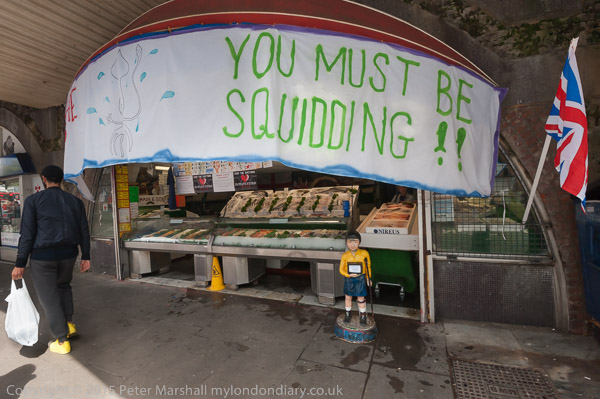
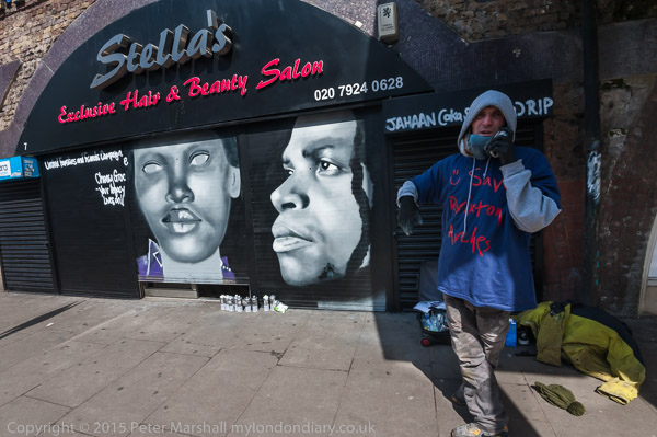
All the stores were closed for two hours across lunchtime in protest, and mural artists had been invited to work on their metal shutters. In 2015 I wrote: ‘On Stella’s Exclusive Hair & Beauty Salon an artist was working on a mural for the United Families and Friends campaign, celebrating Cherry Groce, Sean Rigg and Ricky Bishop, all killed by Brixton police. All the shops on both sides of the arches were closed, and most had white sheets with the name of the business and a punning message about the evictions. Some of them have traded here for many years – Denmay Fabrics since 1948, and L S Mash and Sons have been fishmongers here since 1932. Their message to Network Rail – ‘Don’t rip the soul outta my place

Fighting Brixton Gentrification

Fighting Brixton Gentrification

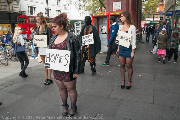
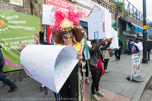
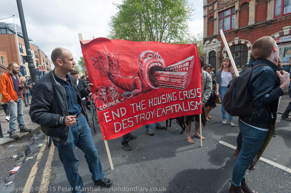
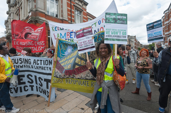
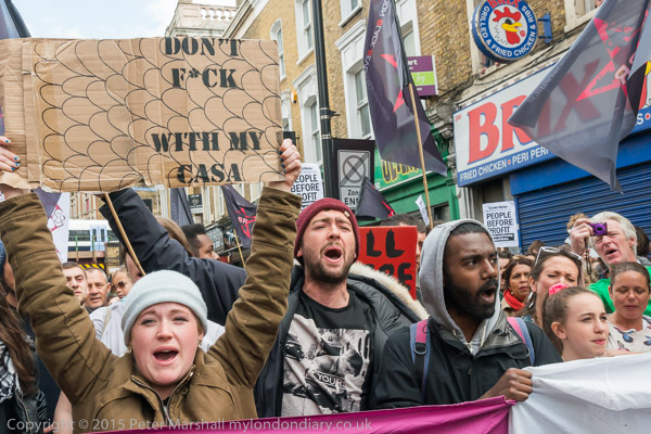
Street theatre groups walked past on their way to ‘Reclaim Brixton’ some in exotic dress carrying cardboard homes and others with posters against the threat to Communities, Homes, Businesses from Lambeth Council.

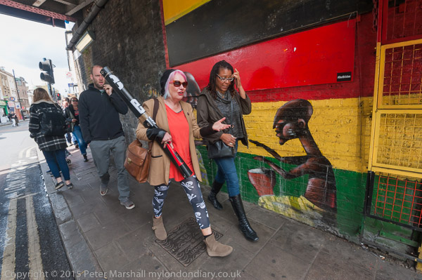
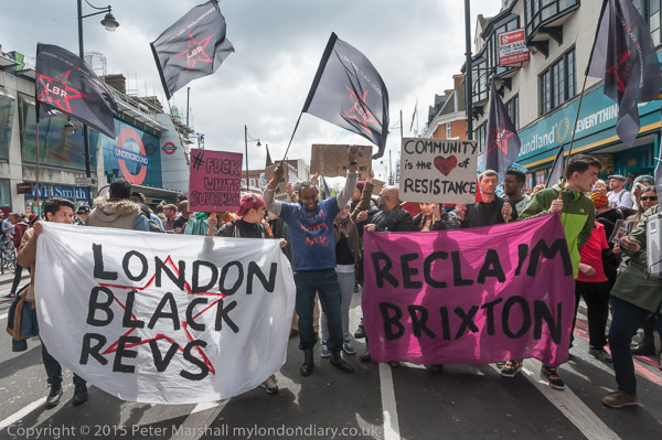
I walked along to the gentrified Brixton Village, an extensive arcade between Atlantic Road and Coldharbour Lane, to find that police and security were keeping out protesters who, led by London Black Revs, had planned to go through the market in a peaceful march.

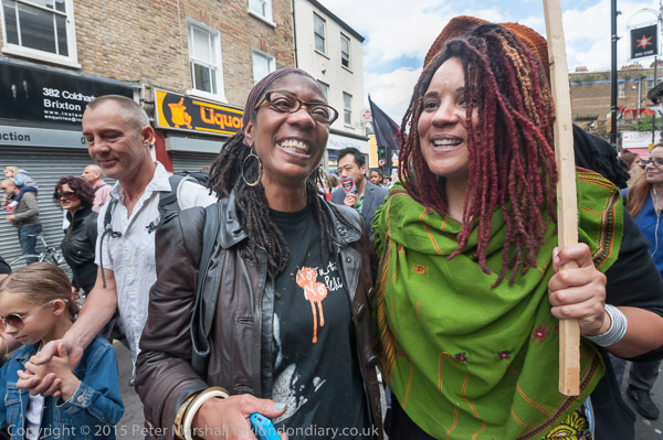
I found Class War at Brixton Station and walked back with them to Brixton Village, where other campaigners including some from the Ayslesbury Estate where I had photographed the previous day making their banner and other South London housing campaigners were arriving for the march.

Rather to my surprise the march when it finally started was a short and fairly direct one to Windrush Square, turning off Coldharbour Lane to enter the square via Rushcroft Road.

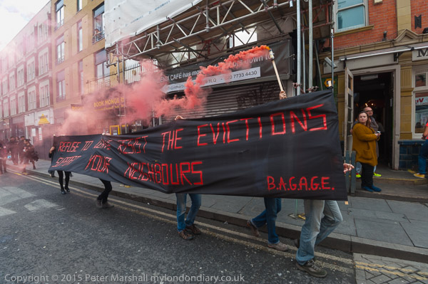
Close to the mansion flats which had been squatted for 32 years before residents were violently evicted in July 2013 people accompanying the long black banner of B.A.G.A.G.E (Brixton Action Group Against Gentrification and Evictions) with its message ‘Refuse to Move – Resist the Evictions – Support your Neighbours’ and others let off several red flares.

Windrush Square in front of the Tate Library and opposite Lambeth Town Hall was a few years earlier re-landscaped by Lambeth Council, who deliberately turned what had been a popular place for locals into a bleak and unwelcoming windswept area to discourage the informal gatherings that took place there.

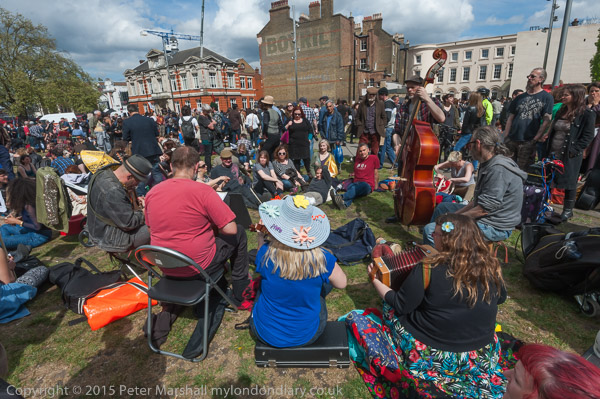
Perhaps it was partly due to this that the event taking place there seemed to lack any real cohesion with various groups doing their own thing in different parts of the large area and largely ignoring the speeches and performances at the Unite Community stage.

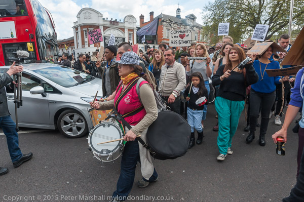
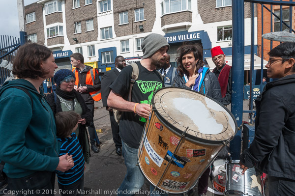
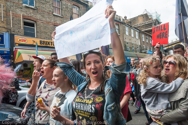
After an hour or so with not very much happening, activists decided it was time for a march and took to the road blocking traffic and walked up Brixton Road.

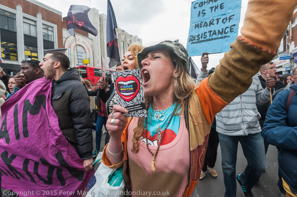
They stopped for a while outside Brixton Underground, drumming and dancing and shouting.

Then they marched along Atlantic Road and rather to my surprise returned directly to Windrush Square along Coldharbour Lane.

Marcia Rigg, Sean Rigg’s sister, still fighting for justice for her brother’s killing by Brixton police in August 2008 and friend

I hung around for a while in Windrush Square where nothing much was still happening slowly and things seemed peaceful. I decided I had done enough for the day and left.

This was a mistake. Shortly after (probably when Class War came out of the pub) sthings kicked off and some people stormed and briefly occupied Lambeth Town Hall, a large window at Foxton’s estate agents was broken, and a few activists went into Brixton Village with banners.

Many more pictures on My London Diary:
London Black Revs ‘Reclaim Brixton ‘march
Reclaim Brixton celebrates Brixton
Take Back Brixton against gentrification
Brixton Arches tenants protest eviction


FlickrFacebookMy London DiaryHull PhotosLea ValleyParis
London’s Industrial HeritageLondon Photos

All photographs on this page are copyright © Peter Marshall.
Contact me to buy prints or licence to reproduce.


Bon Marche, Police, Acre Lane and Tate

Wednesday, September 6th, 2023

Bon Marche, Police, Acre Lane and Tate: My walk which began in Clapham on Sunday 4th June 1989 continues in Stockwell. It began with Light & Life, Pinter and Stockwell Breweries and the previous post was More Stockwell Green & Mary Seacole.

240-250 Ferndale Rd, Brixton, Lambeth, 1989 89-6a-61

Possibly before going to Stockwell Green, perhaps even at some point on my previous walk I made some more pictures around the centre of Brixton. Unfortunately film doesn’t come with meta-data and my memory is not as reliable as EXIF data, but these pictures were certainly made around the end of May or beginning of June 1989 and so I’ll share them here.

240-250 Ferndale Rd on the corner with Stockwell Ave, just a few yards back from Brixton Road was built in 1905-6 as an annexe of Bon Marche department store, later becoming Post Office with council offices on the upper floor. You can see a post office sign at the left of my picture. A photograph in the Lambeth Archives taken around 1975 show it as offices for Christian Aid and it was later home to the Refugee Council. The ground floor more recently became Canova Hall, a restaurant and the building was revived as The Department Store, “to create a series of collaborative workspaces supported by an evolving hub of creative, retail and community uses“.

Edmundsbury Estate, Ferndale Rd, Brixton, Lambeth, 1989 89-6a-64

This estate was complete in 1929 for the London County Council as Ferndale Court to house police officers in the City of London Police, but converted into council flats managed by Lambeth Council in 1979 when one of the blocks was demolished to leave a public open space. They were designed by Sidney Perks, who was surveyor to the City of London from 1908 before being appointed as its architect in 1928.

Adjoining the site to the east was the City of London Police Sports Club ground, now the Ferndale Community Sports Centre.

Acre Lane Mouldings Ltd, Acre Lane, Brixton, Lambeth, 1989 89-6a-52

A board illustrates the range of skirting architraves and cornices the company could supply, ‘Quality Mouldings for That Finishing Touch!‘.

Acrelane Timber Ltd is still at this site in Brixton and can perhaps still supply some similar items. A previous frame, not yet digitised shows a little of the frontage offering heating and plumbing supplies.

In my father’s workshop, a very large shed with store rooms and work benches at the back of his family house in Hounslow, long sold off and demolished, I was intrigued as a child by many of the old tools used around the start of the 20th century which included a range of moulding planes used to produce shaped mouldings such as this, used in his father’s cart building business. Back when my elderly aunts moved out around 1970 there was little interest in things like this and I imagine they ended up in landfill, though I’ve since viewed far less impressive ranges in museums.

Lambeth Town Hall, Acre Lane, Brixton Hill, Brixton, Lambeth, 1989 89-6a-54

I turned back along Acre Lane to the junction with Brixton Road where I photographed the grandiose Lambeth Town Hall, complete with a banner advertising an event about child benefit taking place on June 2nd, as well as a sign about going to Lambeth Debtline for debt advice.

Grade II listed Lambeth Town Hall was built in 1905-8, designed by Septimus Warwick and H Austen Hall in what is described as a modified Baroque style, and was further raised and extended 1935-8. I think the clock tower looks like some strange parody, an ornament which doesn’t really belong but has somehow thrust itself up through the ceiling of the main building and flowered extravagantly, reminding me of an amaryllis.

Tate Bust, Tate Library, Brixton Oval, Brixton, Lambeth, 1989 89-6a-55

This area was a pleasant garden before being destroyed by Lambeth Council to produce a windswept waste to discourage local people gathering here. It hasn’t really worked, just become less comfortable with oddly placed fixed chairs and the wind certainly rushes through the renamed Windrush Square. I think I might have come here in 1989 to sit and eat my sandwich lunch.

Henry Tate was born in 1819 in Lancashire, the son of a Unitarian minister, and set up a successful grocery business with six shops in the Liverpool area before going into partnership with sugar refiner John Wright there in 1859. When this partnership came to an end he founded Henry Tate & Sons with his sons Alfred and Edwin.

Tate introduced new more efficient refining techniques for the production of white sugar, and his business expanded and in 1878 he opened a large refinery at Silvertown still producing sugar now.

Fountain, Tate Library, Brixton Oval, Brixton, Lambeth, 1989 89-6a-56

Tate was an employer who took care of his workers and supported many educational projects including free libraries in Streatham, Balham, South Lambeth and Brixton as well as hospitals. After he had built and opened a gallery on Millbank and presented his art collection to the nation he was told Queen Victoria would be offended if yet again he refused a title, and he became a baronet in 1898, a year before his death.

The business was merged with that of Abram Lyle & Sons in 1921, probably causing Tate to turn in his grave, as he had despised Lyle, not least for the way he treated his workers.

Reliance Arcade, Electric Avenue, Brixton, Lambeth, 1989 89-6a-41
Reliance Arcade, Electric Lane, Brixton, Lambeth, 1989 89-6a-41

The Art Deco Reliance arcade was built into an exiting Georgian house and other buildings between Brixton Road and Electric Lane in 1923-5, its Egyptian style terracotta inspired by the 1922 discovery of Tutankhamun’s tomb.

Home to around 30 businesses it was since 2014 this Grade II listed arcade was on English Heritage’s at risk list but was renovated in 2019-20. There are some good pictures from this time by Mike Urban on Brixton Buzz from before and close to the end of the renovation.

My account of this walk will continue in a later post.


Railton Road, Herne Hill

Tuesday, July 18th, 2023

The next episode in in the series of posts on my walk in south London on Sunday 7th May 1989. The walk began with Hanover, Belgrave, Chapel, Shops, Taxis. The previous post was Herne Hill, Dorchester and Carnegie.

Shops, Railton Rd, Herne Hill, Lambeth, 1989 89-5f-62

I wandered up Railton Road from the junction with Dulwich Road towards Herne Hill station. Herne Hill only appears to have got its name relatively recently, with the Herne Hill Society stating that the first documented reference dates from 1801. Earlier maps show it as King’s Hill or Dulwich Hill.

Neither of the two derivations they give seems particularly likely, with an Old English root hyrne (corner, angle) hyll seeming unlikely from the late appearance of the name and a roost of large numbers of heron on the nearby River Effra seems fanciful. Other possibilities put forward have been that it was named after a family called Herne who apparently lived here in the 17th century.

Perhaps the name really does come from Herne the Hunter, the mythical resident of Herne’s Oak in the Windsor Forest some twenty five miles or more to the west, transferred here by an early developer of the area who perhaps saw oak trees which reminded him of that place, perhaps also hearing the rattling of chains and ghostly moans in this area. Who knows?

Railton Road was apparently one of the roads developed in 1868, a few years after the coming of the railway, the station on this road opening in 1862. Until then the area had been one of large villas with leafy gardens for the wealthy, but soon became full of “smaller houses for clerks, artisans, craftsmen and their families, the workers taking advantage of cheap fares for commuting into London.

Shops, Railton Rd, Herne Hill, Lambeth, 1989 89-5f-63

The building at 222 Railton Road, here the Herne Hill Bingo and Social Club, was the Herne Hill Cinema, said to have opened in 1914, although there appears according to a postcard on Brixton Buzz to have been a cinema around here earlier than that. It’s narrow facade opened to a much wider auditorium behind which could seat 750.

Brixton Buzz quotes Cinema Treasures giving more information about its 1932 design by George Coles and closure as a cinema in 1959, but says it continued in use as a bingo club until 1986, then becoming shuttered and empty. Clearly it was locked and barred when I photographed it in 1989, and has a notice too small to read on its door, but doesn’t look in too poor condition. It is now a private bar, but apparently the auditorium area behind was demolished and housing built on the site.

Herne Hill Station, Railton Rd, Herne Hill, Lambeth, 1989 89-5f-66

Herne Hill Station was opened at the bottom of Herne Hill on Railton Road by the London, Chatham and Dover Railway in 1862. At first it was a terminus, with services only towards Victoria, but a year later the line was extended to Beckenham and by the end of the decade there were also services to “the City of London, King’s Cross, Kingston via Wimbledon, and Kent, including express trains to Dover Harbour for continental Europe.

The building with its polychrome brick Gothic tower seems excessive for what was a small suburban station, and was certainly intended to impress. The tower held the water tank needed by steam locomotives. The Wikipedia article quotes The Building News description of the station from 1863 as “spacious and convenient … and of the very best quality” and states “an unusual amount of decorative taste has been displayed“. It became an exempler of Victorian railway architecture.

Shops, Railton Rd, Herne Hill, Lambeth, 1989 89-5f-65

This view looks toward the corner with Rymer St, which now takes traffic from Railton Road to Dulwich Road as Railton Road a little further north is now a no-entry street for motorised traffic other than buses.

At left is 200 Railton Road and at right, next to an alley is an accomodation bureau and letting service at 289, now the home of Herne Hill Books. Apparently this stretch of road was until 1888 known as Lett Street. The alley was once a public footpath, and looks as if it was still in 1989.

This view still looks much the same now, with the two 19-storey blocks of Park View House and Herne Hill House in Hurst Street, each built in 1966 with 72 flats, towering over the neighbourhood. Park View House many be blessed with a view of Brockwell Park, but unfortunately you can see it and its neighbouring tower from the park.

Railton Rd, Rymer St, Herne Hill, Lambeth, 1989 89-5f-51

A closer view of 200 Railton Road. I have been unable to find out more about this building. Two of the three ground-floor shops appear to have been converted to to residential use by the time I made this picture.

Shops, Railton Rd, Herne Hill, Lambeth, 1989 89-5f-55

I walked back down south down Railton Road to the junction with Dulwich Rd, stopping to photograph this terrace of shops at 315-323 Railton Road. This is now a pedestrian area and the shops are rather different in nature.

I liked the sign at left on 315, ‘Only the best is good enough for me‘ though with the metal shutters up on a Sunday I could not be sure what it sold, though I think it was probably a greengrocers.

To be concluded in another post.


Loughborough Estate, Angell Town & a Garage – 1989

Sunday, June 25th, 2023

The fourth post on my walk in Kennington and Brixton on Sunday 6th May 1989. The posts began with Hanover, Belgrave, Chapel, Shops, Taxis. The previous post was Brixton Road and Angell Town -1989

Loughborough Estate, Flats, Loughborough Rd, Brixton, Lambeth, 1989 89-5d-44

I’m not sure which of the nine eleven-story slab blocks on the estate is shown in my picture; the estate was and remains a rather confusing area. Possibly this is Leicester House on Loughborough Road, or more likely Harpur House on Angell Road where I think I walked to next, but the lower buildings in front of the block appear to have gone.

The sign ‘NO HATS’ is not a reference to any headgear but to Housing Action Trusts, an important part of Margaret Thatcher’s marginalisation of local authorities. Having ochestrated the run-down of council estates by earlier restrictions on council spending and the right to buy schemes, the Housing Act 1988 aimed to transfer these estates to non-departmental public bodies which were to redevelop or renovate them so they could be transferred into private ownership.

Opposition to HATs was intense, with the Labour Part, local authorities and estate residents all fighting their imposition, and the first six areas intended to becom HATs managed to avoid implementation, though later six were formed, but none in south London.

Lunch Club, Loughborough Estate, Angell Rd, Brixton, Lambeth, 1989 89-5d-45

I think this rather temporary-looking building as on Angell Road close to Harpur House, but no sign of it remains. I photographed it largely for the posters showing opposition to Housing Action Trusts in Broxton.

As well as a Luncheon Club for pensioners it also has a sign for the Loughborough Sports & Social Club.

Fence, St John the Evangelist, Angell Park Gardens Angell Town, Lambeth, 1989 89-5d-32
Fence, St John the Evangelist, Angell Park Gardens, Angell Town, Lambeth, 1989 89-5d-32

Further along Angell Road – named like the area after the Angell family who had owned large parts of the Lambeth and developed this area in the 1850s. In 1852 Benedict John Angell gave a site here for the building of St John the Evangelist Church which was consecrated in 1853. Unfortunately trees along the edge of the site along Angell Road and Angell Park Gardens had too many leaves in May to clearly see the church.

These paintings on the fence around the church are still visible but rather faded. I took a few pictures of them both in black and white and in colour before walking on past the church and across Wiltshire Road into Villa Road and back onto Brixton Road, where I photographed the rather austere Our Lady of the Rosary Catholic Church (not yet digitised.)

Abeng Youth Community Centre, Gresham Rd, Brixton, Lambeth, 1989 89-5d-22

I walked on down Brixton Road to the Police Station where I turned back east along Gresham Road, stopping to photograph what looked to me to be a former chapel. In 1877 this was the Angell Town Institution and later became Brixtons first telephone exchange.

In the 1970s the Rev Tony Ottey founded the Abeng Centre here to provide supplementary education and youth services to the local children. In 2003 it was relaunched with new management as the Karibu Centre, its Swahili name Karibu meaning welcome, with similar aims. It is also hired for weddings, funerals, birthdays and business meetings.

Wyck Gardens, Loughborough Estate, Millbrook Rd, Brixton, Lambeth, 1989 89-5d-24

Soon I was walking through the Loughborough Estate again, going along Millbrook Road and through Wyck Gardens, a public open space which is thought to be the remnant of a larger wood knwon as Wickwood in the Manor of Lambeth Wick which had been cleared by the end of the 17th century.

The land had belonged to the Archbishops of Canterbury and was bought by the London County Council from the Church Commissioners for a new public open space, opened in 1959 and since extended and improved. You can see more pictures from the park on Brixton Buzz.

I think the large block here is Barrington Court, the first of three I walked past on my way through the park towards Loughborough Junction.

Garage, Railway Arch, Ridgway Rd, Loughborough Jct, Lambeth, 1989 89-5d-25

I left the park and walked along Ridgeway Rd, beside the railway line from Brixton which curves around to a junction just north of Loughborough Junction Station. The next station on this line is at Elephant & Castle.

Some extensive work seems to be in progress on what I am reliably informed (thanks to comments on Flickr) is a Ford Escort, while inside the garage a Renault 4 and a Rover P5 await their turn.

Arch 500 was empty for some years but later became home to the very Brixton Buzwakk Records Recording Studio a few years ago. The arches on both sides are still garages.

More about this walk in May 1989 in a later post.


Naked Ladies, 3 Doors & A New Walk

Tuesday, June 6th, 2023

Naked Ladies, York House Gardens, Twickenham, Richmond 1989 89-5a-53

I took few pictures in the rest of the month after my walk on Sunday 9th April 1989, my time being taken up with other things. I did make a few pictures on a CND demonstration in Lambeth with family and friends which I’ve yet to digitise, and some when the photography adult class on which I was assisting went to photograph Twickenham’s famous ‘Naked Ladies’, who now have a beer named for them. Some of my pictures of this were made on large format 4×5″ film so I could contact print them using historic processes such as platinum and kallitype, and I helped make at least one on 8×10″ for the tutor.

Upper St Martin's Lane, Covent Garden, Westminster, 1989 89-4l-13
Upper St Martin’s Lane, Covent Garden, Westminster, 1989 89-4l-13

And there were a few other pictures such as this, made on my way to the Photographers’ Gallery, then in Great Newport St, a short walk around the corner, or on my way to meetings in other parts of London, and a few closer to home.

Cowley Rd, Myatt's Fields, Camberwell, Southwark, 1989 89-5a-35
Cowley Rd, Myatt’s Fields, Camberwell, Southwark, 1989 89-5a-35

But my next walk to take pictures came on Friday 5th May when I rushed out of college after around four hours of teaching and jumped on a train to Vauxhall and a bus to the Oval, walking down Foxley Road, then Vassal Rd to Cowley Rd, eager to continue to photograph in the area around Myatt’s Fields. I paused to take half a dozen pictures on the way, but have yet to digitise any of these.

Cowley Rd, Myatt's Fields, Camberwell, Southwark, 1989 89-5a-22
Cowley Rd, Myatt’s Fields, Camberwell, Southwark, 1989 89-5a-22

The top end of Cowley Road is in the Vassall Rd conservation area and this terrace is a remnant of the Holland Town Estate development begun by Henry Richard Vassall, Third Baron Holland in 1818 when Camberwell New Road was laid out. This terrace is possibly from around 1830 and its Grade II listing describes it as Early-mid C19.

Cowley Rd, Myatt's Fields, Camberwell, Southwark, 1989 89-5a-25
Cowley Rd, Myatt’s Fields, Camberwell, Southwark, 1989 89-5a-25

No 25 at the right of the previous picture is the last house in this section of the street. On the west side of the road, behind me as I took the picture is a large block of redbrick five-storey council housing, Knowlton House, built by the LCC as part of the Cowley estate in 1934-6. There is another similar block, Stodmarsh House further south on the street.

The park here appears to have had a number of names and is now Eythorne Park, though Google Maps hedges its bets by also calling it Myatt’s Field Common Park and on the old A-Z I used on my walks it was Mostyn Gardens, given to Lambeth Borough Council in 1925 who passed on the the LCC in 1958. They extended and renamed it Melbourne Fields. Parts of it were built on in the 1970s the low-rise Myatts Field North council estate in the 1970s and disastrously redeveloped under a Private Finance Initiative programme hit by various cost-cutting directives and carried out with little or no regard for the residents.

Eythorne Rd, Myatt's Fields, Camberwell, Southwark, 1989 89-5a-26
Eythorne Rd, Myatt’s Fields, Camberwell, Southwark, 1989 89-5a-26

You can see these roofs over the mound in the park in the previous picture, though the park is now flat and surrounded by the redeveloped buildings. These buildings looked in good condition in 1989 and the estate looked well designed and a pleasant place to live. But years of neglect by the council meant that in 2004, as Zoe Williams wrote in The GuardianMyatts Field North in Lambeth, south London, was a byword for what goes wrong on a housing estate. It had been poorly maintained; the interiors were shabby. Garages had become hazardous and were out of bounds; shared spaces were desolate and only teenagers and children used them, “engaged in nothing very positive”, according to a council report at the time.”

The state of the estate in 2004 led residents to vote by a fairly small majority for the council’s plans for regeneration, “demolishing and rebuilding 305 homes, refurbishing 172“, but work only began in 2012, by which time the plans had been considerably altered with cuts to the budget. Five years later when Williams wrote her article the problems with the regeneration were clear, with the refurbished homes poorly plannede and shoddily implemented and the residents many complaints largely simply ignored.

Mike Urban’s 2020 photographs on Brixton Buzz, the prairie like fields of Eythorne Park, Myatt’s Field North, south London, give a good impression of the present state of the park.

St John's Schools, Camberwell New Rd, Camberwell, Southwark, 1989 89-5b-62
St John’s Schools, Camberwell New Rd, Camberwell, Southwark, 1989 89-5b-62

St John The Divine Junior Mixed and Infants School is still there on Camberwell New Road, though ILEA has long gone and the entrance to the school is now on Warham St, as it probably was when I took this picture. The church itself is a short distance away in Vassall St and is a good example of Victorian gothic by George Edmund Street. The parish was created in 1871.

The school, with buildings in Warham St (then James St) opened in 1872 for 400 children but this building on Camberwell New Road came some years later.

Shops, Camberwell New Rd, Camberwell, Southwark, 1989 89-5b-63

The school building in flanked on both sides by shops and is in the centre of a terrace. Edward Wells & Sons Ltd at 143-145 offered a wide range of printing services. I think the businesses closed soon after I made this and other pictures.

My walk will continue in a later post.