Beltane, Chariot Festival, Barking & Whitechapel: I had an interesting and varied day at events and places across London on Sunday 28th May 2006, taking rather a lot of photographs. Appropriately for a Sunday I covered two religious events.
Pagan Pride – Beltane Bash – Holborn
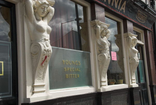
My working day began at Holborn, having caught a fairly early train into London. Now I like to relax a bit on Sundays, but for many years I often came up by the first train to take photographs. Though it wasn’t that early on Sundays, departing around 8am.
I took a bus from Waterloo to Holborn and walked the few yards to the Conway Hall at the north-east corner of Red Lion Square.
Here (with corrected capitalisation) is what I wrote about this event on My London Diary in 2006.
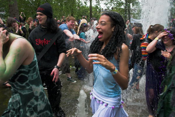
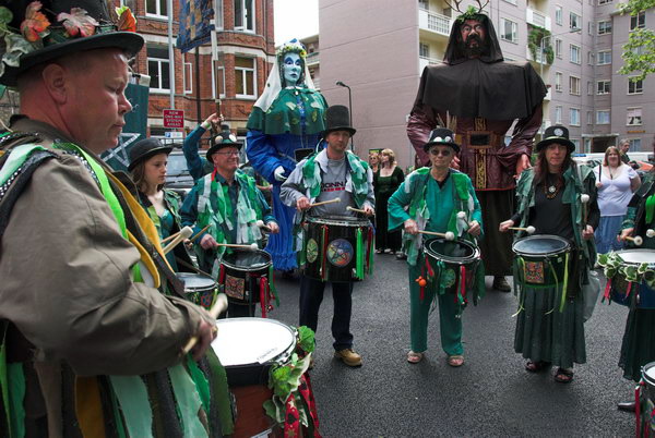
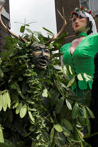
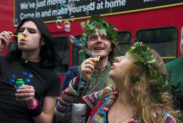
The Pagan Pride Parade in Holborn is now a regular annual event, a part of the Beltane Bash that takes place in the Conway Hall in Red Lion Square. Mostly it was the same people as last year, but I found it hard to get into the mood to take pictures.
As usual the parade was led by Jack In The Green – a dancing bush – the Green Lady and the Bogies. The Giants included the Morrigan (in green and flowers to welcome summer) with Black Ravens, Old Man Thunder and Old Dame Holder, along with the rest of it.
Dancing round the fountains was energetic, but somehow for me the event didn’t really get going, and lacked any real climax, people just slowly began to fade away.
Chariot Festival, Sri Mahalakshmi Temple – East Ham
Those taking part in the Pagan Pride parade began to make their way back to Conway Hall for the rest of their day of events, but I rushed to Holborn underground station to take the Central line eastwards, changing at Mile End to get to East Ham. But I had stayed too long with the pagans.
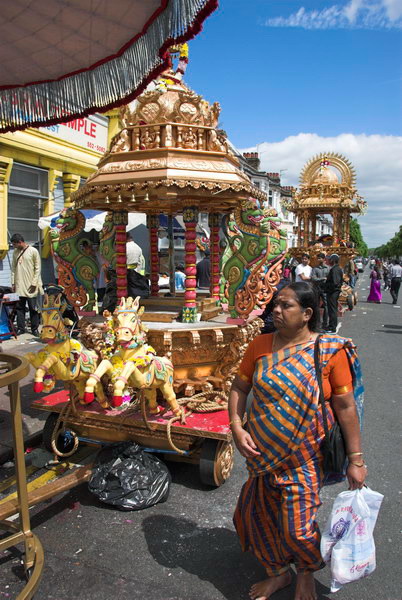
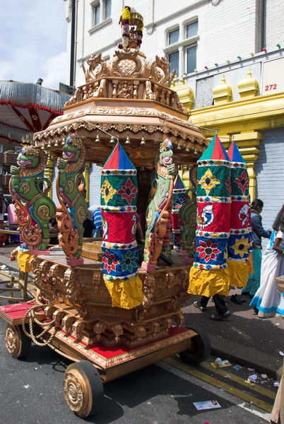
The Sri Mahalakshmi Temple had been built in 1989 and opened and was almost opposite the station. Before that Hindus and worshipped at a converted shop on the corner of Kensington Avenue and High Street North, around 300 yards north from the station.
Unfortunately I had arrived too late and the procession on the streets had ended, though I was still able to photograph the chariots outside and a few of the people. I made a mental note to come back and cover this event another year, but although I photographed other chariot festivals including one in Manor Park, East Ham, I’ve never returned for this one.
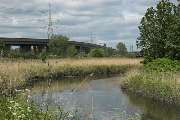
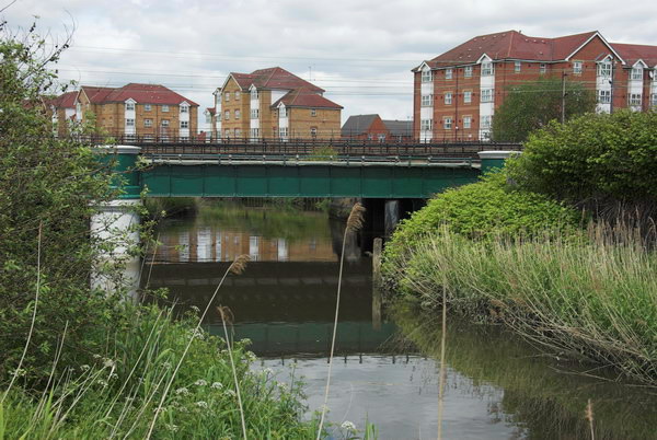
I was in East Ham and the afternoon lay ahead; it was a fine day and I decided this was a great opportunity to take a walk a little further to the east by the River Roding. I took a few pictures of the chariots, then went to walk along by the River Roding and to photograph a new development by the railway in Barking.
The half-mile walk along unkonwln was rather uninteresting. It’s a long suburban street lined with terraces of working class housing from the early twentieth century on both sides, named for the family who once owned the estate on which it was built. As Stephen Benton points out in his London Postcode walk it has one small claim to fame, and almost every famous pop guitarist from the the 70s and 80s – including those from the Beatles, Rolling Stones, Yardbirds, The Who as well as musical failures like me will have started with Bert Weedon’s ‘Play in A Day – Guide to Modern Guitar’, first published in 1957. Weedon (1920-2012) was born here, though he had probably moved away long before he became famous.
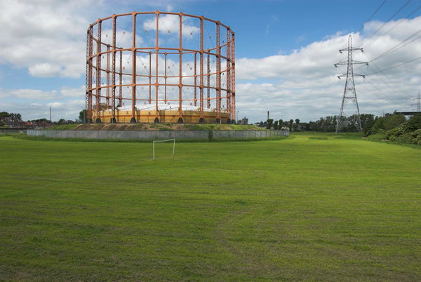
The path led on to Watson Ave, with a view of the Leigh Road gasholder in what is now the derelict Leigh Road Sports Ground. The Barking Gas Works opened here in 1836 but was purchased in 1912 by the Gas Light and Coke Company, who closed it as they had the much larger and more economical works they had opened at Beckton in 1870. But the holder remained and was I think still in use by the North Thames Gas Board possibly until the change from coal gas to natural gas. The area around it became their sports ground.
At the end of Watson Ave is a long footbridge which took me over the North Circular Road, from which I took a few pictures before going through an industrial estate.
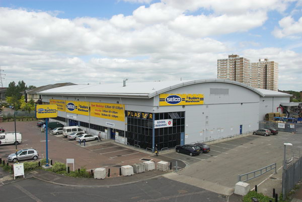
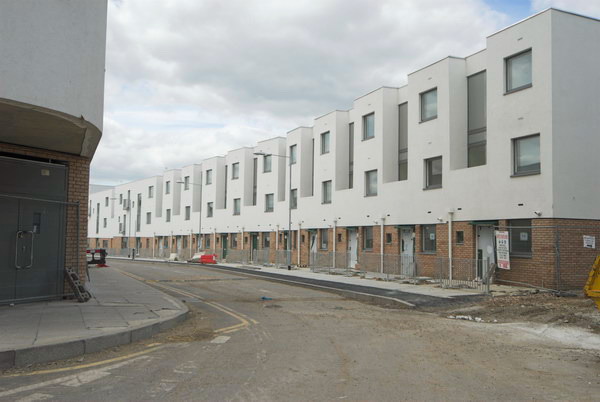
I made quite a few pictures in the Tanner Street area, where a considerable amount of new development was taking place.
I told myself I would return here later, but I don’t think I’ve done so yet.
I think I had travelled back from Barking on a Hammersmith & City line train and needed to change soemwhere to the District Line. Having got off the train I decided I had time for a short walk around on before needing to continue my journey. I only taok a few pictures, perhaps making 20 exposures, and there are only four pictures on My London Diary.
Around the Abbey in Bermondsey 1988 Railway arches have played an important role in the economy of London and other cities, but particularly in London south of the river, where from the start around 1840 lengthy viaducts were built, beginning with this long one east from London Bridge which cut a gap through Bermondsey. The arches provided relatively low cost premises for small businesses, giving something back to the area in compensation for the damage the railways caused.
This particular business had closed and despite the fence had become a hand area for fly-tipping, with many houses in the area being cleared as gentrification was setting in. Furniture and other items that once would have gone to secondhand shops was simply being disposed of as cheaply as possible.
Unfortunately railway arches are now being refurbished as Network Rail sees them as a real opportunity to profit from its large estates, with often long-term tenants being forced out and the refurbished arches being let at three or more times the previous rents. A long battle was fought against this recently in central Brixton, where most of the previous businesses were forced to close.
Abbey St, Bermondsey, Southwark, 1988 88-10r-23
Former warehouses are boarded up and awaiting demolition on Abbey Street close to the junction with Maltby Street.
Maltby St, Bermondsey, Southwark, 1988 88-10r-24
All these buildings in Maltby Street have been demolished and it is hard to locate the exact location which I think was on the part of the road leading from Abbey St to Grange Walk. The sign on one of this range of commercial buildings was for ‘DIAMOND GLASS-FIBRE’.
Bermondsey United Charity School for Girls, Grange Walk, Grigg’s Place, Bermondsey, Southwark, 1988 88-10r-11
The BERMONDSEY UNITED CHARITY SCHOOL FOR GIRLS was, according the the text on its side, ERECTED A.D.1830 and was more recently used as St Mary’s youth centre. It and the terrace along Grange Walk to the east remain and the school has been converted into flats.
This row of late seventeenth century houses on the right hand side of the street are all Grade II listed and Nos 5-7 at right of picture apparently include in their structure part of one side of a late medieval stone gatehouse to Bermondsey Abbey. However I don’t think any of this is visible, and despite various accounts elsewhere they are not the abbey gatehouse, though they show its position.
The more modern structure at the extreme right was recently demolished. On Tower Bridge Road it used to advertise itself as ‘The Bermondsey Indoor Antique Market’ on the Tower Bridge Road frontage withe the message ‘Open Every Friday’ on a board above its Grange Walk side.
Walter Coles, Tanner St, Bermondsey, Southwark, 1988 88-11d-65
Although these last two pictures are filed in my contact sheets under November, my note on the sheet says they were taken earlier than the first November sheet and I think they were taken on this walk.
Walter Coles & Co Ltd sold polythene bags from this warehouse at 47-9 Tanner St, just a few yards east of Tower Bridge Road. Since 2012 it has been an arts venue, Ugly Duck.
The buildings to the right of the warehouse were all on Tanner Street, which turns round towards the north, and have all been demolished and replaced.
Abbey St, Bermondsey, Southwark, 1988 88-11d-51
Two notices had once been here but both had gone. One was replaced in 2019 letting us know this was St Saviours Estate and Purbrook Estate. This is Attilburgh House on the corner of Abbey St and Riley Road, a seven storey council block built on the site of five large houses on the street as a part of the St. Saviours Estate and I think dates from the 1960s. Its name probably comes from the old name for Attleborough, a market town in Norfolk not far from Thetford which gave its name to a neighbouring block.
Like most council housing, many of the flats here have been bought by tenants under Thatcher’s popular but disastrous ‘right to buy’. Many who did buy were unable to keep up with mortgage repayments and repair costs, and so many were fairly quickly sold, often to ‘buy to let’ investors who let them out at several times the council rents, enough to more than pay the costs of the mortage or bank loan, the new tenants buying the flats for those investors. A few years ago this estate featured in a court case after Southwark Council found that fire doors required replacement and tenants too them to court over the charges they imposed.
I think this was probably the end of my walk on 30th October 1988. Two weeks later I was back in Bermondsey taking more pictures, the subject of my next series of posts.
I walked past Dockhead and along Tooley Street, turning down Tower Bridge Road and on to Tanner St making a few photographs, but have only digitised the two shown here. Dockhead is of course at the head of St Saviour’s Dock and until a bridge was built across the mouth of the dock walkers by the river had to take the route past Dockhead – and I often took a picture looking down the dock towards the Thames and this was no exception, but I haven’t yet digitised it.
The building with the circular window on its top floor was Jacob’s Biscuit Factory – another of whose buildings on Wolseley street featured in the previous post.
And although I made half a dozen exposures on Tooley St, one on Fair Street and several on Tower Bridge Road, this is the only one on-line. I do sometimes find it hard to know why I’ve not scanned some images and perhaps one day I’ll come back and fill in the gaps. But for the moment this is the only picture here from this section of the route.
It shows the two buildings on the corner with Lafone St, which runs north from Tooley Street to Shad Thames. Tower Coachworks has been demolished and replaced by new flats, but the large warehouse blocks at left, which run across the whole block to Boss St and up Lafone St to Queen Elizabeth St was refurbished by the London Docklands Development Corporation into a large residential development, Boss House. Q’s Ltd Snooker & Pool Club with its line of arrows to guide even the most shortsighted or inebriated to its entrance at rear has long gone. The three warehouses dates from somewhere around 1900 and there was a short street across the middle, Goat St, whose name can just be seen above the van parked on Lafone St, at least on a larger version of this frame.
Sarson’s vinegar works were on a large site on Tower Bridge Road with these vats viewed from Tanner St. Their presence was very apparent by the smell which pervaded the area – I couldn’t walk past without thinking of fish and chips – although according to Wikipedia production had moved to Manchester in 1968, it actually continued through the 1980s and the works only closed in 1992.
Thomas Sarson is said to have first brewed his malt vinegar in 1794 in Shoreditch, though apparently this date is unlikely and probably Sarson’s only made cheaper ‘wood’ vinegar until 1894. Sarson’s vinegar was briefly sold as ‘”Sarson’s Virgin Vinegar’ but that name was soon dropped. There is a very detailed article Just Say Sarsons by Tim Smith in a GLIAS Journal about the company with descriptions and photographs from a finely detailed recording visit. The vinegar works were begun by Noah Slee and a Mr Vickers around 1814, but later greatly expanded. The works were run by the Slee family until a merger with Champions in 1908 and their family connection continued until the formation of British Vinegars Ltd in 1932. Later they became a part of Nestlé and the Sarson’s brand is now owned by a Japanese vinegar company, who also own my favourite Hayward’s Pickled Onions.
The site was redeveloped from 2000 on, with its Grade II listed buildings being converted into flats and other buildings such as these vats being demolished and replaced by modern flats.
Tanner St, Bermondsey, Southwark, 1988 88-10q-32
Further west along Tanner St are these three adjoining buildings at 1-3 Tanner St. The Bermondsey Wire Works name has faded a little more but otherwise that building looks much the same, while Neon Manufacturers at No 2 is rather more tidier, has lost its original windows and all signage and has a new door and porch. No 3 has also had something of a face-lift but retains most of its former character, but the hoist no longer has a bucket attached.
Tanner St, Bermondsey, Southwark, 1988 88-10q-33
These buildings were still very obviously in commercial use back in 1988, but I think now most are studios, offices and residential, and I think I went to an exhibition in one of them a few years ago. Tanner Street was originally known as Five Foot Lane and most of it was on a map by 1544. The second part of the story by Richard Miller deals with it after it was renamed Russell Street in the late 18th century when it contained the Bermondsey Workhouse, and part 3 looks at it after Bermondsey Parish Council renamed it Tanner Street in 1881, reflecting the main trade then carried on there. The workhouse closed in 1922, and the site was bought with funds from selling St Olave’s Church in Tooley Street to Hay’s Wharf – and a part of that church’s tower, now Grade II listed, was installed as a drinking fountain in Tanner Street Recreation Ground which opened on the site in 1929. The park got a little larger in the 1990s.
Cockle & Co, Bermondsey Mesh and Wireworks were at 109 Bermondsey St from 1903-1919 and their works stretched around the corner here into Tanner St. According to the Bermondsey Boy web site, No 3 -7 were built in 1838 for three separate businesses but were bought by the Simmons Company, makers of perambulators, mail carts and stretchers in 1888 and later they also owned No 1 – you can see some of their advertisements on thesite. Simmons sold No 1 in 1952 and closed the business in 1959.
Bermondsey Square looks very different now to when I took this picture in 1988 and I think the actual position where I was standing may now be inside the ground floor of the Bermondsey Square Hotel. My shadow in the foreground shows me looking across the grass area towards the corner of Long Lane and Bermondsey St. The building then the Bermondsey Antique Market is still there – as is St Mary’s Church, but rather than antiques it is now ‘Flour & Grape’ which Google now tells me is an Italian restaurant and “A 3-min walk from the White Cube“. What is left of Bermondsey Square is now paved and although there is a small green area with seating at the front of the hotel it looks very plastic.