More Thamesmead Panoramas – 1994

More Thamesmead Panoramas: This final set of panoramic images came from my final visit to Thamesmead in November 1994.

Lesnes Abbey, Ruins, Abbey Wood, Bexley, 1994, 94-1104-42

I began and ended the day at Abbey Wood station and I no longer remember the route of the walk that I tookm but I think I began by going to the Lesnes Abbey Ruins. After the Norman conquest in 1066 land here was given to Bishop Odo, the half-brother of William the Conqueror and Bishop of Bayeux (and pictured on that tapestry he probably commissioned as a gift to his brother.)

Odo was the man who ran the country for his brother – until he was tried for fraud and disgraced. Odo was forgiven on William’s deathbed. But Lesnes Abbey was only founded in 1178 by the man then in charge of England for Henry II, Richard de Luci. He retired here then, possibly as a penance for his role earlier inspiring the 1170 murder of Thomas Beckett, and died three months after retiring.

The Abbey was always small and was closed by Cardinal Wolsey in 1525 as it had fewer than seven men living there. Much of the stones were taken away as building material with the abbot’s house becoming a part of a farmhouse. The London County Council bought the site and grounds in 1930 and opened it as a public park.

Abbey Way, Footpath, Footbridge, Abbey Rd, Thamesmead, Bexley, 1994, 94-1104-21

From the ruins I walked to the elevated footpath which leads into Thamesmead South.

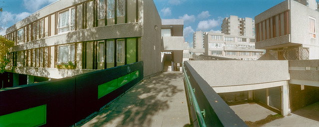
Abbey Way, Footpath, Footbridge, Abbey Rd, Thamesmead, Bexley, 1994, 94-1104-12

The footbridge goes across Abbey Road and to the north gives a view of the tower blocks of Thamesmead across the horizon.

Clocktower, Deptford Dockyard, Joyce Dawson Way, Thamesmead, Greenwich, 1994, 94-1003-32

I don’t think I made many other panoramas as I walked towards the river, and this is one I made on an earlier visit. It isn’t a good picture of the clock tower as it doesn’t show the clock!

When Convoys took over the old Royal Naval Dockyard in 1960 to bring newsprint into London they had no interest in its history and despite many objections they demolished the large Great Storehouse and many other old buildings on the site. The clock tower which had been a later addition on the top of this ancient wooden building was saved by urgent pleas and left by the riverside at Convoys Wharf when the building was demolished in 1981.

But it was still just a nuisance to Convoys and they still were threatening to demolish it. The tower was saved by the GLC and taken by boat to Thamesmead and erected here in the middle of a commercial centre.

Tavy Bridge Centre, Thamesmead, Bexley, 1994, 94-1102-22

At some point in my visit I made another visit to the Tavy Btidge Centre and made a few more panoramas.

Tavy Bridge Centre, Thamesmead, Bexley, 1994, 94-1102-11
Tavy Bridge Centre, Thamesmead, Bexley, 1994, 94-1102-12
Riverside Path, River Thames, Thamesmead, Greenwich, 1994, 94-1103-22

The River Thames is around a mile and a half away. On a previous visit I had taken another panorama from an almost identical position, but I think this is a rather better composition with the rail lined up carefully with the opposite shore.

These two lines are in the vertical centre of the image and so remain straight. Standing up a little to the right of centre above them is the Barking Creek Barrier.

Goldfish Are Wankers, Graffiti, Riverside Path, River Thames, Thamesmead, Greenwich, 1994, 94-1103-23

I couldn’t decide which was the more interesting work of art, the strange yellow sculpture or the graffiti on the wall behind. The wall is the flood barrier to protect Thamesmead, much of which is low-lying.

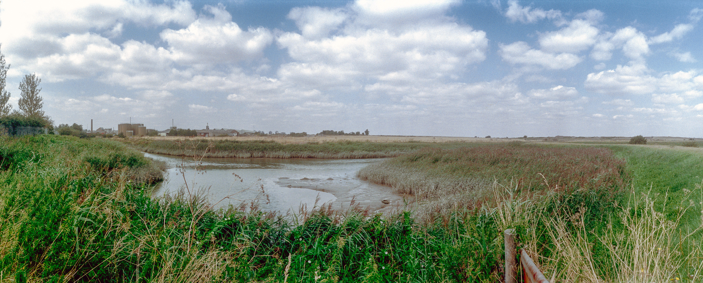
Crossness Nature Reserve, Thamesmead East, Bexley, 1994, 94-1101-61

The Crossness Nature Reserve is to the east of Thamesmead, just past the large Crossness Sewage Treatment Works. When opened in 1865 the the sewage from London south of the Thames was simply pumped into the Thames when the tide was going out, but a large area of land was taken over to treat it before release around 1890.

Crossness Nature Reserve, Thamesmead East, Bexley, 1994, 94-1103-41

This is the end of my posts of colour pictures from around Thamesmead in 1994 though there are still a few more in my Flickr colour album for that year – as well as others in the 1994 black and white album.


Flickr – Facebook – My London Diary – Hull Photos – Lea Valley – Paris
London’s Industrial Heritage – London Photos

All photographs on this page are copyright © Peter Marshall.
Contact me to buy prints or licence to reproduce.

Thamesmead & The Thames – 1994

Thamesmead & The Thames: More pictures from my October and November 1994 visits to Thamesmead.

Tavy Bridge, Thamesmead, Bexley, 1994, 94-1003-61

I hope the captions which I wrote at the time are accurate, but I found parts of Thamesmead rather confusing to walk around. There are both streets and raised walkways and various footpaths, and I don’t think the map was always too helpful.

Tavy Bridge Centre, Thamesmead, Bexley, 1994, 94-1003-63

However these shops were certainly at the Tavy Bridge Centre. Thamesmead is built on the flood plain and the whole area had been badly flooded before the new estate was developed. The planners decided to build with garages at street level and the living areas of the housing at first floor and above so as not to be vulnerable to floods.

Tavy Bridge, Thamesmead, Bexley, 1994, 94-1003-52

Some of the areas liable to flooding have since been rebuilt with housing at ground level. I assume that the river walls are now thought to be an adequate defence, but would not myself buy a house there.

Footbridge, Yarnton Way, Thamesmead, Bexley, 1994, 94-116-41

Sea levels are slowly rising as the earth gets hotter because of increasing levels of greenhouse gases from burning fossil fuels means that ice melts. The Thames Barrier still protects most of London, but will need to be replaced. Thamesmead is downstream of the barrier and so will need its own extra protection. At some point with high spring tides and an easterly gale this will be overtopped.

River Thames, Beckton, Canary Wharf, Thamesmead, Bexley, Greenwich, 1994, 94-115-44

I walked on to the riverside promenade, Thameside Walk. Looking towards the west both the remains of the Beckton gas works and Canary Wharf were visible though there was considerable haze due to air pollution in London.

River Thames, Ford, Dagenham, Thamesmead, Bexley, Greenwich, 1994, 94-115-45

Across the Thames and a little to the east was the vast Ford complex at Dagenham, its logo visible on the water tower at left.

Promenade, River Thames, Thamesmead, Bexley, 1994, 94-115-35

The river is stretches away east towards the estuary, turning around towards the south in the distance. At the left of the picture is the Essex bank. The river is a little over 2000 feet wide here.

The panoramic images here were taken on a Russian Horizon swing-lens camera, its 28mm lens giving a horizontal angle of view of around 127 degrees (often stated as 120.) The negatives, on standard 35mm film are 58x24mm, a similar width as a ‘6×6’ medium format camera though only 2/5 the height. It was possible to use the camera handheld, but for these pictures I used a sturdy Manfrotto tripod, usually working from a normal eye height of a little over 5 foot.

More to come from Thamesmead.


Flickr – Facebook – My London Diary – Hull Photos – Lea Valley – Paris
London’s Industrial Heritage – London Photos

All photographs on this page are copyright © Peter Marshall.
Contact me to buy prints or licence to reproduce.


Tavy Bridge, Thamesmead 1994

Tavy Bridge, Thamesmead: In October and November 1994 I returned to Thamesmead, a New Town which I had first photographed nine years earlier and spent a few days wandering around the area, developed largely from the end of the 1960s by the GLC under architect Robert Rigg to house families from poor and overcrowded Victorian working-class terraces, particularly those in East London.

Pyramid Club, Tavy Bridge, Thamesmead, 1994, 94-101-26

The planners hoped to grow some of the community that had existed in those working class areas by giving the families of the initial residents priority for new housing, and had s strong belief that the water in lakes and canals as a calming influence of those who lived among them. Neither policies were as effective as had been hoped.

Tavy Bridge Centre, Thamesmead, Bexley, 1994, 94-115-52

Thamesmead is on low-lying land on the bank of the River Thames and had been flooded in 1953, so the living accommodation on much of the housing began at first floor level, with walkways there where people would meet and children play as they had done on the streets back in their old homes. The ground level was for cars, with roads and garages.

Pyramid Club, Tavy Bridge, Thamesmead, Bexley, 1994, 94-115-53

It didn’t work out too well in practice, partly because of a huge increase in car use, in part driven by the isolation of Thamesmead and poor public transport as well as increasing affluence. Shops, schools, pubs and more which might have been at the corner of the old streets were now much further away, and people increasingly got into cars, leaving the walkways deserted. And for those who did walk, there were almost always shorter routes at ground level across the streets and grassy areas than on the walkways.

Pyramid Club, Tavy Bridge, Thamesmead, Bexley, 1994, 94-115-31

As I think my pictures show, at least in part the result was an empty and rather alienating landscape, much used in films, notably Stanley Kubrick’s dystopian 1973 ‘A Clockwork Orange’, based on Anthony Burgess’s 1962 novel. And in real life it seemed also to encourage high levels of drug-related crime and violence with often racist gangs.

Pyramid Club, Tavy Bridge, Thamesmead, Bexley, 1994, 94-115-32

Thamesmead lies across the boundary of two London boroughs, Greenwich and Bexley, and the abolition of the GLC in 1985-6 was also a disaster for the development of the town, with ownership first being transferred to a new body, Thamesmead Town Limited (TTL) and later in 2000 the housing to Gallions Housing Association with Tilfen Land taking over the undeveloped land.

Tavy Bridge, Thamesmead, Bexley, 1994, 94-115-33

The Tavy Bridge area where this first section of pictures was taken was redeveloped by Gallions together with Wates Group – and new homes were then built with living accommodation at ground level, so almost certain to flood.

Limestone Social Club, T.C.A., Limestone Walk, Thamesmead, Bexley, 1994, 94-116-56
Bus Stop, Tee Dee's, Hair & Beauty Salon, Thamesmead, Bexley, 1994, 94-116-55
Bus Stop, Tee Dee’s, Hair & Beauty Salon, Thamesmead, Bexley, 1994, 94-116-55

Along with these photographs (and more in black and white on Flickr) I also made a number of panoramic images around Tavy Bridge which will feature in a later post.


Flickr – Facebook – My London Diary – Hull Photos – Lea Valley – Paris
London’s Industrial Heritage – London Photos

All photographs on this page are copyright © Peter Marshall.
Contact me to buy prints or licence to reproduce.


Shops and More – October 1994

Pictures from the first dozen or so frames of a film taken as I moved around London near the start of October 1994, working on other things. I only recorded locations for two of these but perhaps someone may recognise where the others were taken.

Chinese, Fish & Chips, London Rd, Norbury, Croydon, 1994, 94-101-63

I think this is perhaps a Chinese takeaway rather than a fish and chip shop, though this counter could be a fish fryer and there does seem to be vinegar and salt on the counter. This is one of the few images in this section of the film that gives a location. Probably this was a corner shop as I seem to have taken the picture through a side window.

Re-Upholstery, Furniture, London, 1994, 94-101-65

A workshop in shop premises facing thee street which provides an advert for the re-upholstery service and a convenient location to bring in your chairs to be re-upholstered.

We have had some of our chairs re-upholstered in recent years at a rather more orderly workshop than this and it made them as good as new. Good chair frames on older chairs were made to last, though re-upholstering them cost us more than buying cheap new chairs. Two frames after the previous image this could too have been in Norbury – but I could also have been on the other side of London. Please comment if you recognise it.

Greengrocers, London, 1994, 94-101-66

Perhaps had I taken this on medium or large format instead of 35mm I would be able to find more about the location from the local newspaper at right or the lable on the wheelie-bin. But all I can tell you is that it was somewhere in London.

It looks rather crudely fitted out as a shop, perhaps converted from some other use. At right is a blurred image of my hand, held to largely avoid reflections as I took this though a glass front window.

Blue Pallets London, 1994, 94-101-51

A side street, perhaps a market area off a high street somewhere in London. The blue palletsd look more substantial than some and are marked with the letter C as well as a short message illegible in my photo. The building they are in front of has a metal shutter, probably hiding a shopfront, and has some bright green paint which contrasts with the brown above that, as well as the oddly sloping straight drainpipes from its roof.

Shops, Pembroke Rd, Erith Rd, Erith, Bexley, 1994, 94-101-52

Thee very next frame after the blue pallets is of a street corner in Erith with a small parade of shops, probably built in the 1920s or 30s. Most were derelict by 2008 though only demolished in 2014. Three shops at the Pembroke Road end of the terrace were still there in 2025 but nothing had been built to replace those demolished.

Reflections, Café Window,  London, 1994, 94-101-56
Reflections, Café Window, London, 1994, 94-101-56

An image where I liked the reflection and the ambiguity it introduces into the image. I think there may be two sets of reflections here. My focus was on the shel which ruans across the middle of the image with bottles – the leftmost is opf Table Salt, the next probably vinegar. Under it some pies are keeping warm but apparently also in a passing car while to their right are some kind of controls on equipment I don’t recognise and a boy riding a bike, given a red cap perhaps by a bottle label. I can see no trace of myself reflected in the image, susggesting I made it at an angle to the glass.

Shop Window, London, 1994, 94-101-41

And for a final mystery (at least for today) a shop window with Chinese items in it as well as a fluorescent fitting without its tube. At the top I think is a parasol and hanging below it a short-sleeved top. I wonder now if this picture was taken through tinted glass as I cannot really find a convincing colour balance. My shadow taking the image appears at bottom right.

More colour work from 1994 shortly.


Flickr – Facebook – My London Diary – Hull Photos – Lea Valley – Paris
London’s Industrial Heritage – London Photos

All photographs on this page are copyright © Peter Marshall.
Contact me to buy prints or licence to reproduce.


Hall Place & River Darent

Hall Place & River Darent: More from my walks by the River Cray and Darent in September 1994. Firstly a couple of pictures from Hall Place, Bexley where the River Cray runs through the grounds of a magnificent Tudor Hall.

Park, River Cray, Bexley Hall Place, Bexley, 1994, 94-906-62

The gardens are open free of charge all year round, and are well worth a visit – and dogs, footballs, BBQs or fishing are not allowed, making it very peaceful. I can’t remember exactly where in the grounds this was, perhaps at the north close to the A2 where there is a flood channel marked on the map.

Hall Place, Bourne Road Bexley, 1994, 94-901-61

Although you can see the exterior of the Grade I listed country house for free, you can only go inside on pre-booked guided tours. I once went on one of these and possibly these pictures were taken on the same day, but I took no pictures inside the house.

The main house was built in two stages, the first in 1537 for Sir John Champneys, a wealthy merchant and former Lord Mayor of London with the fine flint and rubble walls in my picture. Some of the stone used in its construction was recycled from the ruins of the former Lesnes Abbey not far away in Abbey Wood.

When the house was sold to a second wealth London merchant, Sir Robert Austen in 1649, he decided to double its size, extending it in red brick. Later buildings including a lodge were added in the Victorian era. In the 1920s the last tenant of the hall, then owned by her wealthy American son-in-law Stephen Cox Brady, was the eccentric Lady Limerick who added some mock-Tudor interior features.

Brady died in 1928 and the house and gardens were sold to Bexley Council, but the eccentric Lady Limerick lived there as a tenant until her death in 1945. During the war the house was also in use by US soldiers who were involved in the decoding of German messages, part of the operation centred at Bletchley Park and had the code name Santa Fe.

I think the next pictures were made a few days later.

Darent Industrial Park, Erith, Bexley, 1994, 94-912-23

I’ve walked around beside the River Darent and on to the Thames and to Erith a number of times, and more recently on my folding bike. Usually I’ve begun my walk either at Slade Green or Barnes Cray stations, though I think I may once have done it in the opposite direction.

Darent Industrial Park, Erith, Bexley, 1994, 94-912-42

The land here is on the edge of the marshes and was marsh and grass land until the 1879s when the Thames Ammunition Works, later part of VickersArmstrong, was established here. During World War I it employed thousands, many of them women, working long hours in hazardous conditions. The site officially closed in 1962, having been run down for some years and became home to a number of smaller companies.

Darent Industrial Park, Erith, Bexley, 1994, 94-913-32
River Thames, Crayford Ness, Erith, Bexley, 1994, 94-913-42

Taken from the low-lying ground immediately upstream of the confluence of the River Darent with the River Thames. At left is the QE2 bridge, with the chimney of Littlebrook Power station on the south bank – only finally demolished in 2019 though the plant had closed in 2015, and at right the Darent Flood barrier built in 1982. The riverside path runs along the top of the grassy bank at right.


Flickr – Facebook – My London Diary – Hull Photos – Lea Valley – Paris
London’s Industrial Heritage – London Photos

All photographs on this page are copyright © Peter Marshall.
Contact me to buy prints or licence to reproduce.


The Cray Riverway – 1994

The Cray Riverway is a 10 mile long path which follow the River Cray from Foots Cray Meadows to the junction with the the River Darent and along side this to the River Thames and then into Erith. Back in 1994 I walked along most or all of it, paying several visits to the area as I was a photographer rather than a walker and liked to wander rather than stride out.

River Cray, Barnes Cray, Bexley, 1994, 94-904-53

I think I took two different swing-lens cameras on these walks, both a Japanese and a Russian model which produces very similar results in terms of angle of view (just a little over a third of the entire view around me) and quality. I used both on a sturdy Manfrotto tripod, mainly working from my eye level, and using a nine-inch carpenters’ spirit level to try to level the camera both from side to side and front to back as I found the built-in levelling insufficiently accurate (and I didn’t always get it quite right even with the larger level.)

River Cray, Barnes Cray, Bexley, 1994, 94-904-41

In 1994 I was processing my own colour negative film and I think at times the negatives suffered a little either from my inaccuracies or from chemical issues, and I find it hard to get the colour of some images exactly as I would like them. The rest of these pictures are from Flickr, but one I’ve worked on the one above again since I uploaded it there.

Footpath, River Cray, Barnes Cray, Bexley, 1994, 94-904-42

I’ve already featured some of these images on earlier posts, but here I’ll include a few different images.

Barnes Cray, Bexley, 1994, 94-904-43
Crayford Riverway, Barnes Cray, Bexley, 1994, 94-905-51
A2, River Shuttle, Pub, East Rochester Way, Bexley, 1994, 94-905-21

Some pictures by the River Darent in a later post, as well as more from Bexley.


Flickr – Facebook – My London Diary – Hull Photos – Lea Valley – Paris
London’s Industrial Heritage – London Photos

All photographs on this page are copyright © Peter Marshall.
Contact me to buy prints or licence to reproduce.


Bexkleyheath & Crayford – 1994

Bexkleyheath & Crayford: I spent several days in mid-August in Bexley in south-east London visiting Bexleyheath, Crayford and Barnes Cray and some of the areas around, and returned to the area the following month. I think all the pictures in this post were made in August.

Crayford, Bexley, 1994, 94-812-45

Crayford obviously gets its name from a ford over the River Cray, the major tributary of the River Darent which it joins not far from here and short distance from where this flows into the Thames. Its name is thought to mean a fast flowing stream and it powered an number of mills on its route – including a paper mill at Crayford. The tidal creek is still navigable from the Thames to Crayford, and was apparently canalised in 1845. There were still barges serving the flour mill in the 1980s.

Crayford, Bexley, 1994, 94-812-33
Crayford, Bexley, 1994, 94-812-34
Crayford, Bexley, 1994, 94-812-35

Taken through the links of a fence.

The Frontier Post, Bar & Grill, Bexleyheath, Bexley, 1994, 94-812-21
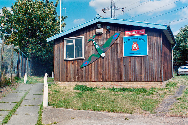
Spitfire Hall, Air Training Corps, Swaisland Drive, Crayford, Bexley, 1994, 94-812-11
Sainsburys, Petrol Station, Roman Way, Crayford, Bexley, 1994, 94-812-12

I returned to Crayford and Barnes Cray the following month, making a number of colour panoramas as well as black and white picture pictures which I’ll post at some time later – or you can find them in my Flickr albums for 1994.


Flickr – Facebook – My London Diary – Hull Photos – Lea Valley – Paris
London’s Industrial Heritage – London Photos

All photographs on this page are copyright © Peter Marshall.
Contact me to buy prints or licence to reproduce.


Belvedere Riverside & Plumstead – 1994

Belvedere Riverside & Plumstead: Some more pictures including some panoramas from my Thames riverside walk on Monday 1st August 1994, and a few from Plumstead a few days later.

Ford Ferry, Pier, River Thames, Belvedere, Bexley, 1994, 94-805-22

Ford at Dagenham was just on the opposite bank of the Thames, with a Ford ship moored in front of it and some ominous black smoke rising.

But although the Ford was only around 600 metres away, the fastest route for workers driving from here to the factory was around 15 miles. Taking the Woolwich ferry would take a couple of miles off this, but be slower.

Ford Ferry, Pier, River Thames, Belvedere, Bexley, 1994, 94-802-11

Many of Ford’s workers did live south of the river, either in Thamesmead or further away, and Ford provided a large suppposedly secure car park here from which they could walk down the pier to the Ford Ferry to take them across the river.

Ford had come to Dagenham in 1929 and opened the factory in 1931. They set up the private ferry for workers living in Kent in 1933. In its heyday it made 50 crossings a day taking as many as 1,500 workers to and from the plant, but after vehicle production ended with the plant turning to making engines it was only taking around 240 across and Ford discontinued it in 2003. Eventually they were forced to pay around half a million in compensation and to provide a bus service instead.

Much earlier there had been a Pilgrims ferry from Rainham to Erith, for pilgrims on their way to Canterbury, said to have begun in 1199 and to have continued in use until the mid 1950s.

Riverside Path, River Thames, Belvedere, Bexley, 1994, 94-802-12

Around here I turned back towards Erith, taking some more pictures on my way (some of which were included in my previous post.)

Riverside Path, River Thames, Belvedere, Bexley, 1994, 94-802-13

I can’t now remember exactly where on the path this was, but I think I walked all the way back to Erith and to the station there.

Penny's Cafe, Motor Auctions, Erith, Bexley, 1994, 94-803-32
Penny’s Cafe, Motor Auctions, Manor Road, Erith, Bexley, 1994, 94-803-32

Finally from that day in Erith, one I took earlier around the start of my walk but failed to post previously. Manor Road leads out east from Erith and was then an industrial area.

This Café (and Motor Auctions) had also clearly once been a factory and still catered for workers in nearby factories. Facebook posts say it had been an engineering factory called Ivor & Jettage, that the café was full of boxing photos and that its yard, used for motor auctions and later car boot sales on Sundays, was in 2024 a scaffolding yard. But I have been unable to confirm this.

Nathan Way, Plumstead, Greenwich, 1994, 94-806-52

A few days after my Erith walk I was back not far away in Plumstead, and made just a handful of colour images including these three.

This picture was made from The Ridgeway a foot and cycle path on top of the Southern Outfall Sewer from Plumstead to Crossness. Nathan Way runs for around 600 metres just to the north of this and most industrial sites along here were demolished by 2015 and are being replaced by a huge estate of blocks of flats, Lombard Square, with 1,913 new homes. The first were finished in 2025.

Nathan Way, Plumstead, Greenwich, 1994, 94-805-24

Another image from The Greenway not far from where I made the panorama above. From 1888-90 here or close by Royal Arsenal football team played here at what became the Manor Ground. They moved next to Woolwich, becoming Woolwich Arsenal but soon found the rent there too high and moved back. They played their last game here in 1913 before moving to Highbury in North London – and of course losing the Woolwich.

Some industry remains at the east end of this stretch of Nathan Way but I’m not sure this includes any in my picture.

Panoramic, Double Glazing, Nathan Way, Plumstead, Greenwich, 1994, 94-806-31

Nathan Way is a long road leading from Plumsteaad to Thamesmead and I think this may have been on the corner with Kellner Road.. But the name repeated on the lorry and the large modern shed behind as well as on what was perhas a small shed in the foreground was unmissable. I just had to make a Panorama.

Tony's Snack Bar, Nathan Way,  Plumstead, Greenwich, 1994, 94-805-26
Tony’s Snack Bar, Nathan Way, Plumstead, Greenwich, 1994, 94-805-26

I think the building at left it 115 Nathan Way, now occupied by Hydraquip Hose & Hydraulics, while behind are the roofs of Belmarsh Prison. But the picture is about the mobile snack bar here and the neat empty row of six white chairs for its then non-existent customers.

My walk continued on into Thamesmead but although I took quite a few black and white pictures I can’t at the moment find any more colour – and perhaps I took none.


Flickr – Facebook – My London Diary – Hull Photos – Lea Valley – Paris
London’s Industrial Heritage – London Photos

All photographs on this page are copyright © Peter Marshall.
Contact me to buy prints or licence to reproduce.


More From the Riverside – 1994

More From the Riverside: More pictures from my walk by the River Thames at Erith and Belvedere on Monday 1st August 1994 to its end in Plumstead.

My previous post from this walk, Thames Riverside – Erith 1994 ended as I approached the Erith Oil Works jetty. The path here climbs up to go over the roadway from the jetty into the works which provided some good views of the jetty,

Jetty, River Thames, Erith Oil Works, Erith, Bexley, 1994, 94-802-52
Riverside Path, River Thames, Erith Oil Works, Erith, Bexley, 1994, 94-804-23
Riverside Path, River Thames, Erith Oil Works, Erith, Bexley, 1994, 94-802-42

Looking upstream from the bridge over the roadway from the jetty to Erith Oil Works – the tanks at left are part of the oil works site.

Jetty, River Thames, Erith Oil Works, Erith, Bexley, 1994, 94-804-21

I continued along the path, looking back to take another view of the jetty

Bulk Carrier Tecumseh, Jetty, River Thames, Erith Oil Works, Erith, Bexley, 1994, 94-804-32
Bulk Carrier Tecumseh, Jetty, River Thames, Erith Oil Works, Erith, Bexley, 1994, 94-804-53

This whole shoreline was once lined by industrial sites with their own jetties, by 1994 mainly like this now derelict and shortened.

Riverside Path, River Thames, Belvedere, Bexley, 1994, 94-805-45
Riverside Path, River Thames, Belvedere, Bexley, 1994, 94-805-32

Looking inshore there will still industrial sites, but much no longer relying on the river, though there were still some like the aggregate works that still had working jetties.

Jetty, Riverside Path, River Thames, Erith, Bexley, 1994, 94-802-43

Another disused jetty a short distance upstream from the Oil Works.

Wharf, Mulberry Way, Riverside Path, River Thames, Belvedere, Bexley, 1994, 94-805-31

Sheds and neat stacks of orange and green boxes at a wharf – now serviced by road – at Mulberry Way. This gets its name from the temporary portable floating harbours some of which were constructed here in 1944 by Nuttall Brothers and towed to the French coast after D-Day to land supplies for the Allied invasion. Two temporary harbours were constructed on the Normandy coast; one only lasted a few days before being destroyed by a storm but that at Arromanches remained in use for 10 months.

Wharf, Mulberry Way, Riverside Path, River Thames, Belvedere, Bexley, 1994, 94-802-33

A panoraamic view from the same viewpoint as the previous image. I had climbed up on the wide concrete flood defence wall here to make the picture. The sky was filled with clouds, perfect weather for panoramic landscapes.

Remains of wharf, Riverside Path, River Thames, Belvedere, Bexley, 1994, 94-802-21

I kept walking along the riverside path, coming to these timbers which would once have supported a long landing stage on a wharf with a short jetty into deep water. Across the river you can see Tilbury Docks at the left of the picture, with the blue hull of a ship there and some cranes, and further towards the centre the chimney and turbine hall of East Tilbury Power Station.

The horizon, dead centre in the picture is straight but as you move further down in the picture the curvature produced by the cylindrical perspective become more and more apparent. The path at left is straight and it remained straight to where I was standing to take the picture and beyond. Usually I tried to compose photographs so that this curvature was less apparent, but here I rather liked the effect.

I was working with two swing lens panoramic cameras (and two ‘normal’ SLR cameras.) Normal wide-angle lenses use rectilinear perspective become unusable with a horizontal angle of view of around 90 degrees as the distance from the centre of the lens to the film increases as light travels to the edges of the frame, increasing the size of image objects. The curved film plane in a swing lens camera keeps the lens centre to film distance constant so objects are recorded at the same scale across the image. Of course the wooden posts get smaller in the image the further away they are from the camera.

Riverside Path, River Thames, Belvedere, Bexley, 1994, 94-802-23

The curvature is much less apparent in this image taken a few minutes later and a few yards further upstream. But the shadow at bottom left as actually the shadow of the same straight flood wall as the larger shadow at the right.

Both of the panoramic cameras I had gave images with a horizontal angle of view of somewhere around 130 degrees.

I’ll post more pictures from this walk later. More pictures also in my Flickr album 1994 London colour – and you can see these images larger there by clicking on them in this post.


Flickr – Facebook – My London Diary – Hull Photos – Lea Valley – Paris
London’s Industrial Heritage – London Photos

All photographs on this page are copyright © Peter Marshall.
Contact me to buy prints or licence to reproduce.


Thames Riverside – Erith 1994

Thames Riverside – Erith: The Thames Path National Trail was only inaugurated on 24 July 1996 and then stopped at the Thames Barrier, but years before I had often walked along much of it in or near Greater London as well as much further east towards the Estuary.

It had taken a long time since 1947 when the towpath along the Thames was identified by the Hobhouse Committee on National Parks as one of six long distance and coastal recreational walking routes. Work began seriously in 1973 but there were many problems to be overcome, particularly in the upstream areas where much of the towpath had deteriorated, ferries closed and more.

The Thames Path still ends at Woolwich but it now joins the England Coast Path, but long before that it was possible to simply keep on walking beside the river – and I did along the south bank as far as Cliffe. Further on it became difficult to access using public transport.

Sheds, Crescent Rd, Erith, Bexley, 1994, 94-801-52

These pictures come from Monday 1st August 1994 when I took a train to Erith as my starting point. I began by taking black and white pictures of buildings in the town centre, then walked east out of the town as far as the saltings and Erith Yacht Club. The town has changed considerably since my visit. The first industry developed on this side of town, but I think there is now a large supermarket with huge car park in the almost all the former industrial area. In the 1930s the area in my picture above, on Crescent Road or ManorRoad was a part of the British Fibrocement Works.

Erith Yacht Club, Erith, Bexley, 1994, 94-801-53

I turned around and came back through Erith to the Riverside Gardens close to the centre of Erith and then walked upstream beside the river to Belvedere before turning around and coming back to take a few more black and white pictures on the west side of Erith before taking the train home.

Crane, Riverside walk, Erith, Bexley, 1994, 94-801-32

In the distance you can see the housing around Chandlers Drive, one of the first residential devolopmens on the river here, which had previously been highly industrial.

Riverside Path, River Thames, Erith, Bexley, 1994, 94-803-33
River Thames, Flats, Chandlers Drive, Erith, Bexley, 1994, 94-801-22
Jetty, River Thames, Erith, Bexley, 1994, 94-805-53

One of a number of jetties here, this more colourful than most, but I think no longer in use. On the opposite bank I think the hills are where rubbish has been brought out from London and tipped to build up what was previously marsh.

Jetty, River Thames, Erith Oil Works, Thames Path, Erith, Bexley, 1994, 94-801-13
Jetty, River Thames, Erith Oil Works, Erith, Bexley, 1994, 94-801-13

The jetty of the Erith Oil Works, still in business. It was set up on Church Manorway in 1908 and is the the largest vegetable oil mill in the UK. My next post in this series will have more pictures of the Oil Works and other industry on the riverside, again mainly panoramas made with a swing lens camera.

All pictures here and more from this and other walks in 1994 are in my Flickr album 1994 London colour and you can view them larger by clicking on them in this post.


Flickr – Facebook – My London Diary – Hull Photos – Lea Valley – Paris
London’s Industrial Heritage – London Photos

All photographs on this page are copyright © Peter Marshall.
Contact me to buy prints or licence to reproduce.