The final post on walk in Limehouse on Sunday 6th January 1990 continued. The previous post from this walk is West India Dock Road & Limehouse Cut – 1990. As usual you can click on the images here to view larger versions on my Flickr pages.
Looking south towards the blockage across the canal through the bridge which carries the DLR over Limehouse Cut. At the right are the temporary buildings for the construction work on the Limehouse Link tunnel. The Limehouse Cut turns around to the right past the blockage to join Limehouse Dock and I think the industrial buildings you can see are in Brightlingsea Street.
I walked along the towpath to Commercial Road carried over the canal by Britannia Bridge, named for the Britannia Tavern which stood here until 1911, when it was probably removed to allow the bridge to be widened for traffic and also to allow for a towpath under the bridge.
At spring tides when the water rose to its highest it would overtop the old Bow Locks, with water flowing into both the Cut and the lower stretch of the Lea Navigation. This created a problem, particularly when the Cut was connected to the Limehouse Dock. In this picture you see the vertical guillotine gate which was fitted here after the Cut was taken over by British Waterways in 1948 enabling the canal to be isolated from the dock. It was removed soon after I made this picture.
You can also see the 1923 Empire Memorial Sailors’ Hostel on the corner of Commercial Road and Salmon Lane, built as a memorial to all the seamen who had lost their lives in the First World War. Later used as a hostel for the homeless and to house immigrants it had by 1990 been converted into luxury flats.
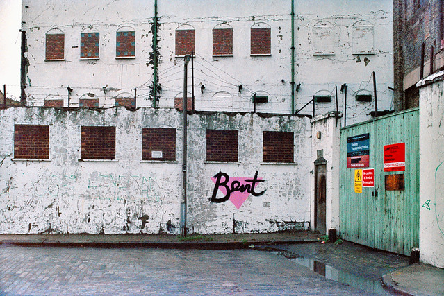
H W Bush, Mill Place, Limehouse, Tower Hamlets, 1990, 90-1c-16
Island Row, Mill Place, Limehouse, Tower Hamlets, 1990, 90-1f-66
Taken from near to the end of Island Row. But my walk was coming to an end. I made only one more black and white picture, not yet digitised, of the Regents Canal Lock from Commercial Road on my way to Limehouse station.
But I had also carried a second camera body loaded with colour negative film and I made the occasional colour picture during the walk. Here are four of them:
West India Dock Road & Limehouse Cut: My walk in Limehouse on Sunday 6th January 1990 continued. The previous post from this walk is Garford Street Limehouse – 1990. As usual you can click on the images here (except the panorama) to view larger versions on my Flickr pages.
Shops, West India Dock Road, Limehouse, Tower Hamlets, 1990, 90-1c-42
This area is close to the parish border of Limehouse and Poplar, but in popular imagination was certainly Limehouse, London’s first ‘Chinatown’. But by 1990 Chinatown had almost entirely moved to Soho, though a few elements remained, including the Peking Restaurant – though a few shops down the street is the Poplar Fish Bar.
Davey & Co, 88, West India Dock Road, Limehouse, Tower Hamlets, 1990, 90-1c-43
“In February 1885 Arthur Christopher Davey began a venture that throughout the 20th century evolved into a culture in the manufacture and supply of marine equipment. From humble beginnings in Leadenhall Street, the company soon moved to its famous address at 88, West India Dock Road, London E14, where it successfully traded for over 100 years.” The company is now based in Colchester.
Shops, West India Dock Road, Limehouse, Tower Hamlets, 1990, 90-1c-45
The Wah Ying Restaurant was another remanant of Chinatown – and you can see along the road the sign of the Peking Restaurant. In the distance are the warehouses of the West India Docks and beyond them the cranes building Cabot Square at Canary Wharf.
West India Dock Road was laid out at the same time as the West India Docks opened in 1802, a new road to give access to them, which was for many years a toll road. I think these buildings probably date from the 1870s or a little later after the tolls were removed.
The restaurant looks very much closed and the broken windows above suggest it was empty and derelict when I made this picture.
The Limehouse Cut runs on a straight route through Poplar but curves around at its southern end. It was blocked here in 1990, possibly in connection with the building of the Limehouse Link tunnel between 1989 and 1993. But there was also work on the Cut around then, with the vertical guillotine gate on the north side of Britannia Bridge across the Commercial Road being removed.
The tower of Hawksmoor’s St Annes Limeouse seen above the viaduct built for the London and Blackwall Railway and opened in July 1840, the second or third railway viaduct to be built in London, after the 1836 London to Greenwich viaduct and the the Hanwell viaduct, technically then outside London. The line went to Brunswick Wharf in Blackwall where passengers could board ferries and boats to other destinations down river or around the world.
I can tell you nothing more about Poplar Mods except that the graffiti tells us they are male “Hammers” fans. West Ham began life as a team for the workers of the last remaining shipbuilders in the area not far away on Bow Creek as the Thames Ironworks Football Club. From 1895 they played at Hermit Road in Canning Town, former home to Old Castle Swifts, Essex’s first professional team which had gone bankrupt, They became West Ham United in 1900 and moved to Plaistow, before in 2004 uniting with the Boleyn Castle football club and moving to their Upton Park ground where they stayed until 2016.
I think the next few pictures I made were taken from the block of flats immediately to the east of Limehouse Cut, Kiln Court, a medium rise block built as part of the Barley Mow Estate for the GLC in 1965-8. Back in 1990 many blocks still did not have security doors and it was possible to easily access shared areas.
Here you can see the Cut and the DLR viaduct across the north side of Limehouse Dock with its bridge and the Roman Catholic Church of Our Lady Immaculate & St Frederick on the corner of Island Row and Commercial Road.
I think the buildings on the far bank of Limehouse Cut were temporary offices and accommodation for the building of the Limehouse Link tunnel. The site is now occupied by housing at the end of Island Row.
In this picture you can see across to Limehouse Dock with the Hydraulic Accumulator Tower next to the DLR viaduct at the right. At the left is the temporary blockage on the Limehouse Link.
Sliding my shift lens to the left gave a view a little further towards the south and shows a little more of the Cut past the blockage and in the distance a small glimpse of the River Thames. This image was taken to create a panorama together with 90-1c-23:
Garford Street Limehouse: My walk in Limehouse on Sunday 6th January 1990 continued. The previous post from this walk is Around Emmett Street, Limehouse 1990. As usual you can click on the images here to view larger versions on my Flickr pages.
Garford Street is variously described as in Limehouse, Westferry and Poplar, although estate agents seem to prefer Canary Wharf, which is certainly isn’t, though fairly close by. Back in 1990 I think most of us thought it was Limehouse.
The 1994 LCC Survey of London deals with it in a chapter Limehouse Hole: The inland area. This tells us that a John Garford in the early 19th century had a wharf on the Thames at its western end on Emmett Street. Since the building of the Limehouse Link tunnel and the new route of Westferry Road for the Canary Wharf redevelopment it now starts around 200 yards to the east on Westferry Road. Its other end is still at the West India Dock Road.
I think the junction here is a part of the lost area on the north side of Garford Street. The chimney in the background is a remnant of the Lion Works, established here in “1896-7 by James Walker & Company, steam packing makers,” later Lion Packings Ltd who made “Patent metallic packing” here until around 1926. “The site was cleared for public housing in 1938–9” but as you can see the chimney survived until 1990.
Another view just a few yards from the previous image shows some large cable drums from AEI Gravesend. A notice tells those waiting for MOT tests at the Austin Rover garage where to queue.
This derelict warehouse building still has the remains of a hoist to the first floor entrance above its main door. There is now new housing on this site just to the west of the DLR railway bridge on the north side of the street.
Greig House, Garford St, Limehouse, Tower Hamlets, 1990, Built 1902-3 as accommodation for officers from Scandinavian ships docked in London it was taken over in 1930 as a Salvation Army hostel, and later used to house male alcoholics and more recently as a residential detoxification centre for men and women with drug or alcohol problems. Grade II listed along with the cottages on Garford St.
A second view of Greig House which shows some of the buildings of the West India Dock on Hertsmere Road in the background as well as the cranes building parts of Canary Wharf around Cabot Square. You can read much more about this and the associated buildings on the Lost Hospitals of London site.
From here I walked across the West India Dock Road in Poplar where my next post on this walk will begin.
Around Emmett Street, Limehouse: My walk in Limehouse on Sunday 6th January 1990 continued. The previous post from this walk is Three Colt Street & Limekiln Dock – 1990.
You won’t find Emmett Street on a map of Limehouse now. It ran from the southern end of Three Colt Street to meet West Ferry Road a few yards to the north of the Limehouse Entrance and Limehouse Basin the the West India Docks. Along its west side were a number of wharves – Taylor’s Wharf, Aberdeen Wharf, River Plate Wharf etc, the dry docks of Limekiln Dockyard and Limehouse Dry Dock and a dock at Aberdeen Wharf. This area was Limehouse Hole and included Limehouse Stairs from which a ferry once ran to Rotherhithe from what later became called Limehouse Pier.
Dundee Wharf, Aberdeen Wharf and the River Plate Wharf were were all part of the Dunbar Wharves. They ran regular twice weekly services to Scotland as well as importing goods from around the world – including meat from Argentina, and Oxo cubes were at one time wrapped here.
Emmett Street had at some time been known as Limekiln Hill – and West Ferry Road was earlier Bridge Road. These names were still used on the 1870 OS map, although The Survey of London says it was known as Emmett Street about 1830.
The land in this area was owned by the Emmett family who began selling it off in 1809 but their name remained on the street until it was completely obliterated with the building of the Limehouse Link Tunnel shortly after I made these pictures.
Much of the area had been cleared earlier by wartime bombing and the some large warehouses were rebuilt in the following years. The remaining 1870s warehouses were demolished in 1971-2 and the rest destroyed for the building of the road tunnel and Canary Riverside including Westferry Circus. You can read a detailed and well-illustrated article Limehouse Hole by Mick Lemmerman on the Isle of Dogs web Site.
Datakeep set out to provide secure storage for computer backup tapes in the largest warehouse in the area, formerly use for tea and coffee. The company later stored all kinds of things, including a 1935 vintage Bentley and offered a wide range of services to companies for their stored items.
Three Colt Street & Limekiln Dock: My walk in Limehouse on Sunday 6th January 1990 continued. The previous post from this walk is More from Narrow Street – 1990.
Limehouse gets its name from the making of quicklime here, an industry dating back here into antiquity getting its first written reference in 1335. The newly developed flats of Limekiln Wharf and Dundee Wharf on the south side of Limekiln Creek (or Limekiln Dock) are probably on the site of old lime kilns (lime oasts) where chalk (calcium carbonate) brought by boats from Swanscombe or Northfleet or other areas of North Kent was brought ashore in the Creek and roasted to give quicklime (calcium oxide) the vital ingredient for cement, mortar and concrete and with many other uses. When water is then added it forms slaked lime (calcium hydroxide.)
Along the street are the late-Victorian buildings of the Dundee, Perth, and London Shipping Co. which were used by the London Docklands Development Corporation which was responsible for the redevelopment of docklands, over-riding the normal functions of the local authorities and still have the LDDC logo as a weathercock, though this was not in place in 1990.
Limekiln Dock, Three Colt St, Limehouse, Tower Hamlets, 1990, 90-1b-36
The always interesting ‘A London Inheritance‘ has a fascinating and very detailed account of the area, based on considerable research, Limekiln Dock and the Black Ditch.
The Black Ditch has been much mythologised as one of ‘London’s Lost Rivers‘ and its lower parts were after the 1855 replaced by the Limekiln Dock Sewer. I imagine the Black Ditch and this were both subsumed into Bazalgette’s grand designs in the 1860s and now flow to Beckton.
The view here is looking out towards the River Thames. Since 1996 there has been a swing bridge taking the Thames Path across the mouth of the creek. It had to be built as a swing bridge because of the ancient rights of navigation into the dock, though I would be surprised to find that it has ever needed to be swung to allow this.
Limekiln Dock, Three Colt St, Limehouse, Tower Hamlets, 1990, 90-1b-25
There seemed to be quite a lot of rubbish in the dock in 1990, but in earlier years things were much worse. The post in ‘A London Inheritance’ quotes a court case from 1893 where it is described as “the common receptacle for the sewerage of part of Fore-street, and also being a harbour for a large portion of the animal refuse of the Thames.”
J R Wilson, Ship Stores, Limekiln Dock, Three Colt St, Limehouse, Tower Hamlets, 1990, 90-1b-26
J R Wilson, Ship Stores at Limehouse Wharf has a frontage on Narrow Street and its back faces Limekiln Dock. I think the area from which I took this and the other pictures is no longer open to the public, but gave access to the Thames Path before the footbridge across the dock was built. In the foreground is the white-painted flood wall which was built around the Thames in London in the 1970s. Together with the Thames Barrier this has protected London from the serious floods of earlier years, but with rising sea levels will soon become inadequate.
110, Three Colt St, Limehouse, Tower Hamlets, 1990, 90-1b-11
The late-Victorian buildings of the Dundee, Perth, and London Shipping Co were in 1990 in use by D D Repro Limited, ‘Plain Paper & Dyeline Specialists. Their board on the building depicts the rough outline of the Thames from Tower Bridge around the Isle of Dogs and on to Beckton.
The Enterprise, pub, Milligan St, 145, Three Colt St, Limehouse, Tower Hamlets, 1990, 90-1b-12
The sign on the pub shows a three-masted ship caught in ice. The ships on Sir John Franklin’s doomed 1845 search for the North-West Passage were last seen by the whaler ‘Enterprise’, and I think this picture may be a depiction of one of his two ships, which were abandoned after being ice-bound for over a year. It was a story that very much caught the Victorian imagination.
The pub is said to have closed in 1963, but was open again in 1990, It closed in 2001, the pub became an Indian restaurant but is now an estate agents with another floor added in recent years.
Still more to come from my Limehouse walk in 1990.
More from Narrow Street – 1990: My walk in Limehouse on Sunday 6th January 1990 continued. The previous post from this walk is Around Narrow Street, Limehouse – 1990
It was hard not to take picture after picture on Narrow Street, particularly as I was aware much was soon to disappear, and I made over 20 exposures, though I’ve digitised less than half of these, and I’ll only post a few of these as some of the others are rather similar or at least overlap in terms of subject. This view shows some of the same buildings from the picture that ended the previous post, but from a slightly different viewpoint. Most including all in this view ,were demolished shortly afterwards.
My previous post told the story of Duncan Dunbar and his son of the same name who built up a huge shipping empire based around Dunbar Wharf but sold off at his death in 1862. The four warehouses at 136, 136½, 138, 140 were Grade II listed in 1973 and some at least were still in various commercial use back in 1990.
Until the 1970s it was a working wharf – E W Taylor, a lighterage company had begun using it for oversize cargo in 1857 – and the company also “became experts in the warehousing and fumigation of the botanicals used in making gin.” The company, now part of Dunbar Wharf Holdings Limited, acquired Dunbar Wharf in the 1940s.
All the remaining properties in Dunbar Wharf have now been converted into flats and you can read online about the 2020 renovation of one of the 1790s warehouse buildings into “a beautiful residence by the Thames.”
Barlow and Sons Auto Repairs were at 144 Narrow Street and offered their auto repairs with the aid of some really king-size spanners. This building was replaced in 1997 by Creek House.
These buildings were demolished shortly after I made these photographs for the development of the Limehouse Link tunnel and were then replaced by modern flats with a vaguely pastiche frontage. Their demolition enabled archaeological investigation of the site of Joseph Wilson and Company’s Limehouse Porcelain Manufactory operating here from 1745-8.
St Dunstan’s Wharf, Narrow St, Limehouse, Tower Hamlets, 1990, 90-1b-44
St Dunstan’s Wharf at 142 Narrow Street is also Grade II listed and has survived. Together with the listed buildings of Dunbar Wharf it backs onto Limekiln Dock. Above the doorway is its name and a floral decoration together with what appears to be a large pair of blacksmiths’ tongs, the pincers used by St Dunstan to grab the together with another tool I don’t recognise.
Along is bottom are the initials W & G.G and the date 1878. Gardner & Gardner, hay & straw salesmen, are listed at this address as well as in Spread Eagle Yard in Whitechapel High Street. The listing text states this is on a metal plate, but it looks more like terracotta in my picture. Apparently the building was also used as a store for materials including juniper berries and flowers used to make gin.
I was more or less at the end of Narrow Street and my walk will continue along Three Colt Street in another post.
From Northey Street I turned right into Brightlingsea Place, another street name still there in Limehouse although little of its buildings remain. The exception is Faraday House, a five storey block built by Stepney Borough Council in 1931 as a part of their Limehouse Fields slum clearance scheme. Much of the area to the east was also destroyed in the war, apparently by a V2 rocket and was finally cleared and excavated for the Limehouse Link Tunnel. It is now a public park, Ropemakers Field.
On the west side of Brightlingsea Place was the Limehouse Power Station (also known as Stepney Power station) built in 1907, decommissioned in 1972 and demolished.
Parts of the power station were still in place in 1990 and a notice on the gates at right confirm this is Stepney Transforming Station and warn of the danger of 66,000 volts. But Stepney – and Limehouse – was now undergoing a very different transformation.
The House They Left Behind, Ropemakers Fields, Narrow Street, Limehouse, Tower Hamlets, 1990, 90-1a-24
The pub, The House They Left Behind, at the entrance to the cleared area between Brightlinsea Place and Ropemakers Fields a few yards north of Narrow Street was indeed the only building left standing in this area. At 27 Ropemaker’s Fields built in 1857 it had previously been called The Black Horse and was on the edge of the Barley Mow Brewery Site. After several further name changes and becoming a bar/restaurant it closed around 2010 and is now residential.
An Instagram post by londondeadpubs tells the interesting story of the stabbing there in 1998 of “Christopher Dunhill, heir to the vast Dunhill tobacco (and, weirdly, cufflinks) fortune” who was then a resident there and “helping out at the oyster bar“. He had earlier in 1987 been convicted of drug dealing but somehow only served 15 months in prison and “today he appears to be CEO of a Bahamian financial company.” But do read the full post.
To the east are these tower blocks of the Barley Mow Estate on Oak Lane, seen here from Ropemakers Fields. These blocks were built on the Barley Mow Brewery site and were built around 1967 for the London County Council using the same “Large Panel System” which failed in the Ronan Point disaster in 1968.
Reports led to additional strengthening work on Brewster and Malting House, but it was decided to demolish Risby House as it would be adversely affected by the contruction of the Limehouse Link Tunnel.
This was one of the best-known lighterage firms on the river until the business was closed down in 1973 by ‘Dolly’ Fisher on her 79th birthday. In its heyday had around a hundred barges on and nine tugs on the river.
Dorothea Woodward Fisher and her husband William, a lighterman who she had married over the protests of her family had formed the company with only £20 and one barge. And when her husband died in the 1960s she took over the running of it – and was described by many on the river and in a 1972 BBC documentary as ‘Mother Thames‘.
Dunbar Wharf on Narrow Street backs onto Limekiln Dock. Duncan Dunbar came to Limehouse from Scotland and made a fortune as a brewer and wine merchant, leaving his son – also Duncan Dunbar – sufficient to found a shipping business in 1827. By 1842 he had 11 ships and in the next 20 years ordered another 42.
As well as trading in various goods iuncluding wine and spirits, Dunbar’s ship’s made 37 voyages taking convicts to Australia and were troop carriers for the Crimean War. When he died in 1862 his estate was worth £2 million. His family then sold up all of the business. Apparently one of his former ships, the Edwin Fox is a museum attraction in New Zealand.
Limehouse Basin and Limehouse Cut: More pictures from my walk around Limehouse on on 6th January 1990. The previous post from this walk is Ratcliff Highway and Limehouse Basin – 1990.
The Limehouse Cut is London’s oldest canal, opened in 1770 to provide an easier route from the Lea Navigation, an important river for transporting grain into London from the agricultural areas to north in Hertfordshire. Used from the Bronze age and later by Viking raiders, alterations had been made to improve navigation on the River Lee since at least 1190 and was later followed by various Acts of Parliament. The first river lock in England was built on it at Waltham Abbey in 1577, but it was only the the River Lee Navigation Act 1767 that really began its modernisation.
Part of the work made under the 1767 Act when the navigation was surveyed John Smeaton was the suggestion to dig of the Limehouse Cut, allowing boats to avoid the treacherous and winding tidal lower reaches of Bow Creek on their way to the River Thames. The actual surveyor when the work began was his assistant Thomas Yeoman. It was a considerable short cut as it emerged into the river to the west of the long haul around the Isle of Dogs.
The original canal was narrow and had to be later widened and improved and it was only in the Victorian era that it was finally in something like its final state. The canal until 1968 entered directly into the Thames though Limehouse Lock in front of the row of small houses in these pictures, but it also had a basin, Limehouse Basin, at its southern end.
The first Limehouse Basin was at first simply a basin at the end of the Limehouse Cut, dug out by 1795. It had an island in it and on its bank was a a sawmill driven by a windmill, built a little earlier when sawmills were still widely thought to be illegal in England. It was attacked and the machinery destroyed by rioters – including hand-sawyers – in 1768. Restored the following year it closed around 35 years later. A lead mill opened on the island soon after and the company only ceased to exist in 1982. Victory Place is built on the site of this original Basin, and the old streets Island Row and Mill Place to its north are still there.
The Limehouse Cut was in 1854 linked to the Limehouse Basin of the Regent’s Canal which had opened in 1820 as the Limehouse Lock needed to be repaired. But this link was opposed by the boatmen from the Lee and Stort who fought a legal battle and in 1864 it was filled in and the site built on. It was not until over a hundred years later in 1968 that a new link – only 200 metres long – was made and Limehouse Lock finally closed.
The Limehouse Cut runs on a straight route through Poplar but curves around at its sourthern end. It was blocked here in 1990, probably in connection with the buildilng of the Limehouse Link tunnel between 1989 and 1993. But there was also work on the Cut around then, with the vertical guillotine gate on the north side of Britannia Bridge across the Commercial Road being removed.
Northey Street still has a bridge over the remains of the old route of the Limehouse Cut to Limehouse Lock, but all of the buildings including wharves and works on the banks of the Cut have now been replaced by modern development. The tower blocks beyond are on Oak Lane, and I think in the distance are cranes working on developments on the Isle of Dogs around Canary Wharf.
Ratcliff Highway and Limehouse Basin: My first photographic walk in 1990 came at the end of the Christmas and New Year season on 6th January 1990 when I returned to Limehouse for another walk. I’d taken quite a few pictures there back in 1984 and I thought it was time for another extensive visit. Getting there was easier now that the DLR ran to Limehouse. I left the station and walked down Branch Road.
Obviously not built as a Scout HQ, but something rather more official, and this was built in 1898 as the Stepney Borough Coroner’s Court.
Branch Road was apparently earlier called Horseferry Branch Road and led to a ferry across the Thames here – and Branch Road still leads to a road called Horseferry Rd. An ancient ferry ran from Ratcliff Cross Stairs and would have taken horses and carts as well as people across to Rotherhithe. You can still go down to the foreshore here from Narrow Street down the Grade II listed stairs but of course there is no ferry. The listing is probably more for the historic interest of the site – the stairs themselves are are relatively modern concrete replacement and the ancient causeway here apparently disappeared around 2000.
Tubular Barriers, The Queens Head, The Highway, Limehouse, Tower Hamlets, 1990, 89-12d-34
At 491 The Highway – formerly known as Ratcliffe Highway – close to the corner with Butcher Row – the Queens Head pub to the right of this view – was demolished soon after I made this picture in 1990, along with the rest of these buildings. At the left is a sign for the Limehouse Link tunnel, built between 1989 and 1993 and I think this was a storage yard for the work. The western end of the tunnel is a short distance to the east.
Another part of the Tubular Barriers site on The Highway which I think I photographed mainly for the graffiti ‘ELECTROCUTE MURDOCH’ on its wall. I think this was at the corner with Butcher Row. Though the company name also made me think of the Mike Oldfield album Tubular Bells.
There had been a particularly bitter and hard fought (sometimes literally) fight over the opening of Murdoch’s News International print works at Wapping in 1986, following the dismissal of all 6000 of the print workers at the previous Fleet Street hot metal print plant.
Works, 503-9, The Highway, Limehouse, Tower Hamlets, 1990, 89-12d-25
Control of the development of the Docklands areas was in 1981 taken away from the local authorities and given to the London Docklands Development Corporation (LDDC) a quango agency set up by Margaret Thatcher’s Secretary of State for the Environment, Michael Heseltine. Although this resulted in a faster regeneration of the area this was largely driven by the interests of global capital and often went against the interests and needs of the local communities. This whole area was demolished around 1990. I did wonder if the three-storey building might be a former pub.
Works, 503-9, The Highway, Limehouse, Tower Hamlets, 1990, 89-12d-12
Notices on the shop-front at right read
‘DOCKLANDS LOCAL PLUMBERS & ELECTRICIANS
CAN THE LDDC LEGALLY STEAL OUR LAND? 57 MEN TO LOSE THEIR JOBS’
The LDDC had wide ranging powers and legalised thefts such as this. It was an area in need of redevelopment and the LDDC got this moving at pace, but it would have been far better to have found ways to retain former businesses and provide more social housing and other community assets.
Considerable building work was taking place around the lock linking Limehouse Basin to the River Thames.
This is the ship lock and there had once been two narrower barge locks a short distance west. The ship lock was built slantwise to make for and easier entry by larger ships (up to 2000 tons) from the river and was a part of its enlargement in 1869. The lock had two compartments with three gates. In 1990 the outer gates to the Thames were still in place (in pictures not yet digitised) but no longer in use and the other two replaced by this much narrower single lock, suitable for the smaller vessels now using the Basin as a Marina.
A building for Limehouse Waterside and Marina on the corner of the 1869 Ship Lock and Limehouse Basin. Running across on the opposite side of the water is London’s third oldest railway viaduct, built in 1840 for the London and Blackwall Railway and now in use for the DLR.
I wrote this post some months ago but when I tried to publish it none of the pictures appeared. They seem to be working now, though I’m keeping my fingers crossed.
Poor Little Overlooked Images: I’m often asked “Is it worth putting images on Flickr?” My answer is it depends on why you take pictures, what you photograph and what you expect to get out of it.
Ionic Temple, lake and obelisk, Chiswick House Gardens, Chiswick, 1977 10c103
To state what I think is obvious, I don’t make a living out of Flickr, though I do get the occasional sale because people have found my pictures through it. It’s actually getting a little embarrassing now, as I shut down my business after Covid and I think I’m going to have to re-open it due to increasing sales.
Cheshire St, Tower Hamlets, 86-4r-23
But what I’ve always wanted to do is to share my images with other people, and Flickr is certainly doing that. When I was writing this some months ago there were over 45,000 views of my pictures on Flickr in a single day, and many days there are over 10,000 views. In total I’ve now had over 15 million views of my pictures there.
Brick Lane, Tower Hamlets 86-4r-11
Of course it isn’t the same as a gallery show, but most of those I’ve taken part in over the years have been lucky to get 100 visitors coming to view them in a day. So Flickr can get your work seen, and seen by a very much wider range of people than are interested enough to go into a gallery to see photographs.
Collegiale Notre-Dame de la Crypte, Cassel, France
Though I have to say that some of those people see very different things in the pictures than what interested me and what I was trying to say when I made the picture.
D933, France
I don’t mind this. Sometimes they give me information about the scene which I was totally unaware of – and occasionally it adds something to my appreciation. Often I get comments which are very personal to the viewers who may have lived or worked in somewhere that I photographed and it perhaps adds another layer to my view of the image, as well as being pleasing that they found it of interest.
Notting Hill Carnival, 1999. Peter Marshall 99-823-11_2400
But there are some things I don’t like. People who share my images on social media without naming me as the photographer is perhaps the top of the list, and if anyone should dare to colorize one of my black and white images I might to moved to take out a contract on them. So far as I’m aware it hasn’t happened yet.
St Omer, France
But while my most viewed images have been seen over 20,000 times (one now 35,699 views) there are also a few which have apparently never been viewed at all.
St Omer, France
They aren’t any worse than most of my other pictures – and in any case how would anyone know without viewing them. I think it may actually reflect some small glitches in Flickr’s recording of views, as when I click on them in the Flickr report it actually states “No recent stats available for this photo” and I’m fairly sure some at least will have been seen by some people.
St Omer, France
But here, illustrating this post. are some of the fifteen images which had apparently never been seen when I wrote this post a few months ago. And after writing I discovered why – Flickr had changed their privacy settings to private. Not me – all of my images are uploaded as public. Somehow a stray bit or byte in their database had flipped. I’ve just checked again and found a different half-dozen images hidden in the same way.
Flickr has a reasonable search facility (though occasionally it goes haywire) and almost all of my images are keyworded. If you want to know if I have taken a picture of your street or town – or anything else – simply click this link to Flickr and type my name followed by what you want to find in the search box at the top of the page.
So to find if I have photographed Pegasus simply type:
Peter Marshall Pegasus
into the search box – and it should find all seven. Londoners in particular may find it useful to search on the names of London boroughs in this way.