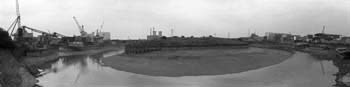
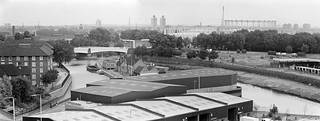
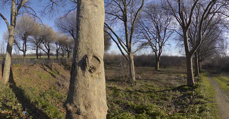
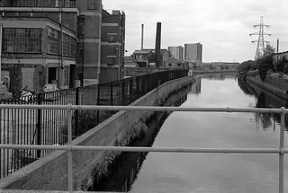
Standing more or less on the bank of Bow Creek beside the saw mill in 1983 I could see the elevated East India Dock Rd from which quite a few of my pictures were taken, and beyond it the box-like West Ham Power Station with its two pencil-like chimneys and cooling towers. Sawing timber creates a great deal of dust and a large extractor removes this, probably more for its commercial value than an anti-pollution measure.
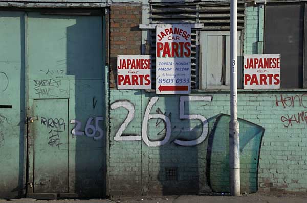
Looking down from East India Dock Rd onto the circular car park where Wharfedale Rd emerged from the tunnel under the road. There were few if any traces of the old railway line that used to run between the fence and the river here – where the DLR now runs. The picture gives a good impression of the densely packed industry on the peninsula beyond the creek. Taken with an extreme wide-angle lens – the 21mm on the Olympus OM1 you can see some stretching of objects closer to the edges of the frame which is a consequence of rectilinear perspective.
Working from more or less the same position (but on a different day) with a less wide lens (probably a 35mm) gives a considerably less wide view, making distant objects seem larger, and also avoids any noticeable distortion. You can see the flood barrier on Bow Creek much more clearly.
Moving a little further along East India Dock Road gave a better view of the river now running south through the flood barrier. At left are the tower blocks of Canning Town. The row of buildings at right are on the far side of Victoria Road, and the railway line from Stratford to North Woolwich is in front of them, hidden by a bank of earth. Stairs led down from the road to this waste land and there were no fences to stop me walking along the river bank.
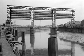
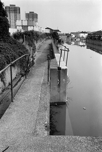
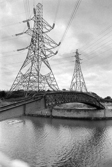
From the bank I got a good view of the flood barrier, its three gates in raised position, getting shorter from left to right to match the slope of the creek, deeper on the outside of the curve. Building the Thames Barrier at Charlton which first came into operation at more or less at the time I made this picture made this barrier, previously essential to prevent flooding along Bow Creek, redundant. It was removed shortly after I made these pictures.
Back in 1983 there were no barriers to stop me walking beside Bow Creek all the way to the River Thames, but not long afterwards this whole bank was closed off to the public. There have long been plans to open part of it as a riverside walkway, with the northern part of it built but fenced off, and in 2004 following a public competition a winning design was selected for a bridge further downstream a little below the Lower Lea Crossing across the river as a part of this foot and cycle path to Trinity Buoy Wharf. But in 2005 the Thames Gateway Delivery Unit withdrew funding and the bridge was never built. The last time I visited the area a couple of years ago the riverside walkway was open but ended around a hundred yards south of Canning Town station.
There is now a bridge across close to Canning Town station leading to the development of City Island which has replaced the edible oil factory on the peninsula which opened in 2014, though a far less interesting design than the competition winner.
The empty area to the east of Bow Creek which can be seen in some of these pictures was from 1837 to 1912 the home of the Thames Ironworks and Shipbuilding Company Ltd. More recently it was for some years given over to a construction works yard for Cross Rail and is now home to the Limmo Peninsula, a largely residential development scheme by a partnership between TfL and Grainger plc.
You can visit my Flickr album with more pictures of the area by clicking on any of the pictures above which will take you to a larger version from where you can explore the album. Future posts will look at a series of panoramic pictures I made in 1992 and continuing my walk to the Thames.
All photographs on this and my other sites, unless otherwise stated, are taken by and copyright of Peter Marshall, and are available for reproduction or can be bought as prints.
Goiong down Leamouth Road roughly south and parallel to the river there were a few places where you could look back up to the East India Dock Road and the disused railway bridge that crossed the creek a little to the south of the road. The bridge had carried a line which came from where Canning Town Station now is along the route now followed by the DLR but continuing across the river to pepper warehouses for the East India Docks opposite the docks on the eastern side of Leamouth Road, still shown on my 1939 Philip’s A B C Pocket Atlas-Guide to London and its Outer Districts.
Where the river swung around the Limmo Peninsula – now the Bow Creek Ecology Park – the view was wide open with the river only separated from the road by an open fence. Close to the bend to the west was Orchard Wharf, where J J Prior were still carrying out ship repairs. The flats in the background are on the other side of the East India Dock Road.
Looking up the creek on the eastern side of the peninisula was the west bank of the second peninsula, occupied by a large edible oil factory, Pura Foods, the smells from which were often rather noticeable. There were local campaigns to have this factory shut down, and eventually it did move out, relocating a few miles down-river. This peninsula is now redeveloped as City Island.
Roads in this area were disrupted when the Lower Lea Crossing was built – it opened in 1991. When I first went to photograph the area, Leamouth Road (historically called Orchard St) continued to meet Orchard Place at a T-junction, with Orchard Place going north to the Pura Food site and south, then turning east to Trinity Buoy Wharf.
Although there were still high walls along the northern section of Leamouth Rd, there was a clear view of Bow Creek looking south from the East India Dock Road only around a hundred yards east of where the river, here flowing roughly north, went under the bridge in the opposite direction.
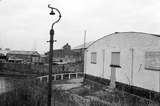
Wharfside Road comes in a short tunnel under the East India Dock Road on which I was standing to take this picture, leading to Essex Wharf and the saw mills for the timber yard. The Docklands Light Railway now runs along here on the route of the the former rail line to the pepper warehouses, just in front of the line of parked cars in this picture.
There is now a footbridge across the DLR leading to a riverside path, built at around the same time as the new railway, the gates to the bridge were kept locked for most of its first twenty years but now seem to be permanently opened, and it provides a good short cut to Canning Town Station, whose riverside entrance was also locked for years after it was built, as well as to a new footbridge to City Island which replaced the factory here. You can also now walk or cycle down here to the right to visit the Bow Creek Ecology Park. Although very different it is still an interesting area in which to walk.
Clicking on any of the above images will take you to larger versions in my Flickr album on the River Lea. A further post will start at Wharfside Road and look at my pictures moving along Bow Creek towards the Thames.
All photographs on this and my other sites, unless otherwise stated, are taken by and copyright of Peter Marshall, and are available for reproduction or can be bought as prints.
It was back in July 1982 I took my first walk down Leamouth Road, where there were still high walls for the closed East India Docks and some wharves on Bow Creek were still in use, their walls and sheds hiding the river from view. But at the southern end, where the river swung around a 180 degree bend, the view opened up, with only a fence and a couple of feet of weed-covered earth between the pavement and the river wall. It was getting late and I had to rush away, but I had seen a view that I could not do justice too with even my widest lens, a 21mm f3.5 Zuiko.
The fence was old and rusty, and one short section had broken, and on my return in August I made my way through the gap with my hefty Manfrotto tripod. There wasn’t enough space to set it up properly with the legs fully extended and opened, but after a bit of a struggle I managed to get it level. I checked it with the separate spirit level I carried in my camera bag, then put my Olympus OM1 in place and checked with the level again.
It was a slow business, and I was just a little worried that someone might come along and question what I was doing, though rather more worried that I might fall over the low wall onto the muddy shingle perhaps 6ft below.
I think the lens I used was probably the 35mm f2.8 shift, though at its central non-shifted position, and I tried to position its nodal point roughly above the axis of rotation, though it was not too critical here as only the first and final exposures would include any near detail.
I then began a series of six exposures, swinging the camera on the tripod roughly 30 degrees between each exposure (the tripod has a scale in degrees) using the handle on the pan and tilt head. All went well until the last of six exposures, though it was a little tricky working in a rather confined space, and I needed to move away from where I had been crouching to the right of the tripod so as not to be in the picture.
It wasn’t a tragedy as I squeezed between the tripod and the fence, and I managed not to knock the whole set-up into the creek, but I did knock it a little out of place, and while the first five exposures have the horizon almost exactly level, the sixth was perhaps ten degrees askew.
Of course I took a replacement, and it was only after I’d printed it that I found it wasn’t quite an exact fit, and when I carefully cut and pasted the six prints to make a single panoramic image the difference showed, at least to me. So instead I put the images, cropped slightly to reduce the overlap, into a row of images with a margin between each of them. More recently of course I’ve been able to scan the images and combine the digital files, and it more or less works, but ends up with a very long thin panorama that doesn’t work well on screen.
A few years later I returned with a panoramic camera and made a very different picture just a few yards away, but the original scene had changed dramatically.
Clicking on any of the larger pictures in this post will take you to a larger version in my Flickr album, from where you can explore other pictures of Bow Creek.
All photographs on this and my other sites, unless otherwise stated, are taken by and copyright of Peter Marshall, and are available for reproduction or can be bought as prints.
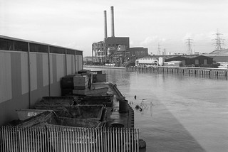
Bow Creek, West Ham Power Station, East India Dock Rd, Tower Hamlets, Newham, 1989
Bow Creek truly became magical as it passed under the East India Dock Road, and although it has now lost much of the interest on its banks, the incredible flattened S-shape as it curves before reaching the Thames remains impressive.
Bow Creek, West Ham Power Station, East India Dock Rd, Newham, 1989
The creek bends almost 90 degrees to flow roughly south under the road at Ironbridge Wharf (the iron bridge long replaces by more modern concrete structures) only to take a hairpin 180 degree bend to return almost back to the road before sweeping another 180 degrees down to go over the elevated Lower Lea Crossing. From there its convolutions continue with a 90 turn to the east and another to the south before entering the Thames as Leamouth, around 900 metres away as the gull flies, but 1900 by boat.
Bow Creek, East India Dock Rd, Poplar, Tower Hamlets, Newham, 1982
Its course defines two very different peninsulas; to the west on largely undeveloped and now a nature reserve, with the DLR crossing to it on a viaduct and running up it, and on the east an industrial site, then occupied by the edible oil company Pura Foods (earlier Acatos & Hutcheson) and now the site of the City Island development.
Timber yard, Essex Wharf, Bow Creek, East India Dock Rd, Newham, Tower Hamlets, 1989
On the eastern bank of the river south of Canning Town station is another so-called peninsula, the Limmo Penisula, which became a major Crossrail works site and is now a housing development. The name was previously used for the whole area around this part of Bow Creek and the nature reserve, now the Bow Creek ecology park was first called the Limmo Peninsula ecological park. It is an area of confusing names, with the new development south of the Lower Lea Crossing taking its name, Goodluck Hope, from the area now called City Island. It was also easy to get a little confused by the area itself with the wandering of the river, and even when writing this post I had problems sorting out pictures just from the appropriate area.
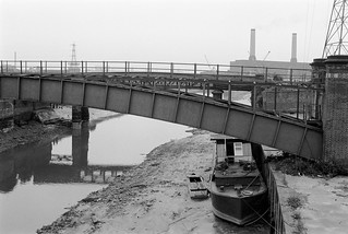
Pipe Bridge, Bow Creek, Tower Hamlets, Newham, 1989
The pipe bridge possibly carried gas from the nearby Poplar Gas works to Canning Town; downstream was a disused railway bridge. A new ‘blue bridge’ was later erected between these two (it appears in my 1992 pictures) and the pipe bridge was taken down though its brick piers left in place – now only the eastern one remains.
Timber Yard, Bow Creek, Tower Hamlets, 1989
The pictures in this post were all taken on or close to the East India Dock Road where it crosses Bow Creek, beginning with a couple looking up river and with the rest looking towards the south. In later posts I’ll cover the area further down Bow Creek which played an important part in the industrial (and footballing) history of the nation, and return with the creek back almost to the road.
Bow Creek, Leamouth Rd, Leamouth, Tower Hamlets, Newham, 1982
The pictures here are from visits to the area in 1982 and 1989, but I also took some in 1983, and returned again in 1992, mainly to make some panoramic views, which I’ll write about in a later post. You can see more of my pictures in my Flickr album – this area is on page 4 – and clicking on any of the above pictures will also take you to the larger version there.
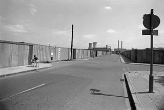
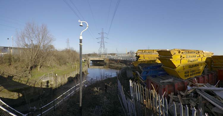
Back in the 1980s it wasn’t possible to walk beside Bow Creek from Bow Locks south to the East India Dock road, as the banks were occupied by various industrial and commercial sites, including two gas works and West Ham power station. And although there have been plans by the councils for many years, even today you can only walk down on the Newham bank as far as Cody Dock, on a path opened to the public some years ago with the ridiculous name of the Fatwalk, but since renamed. There is a tantalising walkway visible continuing past the dock along the former power station bank, but this is still closed to the public.
While this was a limitation, it was also an opportunity to explore the two areas where roads ran close (or not too close) to Bow Creek to both the east in West Ham and west in Bromley and Poplar, and I was rewarded by some images I found interesting, though parts of my walks were along fume laden streets with heavy traffic.
Tweed House, a tall block of council flats on the Blackwall Tunnel Approach Road next to the Limehouse Cut enabled me to take some pictures which I more recently stitched together to create two panoramas of the area – the individual pictures are also in the Flickr album. Click to see the larger versions on Flickr.
From various places both on to the east and west of Bow Creek I found rather satisfyingly bleak views of the distant power station, including one with a young mother with a small baby in a pram.
Others were emptier still, like this
or more minimal and just occasionally rather threatening; some streets around here featured in crime films and TV dramas of the era, gangster London.
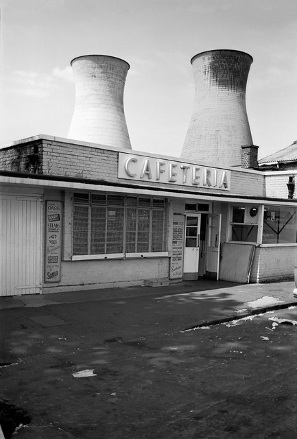
But there was also a little chance for fun, with a cafeteria with two giant cooling towers to take away the cooking fumes and the unlikely name of Oasis.
Poplar Gas Works was on a rather smaller scale to Bromley-by-Bow, but its gas holders still dominated the working class housing around it. Two young girls playing on the grass came to see what I was doing and insisted on being photographed, though I perhaps should have stepped back a foot or two to avoid cropping their feet to get the gasholder in the frame.
At East India Dock Road I was able to return to Bow Creek – and things got even more interesting (and although very different they still are) as I hope to show you in the next installment of my work from the Flick album River Lea – Lea Navigation – 1981-92 – the pictures above are all on Page 4.
Clicking on any of the images above should take you to a larger version on Flickr, and you can also go on to explore the album from there.
All photographs on this and my other sites, unless otherwise stated, are taken by and copyright of Peter Marshall, and are available for reproduction or can be bought as prints.
Back in 2005 many were still hoping that London would not win their bid to hold the Olympics, particularly those who lived in the area who could see how their lives would be disrupted by this huge event (though in the end it was far worse than they had imagined.)
One of many businesses on Carpenters Road
They also saw how it would impact on the longer term development of the area. Many planners warned how it would distort the proper planning of the area and its future; although investment in the area was welcome, much or most of it would be put into white elephants which would have little long-term utility.
Waterworks River and Old River Lea at Carpenters Lock
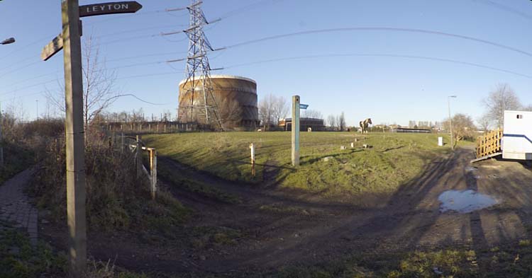
On Sunday 23 January 2005 I took my bike with me to Stratford and cycled to the meeting point at Temple Mills for a tour of the Olympic area with No to London 2012, a coalition of east london community groups and social justice campaigners.
Bully Point Nature Reserve
Around 20 of us then took a walk around the area, getting some informative comments at a number of locations. As I remarked in my write-up of the event in My London Diary:
It was an opportunity that IOC delegates are not likely to have, with their view of these particular areas expected to be with a pair of binoculars from a distant tower block.
I was already familiar with the area, having photographed around it since the 1980s, but still learnt a lot from some of those who spoke – and had just a little to add.
BMX track at Eastway Cycle Circuit is marked out
On our route around and also on my way to the meeting point I took the opportunity to take a few pictures, and after I’d sat down after the tour to eat my sandwiches by the Lea Navigation, to cycle to another area which was to be affected by the Olympics, Marsh Lane in Leyton, before making my way back to Stratford.
Wick Field, Hackney Wick
We were lucky with the weather, mild for January and with some sunshine, and I’d enjoyed the fairly short rides as well as the guided tour. I’d made several hundred pictures, including a number of panoramic images and felt I’d had a good day.
Leyton Marsh
Of course, London lost – and was condemned to host the Olympics. It was an event that caught the imagination of many of the public for the few weeks it was on, but has left a toxic legacy that will last decades.
You can see more of these pictures on My London Diary, where I’ve also written more about it.
All photographs on this and my other sites, unless otherwise stated, are taken by and copyright of Peter Marshall, and are available for reproduction or can be bought as prints.
St Thomas’s Creek, Cook’s Road, Stratford, Newham, 1983
There is and long seems to have been some confusion about the naming of this part of the canal system that links the main line of the Lea Navigation at Bow Bridge to the City Mill River and City Mill Lock. On some maps (including Google’s) it is simply referred to as ‘Bow Back Rivers’ but I find it less confusing to give it the more local name, St Thomas’s Creek, sometimes written as St Thomas Creek. The creek got its name from St. Thomas’s Mill, sometimes called ‘Pudding Mill’, I think because of its shape, which also gave its name to the small stream the Pudding Mill River and was actually on that stream on Pudding Mill Lane. For those interested there is a good map of the area before the flood relief works of 1931-5 on British History Online.
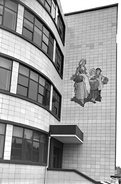
Warton House, former Yardley’s Box Factory, High St, Stratford, 1983
The earliest connection of the Yardley name to soap-making was in the first half of the 17th century, when a Yardley was given the concession to produce soap for the whole of London, but the company dated its founding as ‘Clever Brothers’ to 1770. This company making soaps and perfumes was taken over by William Yardley in 1823 and passed on to his son Charles when he died the following year. The company moved from Bloomsbury to a large factory on Carpenters Road Stratford in 1904 and bought land on Stratford High St in 1918. In 1913 they had trade-marked a picture by Francis Wheatley from his 1793 series, the ‘Cries of London’ to use in their advertising, replacing the primroses in his picture by lavender, and when they built a new art deco box factory in 1938 this was installed at a large scale on the building. Yardleys moved to Basildon in 1966, needing large premises, but in 1967 were taken over by British American Tobacco who sold the business to Beecham in 1985, who again sold it on after they merged to be SmithKlein Beecham. The company went into receivership in 1998. Parts of the box factory – including this section on the High St next to the Northern Outfall Sewer and the Waterworks River are still there, all that is left of Yardley’s in Stratford.
Stratford High St area, 1982
I cannot remember exactly where I took this or the next picture, though from other exposures on the same films both are clearly somewhere not far from Stratford High St. I think the canal seen at right here is probably St Thomas’s Creek.
Timber yard, Stratford High St area, 1982
Timber was the main product carried on the Lea Navigation in the later years of its use, and I think this timber yard was probably close to the main stream of the navigation. My attempts to find it again in later years were unsuccesful.
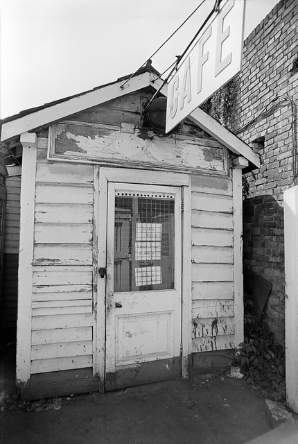
Cafe, Stratford market, Stratford, Newham, 1983
The notices on the door offer not just ‘Jellied Eels’ but ‘Best Jellied Eels’, along with ‘Loch Fine Kippers’. My contact sheet puts its location as Stratford Market in Burford Road, just off High St to the south.
Barges, Bow Bridge, October 1981
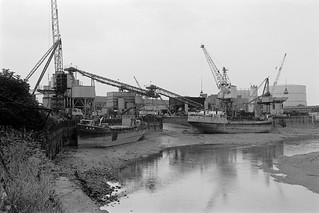
These last two pictures were some of the first I took in the area after I heard on a radio interview that commercial traffic on the Lea Navigation was to come to an end in a few weeks time.
I think it was the same day that I picked up my camera bag and got on the train to come to look for and photograph any remaining activity. It was a slow journey to Bromley-by-Bow from where I spent an hour or so walking along beside the navigation between Bow Locks and Bow Bridge, where I found three barges loaded with cut timber, photographing all three from the bridge and going down onto the wharf for another picture.
Barges, Bow Bridge, October 1981
I find it hard now to understand why I took so few pictures – only around 30 exposures on the entire visit, and just these two where I found evidence of any remaining commercial traffic.
All photographs on this and my other sites, unless otherwise stated, are taken by and copyright of Peter Marshall, and are available for reproduction or can be bought as prints.
City Mill Lock, Blaker Rd, Stratford Marsh, Stratford, Newham, 1990
City Mill Lock connected the tidal Waterworks River with the Bow Back Rivers which are a part of the Lea Navigation and thus at a constant level. There is another lock connecting the two systems further north where Carpenters Lock connects the Old River Lea to the start of the Waterworks River close to Carpenters Road. Both locks were built in the 1930s when considerable work was carried out, mainly to reduce flooding but also with the intent of increasing commercial traffic on the Back Rivers, particularly the City Mill River. But I think this never happened and by the 1960s these streams were seldom if ever used.
City Mill Lock, Blaker Rd, Stratford Marsh, Stratford, Newham, 1983
The River Lea was at least theoretically navigable at the right stage of the tide some way further north – and of course much further by kayaks, though there are legal restrictions on parts of its many streams.
Since the Olympics, the tidal flow on the river has been regulated by a new lock on the Prescott Channel at Three Mills which I photographed in 2010. The original intention of British Waterways that the river above this point should be non-tidal but its level still varies, perhaps simply with the river flow.
City Mill Lock, St Thomas’s Creek, Stratford Marsh, Newham, 1983
The lock gates had clearly seen rather better times and the lock was unusable. These gates were replaced as a part of the makeover of the area for the Olympics.
City Mill River, Stratford Marsh, Stratford, Newham, 1983
Just to the west of the lock, behind the lock keepers house, St Thomas’s Creek turns towards the north and becomes the City Mill River. A few boats were moored here, next to Blaker Rd.
City Mill River, Blaker Rd, Stratford Marsh, Stratford, Newham, 1983
Continuing north beside the City Mill River along Blaker Road led to a footpath which went under the Northern Outfall Sewer in a tunnel. It was possible to access the Greenway walkway on the sewer from here.
City Mill River, Blaker Rd, Stratford Marsh, Stratford, Newham, 1983
From where you could look down on the path and the railings beside the river.
City Mill River, Stratford Marsh, Stratford, Newham, 1983
This is the view looking back down the City Mill River towards City Mill Lock, now rather different.
The footpath led on past the Northern Outfall Sewer to a rather strangely angled basin taking the river under the main railway lines. From here you could continue walking beside the river and eventually reach the north end of Marshgate Lane and Carpenters Road.
The last time I tried to repeat this walk, in 2019, it was not possible, with work still taking place in the area and fences stopping me. As well as work still taking place after the 2012 Olympics, parts were blocked by work on Crossrail.
All photographs on this and my other sites, unless otherwise stated, are taken by and copyright of Peter Marshall, and are available for reproduction or can be bought as prints.
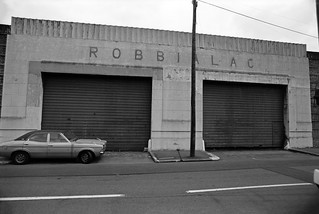
Jenson and Nicholson, Robbialac Works, Warton Road, Stratford, London E15.
Jensen and Nicholson were the makers of Robbialac paints and had premises here on Warton Road, offices on the Goswell Rd and a further works in Stratford on Carpenters Rd. The business was started in 1821 at the Barbican by William Kingham and John Jenson became a partner in 1840, taking over the business in 1848. He was joined in 1856 by Wilfred Nicholson.
Following a fire which destroyed the company’s factory, Nicholson decided to move to Stratford Marshes and a few years later Nicholson took over the company, which continued to trade under the name Jenson and Nicholson Ltd. As well as Robbialac enamel paints for cars and home decoration, the company also made Copal varnishes and distributed Cuprinol wood preservatives. In 1960 they merged with Berger Paints forming Berger, Jenson and Nicholson who after various takeovers became a part of Crown Paints and were then acquired by the Dutch company Akzo Nobel. (Information from Grace’s Guide https://www.gracesguide.co.uk/Jenson_and_Nicholson.)
The name Robbialac came from the 15th century Italian ceramicist Luca Della Robbia, famed for his brightly coloured enamels and the word lacquer. The major Portuguese paint manufacturer Tinta Robbialac, founded in 1928, also uses it as a brand name.
Bridgewater Rd, Stratford, Newham, 1983
The concrete bridge here is an early use of ferro-concrete I think had a plaque on it stating it had been built using the Hennebique system and certainly deserves preservation. I photographed it on various occasions and it survived the Olympics and was still present when I last visited the area, but I’m unsure if it will be retained in the future.
Waterworks River, Bridgewater Rd, Stratford, 1983
The view looking south from the Bridgewater Road bridge along the Waterworks River to the Warton House on Stratford High St, and blocks of flats on the opposite side of the street off Abbey Lane, Albert Bigg Point and Aubrey Moore Point. The footpath on the bank at right was extremely overgrown and the gates to it were locked. At right is one of the many pylons that were taken down for the Olympics.
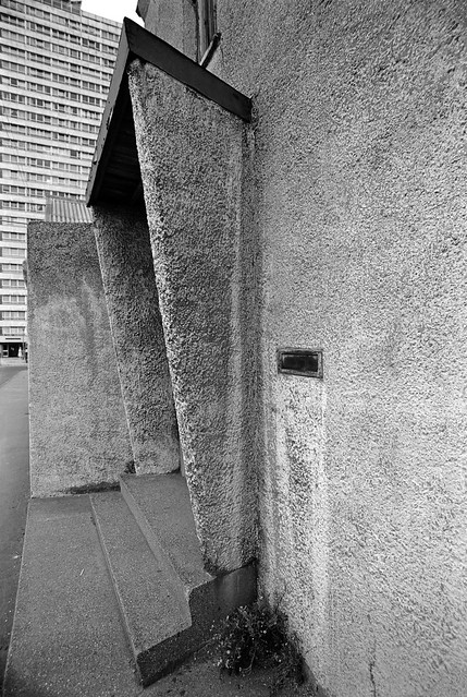
Carpenters Estate, Stratford, Newham, 1983
I am not sure of the exact location of this doorway with its interesting use of concrete. There were (and are) 3 point blocks on the Carpenters Estate and I think the one in the background here may be Dennison Point and this building may have been on the site now occupied by the Building Crafts College in Kennard Road which moved to a new building here in 2001.
Waterworks River, Railway Bridge, Stratford, Newham, 1983
I think this is from the footpath beside the Waterworks River looking north towards the bridge carrying the Eastern Region main line from Liverpool St across to Stratford. Possibly I had climbed down from Bridgewater Road as I think this path was closed at the time. The factory at right was on Warton Rd.
Waterworks River, view towards Blaker Rd from the Greenway, Stratford, 1983
The Waterworks River turns to the left in the distance to go under Stratford High St, with a channel going on under Blaker Rd to City Mill lock. The concrete pillar is part of the bridge carrying the Northern Outfall Sewer across the river and I wondered if the profuse fig tree growing here might be benefiting from some warmth from the sewage or possibly even be nourished by some leakage.
Kerry’s, Stratford 1983.
Kerry’s were a company that made and distributed a wide range of products, both those they made themselves and others branded with their name. In 1961 according to Grace’s Guide they were “Wholesale distributors to the motor, radio, electrical and cycle trades, also machine tool makers, specialising in centre lathes, boring mills, power saws, drills and special purpose machines” and even produced a light weight moped, the Capitano. Manufacturing moved to Basildon in the 1960s and the business was bought up and sold at the end of the decade.
Although Kerry’s address was Warton Road, I think the factory was actually rather closer to the Northern Outfall Sewer and reached over the bridge on Bridgewater Road.
All photographs on this and my other sites, unless otherwise stated, are taken by and copyright of Peter Marshall, and are available for reproduction or can be bought as prints.
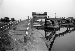
Footbridge, Carpenters Lock, Old River Lea, Stratford Marsh, Newham, 1983
I titled my self-published book put together in 2010 on the Lee Valley ‘Before the Olympics‘ because many of the pictures in it were taken in an area that was then being largely destroyed for a few weeks of sporting activities in 2012.
Footbridge, Carpenters Lock, Old River Lea, Stratford Marsh, Newham, 1992
It was an area that over the previous 25 or so years had held a particular fascination for me as a post-industrial wilderness close to the centre of London, one of the world’s greatest cities. Within a few yards of busy major roads I could find myself struggling to walk along overgrown paths – and sometimes having to climb over or around fences to do so. For months a pair of secatuers were needed in my camera bag to cut through the brambles that barred my progress (though when I wrote earlier about this I slightly exagerrated them as a ‘machete’.)
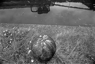
Old River Lee, Waterworks River, Stratford Marsh, Newham, 1983
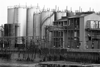
At times I spent hours wandering the area without meeting or seeing another living soul, or only across rivers, perhaps working in one of the many small businesses still at work, often in ramshackle buildings with smoke or steam emerging though ventilators or cracks. Or I would emerge from under a bridge or around a corner to see large industrial structures such as oil storage tanks.
Old River Lea, Stratford Marsh, Newham, 1983
It was of course an area that was bound to change, but not in the way it has. And the old was in some respects dystopian. Many of the remaining businesses were the kind that we like to hide away on the fringes, perhaps necessary but best kept out of sight. The River Lea was during the worst years of the development of industry the outer boundary of London, inside which there was a long history of restrictions to curb the activities of the most noxious and polluting industries; across that boundary almost anything went and factories were set up to enjoy that licence to pollute.
Old River Lee, Waterworks River, Stratford Marsh, Newham, 1983
Those years of largely unfettered industrial activity had left their toxic legacy in the soil, though some plants seemed to thrive on it. There were schemes to tidy up the area in the 1990s, with some streams and paths being cleared and the route beside the Waterworks River being decorated with art from junior schools in the area, but nature soon took it back , and a few years later I was again struggling through shoulder-high weeds.
Waterworks River, from Marshgate Lane, 1992
The Olympics were terra-forming, with tons of soil from the area being sterilised, tons being dumped elsewhere in landfill, and virgin soil brought in, in part from building work on the Channel Tunnel Rail Link. A new landscape emerged, retaining the watery outlines of the old, along with the Greenway and the major rail routes but with different land, and none of what was previously present on the rest of its surface, though with new white elephants fast being constructed.
Waterworks River from Marshgate Lane, Stratford Marsh, Newham, 1983
Waterworks River, 1992
Stratford Marsh, 1983
Marshgate Lane, 1983
All photographs on this and my other sites, unless otherwise stated, are taken by and copyright of Peter Marshall, and are available for reproduction or can be bought as prints.