Posts Tagged ‘timber yard’

Bow Creek from East India Dock Road

Tuesday, February 9th, 2021

Bow Creek, West Ham Power Station, East India Dock Rd, Tower Hamlets, Newham, 1989 89-4c55_2400
Bow Creek, West Ham Power Station, East India Dock Rd, Tower Hamlets, Newham, 1989

Bow Creek truly became magical as it passed under the East India Dock Road, and although it has now lost much of the interest on its banks, the incredible flattened S-shape as it curves before reaching the Thames remains impressive.

Bow Creek, West Ham Power Station, East India Dock Rd, Newham, 1989 89-4c56_2400
Bow Creek, West Ham Power Station, East India Dock Rd, Newham, 1989

The creek bends almost 90 degrees to flow roughly south under the road at Ironbridge Wharf (the iron bridge long replaces by more modern concrete structures) only to take a hairpin 180 degree bend to return almost back to the road before sweeping another 180 degrees down to go over the elevated Lower Lea Crossing. From there its convolutions continue with a 90 turn to the east and another to the south before entering the Thames as Leamouth, around 900 metres away as the gull flies, but 1900 by boat.

Bow Creek, East India Dock Rd, Poplar, Tower Hamlets, Newham, 198232f-24_2400
Bow Creek, East India Dock Rd, Poplar, Tower Hamlets, Newham, 1982

Its course defines two very different peninsulas; to the west on largely undeveloped and now a nature reserve, with the DLR crossing to it on a viaduct and running up it, and on the east an industrial site, then occupied by the edible oil company Pura Foods (earlier Acatos & Hutcheson) and now the site of the City Island development.

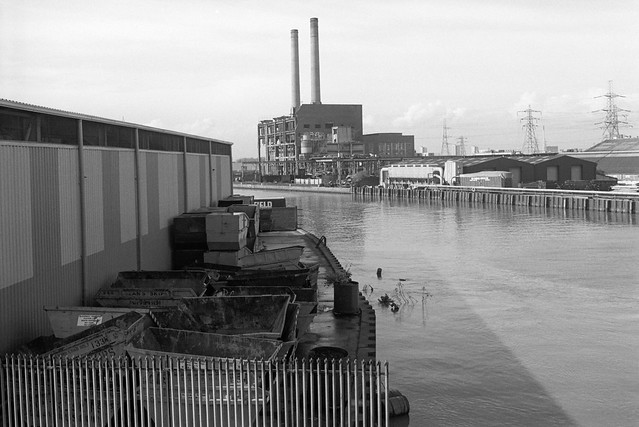
Timber yard,  Essex Wharf, Bow Creek, East India Dock Rd, Newham, Tower Hamlets, 1989 89-4c51_2400
Timber yard, Essex Wharf, Bow Creek, East India Dock Rd, Newham, Tower Hamlets, 1989

On the eastern bank of the river south of Canning Town station is another so-called peninsula, the Limmo Penisula, which became a major Crossrail works site and is now a housing development. The name was previously used for the whole area around this part of Bow Creek and the nature reserve, now the Bow Creek ecology park was first called the Limmo Peninsula ecological park. It is an area of confusing names, with the new development south of the Lower Lea Crossing taking its name, Goodluck Hope, from the area now called City Island. It was also easy to get a little confused by the area itself with the wandering of the river, and even when writing this post I had problems sorting out pictures just from the appropriate area.

Pipe Bridge, Bow Creek, Tower Hamlets, Newham, 1989 89-4c63_2400
Pipe Bridge, Bow Creek, Tower Hamlets, Newham, 1989

The pipe bridge possibly carried gas from the nearby Poplar Gas works to Canning Town; downstream was a disused railway bridge. A new ‘blue bridge’ was later erected between these two (it appears in my 1992 pictures) and the pipe bridge was taken down though its brick piers left in place – now only the eastern one remains.

Timber Yard, Bow Creek, Tower Hamlets, 1989 89-4c65_2400
Timber Yard, Bow Creek, Tower Hamlets, 1989

The pictures in this post were all taken on or close to the East India Dock Road where it crosses Bow Creek, beginning with a couple looking up river and with the rest looking towards the south. In later posts I’ll cover the area further down Bow Creek which played an important part in the industrial (and footballing) history of the nation, and return with the creek back almost to the road.

Bow Creek, Leamouth Rd, Leamouth, Tower Hamlets, Newham, 1982 32f-36_2400
Bow Creek, Leamouth Rd, Leamouth, Tower Hamlets, Newham, 1982

The pictures here are from visits to the area in 1982 and 1989, but I also took some in 1983, and returned again in 1992, mainly to make some panoramic views, which I’ll write about in a later post. You can see more of my pictures in my Flickr album – this area is on page 4 – and clicking on any of the above pictures will also take you to the larger version there.
Around High St Stratford

Tuesday, January 19th, 2021

St Thomas's Creek, Cook's Road, Stratford, Newham, 1983 35q-34_2400
St Thomas’s Creek, Cook’s Road, Stratford, Newham, 1983

There is and long seems to have been some confusion about the naming of this part of the canal system that links the main line of the Lea Navigation at Bow Bridge to the City Mill River and City Mill Lock. On some maps (including Google’s) it is simply referred to as ‘Bow Back Rivers’ but I find it less confusing to give it the more local name, St Thomas’s Creek, sometimes written as St Thomas Creek. The creek got its name from St. Thomas’s Mill, sometimes called ‘Pudding Mill’, I think because of its shape, which also gave its name to the small stream the Pudding Mill River and was actually on that stream on Pudding Mill Lane. For those interested there is a good map of the area before the flood relief works of 1931-5 on British History Online.

Yardley's Box Factory, Stratford High St, Stratford, Newham, 198336m-63-positive_2400
Warton House, former Yardley’s Box Factory, High St, Stratford, 1983

The earliest connection of the Yardley name to soap-making was in the first half of the 17th century, when a Yardley was given the concession to produce soap for the whole of London, but the company dated its founding as ‘Clever Brothers’ to 1770. This company making soaps and perfumes was taken over by William Yardley in 1823 and passed on to his son Charles when he died the following year. The company moved from Bloomsbury to a large factory on Carpenters Road Stratford in 1904 and bought land on Stratford High St in 1918. In 1913 they had trade-marked a picture by Francis Wheatley from his 1793 series, the ‘Cries of London’ to use in their advertising, replacing the primroses in his picture by lavender, and when they built a new art deco box factory in 1938 this was installed at a large scale on the building. Yardleys moved to Basildon in 1966, needing large premises, but in 1967 were taken over by British American Tobacco who sold the business to Beecham in 1985, who again sold it on after they merged to be SmithKlein Beecham. The company went into receivership in 1998. Parts of the box factory – including this section on the High St next to the Northern Outfall Sewer and the Waterworks River are still there, all that is left of Yardley’s in Stratford.

Stratford High St area, Stratford, Newham, 1983 36m-14_2400
Stratford High St area, 1982

I cannot remember exactly where I took this or the next picture, though from other exposures on the same films both are clearly somewhere not far from Stratford High St. I think the canal seen at right here is probably St Thomas’s Creek.

Timber yard, Stratford, Newham, 1982 32v-22_2400
Timber yard, Stratford High St area, 1982

Timber was the main product carried on the Lea Navigation in the later years of its use, and I think this timber yard was probably close to the main stream of the navigation. My attempts to find it again in later years were unsuccesful.

Cafe, Stratford market, Stratford, Newham, 1983 36p-35_2400
Cafe, Stratford market, Stratford, Newham, 1983

The notices on the door offer not just ‘Jellied Eels’ but ‘Best Jellied Eels’, along with ‘Loch Fine Kippers’. My contact sheet puts its location as Stratford Market in Burford Road, just off High St to the south.

Barge, Lea Navigation, Bow Bridge, Bow Flyover, Tower Hamlets, Newham, 1981 29t-26p_2400
Barges, Bow Bridge, October 1981

These last two pictures were some of the first I took in the area after I heard on a radio interview that commercial traffic on the Lea Navigation was to come to an end in a few weeks time.

I think it was the same day that I picked up my camera bag and got on the train to come to look for and photograph any remaining activity. It was a slow journey to Bromley-by-Bow from where I spent an hour or so walking along beside the navigation between Bow Locks and Bow Bridge, where I found three barges loaded with cut timber, photographing all three from the bridge and going down onto the wharf for another picture.

Barge, Lea Navigation, Bow Bridge, Tower Hamlets, Newham, 1981 29t-25_2400
Barges, Bow Bridge, October 1981

I find it hard now to understand why I took so few pictures – only around 30 exposures on the entire visit, and just these two where I found evidence of any remaining commercial traffic.

More pictures from the area on page 3 of my Flickr album River Lea – Lea Navigation 1981-1992.


All photographs on this and my other sites, unless otherwise stated, are taken by and copyright of Peter Marshall, and are available for reproduction or can be bought as prints.