Posts Tagged ‘Bow Creek’

To the Thames – 1983

Wednesday, February 17th, 2021

Canning Town, Newham, 1983 35t-36 (2)_2400

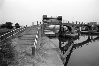
The whole area has changed so much since 1983 that I find it very confusing to locate the exact locations of many of the pictures that I took, and I’ve occasionally got some of the captions wrong. Often the only way I can be sure is by carefully studying other pictures that I took where I am sure of the location.

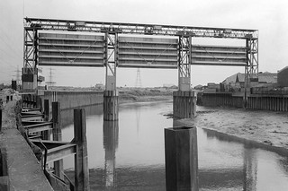
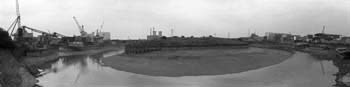
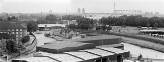
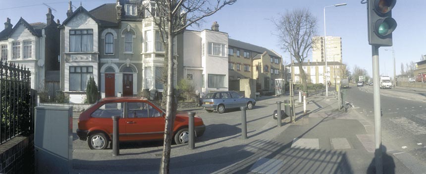
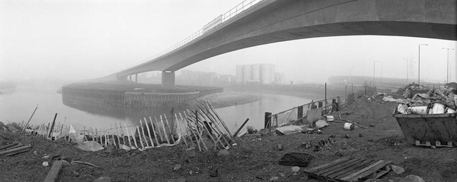
The building at the centre of the above image can be seen in one of the pictures posted yesterday, and is clearly on Victoria Dock Road, this section of the road completely obliterated in the construction of the Docklands Light Railway and the Canning Town transport interchange. Victoria Dock Road now begins on the other side of Silvertown Way. The picture above was taken from somewhere near the flood barrier.

Bow Creek, East India Dock Rd, Canning Town, Newham, 1983 35t-24_2400

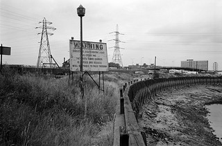
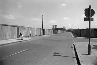
The warning light for the flood barrier was some way to the north, where the river bends around close to the East India Dock Road. At the left of the notice is a pub the East India Dock Road, long demolished, but both pylons are still there, along with the Newham Way flyover.

Bow Creek, Orchard Place, Tower Hamlets,  Newham,  1983 36a-26_2400

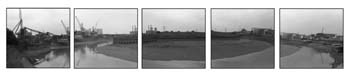
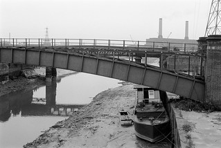
I think this picture was taken roughly where the Lower Lea Crossing now goes across Bow Creek and the river bends around to the east.

Leamouth Wharf, Orchard Place, Blackwall Point Power Station, Bow Creek, Tower Hamlets, Newham, 1983 36a-15_2400

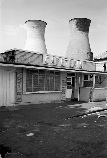
It is difficult to pinpoint the locations of these views taken on the same day as I walked down beside Bow Creek towards the Thames. The pylon visible here was on the north-east corner of the East India Dock Basin next to Orchard Place and has since been removed. The chimney is a small mystery as I think this is Brunswick Wharf power station which had two chimneys – but I may have carefully lined them up so one is hidden behind the other. In 1983 the station was still in use and only decommissioned in 1984.

Bow Creek, River Thames, Blackwall Point, Power Station, Trinity Buoy Wharf, Newham, Tower Hamlets, 1983 35t-34 (2)_2400

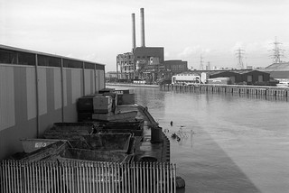
Things are much clearer as the River Thames comes into view, and the creek swings around yet again towards the south. The power station across the river is the Blackwall Point Power Station on a site close to where the Millennium Dome was later built.

Bow Creek, Thames Wharf, Newham, 1983 35t-65_2400

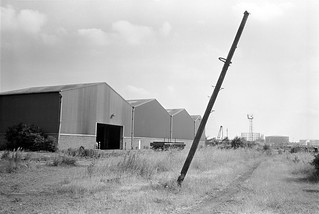
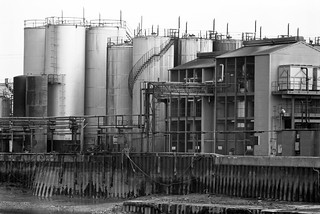
There was then still a railway line leading down to Thames Wharf, and this was still an industrial area. Things are rather busier not with these sheds still in use and the whole area here is now covered by piles of steel stocks as you can see from satellite images on Google.

River Thames, Bow Creek, Lighthouse, Trinity Buoy Wharf, Tower Hamlets, 1983 35t-31_2400

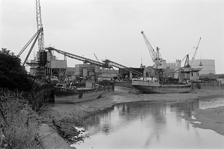
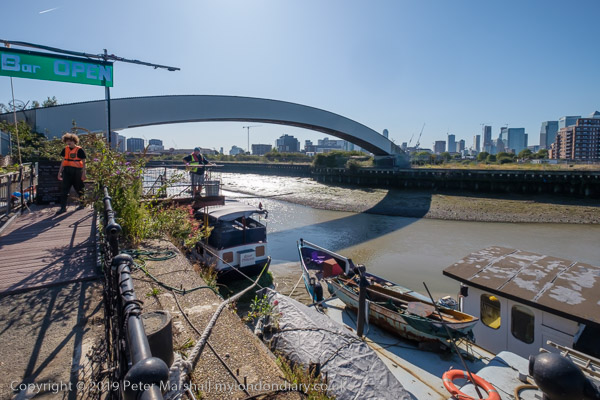
Across Bow Creek I got a good view of London’s only lighthouse, at Trinity Buoy Wharf. Some years later I was to visit this site on various occasions for several art projects, including a show in which a few of my pictures of Bow Creek were part of the display. And with the late lamented London Arts Cafe I came to a picnic on the riverside and sat in the lighthouse to listen for a few minutes to Jem Finer’s Longplayer which began its thousand year performance here at midnight on the 31st of December 1999. But until 1988 it was still owned by Trinity House and busy maintaining buoys.

Heavy Rain, LimehouseBasin, entrance, River Thames, Limehouse, Tower Hamlets, 1983

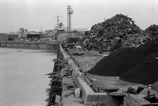
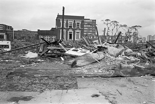
Thames Wharf on the River Thames was a busy industrial site which back then seemed mainly to be dealing in scrap metal, and I had to walk around a few heaps to make my way along the river. Although I rather felt I was trespassing, no one approached me. Security was far less strict back then.

Thames Wharf, Victoria Dock Entrance, River Thames, Silvertown, Newham 36a-51_2400

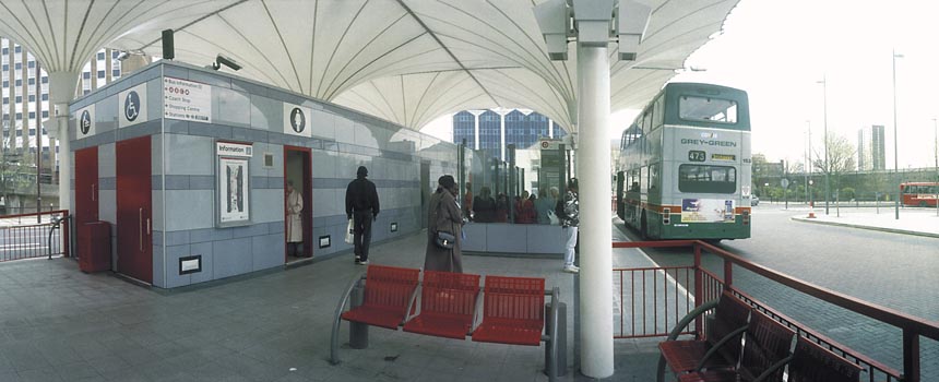
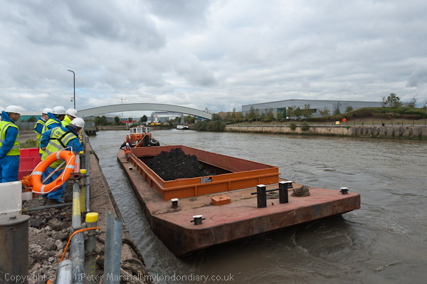
This was around the limit of my walk and having taken my pictures – you can see a few more on Flickr – I walked back up Dock Road to Silvertown Way. I doubt if you can follow much of my walk today, but you do get a good overhead view of the area from the dangleway, London’s cable car across the Thames from North Greenwich to Victoria Dock. But don’t wait too long, as the sponsorship deal with the Emirates Air Line ends in 2022 and the future of this hugely loss-making service must be in doubt.


All photographs on this and my other sites, unless otherwise stated, are taken by and copyright of Peter Marshall, and are available for reproduction or can be bought as prints.


Saw Mills & Flood Barrier

Tuesday, February 16th, 2021

M & J Reuben, London Sawmills, Wharfside Rd, Newham, 1983 35t-25_2400

Standing more or less on the bank of Bow Creek beside the saw mill in 1983 I could see the elevated East India Dock Rd from which quite a few of my pictures were taken, and beyond it the box-like West Ham Power Station with its two pencil-like chimneys and cooling towers. Sawing timber creates a great deal of dust and a large extractor removes this, probably more for its commercial value than an anti-pollution measure.

Bow Creek, Flood Barrier, Saw Mill, Wharfside Rd, Newham, 1983 36v-25_2400

Looking down from East India Dock Rd onto the circular car park where Wharfedale Rd emerged from the tunnel under the road. There were few if any traces of the old railway line that used to run between the fence and the river here – where the DLR now runs. The picture gives a good impression of the densely packed industry on the peninsula beyond the creek. Taken with an extreme wide-angle lens – the 21mm on the Olympus OM1 you can see some stretching of objects closer to the edges of the frame which is a consequence of rectilinear perspective.

Bow Creek,  Flood Barrier, Wharfside Rd, Newham, 1983 35t-11_2400

Working from more or less the same position (but on a different day) with a less wide lens (probably a 35mm) gives a considerably less wide view, making distant objects seem larger, and also avoids any noticeable distortion. You can see the flood barrier on Bow Creek much more clearly.

Canning Town, Flood Barrier, Bow Creek, East India Dock Rd, Newham, 1982 36v-26_2400

Moving a little further along East India Dock Road gave a better view of the river now running south through the flood barrier. At left are the tower blocks of Canning Town. The row of buildings at right are on the far side of Victoria Road, and the railway line from Stratford to North Woolwich is in front of them, hidden by a bank of earth. Stairs led down from the road to this waste land and there were no fences to stop me walking along the river bank.

Flood Barrier, Bow Creek, Newham, Tower Hamlets, 1983 36a-32_2400

From the bank I got a good view of the flood barrier, its three gates in raised position, getting shorter from left to right to match the slope of the creek, deeper on the outside of the curve. Building the Thames Barrier at Charlton which first came into operation at more or less at the time I made this picture made this barrier, previously essential to prevent flooding along Bow Creek, redundant. It was removed shortly after I made these pictures.

Flood Barrier, Bow Creek, Newham, Tower Hamlets, 1983 36a-36_2400

Back in 1983 there were no barriers to stop me walking beside Bow Creek all the way to the River Thames, but not long afterwards this whole bank was closed off to the public. There have long been plans to open part of it as a riverside walkway, with the northern part of it built but fenced off, and in 2004 following a public competition a winning design was selected for a bridge further downstream a little below the Lower Lea Crossing across the river as a part of this foot and cycle path to Trinity Buoy Wharf. But in 2005 the Thames Gateway Delivery Unit withdrew funding and the bridge was never built. The last time I visited the area a couple of years ago the riverside walkway was open but ended around a hundred yards south of Canning Town station.

Flood Barrier, Bow Creek, Newham, Tower Hamlets, 1983 36a-23_2400

There is now a bridge across close to Canning Town station leading to the development of City Island which has replaced the edible oil factory on the peninsula which opened in 2014, though a far less interesting design than the competition winner.

The empty area to the east of Bow Creek which can be seen in some of these pictures was from 1837 to 1912 the home of the Thames Ironworks and Shipbuilding Company Ltd. More recently it was for some years given over to a construction works yard for Cross Rail and is now home to the Limmo Peninsula, a largely residential development scheme by a partnership between TfL and Grainger plc.

You can visit my Flickr album with more pictures of the area by clicking on any of the pictures above which will take you to a larger version from where you can explore the album. Future posts will look at a series of panoramic pictures I made in 1992 and continuing my walk to the Thames.


All photographs on this and my other sites, unless otherwise stated, are taken by and copyright of Peter Marshall, and are available for reproduction or can be bought as prints.


Bow Creek: Priors to Pura Foods

Monday, February 15th, 2021

Bow Creek, Leamouth Rd, Leamouth, Tower Hamlets, Newham, 1982 36v-23_2400

Goiong down Leamouth Road roughly south and parallel to the river there were a few places where you could look back up to the East India Dock Road and the disused railway bridge that crossed the creek a little to the south of the road. The bridge had carried a line which came from where Canning Town Station now is along the route now followed by the DLR but continuing across the river to pepper warehouses for the East India Docks opposite the docks on the eastern side of Leamouth Road, still shown on my 1939 Philip’s A B C Pocket Atlas-Guide to London and its Outer Districts.

J J Prior, Ship Repairs, Orchard Wharf, Bow Creek, Leamouth Rd, Leamouth, Tower Hamlets, 1982 36v-36 (2)_2400

Where the river swung around the Limmo Peninsula – now the Bow Creek Ecology Park – the view was wide open with the river only separated from the road by an open fence. Close to the bend to the west was Orchard Wharf, where J J Prior were still carrying out ship repairs. The flats in the background are on the other side of the East India Dock Road.

Pura Foors, Bow Creek, Tower Hamlets, 1983 36v-21_2400

Looking up the creek on the eastern side of the peninisula was the west bank of the second peninsula, occupied by a large edible oil factory, Pura Foods, the smells from which were often rather noticeable. There were local campaigns to have this factory shut down, and eventually it did move out, relocating a few miles down-river. This peninsula is now redeveloped as City Island.

Pura Foods, Orchard Place, Leamouth, Tower Hamlets, 1982 32f-33_2400

Roads in this area were disrupted when the Lower Lea Crossing was built – it opened in 1991. When I first went to photograph the area, Leamouth Road (historically called Orchard St) continued to meet Orchard Place at a T-junction, with Orchard Place going north to the Pura Food site and south, then turning east to Trinity Buoy Wharf.

Pura Foods, Bow Creek, Tower Hamlets, 1989 89-4c52_2400

Although there were still high walls along the northern section of Leamouth Rd, there was a clear view of Bow Creek looking south from the East India Dock Road only around a hundred yards east of where the river, here flowing roughly north, went under the bridge in the opposite direction.

Bow Creek, Pura Foods, Essex Wharf, Wharfside Rd, East India Dock Rd, Newham, Tower Hamlets, 1989 89-4b12_2400

Wharfside Road comes in a short tunnel under the East India Dock Road on which I was standing to take this picture, leading to Essex Wharf and the saw mills for the timber yard. The Docklands Light Railway now runs along here on the route of the the former rail line to the pepper warehouses, just in front of the line of parked cars in this picture.

There is now a footbridge across the DLR leading to a riverside path, built at around the same time as the new railway, the gates to the bridge were kept locked for most of its first twenty years but now seem to be permanently opened, and it provides a good short cut to Canning Town Station, whose riverside entrance was also locked for years after it was built, as well as to a new footbridge to City Island which replaced the factory here. You can also now walk or cycle down here to the right to visit the Bow Creek Ecology Park. Although very different it is still an interesting area in which to walk.

Clicking on any of the above images will take you to larger versions in my Flickr album on the River Lea. A further post will start at Wharfside Road and look at my pictures moving along Bow Creek towards the Thames.


All photographs on this and my other sites, unless otherwise stated, are taken by and copyright of Peter Marshall, and are available for reproduction or can be bought as prints.


Leamouth Panorama 1982

Saturday, February 13th, 2021
East India Dock Gates, Leamouth Rd, Leamouth, Tower Hamlets, 19882 32e-14_2400

It was back in July 1982 I took my first walk down Leamouth Road, where there were still high walls for the closed East India Docks and some wharves on Bow Creek were still in use, their walls and sheds hiding the river from view. But at the southern end, where the river swung around a 180 degree bend, the view opened up, with only a fence and a couple of feet of weed-covered earth between the pavement and the river wall. It was getting late and I had to rush away, but I had seen a view that I could not do justice too with even my widest lens, a 21mm f3.5 Zuiko.

Bow Creek, Leamouth Rd, Leamouth, Tower Hamlets, Newham, 1982 32f-63_2400

The fence was old and rusty, and one short section had broken, and on my return in August I made my way through the gap with my hefty Manfrotto tripod. There wasn’t enough space to set it up properly with the legs fully extended and opened, but after a bit of a struggle I managed to get it level. I checked it with the separate spirit level I carried in my camera bag, then put my Olympus OM1 in place and checked with the level again.

J J Prior, Ship Repairs, Orchard Wharf, Bow Creek, Leamouth Rd, Leamouth, Tower Hamlets, 1982 32f-53_2400

It was a slow business, and I was just a little worried that someone might come along and question what I was doing, though rather more worried that I might fall over the low wall onto the muddy shingle perhaps 6ft below.

J J Prior, Ship Repairs, Orchard Wharf, Bow Creek, Leamouth Rd, Leamouth, Tower Hamlets, 1982 32f-54p_2400

I think the lens I used was probably the 35mm f2.8 shift, though at its central non-shifted position, and I tried to position its nodal point roughly above the axis of rotation, though it was not too critical here as only the first and final exposures would include any near detail.

32f-56p_2400

I then began a series of six exposures, swinging the camera on the tripod roughly 30 degrees between each exposure (the tripod has a scale in degrees) using the handle on the pan and tilt head. All went well until the last of six exposures, though it was a little tricky working in a rather confined space, and I needed to move away from where I had been crouching to the right of the tripod so as not to be in the picture.

Bow Creek, Leamouth Rd, Leamouth, Tower Hamlets, Newham, 1982 32f-41p_2400

It wasn’t a tragedy as I squeezed between the tripod and the fence, and I managed not to knock the whole set-up into the creek, but I did knock it a little out of place, and while the first five exposures have the horizon almost exactly level, the sixth was perhaps ten degrees askew.

Of course I took a replacement, and it was only after I’d printed it that I found it wasn’t quite an exact fit, and when I carefully cut and pasted the six prints to make a single panoramic image the difference showed, at least to me. So instead I put the images, cropped slightly to reduce the overlap, into a row of images with a margin between each of them. More recently of course I’ve been able to scan the images and combine the digital files, and it more or less works, but ends up with a very long thin panorama that doesn’t work well on screen.

A few years later I returned with a panoramic camera and made a very different picture just a few yards away, but the original scene had changed dramatically.

Clicking on any of the larger pictures in this post will take you to a larger version in my Flickr album, from where you can explore other pictures of Bow Creek.


All photographs on this and my other sites, unless otherwise stated, are taken by and copyright of Peter Marshall, and are available for reproduction or can be bought as prints.


Bow Creek from East India Dock Road

Tuesday, February 9th, 2021

Bow Creek, West Ham Power Station, East India Dock Rd, Tower Hamlets, Newham, 1989 89-4c55_2400
Bow Creek, West Ham Power Station, East India Dock Rd, Tower Hamlets, Newham, 1989

Bow Creek truly became magical as it passed under the East India Dock Road, and although it has now lost much of the interest on its banks, the incredible flattened S-shape as it curves before reaching the Thames remains impressive.

Bow Creek, West Ham Power Station, East India Dock Rd, Newham, 1989 89-4c56_2400
Bow Creek, West Ham Power Station, East India Dock Rd, Newham, 1989

The creek bends almost 90 degrees to flow roughly south under the road at Ironbridge Wharf (the iron bridge long replaces by more modern concrete structures) only to take a hairpin 180 degree bend to return almost back to the road before sweeping another 180 degrees down to go over the elevated Lower Lea Crossing. From there its convolutions continue with a 90 turn to the east and another to the south before entering the Thames as Leamouth, around 900 metres away as the gull flies, but 1900 by boat.

Bow Creek, East India Dock Rd, Poplar, Tower Hamlets, Newham, 198232f-24_2400
Bow Creek, East India Dock Rd, Poplar, Tower Hamlets, Newham, 1982

Its course defines two very different peninsulas; to the west on largely undeveloped and now a nature reserve, with the DLR crossing to it on a viaduct and running up it, and on the east an industrial site, then occupied by the edible oil company Pura Foods (earlier Acatos & Hutcheson) and now the site of the City Island development.

Timber yard,  Essex Wharf, Bow Creek, East India Dock Rd, Newham, Tower Hamlets, 1989 89-4c51_2400
Timber yard, Essex Wharf, Bow Creek, East India Dock Rd, Newham, Tower Hamlets, 1989

On the eastern bank of the river south of Canning Town station is another so-called peninsula, the Limmo Penisula, which became a major Crossrail works site and is now a housing development. The name was previously used for the whole area around this part of Bow Creek and the nature reserve, now the Bow Creek ecology park was first called the Limmo Peninsula ecological park. It is an area of confusing names, with the new development south of the Lower Lea Crossing taking its name, Goodluck Hope, from the area now called City Island. It was also easy to get a little confused by the area itself with the wandering of the river, and even when writing this post I had problems sorting out pictures just from the appropriate area.

Pipe Bridge, Bow Creek, Tower Hamlets, Newham, 1989 89-4c63_2400
Pipe Bridge, Bow Creek, Tower Hamlets, Newham, 1989

The pipe bridge possibly carried gas from the nearby Poplar Gas works to Canning Town; downstream was a disused railway bridge. A new ‘blue bridge’ was later erected between these two (it appears in my 1992 pictures) and the pipe bridge was taken down though its brick piers left in place – now only the eastern one remains.

Timber Yard, Bow Creek, Tower Hamlets, 1989 89-4c65_2400
Timber Yard, Bow Creek, Tower Hamlets, 1989

The pictures in this post were all taken on or close to the East India Dock Road where it crosses Bow Creek, beginning with a couple looking up river and with the rest looking towards the south. In later posts I’ll cover the area further down Bow Creek which played an important part in the industrial (and footballing) history of the nation, and return with the creek back almost to the road.

Bow Creek, Leamouth Rd, Leamouth, Tower Hamlets, Newham, 1982 32f-36_2400
Bow Creek, Leamouth Rd, Leamouth, Tower Hamlets, Newham, 1982

The pictures here are from visits to the area in 1982 and 1989, but I also took some in 1983, and returned again in 1992, mainly to make some panoramic views, which I’ll write about in a later post. You can see more of my pictures in my Flickr album – this area is on page 4 – and clicking on any of the above pictures will also take you to the larger version there.

South of Bow Locks – the 1980s

Saturday, February 6th, 2021

Bow Creek, Bow Locks, Hackney, Tower Hamlets, 1983 36v-52_2400

Back in the 1980s it wasn’t possible to walk beside Bow Creek from Bow Locks south to the East India Dock road, as the banks were occupied by various industrial and commercial sites, including two gas works and West Ham power station. And although there have been plans by the councils for many years, even today you can only walk down on the Newham bank as far as Cody Dock, on a path opened to the public some years ago with the ridiculous name of the Fatwalk, but since renamed. There is a tantalising walkway visible continuing past the dock along the former power station bank, but this is still closed to the public.

Clinic, Bromley-by-Bow, Tower Hamlets, 1983 35v-35_2400

While this was a limitation, it was also an opportunity to explore the two areas where roads ran close (or not too close) to Bow Creek to both the east in West Ham and west in Bromley and Poplar, and I was rewarded by some images I found interesting, though parts of my walks were along fume laden streets with heavy traffic.

Blackwall Tunnel Northern Approach, Tweed House, view, Bromley-by-Bow, Tower Hamlets, 1983 35v-3pan_2400

Tweed House, a tall block of council flats on the Blackwall Tunnel Approach Road next to the Limehouse Cut enabled me to take some pictures which I more recently stitched together to create two panoramas of the area – the individual pictures are also in the Flickr album. Click to see the larger versions on Flickr.

Blackwall Tunnel Northern Approach, Tweed House, view, Bromley-by-Bow, Tower Hamlets, 1983 35v-4-pan_2400

From various places both on to the east and west of Bow Creek I found rather satisfyingly bleak views of the distant power station, including one with a young mother with a small baby in a pram.

Lochnagar St, Bromley-by-Bow, Tower Hamlets, 1983 36v-42_2400

Others were emptier still, like this

Lorry Park, Gillender St, Bromley-by-Bow, Tower Hamlets, 1982 32e-42_2400

or more minimal and just occasionally rather threatening; some streets around here featured in crime films and TV dramas of the era, gangster London.

Lochnager St, Poplar, Tower Hamlets, 1982 32e-34_2400

But there was also a little chance for fun, with a cafeteria with two giant cooling towers to take away the cooking fumes and the unlikely name of Oasis.

Oasis, Cafeteria, Cafe, Bidder St, West Ham, Newham, 1983 36v-12_2400

Poplar Gas Works was on a rather smaller scale to Bromley-by-Bow, but its gas holders still dominated the working class housing around it. Two young girls playing on the grass came to see what I was doing and insisted on being photographed, though I perhaps should have stepped back a foot or two to avoid cropping their feet to get the gasholder in the frame.

Girls, Gasholder, Poplar Gas Works, Rutland Terrace, Oban St, Poplar, Tower Hamlets, 1983 35v-55_2400

At East India Dock Road I was able to return to Bow Creek – and things got even more interesting (and although very different they still are) as I hope to show you in the next installment of my work from the Flick album River Lea – Lea Navigation – 1981-92 – the pictures above are all on Page 4.

Clicking on any of the images above should take you to a larger version on Flickr, and you can also go on to explore the album from there.


All photographs on this and my other sites, unless otherwise stated, are taken by and copyright of Peter Marshall, and are available for reproduction or can be bought as prints.


Meridian 2

Wednesday, August 26th, 2020

Continuing with pictures from my walk along the Greenwich Meridian in Greater London in 1984-6.

Stratford Bus Station – Peter Marshall, 1995

My walks took me as close to the line of the Meridian I had pencilled on my 1983 1:25000 OS map as possible, though that line may not have been quite exact. I think it goes through the area at the extreme left of the picture above, here just a few yards east of the roadway. My series of walks kept as close as possible to the pencil line, but it often runs through private property, buildings, across rivers etc and many detours, some quite lengthy were required.

Barge carries contaminated earth from Poplar gasworks site, Peter Marshall, 2011

One of those fairly lengthy detours was north from Poplar, where the line ran through the gas works site and across Bow Creek. It wasn’t until 2011 that I was able to go onto the former gas works site, having been engaged to photograph the use of a barge to carry away the heavily contaminated soil from the site. The line crosses the river here, going through the left end of the large shed close to the opposite bank, near to Cody Dock. This is also part of a private business estate, though you can now walk along the roadways in it. There are several such areas I have been able to photograph in later years, but I won’t add any other later pictures to these posts.

Stratford Station – Peter Marshall, 1995

The line continues through the east end of Stratford Station.

Thinking of the line of the Meridian, I had decided it was appropriate to use a panoramic format, and these pictures were all taken with a swing lens panoramic camera. I think at the time I owned two such cameras, an expensive Japanese model and a cheap Russian one. The Russian was a little more temperamental and it was sometimes difficult to wind on the film, but had a much better viewfinder and I think was probably used for most of these. Both give negatives which are roughly the width of medium format film – 55-58mm – but only 24mm high, the limit of 35mm film, giving a roughly 2.3:1 aspect ratio. There is no discernible difference in image quality.

Langthorne Rd, Leyton – Peter Marshall, 1995

Both used 35mm film and curve it in the horizontal plane around a little over a third of the outside of a circle, with the lens pivoting roughly 130 degrees around the centre of that circle during the exposure. This keeps the distance between the centre of the lens and film constant, avoiding the distortion produced by using flat film, where the edges of the film are further from the lens node. This gives a very noticeable distortion with ultra-wide lenses, limiting them to an angle of view (horizontal) of roughly 100 degrees.

St Patrick’s Cemetery, Leyton

Swing lens cameras are limited in angle of view only by the mechanical limitations and can generally cover 130-140 degrees. But the curvature of the film does produce its own unique view. Assuming you keep the camera upright, straight vertical lines remain straight as the film is not curved vertically, but non-vertical lines show curvature, increasingly so as you move away from the centre of the film. You can see this clearly in the shop window in Langthorne Rd.

Whipps Cross – Peter Marshall, 1985

To be continued…

Bromley-by-Bow to Star Lane

Thursday, February 27th, 2020
Bow Creek from Twelvetrees Crescent bridge

When I was busy photographing London as urban landscape in the 1980s and 90s little of the area to the east of Bow Creek was accessible, occupied by a gas works, a power station and a large private industrial estate and it was more or less a no-go area for photographers.

Iron Mountain

Around ten years ago, the riverside walk on the east bank south from Twelvetrees Crescent was reopend as ‘The Fatwalk’ but there were several problems. One was the name, and I proposed back then it be renamed as ‘The Bow Creek Trail‘. My suggestion wasn’t taken up (perhaps those guys just don’t read ‘My London Diary’ or ‘Re:PHOTO’) but around 2016 it was renamed and is now ‘The Leaway’, which is just slightly silly and geographically imprecise. And when we walk it we hope our course will not shift a little sideways and deposit us in the mud or deep water of the creek.

A sculpture on ‘The Line’

Back in 2010 when I first used it the main problem was that it was a dead end. You could (and I did) go south for around 5/8ths of a mile but you then simply had to turn around and come back. I was on my Brompton, so I didn’t much mind, but had I been walking I would have been annoyed.

Cody Dock

Things have improved a little at both ends of this short stretch. Cody Dock has opened at the south end, allowing the exit I took today with a fairly short walk to Star Lane DLR station, which opened in 2011. The adventurous could swing themselves around the fence at the south of Cody Dock onto what looks like a perfectly good path beyond, and possibly make their way out through the Electra Business Park as a longer route to Star Lane, but there is still no access to the creek bank between the business park and the East India Dock Road.

From Star Lane DLR

Going north from Twelvetrees Crescent is now easier, with new steps from the bridge there leading down to the path beside the Lea Navigation, which previously needed an unpleasant detour. You can keep on walking beside the Lea from here to Hertford.

More pictures and text: Bromley-by-Bow to Star Lane


All photographs on this and my other sites, unless otherwise stated, are taken by and copyright of Peter Marshall, and are available for reproduction or can be bought as prints.

There are no adverts on this site and it receives no sponsorship, and I like to keep it that way. But it does take a considerable amount of my time and thought, and if you enjoy reading it, please share on social media.
And small donations via Paypal – perhaps the cost of a beer – would be appreciated.


Secret Rivers

Tuesday, May 28th, 2019

Just opened at the Museum of London Docklands is the exhibition Secret Rivers, which is worth going to see if you are around – and is free. Not all of the rivers featured are secret – they include the Thames and the Lea – but they are all of interest. As well as videos and maps and pictures including a few photographs there are also objects found in the rivers on display.

I’ll leave more general comments about the show to the reviews listed at the bottom of this post, but say a little more about my own minor contribution, the picture above of the DLR being built across the not very secret Bow Creek which I made in morning fog back in 1992. It was one of around a dozen images of the DLR extension shown as part of a group show on Transport at the Museum of London later that year.

I’d left home early on a Sunday morning in mid-January as a fine morning with clear sky was dawning, catching the first early morning train to Richmond then the North London Link to Canning Town. As we approached the destination I was disappointed to find everywhere was shrouded in mist; had I known I would have stayed in bed at home!

I’d recently bought what was then the most expensive camera I’d ever owned, a new Japanese Widelux 35mm model, a rotating swing lens camera, which had cost me around £2000 (equivalent to around £7000 today allowing for inflation) and had decided this was an ideal project to make use of its unique characteristics.

I was pretty fed up with the mist, as I wanted nice clear pictures, and it was also much colder than I’d anticipated in the mist, but as I’d spent a couple of hours travelling to the location I decided to take some pictures, and stuck at it for an hour or two, making around 40 exposures – roughly two films. The camera gave around 21 exposures on a normal 36x 35mm casette with negatives the same width as those made with a 6×6 camera but only 24mm tall.

It was a slow job, as the camera had to be carefully levelled on a tripod for each picture, otherwise the horizon would appear curved. The viewfinder was imprecise, and I soon learnt it was better to rely on the two arrows on the top plate which indicated the field of view to visualise the result.

The camera used no batteries, but was clockwork and entirely manual. Winding on the film also wound the shutter and rotated the lens, held in a vertical cylinder in front of the curved film behind, to its starting point. On pressing the shutter release, a slit behind the lens opened to epose the film as the lens rotated around a roughly 130 degree arc. I think the shutter speed was probably 1/125 s, based on the exposure of any point on the film, but it took perhaps 1/30th for the slit to travel across the film as the lens rotated.

I calculated the exposure using a separate hand-held meter, a Weston Master V, which could make relected light readings as in-camera meters do or, with the aid of a curiously shaped lump of translucent plastic, it could measure the light falling on your subject, almost certainly what I used for these pictures in the fog. The Weston meters used a selenium photo cell around two inches in diameter, which generated enough electricity to power the meter, and again needed no battery.

I’d walked from Canning Town down the Silvertown Way and over the Lower Lea Crossing to where the DLR crossed the creek. The mist I think was rather thicker than it looks in the picture, and I could hardly see Pura Foods. I took a few more pictures then my way back via the East India Dock Road to Canning Town cold and disappointed. It seemed to me to have been a wasted day – and I came back a week later to retake the images in clear daylight.

Once I’d developed and printed the films a couple of weeks later, I realised that although for most of what I’d taken the mist really spoiled the pictures, this image, with the viaduct disappearing into the distance was rather special. It remains one of my most widely published and exhibited works, but is the only one from that foggy day day that appears on my River Lea website.

More about the Secret Rivers show at:
Londonist
London Live (video)
The Guardian
Evening Standard
MuseumCrush

There are no adverts on this site and it receives no sponsorship, and I like to keep it that way. But it does take a considerable amount of my time and thought, and if you enjoy reading it, please share on social media.
And small donations via Paypal – perhaps the cost of a beer – would be appreciated.

All photographs on this and my other sites, unless otherwise stated, are taken by and copyright of Peter Marshall, and are available for reproduction or can be bought as prints.

To order prints or reproduce images