The road layout in this area has changed completely since 1994, but you can see at right the DLR Beckton branch going over the concrete lead-up to the Connaught Bridge. I think GATE 30 at extreme left is to the Excel site and the Connaught Tavern is hidden by the trees in the centre of the picture – and so this road was the old Connaught Road which led to the old swing bridge. I think where I was standing is now the middle of a hotel car park.
Bridges, Bow Creek, East India Dock Rd, East India, Tower Hamlets, Newham, 1994, 94-719-61
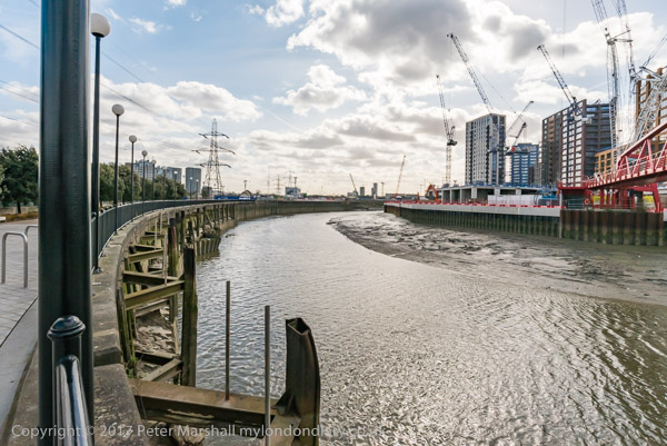
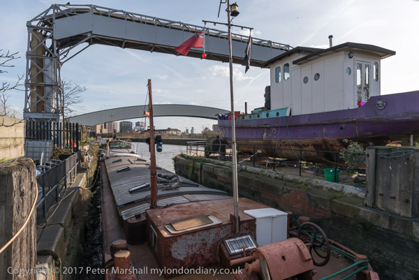
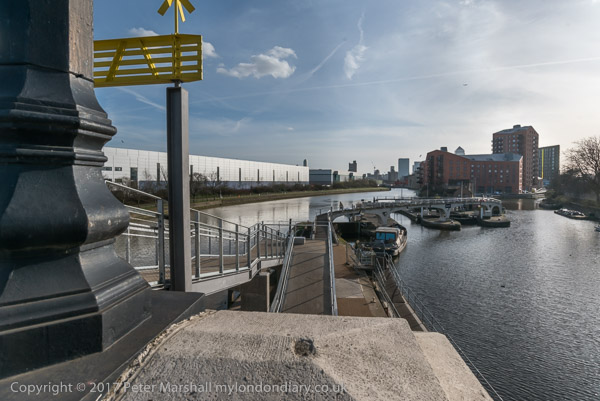
I moved around a mile and a half west and four stops along the DLR line to Canning Town and one of my favourite areas around Bow Creek, which here does two more or less 180 degree turns before flowing into the Thames. These two ‘bridges’ are a few yards south of East India Dock Road and I think both were built as pipe bridges to carry gas across the river.
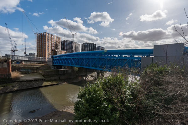
Only the brick end supports of first remain on each bank. The metal bridge in the centre of the image is also a footbridge, now painted blue and leading across the river to the ecology park. Just beyond it, almost completely hidden is a third bridge, a long disused rail bridge. At left are the sheds of a timber yard.
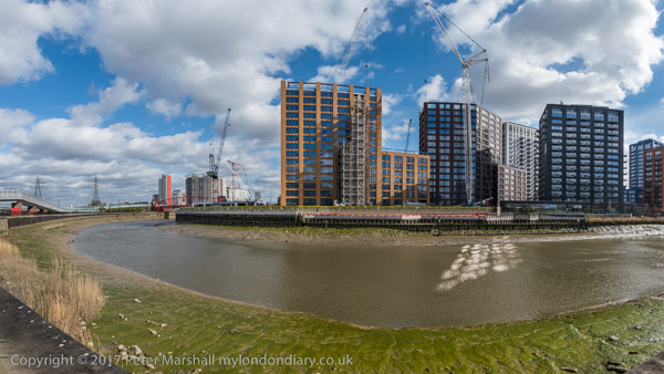
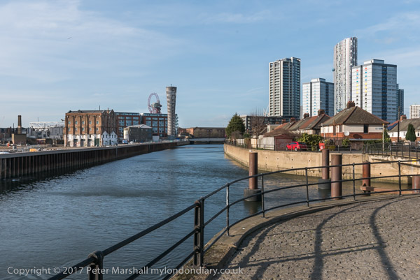
Further East on the East India Dock Road I made this panorama with a sawmill in Wharfdale Road. Beyond that road is a train on the DLR line, and over the top of this you can see the Pura Foods factory on the site where London City Island now is.
A few yards further east on East India Dock Road gave this view of Bow Creek, curving 180 degrees around Pura Foods. Locals were pleased to see this London City Island factory go as you could smell it across much of Canning Town.
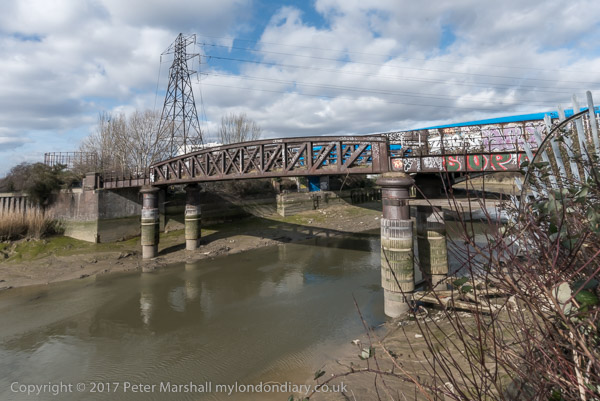
A few yards away I used a crane to frame the image of Pura Foods on its not quite island site. At right of the picture is a bridge across the DLR leading to a riverside walk to Canning Town Station. Although I managed to walk across Reuben’s Bridge several times, it has been mainly locked for the last thirty years, despite being a useful short cut to the riverside station entrance.
Apparently it was closed because people were throwing stones from it onto the DLR, and more recently in 2019 a survey determined that it is non-compliant with current Health & Safety Legislation, Building Regulations, British Standards and associated supplementary guidance.
The initial plans were for the riverside walkway to lead all the way to Trinity Buoy Wharf at the mouth of Bow Creek – and a competition was held and awarded for a new footbridge to enable this – but then the plans were dropped. Until a new bridge was built for London City Island the riverside entrance to Canning Town station only led to two dead ends.
Canning Town, Cody Dock and Stratford: On Thursday 2nd March 2017 I made a rather convoluted walk along Bow Creek and the Lea Navigation, arranged around a meeting I had at Cody Dock. You couldn’t then – and can’t quite yet walk beside the river the whole way, but to get to the meeting I had to abandon a small part of the first stretch and catch the DLR, walking on from the meeting to Stratford High Street where I caught the DLR again to go back and complete the short part I’d had to miss out earlier.
In this section of My London Diary I included pictures taken both at the start and at the end of my walk, which began at Canning Town Station.
The riverside walkway at Canning Town is open after many years and can take you to the bridge to London City Island.
People were living in some of the blocks on the “Island” but there was still a lot of work continuing in this area which Bow Creek loops around on three sides. Another bridge was built across the DLR tracks to allow people from South Bromley in Tower Hamlets a pedestrian route to the riverside path and Canning Town station. Open for a short time it closed well before the station entrance became open, and a gate on it was firmly locked when I tried to cross it.
This meant I had to make a lengthy detour walking around the Ecology park to get to the Blue Bridge which took me to the East India Dock Road.
This meant I had to hurry back to Canning Town Station to get the DLR to Star Lane for my meeting at Cody Dock and couldn’t then walk along the north side of the road to take more pictures.
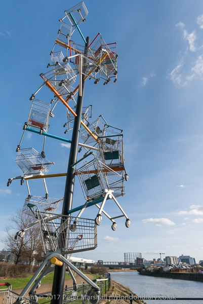
I paused briefly to photograph a sculpture made from shopping trolleys in a mock DNA double helix.
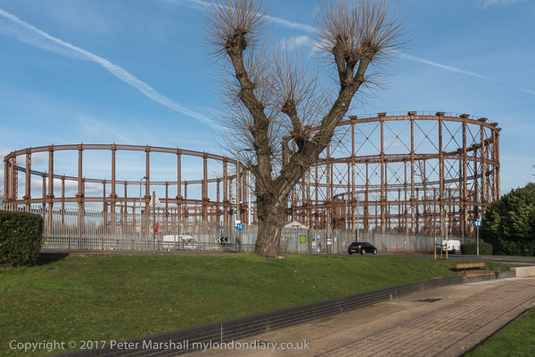
My next stop was to photograph the The Imperial Gas Light and Coke Co’s 1872-8 Bromley-by-Bow gasholders and the war memorials – originally at Beckton – with an eternal flame next to a monument to company workers killed in both World Wars.
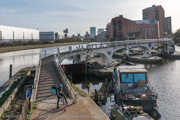
Steps leading down from Twelvetrees Bridge at Bow Locks took me down to the towpath beside the Lea Navigation.
Three Mills is a tide mill dating from 1776 (though on the site of earlier tide mills mentioned in the Domesday Book) on the Three Mills Wall River. It is the largest tide mill in the UK and the largest surviving in Europe.
Another sculpture on The Line, unveiled on the centenary on Three Mills Green and moved to this position on Short Wall is by Alec Peever and commemorates three men who died in 1901 They died going to the aid of a fourth who had been overcome by the lack of oxygen at the bottom of a well they were investigating.
I walked on to Stratford High Street, turning west to go to Bow Bridge and the Lea Navigation before going back beside St Thomas’s Creek and along Stratford High Street to the DLR Stratford High Street Station for the train to Canning Town.
More from Bow Creek
It was beginning to get a little dark as I came out from the station to photograph from the north side of East India Dock Rd.
This was still an industrial area although a large area seemed now to be unused. I thought it would probably not be long before this area too was covered in flats as I walked back to the station.
More around the Meridian – It’s seldom possible to actually walk for more than a few yards actually on the Greenwich Meridian in London and while planning my Meridian Walk I often wandered around considerably, having to make detours and also looking for the more interesting routes. So not all these images are exactly on the Meridian, but most were taken within a short distance from it.
When I began this project the Meridian was not marked on the Ordnance Survey or Street maps, and one of may first tasks was to get a ruler and pencil it on to them. In 1999 it was added to the OS maps of the area, but does not seem to be on the latest versions. In 1995 there were no smart phones with online maps and GPS which would have made things so much easier.
The Greenway was the recently rebranded path above the Northern Outfall Sewer which rans across East London from Hackney Wick to the sewage treatment plant at Beckton, going under the road here close the the bridge over Abbey Creek on the Channelsea River, where Abbey Lane becomes Abbey Road. You can see the bridge at the left of the picture.
Greenway, Channelsea River, Stratford, Newham, 1995, 95p4-1153
The Greenway is a great traffic-free cycle route for pedestrians and cyclists, running straight and level and this picture gives some evidence of that.
Channelsea River, Long Wall, Stratford, Newham, 1995, 95p4-1111
I’m not sure what this pipe was for, perhaps for taking gas across the river. Not far away on the other side of this tidal creek was one of the largest gas works in London – and you can still see its listed gasholders, though the view is likely to change soon with the site being redeveloped.
But behind me when I made this picture was the Abbey Mills sewage pumping station and on the edge of the creek below were the storm outfalls where sewage would be released after heavy rains. With the changing tides it would flow downstream a little and then could be taken miles upriver along the Prescott channel and the River Lea.
Flats, East India Dock Rd, South Bromley, Tower Hamlets, 1995, 95p4-1321
I think the Meridian went through the centre of the taller gas holder at Poplar Gas works.
Flats, East India Dock Rd, South Bromley, Tower Hamlets, 1995, 95p4-1321
Another view with the gasholders in the background.
Clove Crescent, East India, DLR, South Bromley, Tower Hamlets, 1995, 95p4-1273
My pencilled line for the Meridian shows it going through both the water in the dock and the brick building at left which was the former Blackwall Power Station in both of these pictures.
Clove Crescent, East India DLR, South Bromley, Tower Hamlets, 1995, 95p4-1263
South of the East India Docks the line crosses the River Thames above and between the two bores of the Blackwall Tunnel, closer to the original western tunnel now used by northbound traffic. I couldn’t take photographs in the tunnel – though it was possible for those on foot to take a bus across, but these would have been rather boring in any case.
This picture shows the southern entrance to the tunnel with its 1897 Grade II listed gatehouse by the London County Council’s Superintending Architect Thomas Blashill. In front of it a less ornate red and white striped arch with heigh and weight restriction signs and hangers to hit any overtall vehicles and hopefully prevent damage to the gatehouse.
One picture not I think actually on the Meridian but not far from it, taken from the long footbridge over the Blackwall Tunnel Southern Approach.
Riverside Path, Greenwich, 1995, 95p4-1762
My path continued south along the riverside path, with the Meridian going into the River Thames on the extreme left of this picture.
Riverside Path, Greenwich, 1995, 95p4-1742
I kept to the land continuing along a path I’ve walked many times and making a few more pictures.
Riverside Path, Greenwich, 1995, 95p4-1743
Like much of London’s riverside almost all of the industry has now gone, but some relics remain, though most of this part of my route is now lined by rather boring flats.
London Sawmills, Bow Creek, East India Dock Rd, Canning Town, Newham, 1989 89-4b-15
I walked back a few yards to the west along the East India Dock Road and made this picture looking south down Bow Creek, again showing the stacked timber on the wharf. The closer of the two bridges visible was I think just a pipe bridge, probably to carry gas from the nearby gasworks from Poplar to Canning Town, and has since been removed.
The second bridge is a Dock Road Foot Bridge, more commonly called the Blue Bridge (a name it shares with several others in London), though it also carries pipes and is still in place. I think it was intended to provide a route for people living in South Bromley to Canning Town station, and it leads to a bridge taking the footpath over the DLR, but unfortunately this has been almost permanently locked. It has been at least partly rebuilt since I made this picture
Hidden by this bridge a few yards further downstream and fenced off is another bridge, Canning Town Old Railway Bridge, long disused which was built to carry a single rail track over the river.
Pipe Bridge, Bow Creek, Tower Hamlets, Newham, 1989 89-4c-61
I walked on across Bow Creek and took this picture of the pipe bridge. As you can see it was well fenced off and although there were steps up and a footway across I could not access this.
All this brickwork on the Middlesex side of the river has gone, I think when the road bridge here was widened and a link road provided to the Limehouse Link tunnel but the brick abutment remains on the Essex side. The bridge was built to give sufficient clearance for navigation.
Pipe Bridge, Bow Creek, Tower Hamlets, Newham, 1989 89-4c-63
At the centre of the river I had crossed from Newham into Tower Hamlets. My street atlas names this area as South Bromley, but I don’t think anyone now knows where that is, as there is no station of that name, the DLR having decided on East India instead.
A few yards on along waste ground I made another picture showing the pipe bridge and the river, before turning back to the East India Dock Road. I made two exposures and I wonder if I may have chosen the wrong one to digitise as it is just slightly unsharp.
London Sawmills, Bow Creek, East India Dock Rd, Canning Town, Tower Hamlets, 1989 89-4c-65
Across the water you can see much of the planks produced by the sawmill on the wharf, as well as stacks on a further wharf downriver between the building around 50 yards away on land but half a mile downstream round what is now the Bow Creek Ecology Park. Behind the cut timber you can see part of the Pura Foods edible oils factory on the opposite bank of the invisible river, and above that the top of the flood barrier across the river on the other side of the factory.
Timber was for many years a major industry on Bow Creek and along the Lea Navigation, as the Surrey Docks just across the Thames was mainly a timber dock, with large timber ponds. Boats and barges would have brought huge trunks to sawmills such as this, and the cut timber was also mainly transported further on by barge.
Pura Foods, Bow Creek, Tower Hamlets, 1989 89-4c-52
I walked further east and used a short telephoto lens to make this image of Pura Foods. Their factory processing vegetable oils here at Orchard Place had grown considerably over the years, as had the smells from it, and many locals were pleased when the factory moved out in 2006.
Almost all of my pictures at this time were taken with a 35mm lens, giving a moderate wide angle view. The Olympus Zuiko lens I used was unusual in being a shift lens, allow me to move the optical elements relative to the film to give additional control over the perspective. It made it possible for example to photograph taller buildings without tilting the camera which would have resulted in verticals that converged.
Lens design has improved considerably since, and so have our expectations of lenses. Many of my pictures made then have a lack of critical sharpness at the corners which we would now find unacceptable. Digital imaging in particular means we now routinely look at images on a much larger scale on screen than the prints we used to make.
West Ham Power Station, Bow Creek, East India Dock Rd, Newham, 1989 89-4c-55
I crossed to the other side of the busy East India Dock Road, going along Wharfside Road under it, and made this view looking north up Bow Creek. As you can see the West Ham Power Station was then being demolished. This was the last in a number of power stations on the site since 1904, when West Ham Council built one here to power its trams. This was West Ham B, built in 1951 and it used coal brought up Bow Creek as well as coke from the neighbouring Bromley Gas Works.
Power production at the station dropped off from the late 1960s and it closed in 1983. By 1989 its two 300ft cooling towers had already been demolished and the rest of the station was following.
West Ham Power Station, Bow Creek, East India Dock Rd, Newham, 1989 89-4c-56
A second view shows more of the Newham (or Essex) bank south of the main power station building and the closer parts are again full of stacked timber.
Newham Council together with Tower Hamlets has plans for a number of new bridges in the area providing links across Bow Creek, at Lochnagar St, Poplar Reach near to Cody Dock and Mayer Parry connecting the Leven Road former gasworks site to roughly where the old power station was, now the SEGRO industrial park.
It had been a short and interesting walk and I made my way to Canning Town station for the slow journey home. Canning Town is much easier to get to since the Jubilee Line opened at the end of 1999.
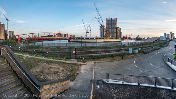
On Thursday 2nd March 2017 I had a meeting at Cody Dock about my photographic exhibition there later in the year. The weather forecast was good and promised me a day with blue sky and some clouds, perfect for my photography, particularly for some panoramas, where a clear blue sky or sullen grey overcast are both killers, so I rushed to get on an earlier train than I needed for the meeting to give time to take a walk along a part of Bow Creek before the meeting.
Years earlier there had been plans for a walk beside Bow Creek all the way from where it meets the Thames at Trinity Buoy Wharf up to the Stratford to join the tow path beside the Lea Navigation, but so far only some separate sections have materialised. The original plans envisaged two bridges taking the path across Bow Creek, and although a competition was organised (and won) for designs for one of these, neither had been built, largely because the money wasn’t there.
This section of the Leawalk has yet to open
Instead the plans were changed to make use of existing bridges, but vital riverside sections remain closed, either because of existing users of the land refusing access or because of new developments taking place in the area. One such development, that of London City Island has recently provided a new bridge which allows an alternative route to the mouth of the creek.
The red bridge built for London City Island
Part of the problem has probably been that the walk is along the boundary of two local authorities, Tower Hamlets and Newham, with sections in both.
Cody Dock
I walked one section before the meeting, but came to a locked bridge which led to a fairly lengthy detour, and ended up with me having to run along the West India Dock Road to catch the DLR to get to the meeting in time.
Cody Dock
There is currently no path between that road and Cody Dock which would have been a faster route for me. Instead I took the DLR from Canning Town one stop to Star Lane, from where a walk through an industrial estate took me to Cody Dock.
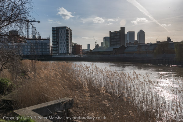
After the meeting I was able to rejoin the riverside path, now renamed the Leaway after I and many others made fun of its previous title as the Fatwalk, and made my way to Stratford.
One of the works on ‘The Line’
On my way I was pleased to find a newly opened link from Twelvetrees Crescent (named after a Mr Twelvetrees who built a bridge there to his factory) to the footpath between the river and the Lea Navigation, enabling me to avoid the rather nasty detour between here and the path via the horrendously busy Blackwall Tunnel Approach road.
This part of the Leaway is now walked much more, not least because if forms part of of ‘The Line’ sculpture trail, which rather roughly follows the Meridian from Greenwich to Stratford. But those following this still have, like me, to take the DLR or walk along busy and dusty roads from Canning Town to Cody Dock.
There was still plenty of daylight left by the time my wanderings took me to the DLR Stratford High Street station, where I entrained back to Canning Town for a few more pictures which both lack of time and the position of the sun had made impossible before my meeting. Then it was back to the station for the Jubilee Line back to central London.
My previous post, Around Devons Road, Bow 1988, ended outside Spratt’s Patent Limited on Morris Road on the south bank of the Limehouse Cut. My walk continued south down Chrisp St to the East India Dock Road, then turning east for around 350 yards and then back up the next main route north, St Leonards Road.
Plaque, George Lansbury, Poplar Councillors, East India Dock Rd, Poplar, Tower Hamlets, 1988 88-7t-66-positive_2400
This ‘blue plaque’ is actually and appropriately a red one, placed here by Tower Hamlets Environment Trust with the text ‘Near this place on July 29th 1921 George Lansbury led the people and councillors of Poplar on their march to the high court for the equalisation of rates to poor boroughs.’
According to a long article in Wikipedia, as a youth Lansbury was a supporter of the Liberal Party and particularly Gladstone, but while campaigning for the party he became greatly influenced by leading socialists including William Morris, Eleanor Marx, John Burns and Henry Hyndman, and resigned in 1892, joining the Social Democratic Federation. He worked for a short period as the SDF paid national organiser, leaving that job to return to Bow to take over the running of the sawmill owned by his wife’s family.
Lansbury was first elected to Poplar Borough council in 1903 and in 1910 became MP for Bow and Bromley. He resigned in 1912 in order to fight a by-election in the constituency standing as the ‘Women’s Suffrage and Socialist’ candidate, and although neither Labour nor Liberal parties put up candidates to oppose him he lost to a Conservative candidate with the name of Blair. Reginald Blair had campaigned under the slogan “No Petticoat Government”.
Earlier in 1912 Lansbury had campaigned with others to found a daily socialist newspaper, the Daily Herald, and became editor in 1914. Under his editorship the paper opposed the 1914-18 Great War with Germany and supported the 2017 Russian Revolution.
Lansbury and 29 fellow Poplar councillors were jailed in 1921 for refusing to pay unfair sums from the rates to fund the London County Council, Metropolitan police and other London-wide bodies, instead using the money to support the local poor. Their imprisonment led to public outcry and they were released after six weeks, with a law hastily passed to make richer London boroughs pay their fair share. The campaign made Lansbury a popular hero, and the following year he was elected as local MP with a large majority, holding the seat until his death in 1940.
From 1932 to 1935 Lansbury was the Leader of the Labour Party, but was forced to resign because his Christian pacifist principles became increasingly unacceptable as war with Germany and Italy looked increasingly inevitable. Ernest Bevin put in the final knife, pointing out at conference that his beliefs contradicted the party policy to oppose fascist aggression. Lansbury resigned a few days later, his deputy Clement Atlee becoming leader.
The Falcon, pub, East India Dock Rd, Poplar, Tower Hamlets, 1988 88-7t-51
The Falcon was at 202a East India Dock from 1869 until it closed in 1985. In my picture you can see some of the windows are boarded up inside and one in Bullivant Street is broken. The first building here was around 1819 and was owned by a Poplar wine merchant, so it may have been a pub earlier. The Truman, Hanbury & Buxton building in the picture dates from 1911 and was demolished shortly after I took this picture.
The A13 here has been widened and nothing on the south side of the road here remains. There are flats on the corner of Bullivant St, a few yards further south than the front of the former pub.
Chinese, East India Dock Rd, Poplar, Tower Hamlets, 1988 88-7t-52
I think this heavily metal shuttered frontage was a Chinese restaurant on the north side of East India Dock Road, probably in the block opposite Bullivant St. Unfortunately I can’t read the two Chinese characters but was intrigued by them and the hanging curtain behind them in this small aperture at the bottom of the doorway.
Tunnel Furnishers Ltd, East India Dock Rd, Poplar, Tower Hamlets, 1988 88-7t-53
Tunnel Furnishers, a furniture warehouse, was as few doors along East India Dock Road east from The Falcon pub on the corner of Bullivant St. A rather fine 1930s building, this was also lost in the widening of the road not long after I photographed it.
It looks rather like a cinema, but was built in 1938 for the Borough of Poplar as Electricity Showrooms and Offices, replacing an earlier showroom on the site. Closed in 1972, the upper floors continued to be used for training by the London Electricity Board until 1975, after which it was sold for commercial use. Like the rest of the block it was demolished in 1991.
My walk took me into what is now the St Frideswide’s Mission House Conservation Area, where a couple of days earlier I had photographed the Follett St Seamen’s Mission, and I took another, very similar picture of that building, before going further along the street and turning into Lodore St.
The view above is I think from Follett St, and shows the rear of one of the buildings of St Frideswide’s on Lodore St, but I think the archway, probably part of the chapel, has been demolished.
Christ Church, Oxford was originally the church of St. Frideswide’s priory, and St Frideswide’s Mission was set up by members of Christ Church College led by the father of Alice in Wonderland, Dean Liddell. A church was built here around 1892, with the Mission house opened in 1893, devoted to a girl’s and mother’s group.
The building was paid for by Miss Catherine Phillimore (1847-1929) , who I think was then well-known as an author as well as a translator of Italian books on artists, a wealthy spinster living at Shiplake House in Henley-on-Thames. A number of her books have been reprinted in recent years and are still available.
St Agnes House, 18, Follett Street Poplar, Tower Hamlets, 1988 88-7t-43
This was built to allow the work of the mission to expand in 1899, and also paid for by Catherine Phillimore. In 1900 it became the Hostel of the Poplar Association for Befriending Girls. The washing on the balcony shows it was still in use in 1988.
St Frideswide’s was the inspiration for the TV series ‘Call the Midwife’ and there is a good article on the Poplar London web site which praises the accuracy of the series and its depiction of the Religious Sisters of Saint John the Divine and their midwives, though complaining that it unfairly makes the residents of Poplar look dirty.
My walk will continue in a later post. You can see larger versions of the pictures by clicking on any of them, which will take you to the album where you can browse more.
Chaplain’s house, East India Company, Poplar High St, Poplar, Tower Hamlets, 198888-7p-31
The Survey of London has a long story about this house at 115 Poplar High Street, now a private residence oddly called Meridian House and built together with 26 new almshouses by the East India Company in 1801-2. They had first set up almshouses in Poplar for disabled and retired employees and their widows and orphans in1626, built partly using money seized from the estate of Hugh Greete after his death in 1619. Greete had been discovered to have been swindling the company while trading Indian diamonds and they seized his assets.
The old almshouse was demolished in 1802 replaced by the new buildings. After the Crown took direct control of India in 1858 the government took over these buildings as Poplar Marine Hospital, selling all except the chaplain’s house, burial ground and chapel to Poplar District Board of Works in 1866. They demolished the almshouses to become Poplar Recreation Ground.
The chapel became the Church of St Matthias with the Chaplains house as its vicarage – and it was further enlarged in the following years. When St Matthias was closed in 1976 the house was sold to become a private residence.
Former District Board of Works Offices, Poplar High St, Woodstock Terrace, Poplar, Tower Hamlets, 1988 88-7p-32
This Grade II listed building from 1869-70 for the Poplar District Board of Works was the result of a competition for designs which attracted 43 entries and considerable controversy when the prize went to Walter Augustus Hills (c1834–1917) and Thomas Wayland Fletcher (1833–1901) of Bow, both former assistant surveyors to the board. One architectual magazine at the time described it as ‘terribly ugly’. They were obliged to cooperate with the second place pair of Arthur and Christopher Harston over a final design. Once constructed the building was found to have various problems, not least that in the boardroom ‘reverberation was so excessive as to make the speaker almost incomprehensible’.
Various alterations were made and in 1900 the building became the town hall of the new Metropolitan Borough of Poplar, who extended it and then replaced it in 1038 by a new town hall in Bow. It continued in various uses by the council and in 1987 became the Borough of Tower Hamlets’s Directorate of Housing.
Poplar High St, Poplar, Tower Hamlets, 1988 88-7p-34
This small paved area is just off the High St between Norwood House and Holmsdale House and the block in the centre of the picture is Constant House on Harrow Lane, built by Poplar Council in 1936-7designed by the Borough Engineer and Surveyor, Rees J Williams. Both Holmsdale and Constant House were rehabilitated in 1986-7, with more work in recent years. Norwood House was added in the late 1960s and this paved area looks as if it may date from then.
Holmsdale House, Poplar High St, Poplar, Tower Hamlets, 1988 88-7p-36
A similar style block to Constant House, also built for Poplar Council in 1937-8, designed by Rees J Williams.
The Resolute, pub, Harrow Lane, Poplar, Tower Hamlets, 1988 88-7p-21
Built in 1937 on the corner of Poplar High St and Harrow Lane, to replace an earlier pub the Resolute survived until closed and demolished in 2011. The pub on this site was The Harrow from 1797 (or earlier) until renamed the Resolute Tavern around 1881.
The best-known ship of this name was fitted out for arctic service at nearby Blackwall Yard in 1850 and made several trips to the Arctic searching for the lost expedition of Sir John Franklin who had been searching for a North West Passage. Finally the Resolute got stuck in ice and was abandoned in May 1854, the crew escaping across the ice to a relief fleet.
The ship was found drifting by an American whaler over a thousand miles from where she was abandoned in September 1855 in perfect order and was sailed back to New London, Connecticut, arriving on Christmas Eve. Eventually she was bought by the US Congress, refitted and sailed back to be presented to Queen Victoria and rejoining the navy. The Resolute was retired from the Navy in 1879, possibly at the time the pub was renamed. Some of her timbers were then used to create a substantial desk presented by Queen Victoria to US President Rutherford B. Hayes in 1880. Moved out for some years it has been back in use by most presidents in the Oval Office since being replaced there by Jimmy Carter.
East End Snooker and Social Club, East India Dock Rd, Poplar, Tower Hamlets, 1988 88-7q-01
This club was at 253 East India Dock Road and has since been converted into Poplar Central Mosque.
The crunched rear end of D814 VRG presumably had its match on the front end of A506 DMX, but at least it appeared that there were no casualites in the collision at the north end of the Blackwall Tunnel, viewed by me from Poplar High St. A sign a little down the road says ‘Welcome to Tower Hamlets‘ though I think most of the tunnel is in the borough. At left is the unmistakable profile of Erno Goldfinger’s Balfron Tower, built in 1965-6 for the GLC and recently stolen from its residents by Poplar HARCA housing association and sold as luxury housing.
Just on the edge of the elaborate interchange between the East India Dock Road and the Blackwall Tunnel Approach is this small Seamen’s Mission, built in 1898 a Christ Church House and a part of the St Frideswide’s Mission House Conservation Area, but this building only locally listed. The mission here was set up by members of Christ Church College Oxford who in 1881 decided to support missions in the East End. Now converted into six flats.
My 1988 walk in Poplar will continue in a later post.