King’s Cross Road – 1989

My walk around King’s Cross on Saturday 8th April 1989 continues in this post. The previous part was Winged Lions, A School, Thameslink, Wine, Buses

Kings Cross Road, Lorenzo St, King's Cross, Camden, 1989 89-4d-32
Kings Cross Road, Lorenzo St, King’s Cross, Islington, 1989 89-4d-32

140-142 King’s Cross Road on the corner with Lorenzo Street had a distinct style to it, with the two oval windows and some interesting brickwork. British History Online states “This five-storey office block is largely of 1991 but incorporates the front and side elevations of a tenement building of 1888” and the view from where I made this picture is still much as it was before the rebuilding.

The two terracotta panels facing Lorenze Street are still there and together give the date of AD 1888. The BHO article suggests the architect was probably W. Youlle who was the architect for a similar building on Pentonville Road. The ground floor was occupied by shops – bricked up and fly-posted in my picture – with rooms and a toilet on each of the upper floors.

Almost legible in my picture is a line of text above what had been a shopfront on Lorenzo Street which appears to read ‘B R E E D O M E T E R S’ though some letters are unclear and part obscured by the no-entry sign. Perhaps someone will be able to clear up this mystery.

Leeke St, King's Cross, Camden, 1989 89-4d-33
Leeke St, King’s Cross, Camden, 1989 89-4d-33

The buildings at 5-11 Leeke St have become the offices for the Paul Hamlyn Foundation, established by Paul Hamlyn in 1987; after his death in 2001 this became one of the largest independent grant-making foundations in the UK. At left is a doorway with the date 1890 and an arm in armour holding the butt of a broken spear, the Irish Foster family crest for the Foster Parcel Express Co. The conservation area document describes it as “a microscope emblem”.

Kings Cross Road, King's Cross, Camden, 1989 89-4d-35
Kings Cross Road, King’s Cross, Camden, 1989 89-4d-35

These buildings are still there but their uses have changed and the café is now a property management company. The fine block at 150-158 was being refurbished in 1989 and is now home to an advertising agency.

Again British History Online is informative and suggests it was a speculative development. Built in 1902–3 with what it describes as a ” mildly ambitious” facade, it says that 154 and 156 had goods hoists and winches, though there is no sign of them in my picture.

Kings Cross Road, King's Cross, Camden, 1989 89-4d-36
Kings Cross Road, King’s Cross, Camden, 1989 89-4d-36

Again the BHO article linked above tells us that this was built as an office, workshops and stabling in 1899–1900 and was from many years occupied by J J Connelly who probably built it. The wide doorway at left was for horses with a ramp leading up to stables on the upper floor. It was apparently still being refurbished when I made this picture as offices for Community Service Volunteers. The structure is still there but looks rather different as the striped window shades have been removed and the frontage painted a uniform white.

The taller building at right was the Mary Curzon Hostel for Women, built in memory of his wife for Lord Curzon in 1912-3 to provide inexpensive hostel accomodation for working women. Again there is a fuller description in the BHO article. When it was taken over by the LCC in 1955 it was renamed the Susan Lawrence Hostel.

Dodds the Printers, Kings Cross Road, King's Cross, Camden, 1989 89-4d-24
Dodds the Printers, King’s Cross Road, King’s Cross, Camden, 1989 89-4d-24

Dodds the Printers had these shopfronts at 193-5 on King’s Cross Road for many years and their signage shown looked like something from a different age in 1989. From around 2013 the shopfronts have been put to other uses but the printers still appear to be in business at the rear of the premises down St Chad’s Place, the alley through the doorway in this picture. I’d taken a few photographs in this alley in 1986, which show the signs for Dodds on the back of their property.

Kings X Radio Cars, Kings Cross Road, Kin Pentonville Rd, King's Cross, Islington, Camden, 1989 89-4d-11
Kings X Radio Cars, Pentonville Rd, King’s Cross, Islington, 1989 89-4d-11

I turned left onto Pentonville Road, and took a picture of these shops on the north side of the road, all of which are now a Pizza Restaurant, though not the same Italian snack bar as in my picture.

There is still a clock high more or less in the same position though that blank wall has now got four windows. The rectangular clock permanently at three minutes past four which had I think once advertised a businness here has been replaced by a slightly bulky circular one which appears to change with the hours.

I walked a few yards west and tuned right up Caledonian Rd where the next post on this walk will begin. The first post on this walk was Kings Cross, St George’s Gardens & More.


Winged Lions, A School, Thameslink, Wine, Buses…

My walk on Saturday 8th April 1989 continued. The first (and previous) part was Kings Cross, St George’s Gardens & More.

Carving, Willing House, Gray's Inn Rd, King's Cross, Camden, 1989 89-4d-63
Carving, Willing House, Gray’s Inn Rd, King’s Cross, Camden, 1989 89-4d-63

Close to the north end of Gray’s Inn Road, at 356-364 on the corner with St Chad’s Place, is a remarkable early 20th century building in a style described as French Baroque, Willing House, built in 1909 as offices for Messrs Willing Advertising, architects Alfred Hart and Leslie Waterhouse. It’s Grade II listing is perhaps deserved more for the carvings on its facade by William Aumonier Junior, than its rather quirky style.

On the peak of its roof, not shown in these pictures, though appearing rather small on another not digitised, is Mercury, a sculpture by Arthur Stanley Young. According to Wikipedia, Mercury “is the god of financial gain, commerce, eloquence, messages, communication (including divination), travelers, boundaries, luck, trickery, and thieves“, most of which seem appropriate for one of London’s major advertising companies.

This bas-relief by Aumonier, one of a pair, shows one man blowing a long trumpet and another more obvious with a horse, though what he is supposedly doing to the poor beast is unclear. Above them is a highly stylized sun.

Doorway, Willing House, Gray's Inn Rd, King's Cross, Camden, 1989 89-4d-64
Doorway, Willing House, Gray’s Inn Rd, King’s Cross, Camden, 1989 89-4d-64

This is the ornate main doorway to the building, with giant winged lions on the pilasters at each site. Above them is a frieze with one old man holding a globe and another blowing a trumpet, and Aumonier has thrown in a few cherubs for good measure.

London Details provides a great deal of information about Willing and Co, founded in 1840, and this building. There is also an unusually long description in its Grade II listing.

Winged Lions, Willing House, Gray's Inn Rd, King's Cross, Camden, 1989 89-4d-65
Winged Lions, Willing House, Gray’s Inn Rd, King’s Cross, Camden, 1989 89-4d-65

A closer view of one of the two winged lions. In 1989 this building was apparently in use by Camden Council but has since been converted into a hotel. Mercury on the roof has also recently been given a comprehensive makeover, repainted to his original grey and his caduceus regilded.

King's Cross Thameslink, Railway Station, St Chad's Place,  King's Cross, Camden, 1989  89-4d-52
King’s Cross Thameslink, Railway Station, St Chad’s Place, King’s Cross, Camden, 1989 89-4d-52

The railway runs under part of Willing house and the unfortunate guests may get a room overlooking the lines, which carry Thameslink between Kings Cross and Farringdon. Railway nerds might welcome this but I hope for others the soundproofing is effective.

This site had been opened as King’s Cross Metropolitan in 1863, on London ‘s first underground line, and a second pair of lines added in 1868. The platforms for the Metropolitan, also serving the Circle and Hammersmith & City Lines, were closed and replaced by some a little nearer King’s Cross in 1940, but the station remained in use. It was rebuilt and opened here in 1988 as King’s Cross Thameslink. It closed for good in 2007 and Thameslink trains now stop at new platforms somewhere in the bowels of Kings Cross and St Pancras.

Former Church School, Brittania St, Wicklow St, King's Cross, Camden, 1989 89-4d-41
Former Church School, Brittania St, Wicklow St, King’s Cross, Camden, 1989 89-4d-41

This Grade II listed Church School built in 1872, its architect Joseph Peacock who had previously designed St Jude’s Church, the first church to be constructed in London using monies from the Bishop of London’s Fund, which was consecrated in 1863. In June 1936 the parish was united with with Holy Cross, Cromer Street and the church was demolished with many of its memorials being moved to Holy Cross. The school became offices.

Brittania Wine Warehouse, Britannia St, King's Cross, Camden, 1989 89-4d-43
Brittania Wine Warehouse, Britannia St, King’s Cross, Camden, 1989 89-4d-43

This building now has a sign in stone I think revealed by the removal of that for the Brittania Wine Warehouse ‘LONDON GENERAL OMNIBUS COMPANY LIMITED’. The company was founded in 1855 and remained the main bus operator in London until 1933. It was originally an Anglo-French company, the Compagnie Generale des Omnibus de Londres, and now we once again have many buses in the capital run by a French company, London United being a part of the French state-owned RATP ( Régie autonome des transports parisiens.)

This was the horse bus depot of the LGOC, and later their motor bus depot, and their last late horse-drawn bus ran in 1911.

Derby Lodge, Britannia St, King's Cross, Camden, 1989 89-4d-45
Derby Lodge, Britannia St, King’s Cross, Camden, 1989 89-4d-45

Derby Lodge, Grade II listed philanthropic flats from erected around 1865 for Sydney Waterlow’s Improved Industrial Dwellings Company with the help of builder Matthew Allen. Grade II listed. Listed in the 1990s and since refurbished.

Like other similar flats of the era their design was based on the model cottages erected for Prince Albert as a part of the 1851 Great Exhibition in Hyde Park and later re-erected in their current location in Kennington Park where they still are.


Kings Cross, St George’s Gardens & More

The day after my short trip to Canning Town the weather was again looking good and so on Saturday 8th April 1989 I was out again walking and taking pictures. This time my starting point was King’s Cross St Pancras Underground Station (not then International.)

Kings Cross, Lighthouse, Pentonville Rd, Gray's Inn Rd, Islington, Camden, 1989 89-4c-41
Kings Cross, Lighthouse, Pentonville Rd, Gray’s Inn Rd, Islington, Camden, 1989 89-4c-41

Immediately on coming out of the station I crossed the Euston Road and took a photograph looking across the busy junction between Pentonville Road and Grays Inn Road. Later this was to be transformed into the death trap for cyclists it now is, after the road engineers were told to ignore cyclists in planning the junction, and I’ve photographed a number of protests there. In the past ten years at least three cyclists have been killed and 15 seriously injured here.

Back in 1989 before the redesign it was almost certainly safer, as traffic here was usually moving rather more slowly – and in my picture I think is at a complete standstill.

The building at the centre of the image is the famous “lighthouse” whose presence has invited a litany of stories, almost all empty fabrication and speculation. But it seems that it was built between 1875 and 1885 to promote Netten’s Oyster Bar then doing a roaring fast food service at street level. Later the block became home to one of London’s best known jazz record stores, Mole Jazz, which opened at 374 Gray’s Inn Road in July 1978 – and I became one of its early customers, though I had given up buying records long before it closed in 2004.

The lighthouse seems in decent condition in my picture, but more recently deteriorated and became covered in graffiti. The building has recently been refurbished as the Lighthouse King’s Cross office space, with a top floor bar and roof terrace around the lighthouse itself.

Kings Cross Station, Euston Ed, Camden, 1989 89-4c-42

I turned around and took another picture, looking back at Kings Cross Station across Euston Road. The view here remained much the same until around 2021 when the more recent buildings in front of the 1851-2 station building, designed by Lewis Cubitt, the younger brother of both Thomas Cubitt responsible for much of London’s nineteenth century housing and William Cubitt, another important developer, who gave his name to Cubitt Town on the Isle of Dogs and later served two consecutive terms as Lord Mayor of London.

The station building is Grade I listed, and the recent changes have I think greatly improved it.

St George's Gardens, Sidmouth St, Camden, 1989 89-4c-32
St George’s Gardens, Sidmouth St, Camden, 1989 89-4c-32

There are many parts of London which it is hard to assign a name to, and the one I was walking around on this Saturday was one of them. My street atlas calls it ‘St Pancras’, I think it is part of Camden’s King’s Cross Ward, and when I’ve often walked across it from Tavistock Square I’ve always thought of it as Bloomsbury. Wikipedia has a rather lengthy discussion which says in part “Bloomsbury no longer has official boundaries and is subject to varying informal definitions, based for convenience“.

St George’s Gardens began in 1713-4 as a joint burial ground for St George-the-Martyr, Holborn (in Queen’s Square, now known as St George’s Holborn) and St George’s Bloomsbury and still has a line of stones marking the division of the area between the two churches, both of which had run out of space for burial in their churchyards. It was one of the earliest London burial sites situated away from the churches it served.

St George's Gardens, Sidmouth St, Camden, 1989 89-4c-34
St George’s Gardens, Sidmouth St, Camden, 1989 89-4c-34

But people kept on dying, and where buried here, mainly in unmarked graves. By 1885 there was no more room, and it was closed for burials. As a consecrated burial ground it could not be built on and burial grounds such as this were fast becoming the only open spaces in central London. “Campaigners including Miranda Hill and the Kyrle Society and Octavia Hill fought to create ‘outdoor sitting rooms’ to ‘bring beauty home to the poor’. St George’s Gardens were opened in 1884.”

St George's Gardens, Sidmouth St, Camden, 1989 89-4c-33
St George’s Gardens, Sidmouth St, Camden, 1989 89-4c-33

I made ten pictures here, of which three are online. The Friends of St George’s Gardens say that by 1997 the gardens were very run down, though I don’t think this is apparent in my pictures which show neatly cut grass and generally well-tended areas. The Friends were formed in 1994 when they say there had been a “prolonged period of neglect” and the gardens have been restored since then, with a lottery grant in 2001 and other and continuing work by the Friends.

Houses, Frederick St, Camden, 1989 89-4c-12

Frederick Street was one of those developed by Thomas Cubitt and Numbers 48-52 date from 1815-1821, a few years earlier than some of the other Grade II listed houses on the street. Before making this picture I’d also photographed (not online) on of his terraces in Ampton Street, parallel and a few yards to the south. Both run east from Greys Inn Road, where in later years I often visited the NUJ offices on the corner with Acton Street.

Royal National Throat, Nose and Ear Hospital Swinton St, Camden, 1989 89-4c-16
Royal National Throat, Nose and Ear Hospital Swinton St, Camden, 1989

Walking north up Greys Inn Road past the NUJ offices (now at ground floor Bread&Roses @ The Chapel Bar) the next corner a few yards on is Swinton Street, and a few yards down there is this five floor frontage of the Royal National Throat, Nose and Ear Hospital towering above the fairly narrow street.

This hospital remained in use until March 2020, when it was closed a few months earlier than planned due to Covid-19. Until then it was still offering inpatients ear, nose and throat (ENT) and oral surgery, sleep diagnostics and allergy day case services.

The hospital had been set up in 1874 as the Central London Throat and Ear Hospital by two doctors who had previously worked at the first specialist throat hospital in the country, the Hospital for Diseases of the Throat in Golden Square.

The hospital’s original building was begun on the Grays Inn Road in 1875, and various other buildings and wards were later added, with the hospital eventually covering a large site between here and Wicklow St. This rather odd building on Swinton Street was the Nurses’ Home, built in the 1930s.

More about my walk in later posts.


Bow Creek, East India Dock Way, April 1989

I only had time for a short walk on Friday 7th April 1989, cycling home furiously from the college where I was teaching at noon as I had no afternoon classes, picking up my camera bag and rushing to catch a train into London.

Essex Wharf, Bow Creek, Pura Foods, Wharfside Rd, Canning Town, Newham, 1989 89-4b-31

Canning Town, where I was heading, was on the other side of London and not then the easiest of places to get to before the DLR and Jubilee lines were completed. My journey involved a slow transit around North London on the line from Richmond on the North London Line to the old Canning Town station immediately north of the A13 East India Dock Road, next to Stephenson Street.

Bow Creek, East India Dock Way

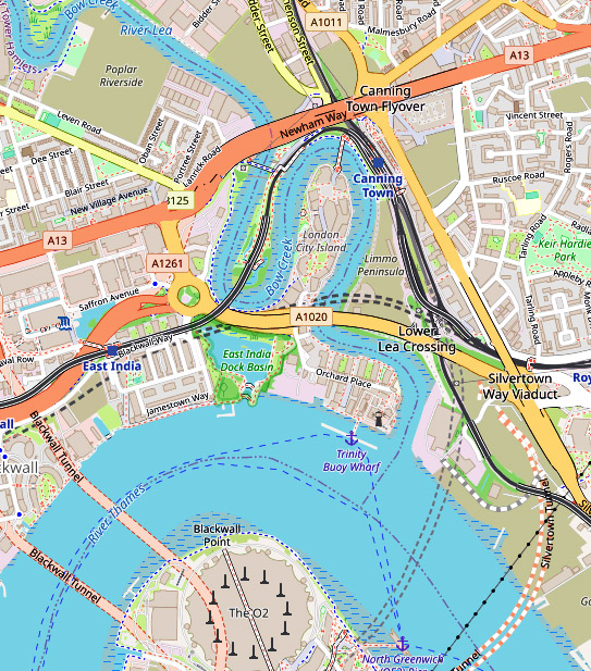
If you are not familiar with the geography of this area, a small clip from OpenStreetMap, slightly enhanced, will help. The East India Dock Road on this map is labelled Newham Way, which is here a flyover above the road itself. The former station I used was just to the north of this. Pura Foods was inside the loop which is now London City Island and there was no bridge across the river at the top of the bend.

Essex Wharf, Bow Creek, Pura Foods, Wharfside Rd, Canning Town, Newham, 1989 89-4b-34
Essex Wharf, Bow Creek, Flood Barrier, Pura Foods, Wharfside Rd, Canning Town, Newham, 1989 89-4b-34

A subway close to the station entrance took me to the other side of this busy road, where I had a view of Bow Creek, northern end of its loop dominated by Pura Foods, looking across waste ground where the DLR would shortly run. The flood barrier on Bow Creek became redundant when the Thames Barrier was built.

Essex Wharf, Bow Creek, Pura Foods, Wharfside Rd, Canning Town, Newham, 1989 89-4b-35

I moved slowly west along the East India Dock Road, stopping to take occasional images. There was a considerable amount of waste including old tires dumped here, but it was also a working industrial area, with workers cars parked alongside the river.

Essex Wharf, Bow Creek, Pura Foods, Wharfside Rd, Canning Town, Newham, 1989 89-4b-26
Essex Wharf, Bow Creek, Pura Foods, East India Dock Rd, Canning Town, Newham, 1989 89-4b-26

The main business on this side of the river appeared now to be the sawmill, though I also photographed the sign board for Haughton Engineering, but I’m unsure whether they were still in business.

Bow Creek, Pura Foods, Wharfside Rd, Canning Town, Newham, 1989  89-4b-11
Bow Creek, Pura Foods, Wharfside Rd, Canning Town, Newham, 1989 89-4b-11

It seemed to me an area which cried out for some panoramic images, and I took a set of three overlapping handheld pictures – the left of the set above – intending to combine them – which back then would have involved cutting and pasting the three together, but later I found I couldn’t quite get them to match up. Even when it became possible to do this digitally I found I hadn’t quite made these precisely enough.

Bow Creek, Pura Foods, Wharfside Rd, Canning Town, Newham, 1989 89-4b-12

It was experiences like this that led me a couple of years later to save up and buy a proper panoramic camera – I think the first one cost me around a month’s wages.

London Sawmills, Bow Creek, Wharfside Rd, Canning Town, Newham, 1989 89-4b-13

I continued walking west, the road on a low viaduct giving me a good view of the area to the south, coming to a timber yard where Bow Creek flowed into the area, going down south towards Orchard Place before turning north to go back towards the East India Dock Road where I had taken the earlier images.

London Sawmills, Bow Creek, East India Dock Rd, Canning Town, Newham, 1989 89-4b-15

I’ll post about the second and final part of this short walk later.


Highgate, Swains Lane And Dartmouth Park, April 1989

This is the second and final part of my walk on Friday 7th April 1989 which had started at Gospel Oak station and I had walked up to Highgate. You can read the first part at Highgate April 1989.

Highgate Literary, Scientific Institution, South Grove, Highgate, Camden, 1989 89-4a-11

I took another picture of the Highgate Literary & Scientific Institution, but didn’t explore much more at the top of the hill.

Pond Square, Highgate, Camden, 1989 89-4a-22

Though I did take a few more pictures, but have only digitised this one. I was eager to go down the hill again, this time taking Swain’s Lane, by the side of the Literary & Scientific Institution.

Swain’s Lane is rather steeper than West Hill and apparently had got its name from being used by pig herders and was first recorded in writing as Swayneslane in 1492. It provided access to farms on either side and only the top few yards were developed for housing before 1887. Fortunately I was walking down hill and hadn’t brought my bike as riding up this lane would have been something of a challenge.

House, Swains Lane, Highgate, Camden, 1989 89-4b-63
Lodge, Swain’s Lane, Highgate, Camden, 1989 89-4b-63

Even now much of Swain’s Lane is undeveloped as it runs between one of London’s great cemeteries, Highgate Cemetery and one of its fine parks, Waterlow Park, both behind brick walls with just a narrow pavement. Below Waterlow Park on the east side is the newer part of Highgate Cemetery, which includes Karl Marx’s Tomb.

The Grade II listed building is the picture is the Lodge at the Swain’s Lane entrance to Waterlow Park, built in the mid-19th century in a fine example of Victorian Gothic, though the chimneys are more Tudor. The post at right is for the park gate and I took just a brief stroll inside before continuing my walk. On warmer days I’ve explored the park rather more and sometimes found a bench to eat my sandwiches as well as taking a few pictures.

In 1992 I visited and took some pictures in both the West and East parts of Highgate cemetery, some of which are on-line in Flickr, but on this walk I didn’t have time to stop and just went on down the hill.

House, Swains Lane, Oakeshot Ave,  Highgate, Camden, 1989 89-4b-52
Mansion, Swains Lane, Oakeshot Ave, Highgate, Camden, 1989 89-4b-52

Immediately south of the West cemetery is the Holly Lodge Estate, with mansion blocks on Makepeace Avenue and Oakeshott Avenue. The website tells that in 1809 Harriot Mellon, a young actress acquired a large villa later known as The Holly Lodge here, and after she married banker Thomas Coutts in 1815 both house and grounds were enlarged and landscaped. She died in 1837, leaving the property and her fortune to one of the most remarkable women of the Victorian age, her husband’s ganddaughter, Angela Burdett-Coutts.

When she died in 1906 her husband tried to sell the entire property with no success, but then managed to sell off some of the outlying parts – including Holly Terrace on West Hill and South Grove House, both mentioned in the previous post on this walk but it was not until 1923 that the main part was sold off and development of the Holly Lodge Estate began.

This area was acquired by the “Lady Workers’ Homes Limited to build blocks of rooms and flats for single women moving to London in order to work as secretaries and clerks in the city on the Eastern side of the estate.

These blocks built in the 1920s had fallen into a poor state of repair by the 1960s and were acquired on a 150-year lease in 1964 by the Metropolitan Borough of St Pancras – and so are now owned by the London Borough of Camden. The council for some years continued with the policy of only housing women on the estate but this has now lapsed.

The flats were designed without separate kitchens and with shared bathrooms and toilets as bed-sits for single women – and the estate was built with a long-demolished community block with restaurant, reading and meeting rooms and a small theatre, and behind it three tennis courts. Some of the bed-sits have been converted into self-contained flats but others still share facilities.

Raydon St, Dartmouth Park Hill, Highgate, Camden, 1989 89-4b-42

I returned to Waterlow Park, making my way through it to Dartmouth Park Hill and on to take thsi picture of some very different housing on the Camden’s Whittington Estate. But by now I was in a hurry and the light was fading a little and I took very few photographs (none online) as I made my way through the streets of Dartmouth Park to Highgate Road and Grove Terrace and on to Gospel Oak station for my journey home.


Highgate April 1989

Friday 7th April 1989 was at the end of my Easter break from teaching and I took the opportunity to take a walk in North London, taking the North London Line from Richmond to Gospel Oak.

Nautilus Fitness, Advertising, Sinclair C5, Highgate Rd, Dartmouth Park, Camden, 1989 89-4a-54
Nautilus Fitness, Advertising, Sinclair C5, Highgate Rd, Dartmouth Park, Camden, 1989

I walked up to Highgate Road where I found this unusual form of advertising, with a Sinclair C5 piggy-backing on a Datsun. On the back of the C5 were these two boards, one with a woman’s face at the top.

The C5 was doomed from the start and it’s hard to understand why any competent businessman had ever thought it could succeed. Recumbent bicycles have never attracted wide ownership despite their mechanical advantages; perhaps if there were no cars, lorries, buses etc on our road they might have done so. And the C5 was just a recumbent trike with an electric motor and some plastic bodywork.

It’s low viewpoint made driving in traffic unsafe, the bodywork gave little or no protection, the carrying capacity was one person and virtually no other load and its range – even if it could have made the promised 20 miles – too low. And with a top speed of only 15mph and little protection from the weather. Only 5000 were sold before the company failed, although the unsold stock later became a cult item for off-road use and often substantial modifications – with some re-engined and souped up to 150 mph.

Houses, Highgate Rd, Dartmouth Park, Camden, 1989 89-4a-55

These substantial houses just south of St Alban’s Road now have lost the dark finish which provided a contrast on the upper floors. The wide gateway under the ventre of the two linked blocks leads through to Oak Court, a post war block. perhaps from the 1960s presumably built by St Pancras Council in the gardens of these houses behind St Albans Villas with a vehicle entrance from St Albans Rd.

Houses, Highgate West Hill, Highgate, Camden, 1989 89-4a-41

Highgate Road ends at Swains Lane, but Highate West Hill continues in the same direction, and walking up it you notice the hill. The large semi-detached house in the foreground is No 23 and you can see that No 27 is a few feet higher up the hill. Some of the other houses in this row have similar tiled decorations to those on No 25 at the middle of the picture and I imagine all once did. Just a little further up is No 31 where John Betjaman grew up.

Wall, Highgate West Hill, Highgate, Camden, 1989 89-4a-45
Wall, Holly Terrace, Highgate West Hill, Highgate, Camden, 1989 89-4a-45

It’s quite a low walk uphill, and much of the road is lined with fences and trees which hide the houses behind, and I made few pictures. Nearing the top of the hill you can still see this wall with an unusual curve at 1 Holly Terrace and that rather crazy tree as well as the fine house is still there too. These houses date from around 1807, built on the site of an older property.

House, Highgate West Hill, Highgate, Camden, 1989 89-4a-33

The hill continues upwards, with this slightly odd villa at No 80, looking to me rather like a German toy house. Beyond it you can see South Grove House and the spire of St Michael’s Church in South Grove, the highest church in London, architect Lewis Vulliamy (1791-1871), consecrated in 1832 and one of the earliest neo-Gothic churches.

It was one of 600 new churches built following the 1818 passage of An Act for the Building and the Promotion of Building Additional Churches in Populous Parishes. It was actually completed nine months before it could be consecrated, having been completed in something of a record time of 11 months, but another Act of Parliament had to be passed to allow its consecration as “The land on which it was built was from the parish of St Pancras, which was a peculiar under the jurisdiction of the Dean and Chapter of St Paul’s Cathedral.”

Highgate Society, Highgate Literary, Scientific Institution, South Grove, Highgate, Camden, 1989 89-4a-21

In South Grove I made this picture of the Highgate Literary & Scientific Institution, which has the date 1839 above it. The building was earlier, having previously been a school, and the building got a new porch and frontage in the 1880s. Such institues were common during the 19th century before the establishment of public libraries, but few now remain still offereing “opportunities for life-long learning through its courses, library, archives, art gallery, lectures, debates, cultural and social events.

More on this walk in a later post.


Brick Lane and Tubby Isaacs

Brick Lane and Tubby Isaacs is the third and final part of my walk which began with A Walk In the City – March 1989. The previous post was Shops, Soup Kitchen, Spitalfields 1989.

Posters, Brick Lane, Spitalfields, Tower Hamlets, 1989 89-4a-01

Hanging on the wall outside the Mosque on Brick Lane were a number of posters for sale showing various aspects of the Muslim World.

As is widely known, the mosque – which I’ve photographed on various occasions so didn’t bother on this walk – has a long a varied history since it was built in 1743 as La Neuve Eglise for the Huguenots who had come to the area as refugees from persecution by Catholics in France.

In 1809 is became a Methodist chapel for the London Society for Promoting Christianity Amongst the Jews, changing ten years later to a more mainstream Methodist chapel.

In 1898 it became the Spitalfields Great Synagogue for the Machzike Hadath communty of Lithuanian heritage, one of several large synagogues in the area. Not far away in Aldgate was the Great Synagogue of London (destroyed in wartime bombing) as well as the Sandys Row Synagogue and there were others in the area. After over 70 years the Machzike Hadath moved in 1970 to Golders Green where most of the community now lived.

The building was bought and refurbished by Bangladishis, by then the main community in the area, and opened as a mosque for in 1976 as the London Jamme Masjid. Friday sermons are in Bengali, English and Arabic and the Grade II listed building can accomodate over 3,000 worshippers.

Horse & Cart, Brick Lane, Bacon St, Spitalfields, Tower Hamlets, 1989 89-4a-02
Horse & Cart, Brick Lane, Bacon St, Spitalfields, Tower Hamlets, 1989

I continued north up Brick Lane and was surprised to see this workmanlike horse-drawn cart crossing the street and going up Bacon Street, pulled by a rather resigned-looking small working horse.

I hadn’t seen something like this since I was in short trousers back in the early 1950s. There were still some breweries using horse-drawn drays, mainly for publicity but those were much grander affairs with huge Shire horses. This was a rather smaller and more crude heavy-duty construction, almost home-made compared to the highly finished examples my father worked on in his father’s workshop as a young man.

Probably you are more likely to see horse-drawn vehicles in London now than back in the 1980s, but these are either the grand carriages such as those used on occasions such as the Lord Mayor’s show or light traps in which a few mainly travellers occasionally come in from the countryside for a sporting Sunday ride around the capital.

Surplus Centre, Brick Lane, Bethnal Green Rd, Spitalfields, Tower Hamlets, 1989 89-4a-61

The buildings on the corner of Brick Lane and Bethnal Green Road still look much the same, at least above the ground floor, where the shops are now rather less interesing than the Surplus Centre, dealing as it states in ‘Government Surplus Clothing & Camping Equipment, JEANS, Trousers, Combat & Donkey Jackets, Leather & Fur Lined Jackets, Motor Cycle Clothing, Anoraks, Shirts, Gloves, Tents & Everything For Camping’

Pool Room, Hanbury St, Brick Lane, Spitalfields, Tower Hamlets, 1989 89-4a-64

Although the small print helpfully informs me “126 Brick Lane & 45-B Hanbury St Prop Contessa-Restaurants Ltd‘ and gives telephone numbers its difficult to recognise this location now, though I think the two doorways are still present if no longer in use on a graffitt-covered brick wall which has lost its upper storey, just a few yards east of Brick Lane on Hanbury St.

The first Indian Restaurant in Brick Lane was The Clifton, a cafe which opened in 1959 by Musa Patel, a Pakistani migrant to the UK in 1957, named after the wealthy seaside suburb of Karachi where he had been born in 1936.

In 1974 he made it into Brick Lane’s first licensed restuarant, later renamed The Famous Clifton. It was the first restaurant on the street to use a tandoori oven, and the first to attract customers other than the local Bangladeshi clientele and thus begin the transformation of Brick Lane. It closed soon after Musa Patel’s death in 1996.

H Suskin, Textiles, Brick Lane area, Spitalfields, Tower Hamlets, 1989 89-4a-65

H Suskin Textiles Ltd had a workshop in Wilkes St and are said to have had a shop at 45 Wilkes St, since demolished. This is very clearly at Number 45 so I think this is probably it. They also had a shop at 79 Brick Lane.

At the top of the flyposted window shutters are political posters in Bengali and English asking for votes for Mohammad Huque and Syed Islam in the local elections. Below that are three adverts for Gurdas Maan Nite, an Indian musical event starring the famous Indian Punjabi singer, songwriter & actor, probably on film.

At bottom right are adverts for an expensive Dinner and Dance in August 1988 at the London Hilton, but the largest space is taken by posters ‘Hands Off Afghanistan‘ advertising New Worker public meetings in Manchester, London, Birmingham, Liverpool and Sheffield calling for support for the People’s Government left in charge when the Russians withdrew and for an end to UK support by MI6 and the SAS of the Mujahideen. The New Worker is the weekly newspaper of a 1977 splinter group, the New Communist Party of Britain, from the Communist Party of Great Britain which among other differences had been opposed to the 1966 renaming of the Daily Worker as the Morning Star.

Tubby Isaacs, Sea Food Stall, Goulston St, Whitechapel High St, Aldgate, Tower Hamlets, 1989 89-4a-66

I walked on down Brick Lane and Osborne Street to Whitechapel High Street and then back towards the City. On my way I passed the corner with Goulston Street where until 2013 you could still see the world famous Tubby Isaacs sea food stall.

Isaacs was founded by Isaac Brenner in 1919, and when he emigrated to the USA in 1939 to avoid conscription it was taken over by Solomon Gritzman. He had a brother Barney who set up another stall opposite and the two were bitter rivals for many years – I think the ‘We Lead – Others Follow‘ was a reference to his brother. When Solly died in 1975 the business passed to his nephew Ted Simpson who had worked with him.

My picture shows his son Paul who had just taken over, having worked with his father since he was 14. In 2013 he decided it was time to close the stall as most of its customers had died. I don’t know where this gang of children came from but I don’t think they were about to buy anything back in 1989.

I made my way back to Bank for the train home, pausing only briefly for yet another picture of the recent Lloyd’s building, not digitised.


Shops, Soup Kitchen, Spitalfields 1989

Continuing my posts about my London walk which began with A Walk In the City – March 1989. The previous post was Men At Work, Cherubs, Trees and More.

Intercity (East) Ltd, Clothing, Shop, City, Tower Hamlets, 1989 89-3e-42

I was on my way to the East End, and I’m no longer sure where this shop was located, although my contact sheet has Cutler Street, it also has a question mark in front of this. I will have marked up the contact sheets while I still remembered my route (and had probably marked this on a map more or less after I got home) so I will have walked this way towards Leyden Street where I made the next picture. But all I can find on Google about Intercity (East) Ltd is not about clothing stores but trains.

Cutler Street begins on Houndsditch and I think both corners there have been demolished and rebuilt since 1989. It has two more corners where it turns 90 degrees to the right in front of Cutlers Gardens, again both now occupied by more recent buildings.

Cobb St, Spitalfields, Tower Hamlets, 1989 89-3e-43
6-10 Cobb St, Spitalfields, Tower Hamlets, 1989 89-3e-43

From Cutler Street I went up Harrow Place and crossed over Middlesex Street into Cobb Street, going out from the City of London into Tower Hamlets. Much of the area I went through has since been redeveloped but unfortunately I took no pictures.

Blue Bird, Childrens Wear, Cobb St, Spitalfields, Tower Hamlets, 1989, 89c03-04-71

Blue Bird, a wholesale children’s clothing cash and carry was a shopfront I also photographed in colour on this same walk. This building remains, though was extensively renovated internally around 2020 and 6 at right, Dunmow Trading, is again apparently in the clothing trade, though perhaps the renewed shopfront is a nod to the past hiding some completely different activities.

Brune St, Spitalfields, Tower Hamlets, 1989 89-3e-22

This was a frontage I passed and photographed several times over the years, but never went inside. Founded in 1854 in Leman St, the Soup Kitchen for the Jewish Poor moved to Brune Street (then Butler St) in 1902 and eventually closed in 1992, its work being carried on by Jewish Care in Beaumont Grove, Stepney. I had assumed it was now longer operating when I took this picture in 1989.

Shopfront, Fournier St, Spitalfields, Tower Hamlets, 1989 89-3e-11

Another shopfront I photographed on several occasions and in colour, and it was hard to decide which if any of the businesses were still in operation. Now the whole area has been tidied up and shops like these converted to slightly twee ‘period’ residential properties.

This early 18th century Grade II listed terrace house was sold in 1998 for £236,000, probably just before or after conversion, and in 2021 sold for £3.5million.

Christ Church, Fournier St, Spitalfields, Tower Hamlets, 1989 89-3e-13

The fine row of houses on the south side leading up to Christ Church was still I think occupied and possibly in use by firms in the clothing trade, with M Lustig & Co, Manufacturers of Superior Mens Clothing, Dilal Fashions at No 10 and Gale Furs at 8. Though their days were clearly numbered and all are now high priced residential properties and maintained in considerably better condition. I think all of the street is Grade II listed.

Christ Church is one of Hawksmoor’s masterpieces, built 1723-9 and Grade I listed.

J Minksy, Fashion St, Spitalfields, Tower Hamlets, 1989 89-3e-16

Established in 1902 and supplying textiles and trimmings to the fashion trade, in 1998 J Minsky sold its warehouse premises and began to focus on property investment, selling the textile business in 2005. This was 48 Fashion Street, which is a part of a listed building, but it is very difficult to recognise in this picture, which managed to avoid its more distinctive features, with just the slightest hint on its upper edge.

This walk will be concluded in a further post. The first post on this walk was A Walk In the City – March 1989.


A Walk In the City – March 1989

My walk in the City of London towards the end of March 1989 began at Bank Station, perhaps because the Bank of England is in many ways the centre of the City, but probably also because until 1994 the Waterloo and City line was a part of our railway network and I could travel there as a “London terminus” on my rail ticket. In 1994 it became part of the London Underground (they paid £1 for it) and from then on I needed to pay them for the journey. I think back then there were no services on the “drain” on Saturday aftenoons or Sundays.

War Memorial, Bank of England, City, 1989 89-3d-64

Over the years I’ve taken many slight variations on this picture with the London Troops War Memorial and the Bank of England. The memorial to the troops of London who died in the Great War was designed by Sir Aston Webb, with carving and lettering by William Silver Frith and the bronze figures by sculptor Alfred Drury and was unveiled on the day after the second anniversary of Armistice Day on 12th November 1920.

Later a further dedication to those who died in the Second World War was added. The quality of the statues and carving and overall its design make it one of the more impressive of war memorials. Grade II listed when I made this picture it was upgraded to II* more recently for the 100th anniversary of the Battle of the Somme.

The memorial stands in the triangle of public space in front of the Royal Exchange but this picture was taken from the side to include the Bank of England as the background. It’s perhaps slightly unfortunate that I included the sign for the public toilets at the bottom edge, useful though they were – and then like others in the City – free to use.

George & Vulture, George Yard, City, 1989 89-3d-52

The George & Vulture describes itself as a City institution and there has been an inn on this site since 1142 or 1175, depending on who you believe – or 1600 according to my picture. Before the 1666 Great Fire there were supposedly two inns here, the earliest The George and a later establishment, The Lively Vulture, but they were amalgamated in the rebuilding.

It gets numerous mentions in Dicken’s Pickwick Papers and has been the headquarters of the City Pickwick Club since it’s inaugural dinner in March 1909 when it was founded incorporating his earlier Pickwick Coaching Club by Sir James Roll. Initially limited to 30 members that has increased over the years and in 2009 was raised to 100; they still meet for dinner there four times a year, and it is also host to other Dickens events.

Rather than a pub it is now a City chop house or restaurant, though open some evenings for cold plates and drinks; run by Samuel Smiths Old Brewery it offers a full range of their beers as well as other drinks.

Fountain, George Yard, St Michael's Alley, City, 1989 89-3d-53
Fountain, George Yard, St Michael’s Alley, City, 1989 89-3d-53

The City’s alleys have long fascinated many, and I’d first explored them before I was taking many photographs, following walks from one of many guides to London. It’s still easy to get a little confused in following them, particularly when some parts such as George Yard has changed rather.

You will search in vain for this fountain which then stood in the open area at the end of George Yard and St Michael’s Alley (though you could also reach it from Bell Inn Yard or Bengall Court and it was just a few steps from the end of Castle Court.

Fountain, George Yard, St Michael's Alley, City, 1989 89-3d-42
Fountain, George Yard, St Michael’s Alley, City, 1989 89-3d-42

Both the George & Vulture and the the Church of St Edmund the King in the background of this picture remain, but much of the rest around here has been replaced.

Fountain, George Yard, St Michael's Alley, City, 1989 89-3d-43
Fountain, George Yard, St Michael’s Alley, City, 1989 89-3d-43

I assume the statue was of St Michael and to me it and the mosaic floor have a look of the 1950s or 60s about them, but neither this statue nor the fountain in which it stood get a mention in any of the books about London I own. Most of my pictures were of the mermaids who obviously appealed to me more.

I have no idea what happened to these sculptures, and have been unable to find any more information about them. The yard is now home to rather Dalek-like structures, surrounded by seats and flower beds, presumably provided ventilation for areas below. The whole site on the west side of Gracechurch Street south of Bell Inn Yard which was the headquarters of Barclays Bank was redeveloped shortly after I made these images, with the distinctively curved 17 floors of 20 Gracechurch being completed in 1994.

Sculpture, Lombard St, City, 1989 89-3d-46

I walked out onto Lombard Street where I made several exposures of this Grade II listed bronze ‘Chimera with Personifications of Fire and the Sea’ by Francis William Doyle-Jones from 1914 on the 1910 bank building. I was at the time thinking of putting together a compilation of pictures of London’s ‘topless’ women.

Sculpture, Lombard St, City, 1989 89-3d-33

A wider view taken from the corner with Birchin Lane, where the view today is little different to that in 1989, except that the hanging TSB 1810 sign on Falcon House at left, there until 2016, has since been replaced by one peculiarly illegible one for Falcon Fine Art.

My walk around the city continued, though I’ve digitised relatively few pictures from it and soon moved away further east towards Spitalfields, as you will see in my next post on it.


High Rise, Houses, Car Parts, and a Club

Continuing my walk in Peckham in March 1989. The previous post on this walk was Asylum, Lorry Park, Works, Museum & Office Door.

Bird in Bush Rd, Peckham, Southwark, 1989 89-3c-21
Bird in Bush Road, Peckham, Southwark, 1989 89-3c-21

I spent some time exploring the area around Malt Street and Ossory Road, now on the other side of Asda, where some demolition was taking place but took few photographs, none on-line, and then walked back along along the Old Kent Road to Peckham Park Road, going down this to Green Hundred Road. I found myself in a large area of council housing, much of which was fairly standard LCC five storey blocks dating from the late 1930s, solidly built, their height limited back then by the lack of lifts.

The foreground flats in this picture are from the late 60s and are on Bird in Bush Road, part of the GLC designed Ledbury Estate, and as well as these 4-storey maisonette blocks there were also four identical 14 floor H shape tower blocks, including this one, Bromyard House, which has its entrance on Commercial Way.

Bird in Bush Road, Peckham, Southwark, 1989 89-3c-22

This picture was taken from close to the east end of Bird in Bush Road, and the building cut off at extreme left of the image is the former Arthur Street Board School (now Camelot Primary School.)

The design dates of these flats, also on the Ledbury estate, is from the early 1960s and was replicated across London by the GLC, using the prefabricated Danish Larsen-Nielsen system. After one at Ronan Point suffered a disastrous collapse following a gas explosion flats built using this system should have been strengthened, but somehow Southwark Council failed to do so on this estate. I’m not sure whether this had now been put right. but none have yet collapsed.

Doddington Cottages, Commercial Way, Peckham, Southwark, 1989 89-3c-24

This semi-detached residence dating from 1836 which was Grade II listed together with the neighbouring Doddington Place around nine years after I took this picture.

The name possibly comes from Doddington Hall in Cheshire, built by Samuel Wyatt for Sir Thomas Broughton in 1777-90 and its parkland landscaped by Capability Brown. There is also Doddington Place at Doddington near Sittingbourne in Kent, but this was only built around 1870.

Tustin Estate, Old Kent Rd, Peckham, Southwark, 1989 89-3c-11

The Tustin Estate is on the north side the Old Kent Road immediately west of Ilderton Road. It has three 20 storey towers, Windermere Point, Grasmere Point (in the centre here) and Ambleside Point, each with over 70 flats which were approved by the GLC in 1964. There are also six low-rise blocks on the estate.

According to Southwark Council, “In March 2021, residents voted in favour of demolishing and rebuilding the low-rise buildings in a residents’ ballot. This will include replacement council homes, additional council homes and key worker housing, shared equity homes and homes for private sale. There will also be a replacement school building, new commercial spaces and a new park. All existing residents will be able to move to a new council home in the first phase of the scheme.” I’m unsure how far this scheme has so far progressed and it remains to be seen whether the council will keep its promises, which it almost completely failed to do on some earlier schemes.

Clifton Crescent, Peckham, Southwark, 1989 89-3c-13

I returned to Clifton Crescent which I had photographed earlier and too a rather better and closer picture of this magnificent curved terrace. As I explained earlier, it was Southwark Council’s decision in 1972 to demolish this crescent that led to a local action group which became the Peckham Society in 1975. Fortunately they managed to stop the demolition when only No 1 had been lost. They convinced the council that retaining and restoring the properties was a cheaper option, and the lost house was rebuilt and the entire crescent, Grade II listed thanks to their efforts in 1974, was restored by 1977. The Crescent was built in 1847-51 and represents an interesting transition between earlier Regency styles and the simpler Victorian terraces.

Car spares, Loder St, Peckham, Southwark, 1989 89-3c-15

From there I made my way east, going under the railway on Culmore Road or Clifton Way and then south to Loder St. This whole area has been redeveloped since I made these pictures in 1989 and is now covered with low-rise housing. I made two pictures of this car breaker’s yard (you can see the other on Flickr).The tower blocks are those of the Tustin Estate.

Hatcham Liberal Club, Queen's Rd, New Cross, Lewisham, 1989 89-3d-61
Hatcham Liberal Club, Queen’s Rd, New Cross, Lewisham, 1989 89-3d-61

I walked down to Queen’s Road, I think along York Grove, stopping briefly to photograph a street corner. On Queen’s Road before catching a bus I photographed the Hatcham Liberal Club, built in 1880 in Queen Anne Dutch style and Grade II listed ten years after I took this picture. It was one of the largest of a number of late Victorian working men’s clubs and became a popular venue with a large hall at the back available for hire for parties and gigs and also for until it closed in 2006. In 2009 most of the interior was converted into flats.

Shops, John Ruskin St, Camberwell, Southwark, 1989 89-3d-62

I changed buses in Camberwell, where I made a slight detour to make another visit to photograph the row of shops on John Ruskin Street as the final picture of the day and this walk.

The first post about this walk was Shops, Removals, Housing and the Pioneer Health Centre. I’ll post about my next walk in 1989, in the City of London, shortly.