Latchmere, Shaftesbury & Park Town Battersea – 1989: More pictures from my walk which began at Vauxhall on Friday 28th July 1989 with Nine Elms Riverside. The previous post was Shops, Spurgeon, Byron, Shakespeare & a Café.

Battersea was one of the most progressive areas of the country in the late nineteenth century and in 1886 Battersea Vestry came to the decision that the parish should itself erect working class dwelling on the site of the Latchmere allotments, themselves enclosed from Latchmere common in 1832 to provide allotments for the poor.
But, as the Survey of London which recounts the development of the area in some depth states, the Local Government Board told them that they did not have the power to build houses. The Vestry put forward a bill in parliament to enable them to go ahead but it met wide opposition and had to be withdrawn.
Things began to move again in 1898 when Fred Knee, a member of the UK’s first organised socialist party, the Social Democratic Federation and of the Co-operative Society, moved to Battersea and founded the Workmen’s Housing Council to campaign for better housing for workers to be built by public authorities on a non-profit basis. He tried to get the London County Council involved as they had the powers to build homes. But this shortly became unnecessary as the 1899 London Government Act replaced the Vestry with the Metropolitan Borough of Battersea which under the 1900 Housing Act was able to apply for the power to build housing itself. Knee continued to play an important role in the development by the council.
In 1901 Battersea Council set up a competition for plans asking for designs for five house and flat types, and prizes were eventually awarded to five of the 58 entries, and work began by Borough Surveyor, J. T. Pilditch and his architectural assistant William Eaton on finalising the designs and estate plan.

The Survey of London states that the final plans included “eight five-room houses, 69 houses with a three-room flat on each floor, 73 houses with a four-room flat on each floor and six odd houses of four or five rooms“. The competition-winning designs were simplified with their more picturesque features “expunged in the interests of economy” which perhaps makes them more aesthetically pleasing to modern eyes.
Where expense was not spared was in the internal facilities for the new tenants, with electric lighting (and slot meters), unusual at the time and “patent combined kitchen range, boiler and bath … fitted in all the houses at the high cost of £18 10s apiece.”
The area was designated in 1978 as the Latchmere Estate Conservation Area.

Battersea is cut through by the railway lines from two of London’s major termini, Waterloo and Victoria with junctions, goods yards, engineering works and a number of branches creating an incredible maze of tracks, viaducts, and bridges, now only slightly simplified.
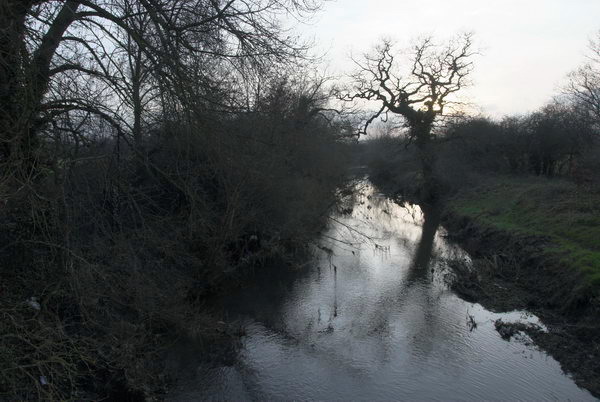
Culvert Road predates the Shaftestbury Estate and was important as an entrance to Poupart’s market garden on which that estate was built. It originally had a level crossing over the railway line here – four tracks leading from Clapham Junction and from the rail bridge over the Thames at Battersea to Wandsworth Road – but this was closed and a narrow footbridge reached by slopes on each side provided in 1880. This footbridge provided may vantage point for this picture.
Culvert Road continues to the north in a tunnel out of picture to the left under around 13 more tracks leading to Victoria or Waterloo. Over the railway viaduct you can see the blocks of the Doddington Estate.

The history of the Shaftesbury Park Estate, developed by the the Artizans, Labourers and General Dwelling Company between between 1873 and 1877 was roughly based on workers cities (cités ouvrières) built earlier in France.
Its development was overshadowed by one of the era’s largest scandals which resulted in the entire board of directors being replaced in 1877 and its secretary/manager William Swindlehurst and chairman Baxter being jailed for conspiracy and fraud, and another director fleeing the country. You can read more of the details on the Survey of London.

When the disgraced board of the Artizans, Labourers and General Dwelling Company was replaced in 1877 their architect, the self-taught Robert Austin was sacked. His more conventionally qualified assistant was also dismissed the following year to save money. But the work of the pair has stood the test of time with a remarkable overall unity about the estate, planned on a grid system, enlivened with some minor and varied decorative features.
Despite its board’s fraud, the estate was generally well-built and houses provided with good ventilation and an improved system of drainage, though this was a cause of arguments with the local authority which favoured traditional methods. There were also various community buildings, but the estate is best-known for not including a single pub, influenced by the temperance movement of the times. William Austin, usually thought of as the founder of the company, was a poor and illiterate navvy before taking ‘the pledge’ and becoming a successful drainage contractor and builder. He set up the company as largely a business enterprise, aimed at making an annual profit of 6% rather than for any great philanthropic intent. He was voted off the board before the scandal with The Survey of London quoting him as later explaining ‘I was too
honest for them’.

Broughton Street runs from the end of Eversleigh St east parallel to the railway lines before turning to cross Queenstown Rd and ending on Silverthorne Road. I think I was probably standing on the end of Eversleigh Street to photograph this long terrace on the north side which according to the Survey of London were built by partners Robert Lacy and James Flexman shortly after an agreement they made in 1867.
This block of over 20 virtually identical houses (that nearest the camera has a carriage entrance, as No 1 still does) is followed past a narrow entrance road leading to a tunnel to the London Stone Business Estate between railway lines by another long block much the same. The houses here along this side of the road are numbered consecutively from 1-52.
The houses in these terraces are quite substantial, three floors each with two main rooms and rather than their front doors opening directly onto the pavement all except the two end houses have vestigial front gardens.

I walked down Prairie Street to Queenstown Road taking a couple of pictures there before turning down Lavender Hill where I made another three, only this one on-line. I’d photographed this row of shops earlier but took this second picture showing the multiplicity of signs – a cinema poster with dinosaurs, Ice Cream, the two posts with signs for the off licence and vegetarian food. the shop fronts and a large JEANS up one of the curved ends of the houses. The area in front of the shops looks very different now.
This was the end of my walk on Friday 28th July but I returned to Clapham the following day to take more pictures – in a later post.
Flickr – Facebook – My London Diary – Hull Photos – Lea Valley – Paris
London’s Industrial Heritage – London Photos
All photographs on this page are copyright © Peter Marshall.
Contact me to buy prints or licence to reproduce.