Posts Tagged ‘tower blocks’

AxeDrax Wood Burning & Student Housing

Thursday, October 19th, 2023

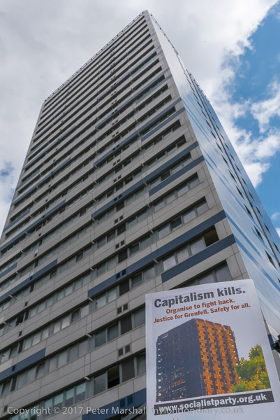
AxeDrax Wood Burning & Student Housing: Today, 19th October, is the International Day of Action Against Big Biomass (IDoA) calling for an end to climate-wrecking tree burning in power stations, and I hope to be attending a protest in London at Barclay’s Bank in Canary Wharf at noon calling for an end of the £billions in subsidies given to the world’s biggest tree burner, Drax, for burning trees and polluting communities. In 2016 I photographed a protest against Drax and another against providers of high cost (and high profit) housing for students.


AxeDrax protest against Biomass & Coal – Westminster

AxeDrax Wood Burning & Student Housing

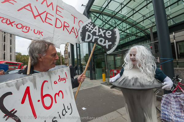
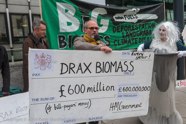
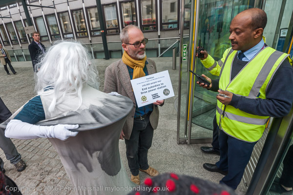
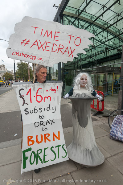
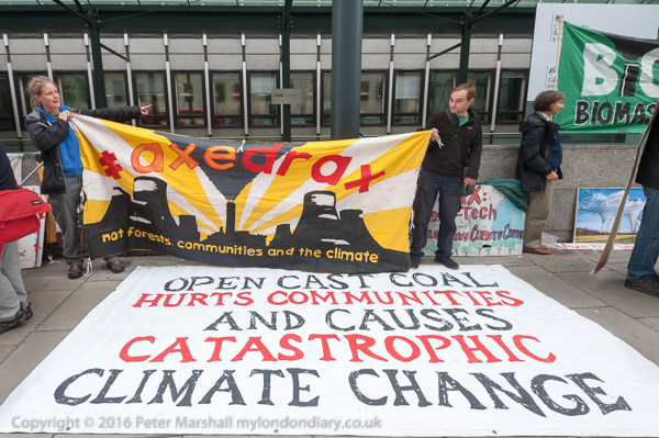
Back on Wednesday 19th Oct 2016 protesters came to the newly formed Dept of Business Energy and Industrial Strategy (BEIS) to urge the government to end the green subsidies to Drax as scientific research had make it clear that producing electricity from Biofuels is harmful to the climate, forests, biodiversity and people.

AxeDrax Wood Burning & Student Housing

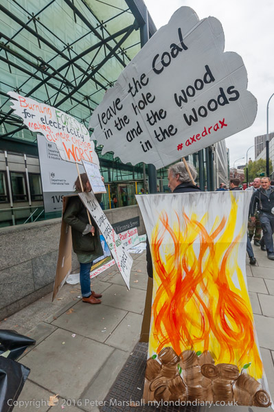
Biofuel Watch and London Biomassive, both part of the Axe Drax campaign had brought with them posters, banners and a cooling tower and were accompanied by the Draxosaurus dinosaur.

AxeDrax Wood Burning & Student Housing

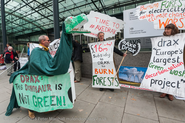
They demanded the government end the £600million a year subsidy Drax gets for its polluting activities and spend the money on measures such as building insulation to cut demand for electricity and to support the use of real low-carbon renewable electricity generation.

AxeDrax Wood Burning & Student Housing

Drax is an old and inefficient power generator, built for coal, still used in two of its six boilers in 2016, though in April 2023 they announced using coal had come to an end. The four boilers converted to wood pellet use waste 60% of the energy created in waste heat to the atmosphere and into the cooling water taken from and discharged into the nearby river Ouse. Without the huge annual subsidies it gets from our electricity bills it would not be viable. It should be closed as soon as possible and its workers trained for new green jobs which the huge subsidies currently spent on keeping this highly polluting facility open could provide.

As well as being generously awarded for adding excessive amounts of carbon and thus increasing global temperatures, Drax also creates large amounts of highly dangerous particulates, releasing over 400 tons a year into the environment in the UK. And Drax also creates environmental havoc in the areas which supply its wood – and until 2023, coal.

Much of the wood comes from destroying forests in the Southeast of the United States, and Drax also supplies wood to be burnt in other countries. It has mills to turn freshly cut trees into wood pellets in Louisiana, Alabama, Mississippi, and Arkansas. Planting the monoculture pine forests needed to supply these has been at the expense of the clear cut felling of older diverse forests and replacing them with sterile plantations with little undergrowth and wildlife.

Drax also buys wood pellets from the world’s largest pellet producer Enviva which cuts down large areas of highly diverse coastal hardwood forests in the US with an incredible loss of bio-diversity. Similar environment degradation and destruction of habitats is taking place in other countries around the world where Drax sources pellets. Their transportation to Drax also produces large amounts of carbon dioxide.

The pellet plants which produce wood largely from whole trees and complete felling of large forest areas to be burnt at Drax also generate huge amounts of air pollution both at Drax in Yorkshire and Drax at the US pellet plants were Drax has had to pay large fines for this. Most of these plants are in deprived, majority-Black communities.

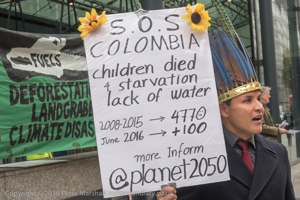
At the protest at the BEIS we heard a from a Colombian woman about the calamitous effect of open-cast coal-mining at the giant open-pit Cerrejón coal mine in La Guajira, northern Colombia. jointly owned by Anglo American, BHP Billiton and Glencore Xstrata.

Drax may now have ended burning coal and imports ended in 2020, but following the closure of UK mines all of the coal burnt there came from abroad, including from Colombia.

The Cerrejón mine is in Wayúu indigenous territory and the local people were not consulted when mining began there 30 years ago. Their land was simply seized and communities forcibly displaced in violation of their constitutional land rights and there was no proper compensation. Pollution and dust from the coal mine continues to contaminate the air and water supplies badly affecting traditional lifestyles; soil pollution leads to failed crops, and fishing areas have been contaminated.

Drax also had a carbon capture and storage project for its biomass plants, but this is only based on very limited trials and seems highly unlikely to ever have a significant effect, not least because the necessary infrastructure for the removal and storage of any carbon dioxide captured seems unlikely ever to be available. And by the time both the removal and disposal could possibly be implemented on any scale there will be absolutely no economic justification for retaining expensive sources of power such as wood burning rather than very much cheaper renewable generation.

AxeDrax protest against Biomass & Coal


Student Rent Strike protest – Holborn

I went on from the BEIS protest to Russell Square where students were meeting to discuss student housing. Once halls of residence were largely an at-cost service provided by universities, but have now become big business for private developers.

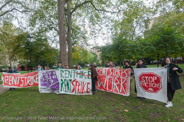
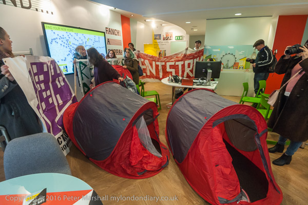
After some speeches they marched behind the #RENTSTRIKE banner to briefly occupy the nearby office of Unite Students, a FTSE 250 company housing around 50,000 students in the UK.

The event was a part of a nationwide series of protests taking place as investors and developers were discussing the rich profits to be made from students at the MIPIM conference, the world’s largest real estate market event in Cannes.

Many of the large new blocks of student housing have flats with rents larger than the entire student loan, higher than all but students from very wealthy families can afford, and are largely for letting to rich overseas students studying here.

More pictures at Student Rent Strike protest.


Homerton to Hackney Wick

Monday, May 9th, 2022

Homerton to Hackney Wick – This walk I made in October 1988 continues from where my previous post Morning Lane, Paint, Handbags and Printers ended.

Homerton High St, Homerton, Hackney, 1988 88-10d-01-Edit_2400
Homerton High St, Homerton, Hackney, 1988 88-10d-01

Immediately east of Mackintosh Lane on the south side of Homerton High St at No 178-84 was an unusual arched brick wall, which attracted my attention. Thistle House at 178-82 was a hostel with 33 rooms in multiple occupation. Part of the wall shown in this picture has now been demolished to allow storage of large rubbish bins. The wall goes in front of two distinct houses, both of which have one circular window – but in the joined house it is above the second floor window.

Barnabas Rd, Homerton, Hackney, 1988 88-10d-63-Edit_2400
Barnabas Rd, Homerton, Hackney, 1988 88-10d-63


Barnabas Rd runs south from Homerton High Street past Homerton Station. In 1988 the premises of printers Alan Moor & Co at No 24 was up for auction. It is still there and remains a handsome villa – my photograph doesn’t really do it justice. I suspect it dates from around 1860 when Barnabas Road was called Church Road, (it was renamed in 1936) but can find no details. The rather ugly porch has I think been extended since 1988.

The Immaculate Heart of Mary & St Dominic, RC, Church, Kenworthy Rd, Homerton, Hackney, 1988 88-10d-64-Edit_2400
The Immaculate Heart of Mary & St Dominic, RC, Church, Kenworthy Rd, Homerton, Hackney, 1988 88-10d-64

Originally called the The Church of the Immaculate Heart and St. Dominic it was designed by C A Buckler and built on what was until 1939 Sidney Rd two years after a mission was founded here in 1873. The church, completed in 1883, was badly damaged by bombing and fire in 1941 and was rebuilt in 1955-57. My picture shows it with shops on the corner of Wick Rd, where there is still an Indian takeaway.

Hackney Hospital, Homerton High St, Kenworthy Rd, Homerton, Hackney, 1988 88-10d-65-Edit_2400
Hackney Hospital, Homerton High St, Kenworthy Rd, Homerton, Hackney, 1988 88-10d-65

I went up Kenworthy Road back to Homerton High St, stopping on the corner of Ward Lane to make this picture of the East Wing of Hackney hospital, which I think is Pavilion B, built in 1880-82, designed by William Finch, a typical design for the time with long airy ‘Nightingale Wards’ and towers at the corner containing sanitary facilities. (I stayed on a similar ward in a south London hospital in 2003 just before it was demolished – and collapsed in the disconnected sanitary area after an operation, fortunately in reach of the red emergency cord which I came around sufficiently to pull and bring medical staff running to my aid.) Although Hackney Hospital closed in 1995, parts are still in use for mental health services and a notice calls this the John Howard Centre, which provides low and medium secure mental health services for North East London.

Shops, Homerton High St, Homerton, Hackney, 1988 88-10d-66-Edit_2400
Shops, Homerton High St, Homerton, Hackney, 1988 88-10d-66

These buildings are still there at 201-205 Homerton High Street, though in different hands. Back in 1988 a Bookmakers next to a Turf Accountant (a rather upmarket term for the same thing) seemed excessive, while F A MURRELLS business was completely hidden by shutters. It seemed to be some kind of miniature business, the whold width of the property perhaps around 7 ft with a tiny door only suitable for a slim child in the shutters. Whatever was going on inside – or rather had once gone on inside – obviously involved something of some value, worth protecting with an AFA Burglar Alarm, perhaps a jewellers or pawnbrokers? But this tiny shop had obviously been fairly recently sold – and now appears to be a residential property.

The Adam & Eve, pub, Homerton High St, Homerton, Hackney, 1988 88-10d-51-Edit_2400
The Adam & Eve, pub, Homerton High St, Homerton, Hackney, 1988 88-10d-51

There has been an Adam & Eve tavern in Homerton High Street since at least 1735, but its fine frontage is dated from 1915 and was recently restored. Its cream terracotta front includes a large relief showing very chastely the couple before the fall but underneath an apple tree. In 1988 it was a Taylor Walker pub (though Taylor Walker had been taken over and closed in 1960), now it is described as a gastro-pub, with fresh food from the farm daily and offering “CURING – MICROBREWERY – ALLOTMENT”. The Taylor Walker pub sign was rather better and had above the field gun that came from the Clerkenwell Cannon brewery they took over in 1929.

East Cross Route, Hackney Wick, Hackney, Tower Hamlets, 1988 88-10d-55-Edit_2400
East Cross Route, Hackney Wick, Hackney, Tower Hamlets, 1988 88-10d-55

The East Cross Route was a part of the disastrous Ringways plan for concentric motorway rings around London. This was one of two major parts of the of the innermost Ringway 1 which actually got built between 1967 and 1973. The cost and environmental devastation caused by the building of the Westway in North Kensington led to a huge backlash which led to the cancellation of the remaining parts of the scheme.

The East Cross Route was less controversial, partly because it was in East London and most politicians and others didn’t much care about what happened there, but also because it largely replaced an existing rail line which had long separated the communities on each side. For much of its length there was in any case little between the road and the natural boundary of the River Lea and the Lea Navigation.

There were relatively few roads which ran across the area, and the links across the new road were maintained with both Wick Lane and Wick Road still leading to Hackney Wick. Olf Ford Road no longer led to Old Ford, except by a footbridge, but for vehicles the detour was relatively short. The bridge I was on when I made this picture carries a footpath across Victoria Park from Cadogan Terrace to Rothbury Road in Hackney Wick. The Trowbridge Estate built in 1965-9 had 7 rather striking 21-storey tower blocks. Demolition of these had begun with Northaird Poiont in 1985 and all had gone by 1996.

The final post in this series, appearing shortly, will include my pictures from Hackney Wick where my walk ended.


Fire Risk Tower Blocks

Thursday, August 12th, 2021

Newham 12 August 2017

Ferrier Point, Canning Town

In the now over four years since the disastrous Grenfell Tower fire in June 2017 there has been little change and no reckoning, with a tediously slow inquiry taking place that began by shifting blame unfairly onto the firefighters but is at last making clear some of the deliberate failures by local government, manufacturers and installers of the fatal cladding and others with a complete disregard for the safety of those living in the tower.

Cladding was not of course the only issue, and there were many other failings that led to the terrible loss of life. Most basic was the attitude of governments of both parties towards health and safety issues, describing essential safety regulations as “red tape” and dismantling what were essential checks to increase the profitability of builders and developers and reduce the liabilities of building owners. It was a system that needed reforming and strengthening, perhaps learning from practice in other countries to provide effective control and not abandoning to commercial whim.

Most of what has emerged in the inquiry only reinforces what was already made clear from informed reports – such as that by Architects for Social Housing – within weeks of the fire, adding truly shameful detail to the broader outline. It surely should have come out in courts within months of the fire and some of those responsible might well be behind bars and companies charged with massive fines, and the main point of the inquiry seems to be to prevent the course of justice.

A resident of Tanner Point speaking

Local authorities and building owners have been forced to inspect their high-rise properties, and the government has provided at lest some of the money it promised to replace unsafe cladding in the public sector. But little has been done for those living in private blocks who are still living in fear and now pay increased charges for extra fire safety provisions. A parliamentary briefing paper estimates the total cost of replacement of unsafe cladding at around £15m, and so far government has come up with a third of that. Government policy has changed from the initial promise to fund “remediation of historical safety defects, to a suggestion that leaseholders should be protected from unaffordable costs” and even the provision for a low interest scheme to ensure they would not pay more than £50 a month has failed to materialise despite the promise in the current Building Safety Bill.

In August 2017, a number of tower blocks in the London borough of Newham were found to have unsafe cladding. Housing activists Focus E15 Mothers led a demonstration putting pressure on the council to act urgently to make the blocks safe. The council came to a decision the following month to remove the cladding though work to do so only began in April 2018.

The march began at Ferrier Point in Canning Town, with other groups including East End Sisters Uncut, Movement for Justice, the Socialist Party, the Revolutionary Communist Party, One Housing campaigners and Whitechapel Anarchists joining Focus E15 and some tower block residents.

From there they marched to Tanner Point in Plaistow North for a longer rally outside, including some speeches from tower residents. Then came another long march to Stratford and the Carpenters Estate.

The Carpenters Estate was a popular estate, close to Stratford station and the town centre, and was viewed by the council as a prime opportunity for highly profitable redevelopment schemes, wanting to demolish the estate which is well-planned and in good condition. Focus E15 led opposition that in 2013 ended plans for UCL to set up a new campus here and have constantly urged the council to bring back people to the estate where despite a critical housing shortage in the borough, 400 good homes had been kept empty for over 10 years. The march ended with a ‘hands around the Carpenters Estate’ solidarity event against decanting, demolition and social cleansing.

More pictures at Fire Risk Tower Blocks.


All photographs on this and my other sites, unless otherwise stated, are taken by and copyright of Peter Marshall, and are available for reproduction or can be bought as prints.


Maida Hill & Elgin, 1988

Wednesday, May 26th, 2021

Prince of Wales Cinema, Bingo Hall, 331 Harrow Rd,  Westbourne Park, Westminster, 1988  88-3a-12-positive_2400
Prince of Wales Cinema, Bingo Hall, 331 Harrow Rd, Westbourne Green, Westminster, 1988

Although most Londoners will have heard of Maida Vale, few will have heard of Maida Hill, and those that have will probably – like me – be very unsure of where it changes to Westbourne Green or West Kilburn. Many of the old London district names have more or less disappeared, and estate agents take remarkable liberties with the boundaries of areas they feel are currently more upmarket.

Harrow Rd,  Westbourne Park, Westminster, 1988  88-3a-13-positive_2400
Harrow Rd, Westbourne Green, Westminster, 1988

Part of the reason for this is increased mobililty, particularly in those areas of London were many live in private rented accomodation, often with short-term leases or where for various reasons tenants often move very frequently. Most of the inner London boroughs were developed by before the First World War, and grew up first around the old named village centres – and later around the railway stations, underground stations and tram routes.

Shops, Harrow Rd, Maida Hill, Westminster, 1988 88-3a-43-positive_2400
Shops, Harrow Rd, Maida Hill, Westminster, 1988

People know Maida Vale mainly because it has an Underground Station – something Maida Hill lacks. And most – including myself – tend to forget that the area is Westbourne Green and call it after its station, Westbourne Park. The ease of travel – by rail, bus and bike, and later by car loosened the links of people to their native villages and of course many more came into the new houses in London from other parts of the country, and later the world.

Walterton Rd, Elgin Ave, Maida Hill, Westminster, 1988 88-3b-66-positive_2400
Walterton Rd, Elgin Ave, Maida Hill, Westminster, 1988

I grew up in the town on the edge of London where my father had been born in 1899. He’d worked elsewhere – including a couple of years when the army and air force took him to France and Germany, but had also commuted to various jobs in towns and areas around, including Kew, Guildford and Harrow thanks to buses or a motorbike. But back in the 1950s when I walked down the main road with him he would still be greeting almost everyone we met by name.

Walterton Rd, Elgin Ave, Maida Hill, Westminster, 1988 88-3a-16-positive_2400
Walterton Rd, Elgin Ave, Maida Hill, Westminster, 1988

Captioning my photographs, even those where I know exactly where they were taken, I often have difficulty in deciding the name of the district in which they were taken. Sometimes I come back to one later and change my mind. Deciding which London Borough they are in is generally easier – the borough boundaries are marked by lines on maps, although sometimes, particularly where the boundary runs down the centre of a road I give both if I’m unsure what side of the road it is on. A minor confusion is that some London boroughs share a name with a district which is a part of them. I could write things like Camden, Camden, but it seems redundant to repeat it.

The Elgin Estate is possibly in Paddington, North Paddington or in Maida Hill, though the area is also sometimes simply referred to by the major road it is close to, the Harrow Road. When I put these pictures on-line I chose Maida Hill, simply because this was printed closer on the street map I was using.

Elgin Estate, Elgin Ave, Harrow Rd, Maida Hill, Westminster, 1988 88-3a-21-positive_2400
Elgin Estate, Elgin Ave, Harrow Rd, Maida Hill, Westminster, 1988

The triangle between Harrow Road, Elgin Avenue, and Chippenham Road contained some of the areas worst housing and the Greater London Council demolished these and built 300 maisonettes and flats in what was originally called the Walterton Road estate but later renamed the Elgin Estate. Started in 1966, the first tenants moved in in 1968.

It included two 22-storey tower blocks, Chantry Point and Hermes Point. A survey in 1983 found them and the rest of the estate in very poor condition and the GLC began a full-scale process of repairs. Unfortunately once work began it was brought to a halt when dangerous asbestos was found in the two tower blocks, which by then had been transferred to Westminster Council, though the GLC was still responsible for major works.

Elgin Estate, Elgin Ave, Harrow Rd, Maida Hill, Westminster, 1988 88-3a-11-positive_2400
Elgin Estate, Elgin Ave, Harrow Rd, Maida Hill, Westminster, 1988

Westminster stopped letting the blocks to new tenants though some lettings continued on short-term licences and other flats were squatted and the properties rapidly deteriorated. When the GLC was abolished in 1986 full responsibility passed to Westminster Council who secretly decided to sell the whole estate to private developers who intended to demolish the lot and rebuild at twice the density with one of the towers becoming a hotel.

Elgin Estate, Elgin Ave, Harrow Rd, Maida Hill, Westminster, 1988 88-3a-24-positive_2400
Elgin Estate, Elgin Ave, Harrow Rd, Maida Hill, Westminster, 1988

When the plans leaked, residents formed an action group demanding the council drop the plans and setting up their own proposals to save the homes. The council wanted to get rid of social tenants and replace them by wealthier home owners, to increase the Tory vote in the area, part of a process of exporting Westminster homeless families to boroughs on the edge of London and outside to places such as Staines. The Elgin estate – despite being known as having an asbestos health risk – was also used as a dumping ground for council tenants who were moved out of marginal wards. It was a policy that in 1997 was found by the High Court to be unlawful. The council appealed and won, but then lost in the House of Lords in 2001 when Lady Porter, leader of the council from 1983 to 1991 was ordered to pay a surcharge (including interest) of £43.3 million. She moved most of her money to Israel and to other family members and pleaded poverty, but eventually settled with a payment of £12.3 millioon.

Elgin Estate, Elgin Ave, Harrow Rd, Maida Hill, Westminster, 1988 88-3a-44-positive_2400
Elgin Estate, Elgin Ave, Harrow Rd, Maida Hill, Westminster, 1988

By 1988 when I made these pictures around a third of properties on the estate were empty with doors and windows blocked by steel sheets to keep out squatters who already occupied many of the flats in the two towers. But the 1988 Housing Act gave the remaining residents the chance to form a housing association, Walterton and Elgin Community Homes, which was then able to hold a ballot and acquire the homes from Westminster Council. In March 1989 WECH became the first ‘Tenants’ Choice’ landlord to be approved by the Housing Corporation, and despite various dirty tricks by the council, in 1991 was not only given the properties free of charge, but also awarded the maximum possible amount from the council of £77.5 million to cover the cost of repair (though this was only around a half of what was thought to be needed.

A vote by residents was 72% in favour of the transfer to WECH which was made in April 1992. Redevelopment of the area was carried out with extensive consultation with them, and involved an expensive demolition of the two towers in 1994, replaced by low rise housing.


All photographs on this and my other sites, unless otherwise stated, are taken by and copyright of Peter Marshall, and are available for reproduction or can be bought as prints.


Towards Hackney Wick 1982

Wednesday, December 30th, 2020

I continue my virtual walk downriver towards Hackney Wick.

Clapton Park Estate, Clapton Park,  Hackney, 1982 32k-64_2400

Past the Clapton Park Estate: Norbury Court, Bakewell Court, Ambergate Court and Sudbury Court at 172 Daubeney Road, each 20 stories with 114 flats, approved by Hackney Council in 1968. Three were demolished by explosions in 1993-5 but Sudbury Court was sold to a private developer who gave it a relatively minor make-over and renamed it Landmark Heights.

Clapton Park Estate, Clapton Park, Hackney, 1982 32k-53p_2400

Somewhere I passed a canal-side factory –

Hackney Wick, Tower Hamlets, 1983 36n-46_2400

as well as the wide expanse of Hackney Marshes, with what must surely be more football pitches and anyone needs

Hackney Marsh, Hackney Wick, Hackney, 1982 32z-62_2400

as well as some wilder areas where the hogweed grows

Hackney Marsh, Hackney Wick, Hackney, 1982 32u-13_2400

and was ambushed by a group of children

Hackney Wick, Hackney, 1982 32k-51_2400

who demanded I take their pictures.

Hackney Wick, Hackney, 1982 32k-42_2400

Clost to Eastway I came across a travellers site

Travellers site,  Eastway, Stratford, Newham, 1983  36o-12_2400

close to the River Lea, here looking a very serious river away from the navigation.

River Lea, Eastway, Stratford, Newham, 1983  36o-13 (2)_2400

My walk continued but in a less linear fashion wandering around Hackney Wick – in the next episode. You can see all the pictures and more in my album River Lea – Lea Navigation 1981-1992.


All photographs on this and my other sites, unless otherwise stated, are taken by and copyright of Peter Marshall, and are available for reproduction or can be bought as prints.