Cycling Around the Isle of Dogs: Tuesday June 24th 2014 was a nice Summer day in London. Not too hot, with a maximum in the low twenties, and with a blue sky tempered by some nice clouds and just a few light showers to cool me down. For me it was an ideal day for a bike ride and also for making some panoramic images.
It was a while since I’d been to the Isle of Dogs, and there had been quite a few changes around there in recent years, so after an early lunch I put my folding bike on the train and made my way to Limehouse.
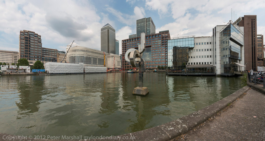
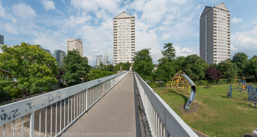
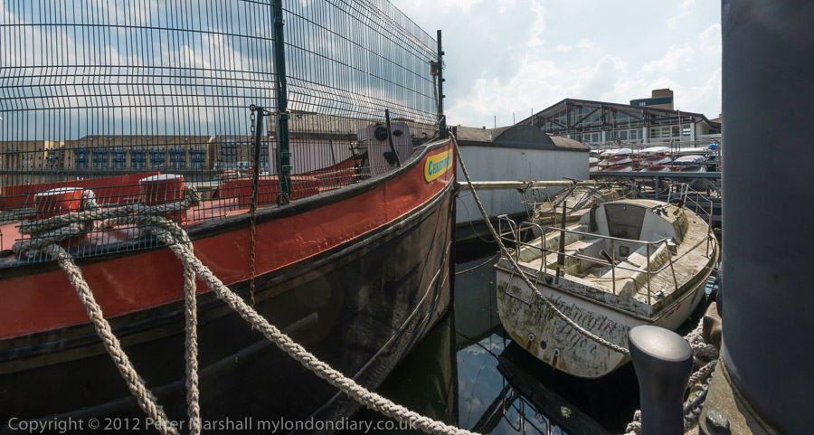
It wasn’t really a bike ride, more just using the bike to carry me and my camera around the area, stopping on my way to make well over two hundred panoramic images in the roughly two and a half hours it took me to get to Island Gardens, opposite Greenwich for the train home. Later I worked on these images, selecting around 90 to put on-line – a higher than usual proportion. But I do rather more thinking about panoramic images and they require rather more care, particularly to get the camera absolutely level to keep the horizon straight.
I posted them in two groups, Limehouse pans and Millwall – Isle of Dogs pans. All the images were converted using the PT Gui software implementation of the Vedutismo perspective (also called Panini) made popular by Canaletto and other Italian cityscape painters in the 18th century which allows a more realistic representation of extreme angles of view – something like 147 degrees horizontally in these images. These would be impossibly stretched towards the edges in a normal rectilinear view, which only works up to around 90 degrees.
You can see any of these images larger on the links given to My London Diary at the end of this post, or by right-clicking on any of them and selecting to view them. Rather than write more about the ride here, I’ll quote from one of the posts there:
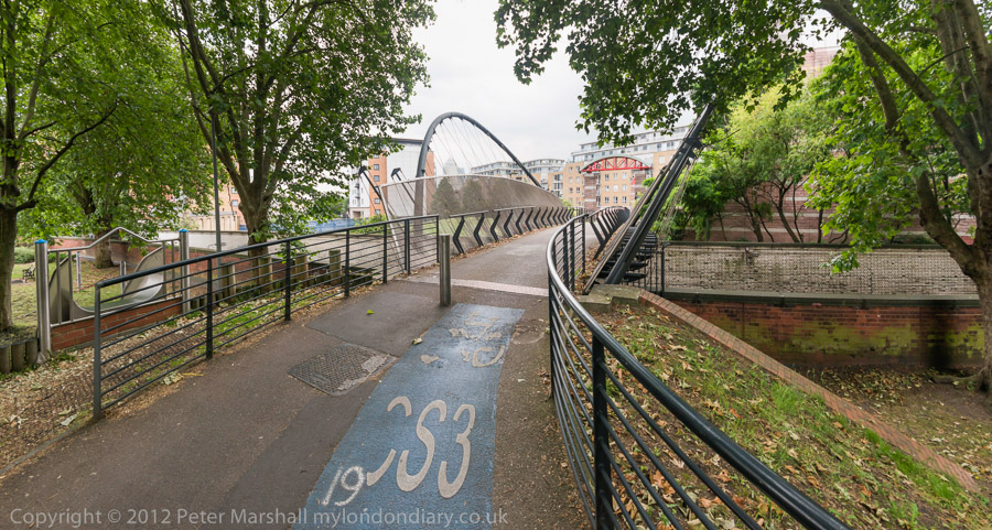
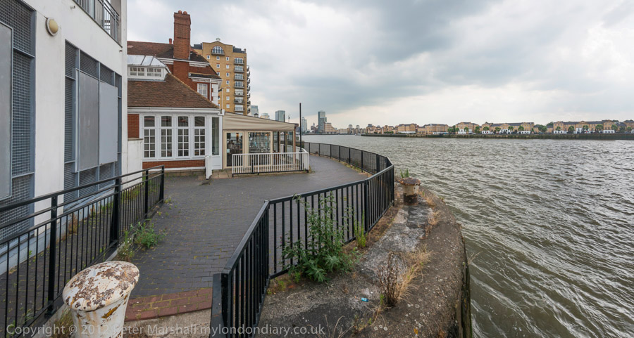
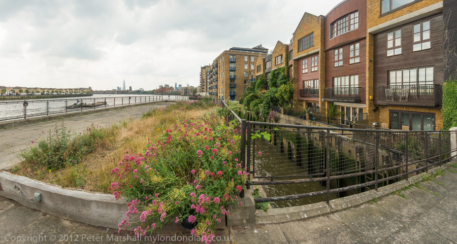
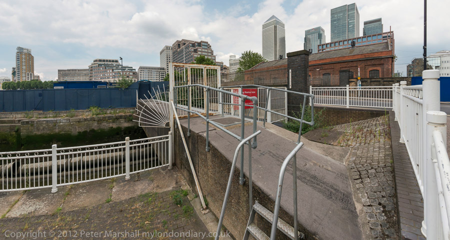
When I first walked these streets there was virtually no access to the riverside, with wharf after wharf between Westferry Rd and the river until you came to the park (Sir John McDougall Gardens.) A footbridge led from the Barkantine estate – built to replace a heavily bombed area of densely-packed small houses. South of this you again walked along the busy street until there were a few empty wharves around the south of the Isle of Dogs.
Now you can walk mainly along the riverside, with only one working area blocking the path. But there are several other places where you have to divert, including one wall dividing social housing from its wealthy neighbours. There was also a temporary diversion in one area, though it wasn’t clear why.
Further on are fine views across the river to Greenwich, along with further diversions from the riverside, where several earlier developments did not include riverside walks.
The Thames is too wide here for a panorama to work well without some foreground interest, or cropped to a very narrow strip. At the end of the ride, I did make a few pictures from Island Gardens across the river with a rather longer lens. These are in a separate post, also linked below.
No 326, with two doors above each other with steps to the upper door with a balustrade. Many of the houses along here date from the first development along the road and are good examples of early-mid 19th century houses and most have some intresting features but are perhaps not distinctive enough to deserve listing.
The house now looks much the same as when I photographed it. I suspect this unusual arrangement with steps up to the front door was how this house was built. While many houses from the period have basement flats, this appears to have been built with its ground floor rather higher, perhaps becuase of the risk of flooding from the River Effra. But if so, why was a similar approach not used for neighbouring houses?
J & P Motors, Thornton St, Stockwell, Lambeth, 1989 89-5d-63
I walked a little back up Brixton Road to Thornton Street, though too much has changed for me to positively identify the exact location of J & P Motors on this fairly short L-shaped street. I think it was probably on the north side of the bottom of the L behind what is now the worker’s co-operative, Brixton Cycles.
There was a splendid utilitarian simplicity of this building which appealed to me, and which I enhanced with its symmetrical gates and No parking signs.
Back on Brixton Road, Evereds Bathrooms had its showroom in two shops at 308-10 Brixton Rd. The buildings here are still standing but no longer in use as a shop. For some years since 2011 the Victorian shopfront built as a house agents in 1879 has been in use as an art gallery, SHARP Gallery (Social, Hope and Recovery Project) which has shown the work of over 120 artists, many of whom use mental health services and is supported by the South London and Maudsley NHS Trust. Both the early nineteent century house and these shops are Grade II listed, along with 312.
Both buildings at 304 and 306 Brixton Road have survived, but in 2013 planning permission was granted for changes to the Eagle Printing Works, and the fine semi-circular panel including the building date of 1864 and its wrought-iron decoration was removed – a piece of vandalism that should never have been approved.
Apparently the printing works a few years later became a sub district Post, Money Order and Telegraph Office, and it was from here that Sherlock Holmes sent his first telegram.
I turned off the Brixton Road where I had spent some time wandering back and forth and struck off to the east along Loughborough Road. The first picture I took was of the Loughborough Hotel, described in more detail on a previous walk, a well known music venue, closed in 2008 and has been converted into flats, with a café gallery on the ground floor.
From Fiveways I continued along Lilford Road, again stopping to re-take the impressive porch on its corner with Minett Road, also featured in a previous post. I chose a very similar viewpoint but the lighting was quite different as it had been overcast for the earlier image.
I can’t remember why I made the detour, though possibly it was just the sheer pleasure of seeing an area with so many fine buildings again. Or it could have been to find a pleasant place to sit and eat my lunch, as I walked as far as Myatts Fields before returning to Loughborough Rd.
On Loughborough Road I was in a very different London, the Loughborough Estate, redeveloped after much of the area was devastated by wartime bombing. The first stages of the rebuild were in five-storey red brick blocks typical of 1930s LCC estates of that era, solid and with decent sized rooms but uninspiring visually. There height was kept to five floors as they had no lifts.
From 1954-7 more of the estate was developed with a mix of high and low-rise modern buildings designed by the LCC Architects Department which included nine eleven-storey slab blocks which became a model for later LCC estates. They even gained approval from John Betjeman who Layers of London quotes as writing “When one compares their open-ness, lightness, grass and trees, and carefully related changes of scale from tall blocks to small blocks, with the prison-like courts of artisans’ dwellings of earlier ages, one realises some things are better than they were… Maybe it has no place for someone like me, but it gives one hope for modern architecture.”
Not everyone shared Betjeman’s enthusiasm, and by the time I made these pictures the area had gained a reputation for crime, one of a number of estates in London about which some people expressed shock that I was walking around taking pictures. More about my walk in a later post.
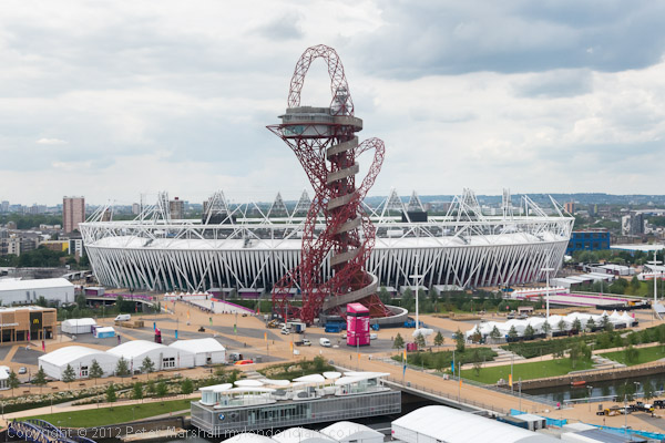
2012 Olympics – Lund Point Holdup By BBC: Eleven years ago on Saturday 21st July much of the nation was eagerly awaiting the start of the 2021 London Olympics. I wasn’t, though I was at least starting to think it wouldn’t be long before it was all over, but we still had it all to put up with. All the pictures in this post were taken at events around the area that day.
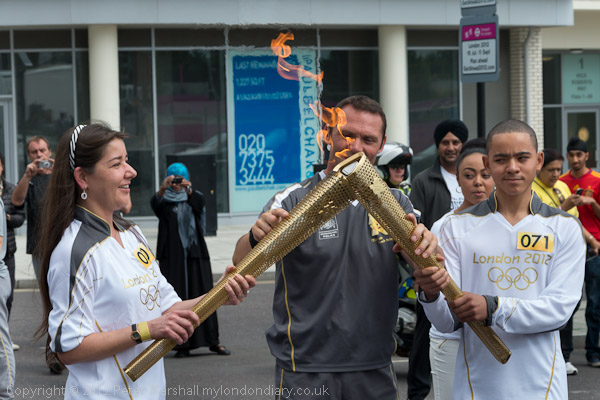
Waiting for the Olympic flame – Stratford High St
Many still regard it as having been a great national event, bringing people together, but I still find it hard to have many positive thoughts. Like another major event, most of the promises we were made about its legacy have turned out to be false. Many were clearly lies from the start, and a huge attempt was clearly made to mislead the public, with our newspapers and broadcast media playing a major and continuing role.
On the streets of east London there were many critics and sceptics from the start, many like me who were surprised and alarmed when the bid was won in 2005. Most of their worse fears have since come to pass and the local area has seen little gain.
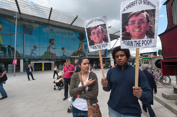
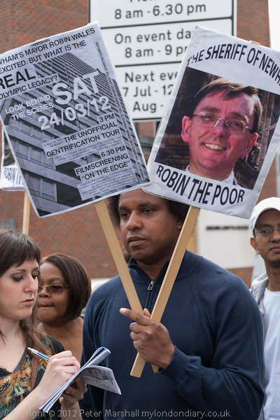
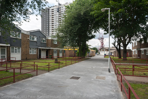
Newham remains an area with huge housing problems, and it was some of those that took me there on Saturday 21st July 2012, specifically over the council’s terrible treatment of the Carpenters Estate, a once popular council estate adjoining Stratford Station.
It’s location made it a valuable prey for developers and Newham’s elected Labour Mayor, Sir Robin Wales had clearly thought the site was being wasted on its social housing tenants and had begun running it down and ‘decanting’ residents back in 2004. But schemes to sell it off, including one as a new campus for University College London (UCL) were eventually stopped by protests from residents, UCL students and staff and Stratford’s dynamic housing activists, Focus E15.
Good solid 1960s housing on a pedestrianised street . A popular estate on which many bought houses
Focus E15 had begun when Newham Council decided to shut down a hostel in central Stratford for single mothers and their children, offering only to move them out of Stratford to distant towns and cities across the UK into poor quality private rented accomodation with no security of tenure and higher rents, some hundreds of miles away from family, friends, nurseries and other support they had in Newham. Robin Wales infamously told them “if you can’t afford to live in Newham, then you can’t afford to live in Newham”.
A woman still living on the Carpenters estate
The Focus E15 mothers stood together and fought – and largely won, getting rehoused in the local area. But they decided to continue their fight for others in housing need, particularly in Newham. There story became national news and they continue with weekly stalls on Newham Broadway and a shop not far away.
Lund Point – advertising added for Olympics without consultation
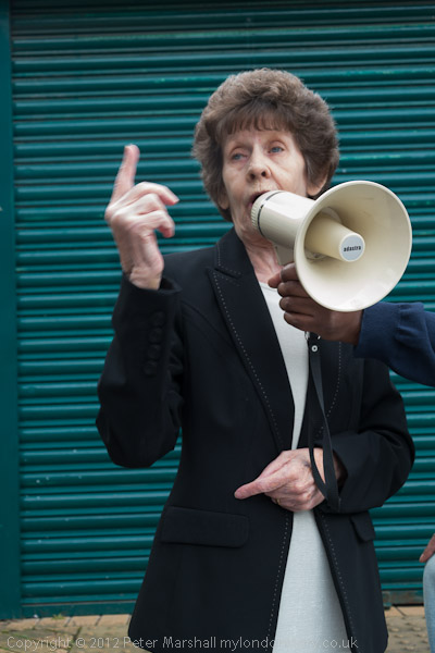
Carpenters Estate residents were shocked when the council in 2011, upset that residents wanted to remain on the estate, decided to fix the elections to the Carpenters Tenant Management Organisation (TMO) by barring freeholders on the estate from standing and simply losing five of the six nominations from leaseholders. Security staff prevented freeholders who had received invitations to the meeting from attending, effectively allowing Newham council to take over the TMO and end any real participation by residents over the esatate’s future.
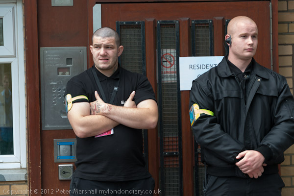
BBC employed security – the sign says Residents Only
Residents formed Carpenters Against Regeneration Plans (CARP) to challenge the decisions made by the TMO and to get it to fulfil its duties to all residents of the estate, and to fight for the future of the residents and for a sustainable community. In particular freeholders were appalled at the low valuations put on their properties by the TMO commissioned valuation service, with compensation for compulsory purchase often appearing to be only around half of market values for similar propeties in the area.
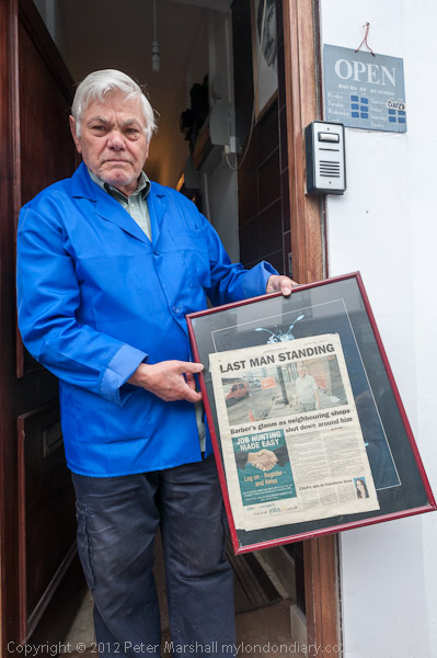
This Barber – the last man standing on Stratford High St
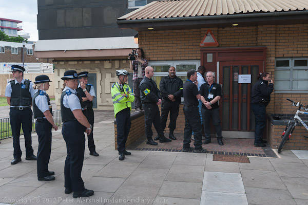
CARP had arranged a number of tours around the estate, and I met with them at Sratford Station, having on my way taken a few pictures of the Olympic Torch Relay which had passed along Stratford High Street earlier in the day, though only watched there by a small handful of people. There were more on a footbridge built for the Olympics across this busy main road, which would have been a small but useful Olympic legacy, but was to be demolished shortly after.
Police had come to back up BBC security and refuse us entrance
Our tour from the station led by Tawanda Nyabango who lived for many years in one of the tower blocks and several other residents including CARP vice-chairman Joe Alexander talked to us on a lengthy tour of the estate and the nearby Waterworks River, one of several waterways through the Olympic site.
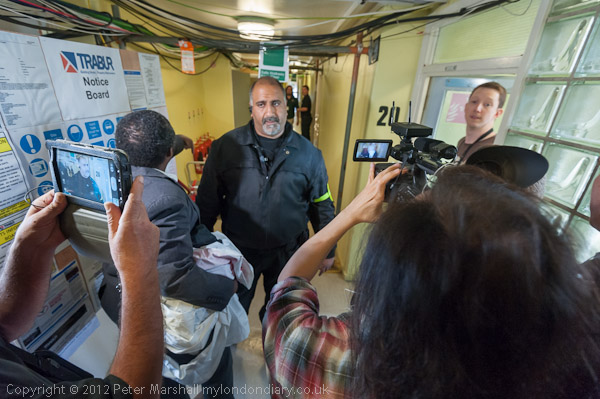
After we were allowed in BBC security try to stop us leaving the lift
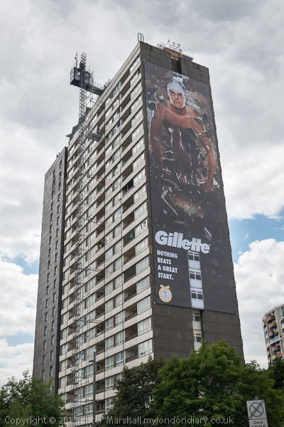
We then tried to visit two more residents living in flats in one of the three tower blocks on the estate, Lund Point. The BBC were setting up in the top five floors of the block for their Olympic coverage, and we were prevented from entering the block by BBC security staff who then brought in police to support them.
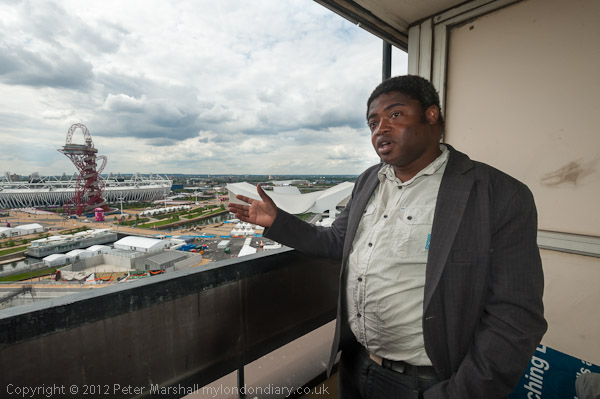
But finally we made it to a flat on the 20th floor
We argued that we had an invitation from the residents, but were still refused entry, until after and hour and a half waiting finally the police officers present received orders that they had no right to refuse our entry and we were finally allowed in.
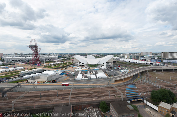
The Olympic site from Lund Point
I was able then both to meet the residents and photograph the Olympic site from their windows. The residents of the block have complained strongly about the way the BBC have taken over parts of their building and apparently our holdup was simply one of many incidents. I took rather more pictures including some panoramic views – at Olympic Views though my time here was very limited.
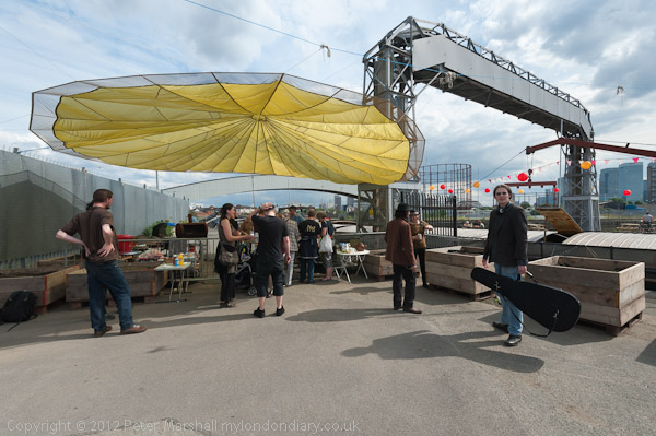
I had intended to finish my day after the Carpenters Estate tour with a visit to the Open Day taking place at Cody Dock on Bow Creek, and I hurried there from Stratford. But because of the holdup at Lund Point, the events there had ended by the time I arrived, and I took a few pictures and left for home.
At Cody Dock
Robin Wales is no longer Mayor, eventually being forced out despite his attempts to manipulate votes to remain in office. Under the replacement Labour Mayor there are new plans for the Carpenters Estate though Focus E15 are still campaigning for the repair, refurbishment and repopulation of the estate with long-term council tenants.
Much more about all these events on My London Diary:
On the Road to Brixton is the second post on my walk in Kennington and Brixton on Sunday 6th May 1889. The posts began with Hanover, Belgrave, Chapel, Shops, Taxis.
This remarkable Grade II* listed building in a composite of Art Nouveau and Byzantine Revival style was designed by Arthur Beresford Pite who was the brother-in-law of the then vicar, Rev William Mowll, whose name is on the adjoining street. It was completed in 1907, though the design dates from the 1890s and the foundation stone was laid in 1898 and the building consecrated in 1902.
It remains in use as an Anglican Church. Some describe it as an architectural monstrosity, but although I think it has a rather split personality it has an overwhelming impact.
The church was built on the site of an earlier chapel, Holland Chapel, built as an Independent Chapel around 1823 and sold to the Church of England around 1835 and renamed Christ Church. This was a simpler building with a central bell turret but of some size, seating around a thousand and was demolished in 1899, with worship continuing in a hall behind while the new church was being built.
The Holland Chapel had no graveyard and Christ Church was at first only a chapel in the parish of St Mark’s Kennington where burials took place. Before 1825 all this area was in the parish of St Mary Lambeth, now the Garden Museum next to Lambeth Palace. Christ Church became a parish church in 1856.
The building is often open to the public over the centre of the day and the stained glass is said to be spectacular. The interior (which I’ve not photographed) has more of an Art Nouveau feel than the exterior. The building has been considerably altered since 1907. It was built to seat 1,200.
You can just about see one of the many unusual features of the church at the extreme left of the picture, where there is a bell-shaped roof over an external pulpit, added to the building in 1907 at the insistence of the vicar.
This terrace is opposite Christ Church and runs from 91 to 115 and was built at Bowhill Terrace. Some of the houses are stuccoed like these with others left as plain brick. I chose this pair partly for the bark of the tree at left, but also because of the different treatment of the two doors at the top of the steps leading up to both. I think the steps and their railings are probably a modern replacement.
Many of the houses along Brixton Road were in poor condition in the 1970s and were refurbished by the Greater London Council, mostly becoming social housing
Brixton Road was a Roman Road leading down to the south coast and was at one time known as ‘The way to Brighthelmstone’. Among other former names was Brixton Causeway, an embanked roadway running along the west bank of the ,. That it was also known as ‘The Washway’ perhaps suggests that it was sometime flooded by the river. The river was lowered and built over in 1880, becoming a sewer below the street and the earth extracted used to provide banking at the nearby cricket ground, The Oval.
Modern development beside the road only gathered pace after the building of Vauxhall Bridge in 1816 and acts of parliament for roads south from that meeting with Brixton Road at the Oval.
“Between 1820 and 1824 the whole of the Manor was let to Henry Richard Vassall, third Baron Holland” and developed piecemeal by “builders and speculators” under building leases as brick houses “of at least the third rate“. According to the Survey of London, “This policy of piecemeal letting, especially in the Brixton Road, resulted in unrelated groups of villas and terrace houses which, in spite of the charm of individual members, gave to the whole an untidy and haphazard appearance.” For me it perhaps enhances the street with many of these varied Regency and early Victorian buildings remaining.
Brixton Rd, Brixton, Lambeth, 1989 89-5c-12
No 188 is a Grade II listed early mid C19 house. The listing text fails to indicate why this building, listed in 1981, has any particular architectural or historic interest. Originally this was one half of a pair of houses, the other half having been replaced by a dull 4 storey block of flats, Willow Court. Perhaps it was listed to save it from a similar fate.
Sheet Metal Works, Robsart St, Stockwell, Lambeth, 1989, 89-5c-13
I made a short detour from Brixton Road down Robsart St which leads west attracted by this three-story works just a few yards down on the north side.
The Brixton Sheet Metal Works building is still there at No 2, but considerably tidied and now Raw Material Music & Media Education who describe the building as a “purpose-built 3-storey building hosts 2 recording studios, computer suite, DJ, music and video production equipment and a live room for performance, workshops and ensemble work.”
It now has a red plaque with the message ‘This project is proudly funded by Comic Relief – All the silly nonsense of Red Nose Day is about the serious business of helping people change their lives – BILLY CONNOLLY 2003‘.
In 1919 No 2 Robsart St was occupied bys W Mason & Co. I think the building was possibly no longer in use in 1989, though there appears to still be a small shop at the left, firmly shut behind wire grilles in my picture.
Hanover, Belgrave, Chapel, Shops, Taxis: Two days after my previous walk, on Sunday 6th May 1989 I was back on the streets with my cameras, this time getting off the bus at Oval station in Kennington.
A few yards down Kennington Park Road from the Oval Station is Hanover Gardens, and on the corner the Hanover Arms. The pub has been here at least since the 1850s and is still open, getting rather more custom when there is cricket at the Oval a short walk away. Its Grade II listing calls the house ‘Early-mid C19’ but describes the ground floor pub as early C20. I’ve never been inside, but used to walk past it occasionally when a friend had a flat in Hanover Gardens in the 1970s.
The six monarchs of Britain from George I in 1714 to Victoria were known as Hanoverians, but after Queen Victoria married Prince Albert of Saxe-Coburg and Gotha they took over his family designation, changing the name to Windsor in 1917.
My interest was more in the splendid house of the same period on the opposite corner, 324 Kennington Park Rd. I don’t think this is listed, though much of Hanover Gardens is.
Hanover Arms, Belgrave Hospital for Children, Kennington Park Rd, Clapham Rd, Kennington, Lambeth, 1989 89-5c-52
Turning around from almost the same spot I made a photograph of the pub sign with its coat of arms and beyond, on the opposite side of the road, the fine Grade II* listed Belgrave Hospital for Children.
This voluntary hospital was founded in 1886 in Pimlico, and moved to this building in 1903, though the building, begun in 1899 was only completed in 1926. Part of the money for its building came in a donation by music hall star Dan Leno of £625 made after his last show and a few days before his death in 1904.
Belgrave Hospital for Children, Clapham Rd, Kennington, Lambeth, 1989 89-5c-53
The building is in red brick by Henry Percy Adams and Charles Holden and bears some resemblance to a Scottish castle. Its foundation stone was laid by the oddly named Princess Henry of Battenberg in June 1900. It became part of Kings College hospital on formation of the NHS in 1948 and closed in 1985. Left empty it was squatted for some time and then converted to expensive flats in the 1990s.
The building was designed in a roughly cruciform plan with separate ward wings that could be isolated in case of an outbreak of a highly infections disease.
Belgrave Hospital for Children, Clapham Rd, Kennington, Lambeth, 1989 89-5c-54
Kennington Park Road changes its name to Clapham Road at the junction just north of the hospital, something which has often confused me. The two previous pictures were taken from Kennington Park Road, but this was definitely made on Clapham Road.
The lettering in the sign ‘THE BELGRAVE HOSPITAL FOR CHILDREN SUPPORTED BY VOLUNTARY CONTRIBUTIONS’ has a playful Arts & Crafts font, very much of the time the building was commenced and perhaps more suitable for a children’s hospital than the more stern architecture
Claylands was a mansion built in the area of marshy land often flooded by the River Effra aournd 1800 by brick merchant John Fentiman who drained the land around. In 1836 he let his son, also John Fentiman, erect this excellent example of a Congregational Chapel on the corner of Claylands Raod and Claylands Place.
It prospered for some years and in 1899 a Sunday School was built behind it. Both went out of use, probably in the 1930s and were being used to store building materials when it was bought in the late 1960 by a firm of architect who restore it to use as their offices, renaming it ‘Old Church Court’.
I walked though from Clapham Rd to Brixton Road along Handforth Road, taking this picture of a shop window on Brixton Road. I was attracted by the clutter of tools and other objects, but also by two posters in the window.
One showed a dynamic young woman and was advertising dance workouts, but the other had the stark word ‘MURDER’, a poster from the Metropolitan Police asking for assistance in a recent murder outside a public house.
Works, Kennington Park Estate, Cranmer Rd, Kennington, Lambeth, 1989 89-5c-43
This 1906 factory building on the north side of Cranmer Road has since been converted as part of Kennington Park Business Centre with Salisbury House, Norfolk House, Worcester House and Winchester House.
The buildings on the northern part of this site were once the garage for London’s first motor taxi fleet, the General Cab Company Ltd, with 1,500 taxis based here, and I think these buildilngs may have been workshops for the company. Some time in the 1990s I took a very small part in the industrial archaeology recording of this site, but can’t find the details.
From the corner of Cranmer Road I made this picture of the terrace of shops at 26-36 on the west side of Brixton Road. The River Effra once ran along the centre of the road here – and possibly still does in a sewer.
The central shops seem to have been built first first with those on both ends being added with a different design later. The houses at 22-4, beyond the shops, are Grade II listed.
My walk will continue along Brixton Rd in a later post.
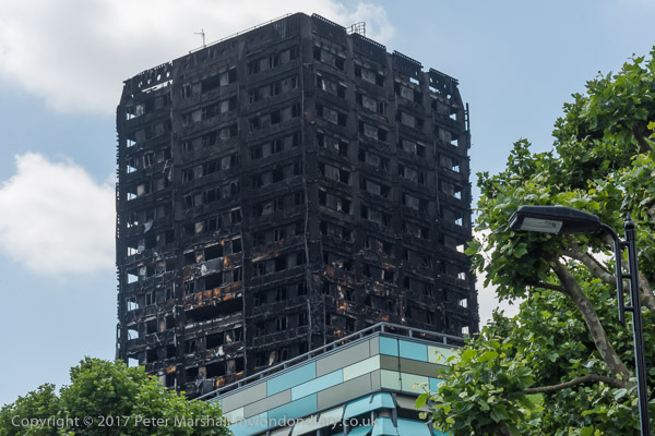
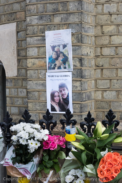
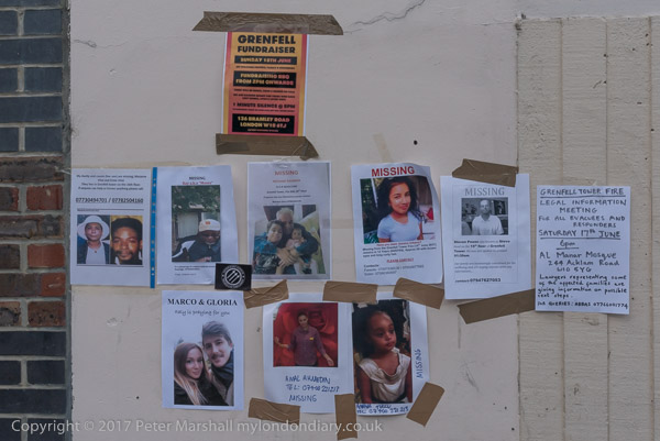
Grenfell and the Tory/DUP Alliance. Two things at the top of the news on Saturday 17th June 2017, the terrible fire at Grenfell Tower three days earlier and the agreement still being negotiated for the Northern Irish Democratic Unionist Party to go into coalition with the Conservative Party after the 2017 General Election had resulted in a hung Parliament.
Grenfell
I’d woken on the 14th June 2017 to the terrible news of the fire at Grenfell Tower in North Kensington, hearing with shock, anger and grief the terrible stories of those trapped and burnt to death in the upper floors of the building. Anger because from the outset it was clear that cuts in the London Fire Brigade made under Boris Johnson and the decisions made by governments , Greater London and the local council had made this and other buildings a fire trap.
I live a little over an hour’s journey from Grenfell, and knew that the area would already be swamped by the media so made the decision to keep away in the days that followed, though I spent some time in research on the web into the causes, particularly reading earlier blogs from some local residents which confirmed my immediate anger.
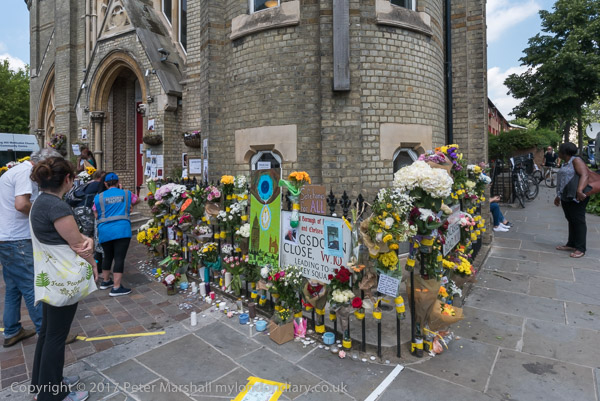
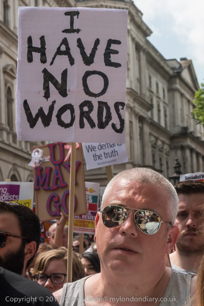
On 17th September I visited the area which I knew slightly before, waling with many others, some carrying flowers on our way to pay respect to the dead, to say a few prayers and to cry a few tears. I wasn’t going as a photographer but as a fellow human being, but I was carrying my camera bag as I was on my way to photograph other events, and I did take just a few pictures.
And I wrote that evening (I’ve corrected a couple of typos):
We don’t need an inquiry to tell us what happened – the various defects that came together are only too obvious, as a number of fire safety experts are concerned. Someone authorised the use of cheap cladding that contained flammable foam, someone let that cladding be applied without fire breaks to save money, Someone approved those unsafe gas lines, someone employed a consultant so the building didn’t get proper fire inspections and so on. Over the years people at Kensington & Chelsea Council (and the TMO they set up) turned an inherently safe building into a firetrap waiting to happen, because to them it was a place where people they didn’t see as people, just numbers who were a burden on the housing department.
Of course it wasn’t just the RBK&C. There were the various government ministers and others responsible for setting standards that let inherently unsafe materials pass – which when tested after Grenfell have given a 100% failure rate. The ministers who dismantled and privatised safety inspections, relaxed and got rid of safety regulations, failed to implement the lessons learnt from earlier fires and so on, most but not all of them under the previous Tory government. And all those pressure groups and ‘think tanks’ pushing the ideas of deregulation, of removing what they called ‘red tape’, the protections that would have saved the lives of those who died.
The victims of Grenfell – certainly a case of mass corporate manslaughter if not murder – deserve justice. They died because they were poor and in council housing and those in authority and the greedy super-rich didn’t think they deserved proper care and decent standards. They deserve justice – and that means fines and imprisonment for those responsible as well as changes in the way that we run things.
Six years on, with a huge and ponderous inquiry having made a fortune for the many lawyers, we have still to see justice. Just another example of our legal and judicial systems swinging into action to push Grenfell into the long grass and to protect the rich and guilty.
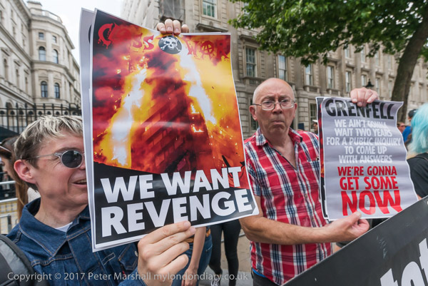
Class War protest Grenfell Murders – Downing St
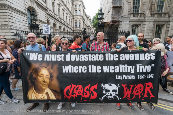
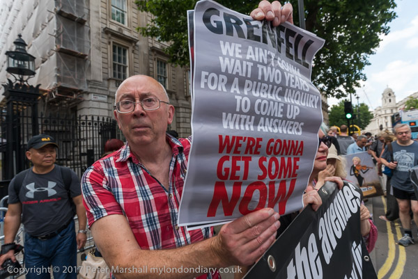
Later that day I was with Class War at Downing Street where they had come to call for revenge over the Grenfell fire and action by the people rather than waiting for a whitewashing public inquiry to report.
Class War say Grenfell is an open declaration of class war by the wealthy elite against the working class, and they have a personal interest in the matter. Grenfell was where Ian Bone first lived when he moved to London and it was there that the first issues of the Class War magazine were written. He and others in the group still knew people who lived there.
This was only a small protest, with people taking it in turns to stand in front of the gates to Downing St holding their banner with a quotation from the US activist, labour organiser, radical socialist and anarchist Lucy Parsons (ca 1853-1942), who fought against racism and for the rights of workers and for freedom of speech from her early years until her death, “We must devastate the avenues where the wealthy live.“
The poster held up by Ian Bone stated “GRENFELL – WE AIN’T GONNA WAIT TWO YEARS FOR A PUBLIC INQUIRY TO COME UP WITH ANSWERS – WE’RE GONNA GET SOME NOW”. Most of the answers were published a month later in a lengthy report by Architects for Social Housing, but Class War seriously under-estimated the obfuscating power of the establishment. Its now SIX years with no justice.
We need fast-track inquiries with minimal legal involvement, perhaps only allowing those who are a part of the inquiry team rather than any representing parties under investigation.
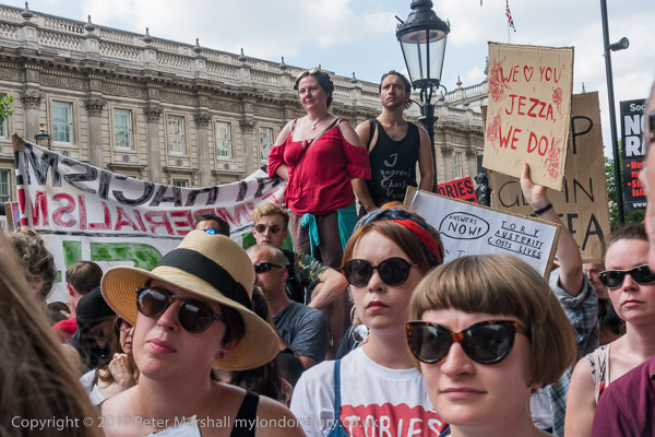
No Tory DUP Coalition of Chaos – Downing St
The 2017 General election had been a close-run thing, and only a concerted effort by Labour officials and right wing MPs had prevented a Labour victory, though the huge extent of their machinations against Corbyn only emerged much later in an unpublished but widely available internal report. But as the results came in you could hear the relief of some leading Labour MPs when their candidates lost in some clearly winnable marginal constituencies.
The result was a hung Parliament with no party having an overall majority. Over the previous parliaments the Northern Irish Democratic Unionist Party had generally operated an informal agreement to vote with the Tories, but now they were able to demand concessions to enter into a formal coalition. Negotiations had begun which were finally agreed on 26 June 2017.
Protesters pointed out the DUP was a party intrinsically linked with Protestant terrorist groups and dominated by a homophobic church which represents a tiny minority of the Northern Irish population.
Speakers included Northern Irish women campaigning for abortion and other women’s rights enjoyed by women in the UK. DPAC spoke about the Tory assault on the disabled, and there were various others.
Among those who spoke were three Labour MPs, Marsha De Cordova who gained Battersea from the Conservatives, Rupa Huq who greatly increased her tiny majority and Shadow Education Secretary Angela Rayner.
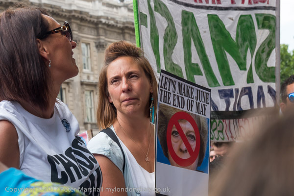
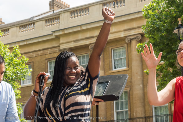
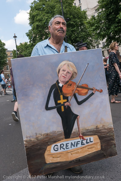
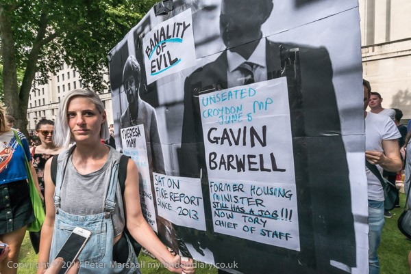
There were also those present who had come to protest about the complicity of Theresa May and unseated Tory MP Gavin Barwell in the Grenfell outrage; Barwell had ignored a fire report made in 2013. Political artist Kaya Mar came with a painting of Theresa May playing the violin with one red-heeled shoe on a coffin labelled Grenfell.
The Tory-DUP agreement has had serious long-term consequences, in particular over Brexit, where it prevented a sensible agreement being reached. Johnson went ahead ignoring the problems and we are still suffering from this. Neither his or May’s agreement were supported by the DUP, but the coalition agreement had greatly increased the importance of their party’s views.
A Submarine, Flats, Pub, Dog, Ducks & Milkmaid is the final post on my walk on Friday afternoon, May 5th 1989. The previous post was Around Camberwell New Road – 1989
I crossed over Camberwell New Road to the southern side, turned own Vassall Road and then left into Langton Road. I’ve not digitised the one picture I took of a house here, nor the single image I made in Lothian Road, but I continued further south along here, lured by the sight of an unusual object in the centre of Akerman Road.
Two vertical concrete towers rose up from a more organic looking low concrete body. Later I was to learn that this was known as the Camberwell Submarine.
I had no idea what this structure was, though clearly it was providing ventilation for some below ground installation. Was it Lambeth’s nuclear bunker, perhaps an underground city? Was there some secret tunnel underneath – though the nearest Underground line was well over a mile away. Later I looked it up to find others had made similar speculations to mine, but of course the real purpose is rather more prosaic.
This is the visible structure of the below ground Myatt’s Fields North Boiler House designed by Michael Luffingham in the mid-seventies for Lambeth Council, and described at the time as Hollamby’s submarine after his boss, borough architect Ted Hollamby. An attempt was made to get it listed ten years ago but failed.
I could only walk around the outside of the submarine and although it had doors at each end, both were locked. In 2007, Mike Urban of Urban75 was photographing it and was invited inside by a maintenance worker and his post reveals some of the hidden secrets of the interior.
Flats, Akerman Rd, Lambeth, 1989 89-5b-26
These are some of the flats on the Myatt’s Fields North which were heated by the submarine. The estate later got a very poor reputation and much was demolished and replaced in controversial redevelopment in 2014, mentioned in a previous post.
I turned down Evandale Road and walked down to the Loughborough Hotel on the corner with Loughborough Road. The earliest record of a pub here – on the corner with what was then Cromwell Rd – was in 1864, and it was built on the site of Loughborough House which was demolished in 1854. This had been the Manor House of Lambeth Wick, home to the 1st Baron Loughborough, Henry Hastings. He had been given his title in 1643 for fighting for the Royalists in the English Civil War and returned to live here after a period of exile in 1661.
In 1900 the hotel was replaced by this splendid new building, designed as an entertainment palace with a large ballroom on the first floor. The name ‘Hotel’ simply meant it was a posher establishment than an inn, and it never had rooms where people could stay.
The nature of entertainment at the hotel changed from the late 1960s as did the local population. The Island Disco, a South Pacific Island themed disco opened in 1967 and various other night clubs followed including the legendary Latin and African music club, the Mambo Inn. There were drag nights too from !969.
All this finished in 2005, when the upstairs room s were turned into flats. The ground floor pub finally closed in 2007 and the former bar is now a café and possibly at times an art gallery.
I turned east along Loughborough Road and made my way to Fiveways, the junction with Akerman Road, Lilford Road and Fiveways Road. This shows the house on the corner with Akerman Raod, which has since been considerably refurbished. This was once the end of a long terrace from the Loughborough Hotel with ground floor shops, but those at this end and some others have been converted to residential.
I continued along Lilford Road, where at number 15 I photographed this small menagerie. I’m pleased to see that the ducks are still there on the short pillars at the front door, though now looking a little worn, but the milkmaid and dog have gone.
Auto Stores, Camberwell, Southwark, 1989 89-5c-63
By now it was getting a little late and I was getting hungry and I made my way quickly along Knatchbull Road towards Camberwell Green to catch a bus back to Waterloo for my train home. I only took this one last picture, though I’m not sure exactly where it was taken around Camberwell Green, though my contact sheet says Camberwell Road.
This is the third and final post on the walk which began with Naked Ladies, 3 Doors & A New Walk. But two days later I was back again on a new walk in South London which I’ll write about shortly
Houses, Camberwell New Rd, Camberwell, Southwark, 1989 89-5b-64
These houses are 137-141 Camberwell New Road and seem fairly typical of the houses along the road, though unlike many of the others these appear not to be listed. I was interested in particulr at the link between 137 and 139, both with the archway and the butress above. I wondered if the terrace at right was a later replacement for an earlier house here, rather more like the house at left.
Pub, Camberwell New Rd, Camberwell, Southwark, 1989 89-5b-66
A dog sits at the entrance of the Taylor Walker pub on Camberwell New Road, with a small plaque proudly noting the brewery was established in London in 1730. They began in Stepney as Salmon and Hare, and only added John Taylor in 1796, becoming Taylor Walker when Isaac Walker became a partner in 1816. In 1823 they moved from Stepney to the Barley Mow Brewer in Limehouse. They were taken over in 1959 by Ind Coope who closed the brewery, continuing to brew beer under their name at Burton until the 1990s, but some London pubs continued to use the brand. The brand name was revived by another company for some pubs for a few years this century but has not gone.
I’m not absolutely sure which pub this was but it was probably the Skinners Arms, now known as The Kennington, on the corner with Foxley Rd. It closed around 2004, reopening as the Black Sheep Bar for a few years before getting its new name around 2012. Someone must remember the “Chute In Saturday Nights With Big Ray” and “Music Mirth & Melody” with “Max & Tom”, if only with dread.
Fineservice TV & Video Repairs is now a shop and post office, but it still has a reccognisble frontage with the two heads on Farmers Road with a matching pair at the other end of its frontage on Wyndham Road.
Flats, Grenfell House, Comber Grove, Camberwell, Southwark, 1989 89-5b-55
I think I walked on up Wyndham Road but took no pictures until I turned down Comber Grove and made this image of the stone ornament in front of Grenfell House, one of several large blocks of solid 1930s London County Council flats in the estate. This stone ball is no longer in the grass but has, like the flats, gone up in the world, and there are now of pair of them on solid brick columns each side of the gateway from the street.
Calvary Temple United Church, Councillor St, Camberwell, Southwark, 1989 89-5b-44
I walked back onto Camberwell New Road and couldn’t resits taking a few more pictures of Calvary Temple, including some slightly closer images of its frontage (not yet digitised) and a repeat of my earlier viewpoint, before making this view which concentrates on the church without the inclusion of a tower block behind it.
Shops, Camberwell New Rd, Camberwell, Southwark, 1989 89-5b-45
This whole block from 227-253 Camberwell New Road is Grade II listed as “14 houses, now mostly commercial premises. Early to mid C19 with several later C19 shop fronts of intrinsic interest.”
I’m not sure my photograph shows that intrinsic interest, but the lettering and clutter on the pavements certainly interested me.
Clifton Cottage, Camberwell New Rd, Camberwell, Southwark, 1989 89-5b-46
Clifton Cottage at 189 Camberwell New Rd conveniently announces it was built in 1833 at the time of the earliest developments on the road which was created under the 1818 Turnpike Act. It is Grade II listed – and was for some time by mistake listed twice. Possibly the confusion arose as from the annoying failure of listings always to include the full street address, or perhaps because the boundary between the two boroughs of Lambeth and Southwark runs down the middle of the road here. I’ve tried hard here to put my pictures into the correct boroughs, but I know I’ve not always got it right everywhere in London.
My walk on Friday 5th May 1989 continued and there will be more in later posts.
Naked Ladies, York House Gardens, Twickenham, Richmond 1989 89-5a-53
I took few pictures in the rest of the month after my walk on Sunday 9th April 1989, my time being taken up with other things. I did make a few pictures on a CND demonstration in Lambeth with family and friends which I’ve yet to digitise, and some when the photography adult class on which I was assisting went to photograph Twickenham’s famous ‘Naked Ladies’, who now have a beer named for them. Some of my pictures of this were made on large format 4×5″ film so I could contact print them using historic processes such as platinum and kallitype, and I helped make at least one on 8×10″ for the tutor.
Upper St Martin’s Lane, Covent Garden, Westminster, 1989 89-4l-13
And there were a few other pictures such as this, made on my way to the Photographers’ Gallery, then in Great Newport St, a short walk around the corner, or on my way to meetings in other parts of London, and a few closer to home.
But my next walk to take pictures came on Friday 5th May when I rushed out of college after around four hours of teaching and jumped on a train to Vauxhall and a bus to the Oval, walking down Foxley Road, then Vassal Rd to Cowley Rd, eager to continue to photograph in the area around Myatt’s Fields. I paused to take half a dozen pictures on the way, but have yet to digitise any of these.
The top end of Cowley Road is in the Vassall Rd conservation area and this terrace is a remnant of the Holland Town Estate development begun by Henry Richard Vassall, Third Baron Holland in 1818 when Camberwell New Road was laid out. This terrace is possibly from around 1830 and its Grade II listing describes it as Early-mid C19.
No 25 at the right of the previous picture is the last house in this section of the street. On the west side of the road, behind me as I took the picture is a large block of redbrick five-storey council housing, Knowlton House, built by the LCC as part of the Cowley estate in 1934-6. There is another similar block, Stodmarsh House further south on the street.
The park here appears to have had a number of names and is now Eythorne Park, though Google Maps hedges its bets by also calling it Myatt’s Field Common Park and on the old A-Z I used on my walks it was Mostyn Gardens, given to Lambeth Borough Council in 1925 who passed on the the LCC in 1958. They extended and renamed it Melbourne Fields. Parts of it were built on in the 1970s the low-rise Myatts Field North council estate in the 1970s and disastrously redeveloped under a Private Finance Initiative programme hit by various cost-cutting directives and carried out with little or no regard for the residents.
You can see these roofs over the mound in the park in the previous picture, though the park is now flat and surrounded by the redeveloped buildings. These buildings looked in good condition in 1989 and the estate looked well designed and a pleasant place to live. But years of neglect by the council meant that in 2004, as Zoe Williams wrote in The Guardian “Myatts Field North in Lambeth, south London, was a byword for what goes wrong on a housing estate. It had been poorly maintained; the interiors were shabby. Garages had become hazardous and were out of bounds; shared spaces were desolate and only teenagers and children used them, “engaged in nothing very positive”, according to a council report at the time.”
The state of the estate in 2004 led residents to vote by a fairly small majority for the council’s plans for regeneration, “demolishing and rebuilding 305 homes, refurbishing 172“, but work only began in 2012, by which time the plans had been considerably altered with cuts to the budget. Five years later when Williams wrote her article the problems with the regeneration were clear, with the refurbished homes poorly plannede and shoddily implemented and the residents many complaints largely simply ignored.
St John’s Schools, Camberwell New Rd, Camberwell, Southwark, 1989 89-5b-62
St John The Divine Junior Mixed and Infants School is still there on Camberwell New Road, though ILEA has long gone and the entrance to the school is now on Warham St, as it probably was when I took this picture. The church itself is a short distance away in Vassall St and is a good example of Victorian gothic by George Edmund Street. The parish was created in 1871.
The school, with buildings in Warham St (then James St) opened in 1872 for 400 children but this building on Camberwell New Road came some years later.
Shops, Camberwell New Rd, Camberwell, Southwark, 1989 89-5b-63
The school building in flanked on both sides by shops and is in the centre of a terrace. Edward Wells & Sons Ltd at 143-145 offered a wide range of printing services. I think the businesses closed soon after I made this and other pictures.
From Longfield Hall I wandered up Knatchbull Road to Cormont Road, which runs halfway around Myatt’s Fields Park on its southwest and northwest sides. I took half a dozen pictures which I haven’t digitised before coming to this on the corner of Brief Street which I think was built as flats. Almost all the buildings in the area are fine examples of late Victorian housing, largely in the Queen Anne style but there is perhaps a slightly overpowering amount of red brick directly onto the streets.
Another finely designed large block of flats a few yards down Brief Street, Burton House, its hedges a few years ago more tidily trimmed but now again reverting to wild. On the opposite side of the street is a short terrace of two storey houses with brief front gardens and Brief Street is appropriately short – a little under a hundred yards in length.
According to Lambeth’s 2018 Character Appraisal for the Minet Conservation Area, “Kennington Boys’ High School (latterly known as Charles Edward Brooke School), Cormont Road opened in 1897.” This was a LCC board school and the Grade II listing states that this building dates from 1912, architect T J Bailey. It is listed on Historic England’s Heritage At Risk Register.
Confusingly – and I hope I have got this right – the school renamed itself Saint Gabriel’s College when it became co-educational as a Specialist Arts and Music College in 2012, and then moved out to Langton Road a few years later.
Again from the Lambeth appraisal, “The former St. Gabriel’s College on Cormont Road opened in 1899 as a training college for Anglican schoolmistresses, the vision of Charles Edward Brooke, a senior curate of nearby St. John the Divine church; the attached chapel was added in 1903.” The style is described as “vaguely Art Nouveau“. In 1989 it was Myatts House, run by the ATC Group of Training Companies and offering courses in Accountancy, Finance, Management and I think Computers, though the final word on the sign is hard to read. Grade II listed.
The building was requisitioned in the First World War, becoming part of the 1st London General Hospital, and was where Vera Brittain was first stationed. Later it became a LCC rest Home. It is now residential, converted to expensive flats as St Gabriel’s Manor.
This is Calais Gate, also Grade II listed and said in the listing to date from the early 20th Century, though the Myatt’s Park history site dates that these large mansion blocks as c. 1895.
Perched on top of the fine stepped gable is a terracotta cat, one of a number of cats on buildings on the Minet estate, though most are rather less prominent. The whole estate was developed by the Minet family who were of French Huguenot origin, and their name is an affectionate or childish French term for a cat, (minette if the cat happens to be female.)
Houses, Calais St, Myatts Fields, Camberwell, Lambeth, 1989 89-4j-22
Substantial houses in Calais St facing the park on the north-east side. I wondered when I took this on the significance of the gateway at left with the cross above, but am no wiser now. Hard to make out from this picture but those are cats heads above the doorway.
Fine railings and decorative elements on these houses at 22 and 24 Flodden Road make them stand out and the absence of cats perhaps suggests these large semidetached Queen Anne style houses were not a part of the Minet development. Instead there are leaves and floral motifs and human heads.
Flodden was the site of a battle in 1513 in Northumberland, close to the border with Scotland when the English Army soundly defeated the army of King James IV of Scotland. England were engaged in a war with France and the Scottish invasion was in support of the ‘Auld Alliance’ they had made with France in 1295.
It was time for me to leave the area, and I walked up Flodden Road to Camberwell New Road to get a bus, coming out almost immediately opposite Calvary Temple of the United Pentecostal Church a few yards to the north of the road in Councillor St.
The church incorporates a memorial stone “laid by William Appleton Esq (Sutton), June 2nd !890″ with the text “Hitherto Hath the Lord Helped Us” (1 Samuel 7:12), naming George Baines Architect and H L Holloway Builder. The church, then Clarendon Chapel, opened as a Baptist church in March 1891, replacing an earlier ‘tin tabernacle’ which had burnt down in 1889. Clarendon Street became Councillor Street some time before 1912 and the church was renamed Camberwell New Road Church, continuing in use for Baptist worship until the 1950s.
It narrowly escaped demolition in 1959 when it was saved by Caribbean immigrants who were looking for a building for their Pentecostal worship and they held their first service there in March 1959. They kept and restored the churches original late Victorian fittings and it remains in use.
Then and now it makes a dramatic composition with the tower block behind, Laird House on Redcar St, one of five 22-storey 210ft blocks on the 1966 LCC Wyndham & Comber Estates.
New Road Bargains, Camberwell New Road, Lambeth, 1989 89-4j-12
There are few if any shops in Myatt’s Fields but several parades within walking distance including on Camberwell New Road where at 243 was New Road Bargains with a small chair fixed above its door and a wonderfully packed window of assorted items. For some years this has been Camberwell Daily, now with a shop front that offers GROCERIES | FRUIT & VEG | OFF LICENCE | NEWS & MAGS.
I might have photographed other shops in the row, but my bus came and I got on it to begin my journey home.