Notting Hill 1990

Notting Hill Carnival, 1990. Peter Marshall 90-821-51_2400

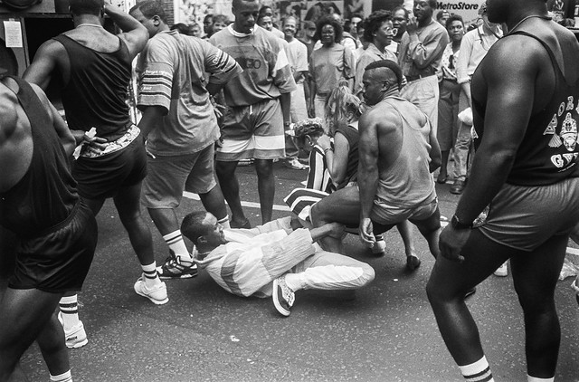
Were we in normal times, today I would be thinking about going to Notting Hill tomorrow for the first of two days of Carnival. Much to my surprise I find it was eight years ago that I last went, having been on holiday away from London several years, and deciding the weather wasn’t really right some others. But perhaps I’m just getting old and was finding the music and the crowds too much some other times. At least this year I don’t have to make a decision.

Notting Hill Carnival, 1990. Peter Marshall 90-822-63_2400

The Notting Hill Carnival’s origins are in a ‘Caribbean Carnival’, an indoor event organised by Claudia Webb in 1959, the year after the Notting Hill race riots. The first procession was an impromptu one in 1966 from a neighbourhood street party, but it was in the mid-1970s that in began to be a major festival with a large attendance. But heavy-handed policing led to battles between mainly Caribbean youth and the police, luridly reported by newspapers and broadcast media which made many of us reluctant to attend the annual event.

Notting Hill Carnival, 1990. Peter Marshall 90-820-14_2400

August was in the 1980s was also a month when I was often in Paris and it was only in 1990 that I decided I had to go and photograph Carnival, and was both deafened and exhilarated by the energy and joy of the event. For the next twenty or so years – with a few exceptions when I was out of the country or crippled by injury – I photographed the event, at first mainly in black and white but later on colour film and then digital.

Notting Hill Carnival, 1990. Peter Marshall 90-822-64_2400

I’ve just spent a day putting my black and white pictures from the first ten years I attended, starting in 1990, onto Flickr. Some of them have been seen before in a number of group shows, including one in Notting Hill itself. I had a small one-person show at the Museum of London in the late 1990s, and put some on the web at Fixing Shadows, one of the first sites showcasing ‘straight photography’ on the web. This led to a 20 print portfolio with comments by George Mentore, published as ‘Notting Hill in Carnival’ in Visual Anthropology Review in 1999. I also showed the same number of prints in ‘English Carnivals‘ at the Shoreditch Gallery and Barbican Library in 2008, and later in the 2018 Café Royal volume, ‘Notting Hill Carnival in the 1990s’.

Notting Hill Carnival, 1990. Peter Marshall 90-828-45_2400

But for the Flickr album, which now contains 260 photographs, most of them published for the first time, I went back to the contact sheets. Most of those early years I went on both the Sunday – Children’s Day and the Bank Holiday Monday, probably averaging around 300 exposures on each. Probably a total of over 6000 images. But some of those were in colour, a few panoramic, so the 260 are from perhaps 4500 black and white frames. They include quite a few I wonder why I haven’t shown them before.

Notting Hill Carnival, 1990. Peter Marshall 90-824-13_2400

Technically they are quite varied, including some I’ve carefully balanced and retouched for publication and others that are untouched raw scans. Not every picture is critically sharp, as I was often working with no time to refocus and sometimes while in the middle of dancing crowds and concentrating on emotion rather than technique.

Notting Hill Carnival, 1990. Peter Marshall 90-818-56_2400

All the pictures in today’s post are from my first year at Carnival in 1990, when I think I was just beginning to get into the subject. More from 1991 and later to follow.


All photographs on this and my other sites, unless otherwise stated, are taken by and copyright of Peter Marshall, and are available for reproduction or can be bought as prints.


Meridian 3

Following the Greenwich Meridian is rather easier since the Ordnance Survey helpfully added it to their 1:25000 maps in 1999, but these pictures were made five years earlier in my project in preparation for the Millennium. I’d had to draw my own pencil line in their maps, which fortunately did show in their outer margins the Longitude at one minute intervals, including 0°00′, so it wasn’t hard to add the line.

I’ve never quite understood why the National Grid doesn’t quite align with this, the Prime Meridian, but presumably there were good reasons for choosing another starting point and working very slightly at an angle. The street maps which I needed to work out my actual route as they had the street names follow the National Grid, though they rather hide this behind their own system of letters and numbers based on half-kilometre squares.

For the northern part of my walk, the Meridian ran roughly down the gap between two pages of my Master Atlas of Greater London, a book too large and heavy to carry on my walks, and I marked out my route with highlighter pens on illegal photocopies of its pages.

There are several crossings of Southend Road, the North Circular Road at this point close to the Meridian which I think was actually a few yards to my east as I took a picture looking roughly west. But the road layout had changed a little from that since my OS map had been revised. It was a view which made a better picture – and close enough to the line for me, as was the level crossing at Highams Park – where again the actual line is a few yards behind me – to the west.

The view of Mapleton Rd and Stapleton Close (wrongly titled Mapleton Drive in my notes) is perhaps a hundred yards west of the Meridian, but close enough for me. The war memorial at the junction of The Ridgeway and Kings Head Hill is spot on target, while Woodberry Way is perhaps around a hundred yards to the west.

Finally, Pole Hill has two markers; the obelisk, set up by the Astronomer Royal to align his telescope in Greenwich due north is on the old Meridian, but the trig point to its left is on the version adopted internationally (except by France) in 1884. Nowadays we use GPS based on the International Terrestrial Reference Frame which has its zero meridian 102.478 metres further east.


All photographs on this and my other sites, unless otherwise stated, are taken by and copyright of Peter Marshall, and are available for reproduction or can be bought as prints.


Meridian 1

One of the blogs about London I keep my eye on and occasionally read with interest is the rather oddly named ‘Diamond Geezer‘, who posts daily articles, usually about his walks or bus rides around some of London’s more obscure areas. As someone who spent around 20 years walking around many of these taking photographs, I often find these interesting even though I don’t share his preoccupation with some of the minutiae of Transport for London’s oddities.

The two most recent of his posts have been Prime Meridian 0° Day 1 and Day 2 and by the time you read this, there will probably be a Day 3. Since he is only walking along the line (or rather as close to it as you can) in Tower Hamlets and Newham there probably won’t need to be a Day 4.


Greenwich Observatory – Peter Marshall, 1985

I was particularly interested because I carried out a similar but rather longer project in 1994-96, completing it despite failing to get any of the Millenium funding which was on offer. I began at what seemed the obvious place, the Royal Observatory in Greenwich – as this was the Greenwich Meridian. My walk, carried out over several days, was rather longer, ending more or less at the Greater London boundary in Chingford – and later I extended it south from Greenwich to New Addington at the southern boundary.

Greenwich Riverside – Peter Marshall, 1985

It was rather harder then to actually trace the Meridian on the ground. There were rather fewer actual markers then and I think no published walks along it. Although my application failed, others were successful and obtained funding to put in new Meridian markers and publish walks at the time of the Millenium and yet more have been added since.

West India Dock – Peter Marshall, 1985

Back in 1994-6 I had to draw my own line on my maps – it was only in 1998 that the line was added to the Ordnance Survey maps – in order to allow people to celebrate the Millennium on it. Back then we had no mobile phones and no GPS – the first phone based GPS navigation system was only introduced by Benefon in 1999 and it was a few years before this became universal.

Greenway & Channelsea River, Stratford – Peter Marshall, 1995

I first published these images on the web in 1996, having then recently acquired a colour film scanner. It wasn’t a very good scanner and getting good results from colour negative film was tricky. I think I scanned most of them again later, but some could still be improved.

Stratford – Peter Marshall, 1995


To be continued…

May and Mayfair 1987

The Fountains, Hyde Park, Westminster, 1987 87-5g-41-positive_2400

I’ve tried on several occasions to photograph the Italian Fountains in Kensington Gardens, an ornamental garden said to have been a gift from Prince Albert to Queen Victoria in around 1860, designed by James Pennethorne and incorporating ideas from their holiday home at Osborne House on The Isle of Wight. There are five main designs on the urns there, including the ram’s heads you see a few times in this picture, a swan’s breast, woman’s head, dolphin and oval. Taken in May when I think the trees in the background are at their best, some in leaf and others still showing their structure. The garden has been renovated since I made this picture.

Connaught Place, Bayswater, Westminster, 1987 87-5g-61-positive_2400

There seems to be a gate to the pavement of Connaught Place in Bayswater, probably to keep out the riff-raff like you and me, and I clearly chose to photograph through it as a frame to the formal architecture of the line of grand porches beyond. Although there are extremely expensive properties in a prestigious address, I find them rather dull, these heavy porches uneasy add-ons to the bland five-storey plain brick behind – which I chose not to include in my picture. But despite the porches, these are really the back doors of these building.

Bayswater Rd, Bayswater, Westminster, 1987 87-5g-63-positive_2400

The houses may have their doors in Connaught Place but the clearly face to Hyde Park, where the row has these magnificent balconies. I also photographed them in landscape format, but need to replace that image on Flickr as I find the negative moved at left to give a double image when I was making the digital camera ‘scan’, probably because the negative holder was not fully closed.

87-5h-24-positive_2400

Shepherd Market in Mayfair describes itself as “a charming small square and piazza with a variety of boutique shops, restaurants and impressive Victorian pubs” and ” A hidden gem known for its wonderful relaxed village-like atmosphere.” It gets its name from Edward Shepherd who developed the area in 1735-46 on open ground where the annual May Fair had been held. Wikipedia comments “It was associated with upmarket prostitutes from its building up until at least the 1980s” and they were still in business when I made these pictures in the area. In 1987 it still retained something of the shabby charm from its really run-down times when it was popular with artists and writers 60 years earlier. The area is something of a maze of streets and alleys and I no longer recall exactly where this picture was taken.

Shepherd Market, Mayfair, Westminster, 1987 87-5i-35-positive_2400

You can still find Da Corradi’s Italian Restaurant and Ye Grapes in Shepherd Market though I think both have changed somewhat are there are now more tables in the narrow street.

Hertford St, Mayfair, Westminster, 1987 87-5h-64-positive_2400

Hertford St runs from Park Lane to Shepherd Market and then takes a turn north to Curzon St. This building is still there on the corner with Shepherd St and I think is a part of an expensive and exclusive private member’s club outside which I’ve recently photographed protests calling for kitchen staff to get a living wage and better conditions of service. The club is on five floors and includes a nightclub, four restaurants, four bars, a private dining room, cigar shop, a courtyard and a roof terrace and has a dress code which prohibits ‘sportswear of any kind’, t-shirts, shorts, sandals and dirty trainers. Personally having watched the kind of people who go into it I’m pleased not to be a member.

Hertford St, Mayfair, Westminster, 1987 87-5h-35-positive_2400

Towering above the western end of Hertford St is the ugly bulk of the London Hilton in Park Lane, the first Hilton to open in the UK in 1963. 331 Feet tall it overlooks Mayfair, Hyde Park and, more controversially at the time of building, Buckingham Palace and its gardens. The hotel is on 28 floors and has 453 rooms and according to Wikipedia is now the 84th equal tallest building in London, though around twenty still under construction will soon edge it out of the top 100, though I think it will remain one of the tallest in the West End – only Centre Point and the Millbank Tower are taller.


Mainly Marylebone

The Evangelical Library, Chiltern St, Marylebone, Westminster, 1987 87-5e-16-positive_2400

The Evangelical Library on Chiltern St in Marylebone was built as a school for the Portman Chapel in 1859 by Christopher Eales with minor alterations in 1880 and was Grade II listed in 1994 as “an early surviving example of a church school in a city centre an early surviving example of a church school in a city centre”.

The Library began as the Beddington Free Grace Library, housed at first in sheds and later a brick building in Beddington, before moving to South Kensinton in 1945 and then here in 1948. It grew to contain around 80,000 books and periodicals relating to Protestant and Reformed Evangelical Christianity including many rare and valuable Puritan texts. Over the years the Grade II listed building deteriorated and the the costs of renovation to prevent damage to the volumes led to the library moving out in 2010 to cheaper premises in Bounds Green.

Meacher, Higgins & Thomas, Chemists, Crawford St, Marylebone, Westminster, 1987 87-5e-43-positive_2400

You can still see this shopfront of Meacher, Higgins & Thomas, established in 1814 as chemists in Crawford St, Marylebone, and it has changed little from when I took this picture, though it has a larger illuminated sign at right and those large glass containers of coloured water which marked out every dispensing chemist in my youth disappeared from the upper windows a few years ago.

Marble Arch, Westminster, 1987 87-5f-25-positive_2400

It was a warm day in May and the closely cropped grass by the fountains at Marble Arch seemed a good place to have a rest. I think I probably sat on a bench or wall to eat my sandwiches and afterwards probably made my way down the steps to the public toilets and then under the subway into Hyde Park. Both now gone.

Hertford House, Manchester Square, Marylebone, 1987 87-5f-53-positive_2400

Hertford House, Manchester Square, Marylebone. Hertford House was originally called Manchester House, as it was built in 1776-88 for the 4th Duke of Manchester who apparently wanted to live here for the duck shooting. Presumably he had exterminated them all by 1791 when it briefly became the Spanish Embassy, and then in 1797 it became the home of the 2nd Marquess of Hertford who held many grand parties there, including a Ball celebrating the defeat of Napoleon. Despite this in 1836 it was let to the French as their embassy until 1851.


Hertford House, Manchester Square, Marylebone, 1987 87-5f-55-positive_2400

The 4th Marquess of Hertford preferred to live in Paris, but used the house to store his art treasures, and when the Commune took over Paris briefly in 1871, his illegitimate son Richard Wallace moved back into the house and renamed it Hertford House. He had the house extended in all directions to fit in all the stuff he brought back with him, and what we see now, including the portico, is largely the result of these modifications by architect Thomas Ambler. After his death in 1890 the house was converted into a public museum, The Wallace Collection.

I visited it many years ago and found it a rather depressing experience, but the interior has recently undergone a considerable refurbishment and the experience may well be less oppressive.

Hinde House, Hinde St, Marylebone, Westminster, 1987 87-5f-65-positive_2400

Hinde St runs west out of Manchester Square and the impressive church at the right of this picture is Hinde Street Methodist Church. The first church was built here in 1807-10 but this was largely or wholly demolished and a new Wesleyan church, designed by James Weir, opened in 1887. It remains one of London’s leading Methodist Churches.

Hinde House is a block of expensive leasehold flats, where a two bed flat might cost you a million or two.

Ukrainian Catholic Cathedral, Duke St, Mayfair, Westminster, 1987 87-5g-11-positive_2400

Another place where I’ve often eaten my sandwich lunch in Central London is Brown Hart Gardens on Duke St in Mayfair. The extravagant building opposite this raised stone garden is the former Kings Weigh House Chapel by Alfred Waterhouse, built 1888-91 as a Congregational Church. It is a far cry from the more restrained and often classical church buildings I associate with this non-Conformist denomination. Congregational Churches in the past were staunchly independent, their life ruled by the decisions of the members, reached always by consensus, and I think most that I’ve been familiar with would be far too proud of their Puritan origins to have considered such a design. It seems to me very much more suited to its current use as London’s Ukrainian Catholic Cathedral.

Brown Hart Gardens, Mayfair, Westminster, 1987 87-5g-24-positive_2400

Brown Hart Gardens started life as a real garden between large blocks of working-class dwellings built by The Improved Industrial Dwellings Company in 1886-7, Balderton Buildings and Chesham Building. These were taken over by the Peabody Trust in the 1970s. On Chesham Building is a plaque to the first Duke of Westminster Hugh Lupus, recording that through these and other buildings he provided accommodation for “nearly 4000 persons of the working class’ and naming him “The Friend and Benefactor of His Poorer Brethren”.

The land was a part of the Grosvenor Estate, and the buildings were part of an extensive slum clearance programme in the area. The Duke of Westminster insisted on a garden being created between the two streets of flats, then called Brown St and Hart St, and this was created in 1991.

It didn’t last long. In 1902 the site became an electricity sub-station, and this was built with domed pavillions at each end and completed in 1905. The Duke of Westminster insisted that a paved ‘Italian Garden’ be provided for local residents to compensate for the loss of the former garden, and this remained open to the public until shortly after I took these pictures in May 1987. The London Electricity Board then closed the area. It was refurbished from 2007 on and reopened to the public in 2013, with a cafe around the pavilion at the west end.

You can see more pictures on Page 4 of 1987 London Photos


More Marylebone 1987

Marylebone Station, Marylebone, London, 1987 87-5d-36-positive_2400
Marylebone Station

I suppose for many people Marylebone is the name of a station (though some will connect it more with its cricket club.) The station was the last London terminus to be built, opened in 1899 and never completed, with only four platforms of eight ever built. It lost most of its express services in 1960 and was only saved from closure and demolition by a thriving commuter service from Aylesbury. I think the train here must be one of those used on that route. Marylebone provided one of the few successes of the privatisation of British Rail, generally a triumph of dogma over sense, with the setting up in 1996 of Chiltern Railways. Among other services they provide a pleasant route to stations to Birmingham with comfortable trains and some very cheap tickets, part of the old ‘Great Central’ Network which could probably have been revived much more sensibly and at far lower cost than the ridiculous HS2 project.

Regents Canal, Lisson Grove, Westminister, 1987 87-4d-21-positive_2400

I had wrongly captioned this image earlier, thinking it showed the mouth of the Maida Hill tunnel, but although it was taken very close to there it is actually looking away from it, and the black hole at the end of the water is the bridge under Lisson Grove. The tunnel is hidden from my view here, some way down and a few yards to the right of where I was standing.

Entrance, Maida Hill Tunnel, Regent's Canal, Lisson Grove, Westminster, 1977 87-5c-41-positive_2400

I went down the steps leading to the canal towpath and took a picture of a boat entering the tunnel. The previous image shows the top of the structure crossing the canal over the mouth of the tunnel which carries electrical cables from the nearby Grove Road power station in St. John’s Wood which closed in 1969 – with the site now housing two major National Grid sub-stations.

There is no towpath in the 249m long tunnel, which is only wide enough for a single narrow boat; boats have to wait at the entrance until the tunnel is clear.

Regent's Canal, Lisson Grove, Westminster, 1977 87-5c-54-positive_2400

Here you see the canal under the cable bridge.

CEGB,  Lodge Rd, St John's Wood, Westminster, 1987 87-5c-45-positive_2400

And this is the long wall of the power station site in Lodge Road. Although it looks very forbidding I’m told it was – at least in the old days – a very pleasant place to work. Coal used to come to the power station from a siding off the lines into Marylebone Station, though possibly at some time it also came by canal.

Volkswagen, Lodge Rd, St John's Wood, Westminster, 1987 87-5c-46-positive_2400

The Volkswagen workshops were opposite, and a little further west on the south side of the canal were the works of the confusingly named Thames Bank Iron Company, Iron Founders and Heating Engineers who made radiators and other heating equipment, and, according to their lorry parked in front of the building next to some pipes, Drainage Systems.

Thames Bank Iron Company, Lisson Grove, Westminster, 1977 87-5c-43-positive_2400

The pictures show a rather different side of Marylebone – and indeed London – than we now normally think of. They are a stone’s throw from the leafy streets of St John’s Wood with its billionaire oligarchs and from Lords Cricket Ground. But until a few years before I made these pictures, London was very much a manufacturing city. Things had been changing for some years, but it was Thatcher that really put the boot in, moving the country away from manufacturing and into services. And this de-industrialisation was one of the themes behind my pictures of a post-industrial London.

More pictures on page 4 of my 1987 London Photos.


All photographs on this and my other sites, unless otherwise stated, are taken by and copyright of Peter Marshall, and are available for reproduction or can be bought as prints.


Portobello Rd 1987

Street Musicians, Portobello Rd, Notting Hill, Kensington & Chelsea, 1987 87-4c-13-positive_2400

I can’t now remember why I went to Notting Hill in April 1987 as it wasn’t quite on my plans for taking pictures at the time, and it was clearly only a fairly brief visit, walking up the Portobello Rd, usually the kind of tourist trap which I was then trying to avoid. It was perhaps the end of my walk with my son along the Paddington Arm of the Grand Union, leaving it at Great Western St and walking down to catch the tube from Notting Hill Gate.

Street Musician, Portobello Rd, Notting Hill, Kensington & Chelsea, 1987 87-4c-15-positive_2400

I wasn’t at the time very familiar with Notting Hill, at least outside various works of fiction such as Colin MacInnes’ ‘Absolute Beginners’ written in 1959 and including some graphic descriptions of the 1958 Notting Hill ‘riots’. a series of attacks by white youths, mainly “Teddy Boys”, on black residents of the area. A great book about an extremely cool teenage photographer which was made into a extremely poor film musical, which flopped despite a score by Gil Evans, title track by David Bowie (which reached No 2 in the charts) and contributions from other pop and jazz luminaries including Paul Weller, Ray Davies, Sade, Slim Gaillard and Smiley Culture.

Street Musician, Portobello Rd, Notting Hill, Kensington & Chelsea, 1987 87-4c-16-positive_2400

It may well have been the film and all the publicity around it which prompted me to walk on past Westbourne Grove station and down Portobello Rd to Notting Hill Gate. And it will certainly have been my interest in jazz which made me stop and listen and take pictures of a small combo playing on the street, deliberately choosing to work through the crowd.

Barrel Organ, Portobello Rd, Notting Hill, Kensington & Chelsea, 1987 87-4d-11-positive_2400

All of these pictures were I think taken on my Leica M2, which by then had a 35mm f1.4 Summilux almost permanently attached. It was a lens I had lusted over in the window of a secondhand shop in Camden for some time before handing over around a month’s salary. After that the 50mm collapsible f2.8 Elmar saw very little use; later I got a 90mm f2.8 too, but found that gave such a small viewfinder image it was almost unusable, except perhaps for a few distant landscapes.

Portobello Rd, Notting Hill, Kensington & Chelsea, 1987 87-4d-63-positive_2400
Portobello Rd, Notting Hill, Kensington & Chelsea, 1987 87-4d-65-positive_2400
Portobello Rd, Notting Hill, Kensington & Chelsea, 1987 87-4d-41-positive_2400

I didn’t take many pictures, but you can find a few more on page 4 of my 1987 London Photos.


All photographs on this and my other sites, unless otherwise stated, are taken by and copyright of Peter Marshall, and are available for reproduction or can be bought as prints.


Paddington Arm 1987

Paddington Arm, Regents Canal, Westway, Paddington, Westminster, 1987 87-4a-23-positive_2400
Paddington Arm, Regents Canal, Westway, Paddington, Westminster, 1987

You can just see the canal through the open hatch and across the galley area of the narrow-boat Crystal closest to the camera, but the view struck me as a remarkable interlocking of the boats, roads and buildings, different eras of construction and transport. The Westway here sits on top of the Harrow Road bridge over the canal, the Paddington Arm of the Grand Union which was opened in 1801. (Confusingly there is a separate Harrow Road bridge across the canal a hundred yards northwest and yet another a kilometre further on.) At right we have the concrete architecture built for the road operations of British Rail in 1968-9, around the same time as the Westway which opened in 1970. Its building made very clear the tremendous damage that building urban motorways caused to the city.

Footbridge, Lord Hill's Rd, Westbourne Green, Westminster, 1987 87-4b-12-positive_2400
Footbridge, Lord Hill’s Rd, Westbourne Green, Westminster, 1987

There was just something zany about this view that appealed to me, with the smooth curve of the metal lamp support and the jagged line of the concrete bridge., and the two circular objects, lamp and mirror and that dagger of a church spire with its cross.

Regents Canal, Little Venice, Westminster, 1987 87-4b-23-positive_2400
Regents Canal, Little Venice, Westminster, 1987

A rather more conventional view of the canal and a canal bridge, though I did deliberately include in the foreground those rails and slope leading to nowhere. This is the bridge at the west end of Little Venice, and takes Westbourne Terrace Road across to Blomfield Rd at the right of the picture. Google Maps names this place as the Little Venice ‘Ferry Terminal’.

Footbridge,Blomfield Rd, Maida Vale, Westminster, 1987 87-4b-26-positive_2400
Footbridge,Blomfield Rd, Maida Vale, Westminster, 1987

The north end of the footbridge in a picture above, which linked Lord Hills Road and Blomfield Rd. Here I took a simpler approach to its concrete edge, making it a jagged diagonal, emphasized by the handrails. On one side of it the graffiti, to its right the regularity of the houses, probably dating from around 1850, in Blomfield Rd. The footbridge has since been replaced by a rather less interesting metal bridge.

The Blomfields came over with William the Conqueror in 1066, their name deriving from the village of Blonville-sur-Mer in Calvados, Normandy. There were many of them by the 19th century when this road was named, and among them several bishops, well-known architects etc. I suspect it was named after Charles James Blomfield (1786 – 1857)  who was Bishop of London from 1828 until he resigned due to ill health in 1856.

Regents Canal, Blomfield Rd, Little Venice, Westminster, 1987 87-4b-43-positive_2400
Regents Canal, Blomfield Rd, Little Venice, Westminster, 1987
Regents Canal, Blomfield Rd, Little Venice, Westminster, 1987 87-4b-44-positive_2400

This area next to the Westbourne Terrace Road bridge and opposite the Canal Offices used to be home to a strange collection of stone works, but these were removed and for some years this was just an empty patch of grass. It is now a ‘wildlife refuge’, not for big game like those here, but, thanks to Edward Wilson Primary School, is The Bug Hotel, Bloomfield Garden.

Regents Canal, Blomfield Rd, Little Venice, Westminster, 1987 87-4b-45-positive_2400
Regents Canal, Blomfield Rd, Little Venice, Westminster, 1987
Westway, Regents Canal, Westbourne Grove, Westminster, 1987 87-4c-22-positive_2400
Westway, Regents Canal, Westbourne Grove, Westminster, 1987

Finally my young assistant takes a rest (and a photograph) by the canal underneath the Westway.

All pictures were taken in April 1987 and are from my Flickr album 1987 London Photos which now contains over 700 photographs.


All photographs on this and my other sites, unless otherwise stated, are taken by and copyright of Peter Marshall, and are available for reproduction or can be bought as prints.

There are no adverts on this site and it receives no sponsorship, and I like to keep it that way. But it does take a considerable amount of my time and thought, and if you enjoy reading it, please share on social media.
And small donations via Paypal – perhaps the cost of a beer – would be appreciated.


Camden and more, 1987

Gilbey House, Regents Canal, Camden, 1987 87-3a-36-positive_2400
Gilbey House, Regents Canal, Camden, 1987

This view will be familiar to the millions of people who flock to Camden Lock, now one of London’s main tourist attractions. The Gilbey brothers who had volunteered to go abroad to work in a hospital during the Crimean War returned to London and set up a wine and spirit business in 1857. As wines from France and elsewhere on the continent had to pay heavy duties they successfully promoted wines from the British Empire, particularly the Cape. The duties on continental wines were lowered in 1861 and Gilbey’s sold those as well, supplying the off-licences which grocers had been allowed to open by Gladstone in 1860.

Gilbey House, Regents Canal, Camden, 1987 87-3a-12-positive_2400
Gilbey House, Regents Canal, Camden, 1987

They added other drinks, sherry, port, whisky and in 1872 Gilbey’s London Dry Gin which made their name familiar in Britain and throughout the Empire. They built their gin distillery in Camden and soon had a large area of offices and stores around Oval Rd. But in 1962, following various mergers, Gilbey’s left Camden and moved to Harlow New Town.

Popbeat Records, Stucley Place, Camden, 1987 87-3b-06-positive_2400
Popbeat Records, Stucley Place, Camden, 1987

Stucley Place is just a few yards from the now often crowded Camden High St, just behind The Elephant’s Head. I think it had already become a rather trendy area by 1987, a stone’s throw from the TV AM studios in Hawley Crescent.

TV AM, Hawley Crescent, Camden, 1987 87-3b-05-positive_2400
TV AM, Hawley Crescent, Camden, 1987

This was the street side of the building, probably rather better known for the eggs in egg cups on the canal side of the former Henlys building. To me it seemed peculiarly tacky.

Bridge, Regents Canal, Camden, 1987 87-3a-34-positive_2400
Bridge, Regents Canal, Camden, 1987

The bridge and locks are still there, and are now pretty much tourist central, and even back in 1987 there are still quite a few people visible if you look closely. But it might now be difficult to get just 3 pairs of people actually on the bridge.

These locks held up the opening of the canal for several years as originally they were built in 1814 as boat lifts to conserve water. Sir William Congreve, who had developed many novel ideas, but was best known for the rockets he made for military use, designed a hydro-pneumatic canal lift with twin caissons. The canal company modified his designs and they were built by Henry Maudslay and Co. The lifts worked for a few months, though they were difficult to operate, but soon failed when they were handed over to the canal company. Following angry arguments with the three parties each blaming the others, the Regent’s Canal company decided to replace them with the conventional locks now present.

Undoubtedly had they been built to the original designs there would have been fewer problems, but the manufacturing tolerances and sealing materials of the day would have made them unreliable and needed frequent maintenance. It was a great idea but many years ahead of its time.

The Cleveland, Post Office Tower, Cleveland St, Fitzrovia, E=Westminster, Camden, 1987 87-3a-54-positive_2400
The Cleveland, Post Office Tower, Cleveland St, Fitzrovia, Westminster, Camden, 1987

Two rather curious buildings in the same picture. The Cleveland Pub later became a restaurant and then a bar, remaining in use until around 2015 and was demolished I think in 2019. The Post Office Tower is still there.

Langham Works, Great Portland St, Westminster, 1987 87-3a-63-positive_2400
Langham Works, Great Portland St, Westminster, 1987

The 13.8 acres of the Langham Estate stretch from the Euston Road to Oxford St in an area property developers call ‘Noho’, but everyone else knows as Fitzrovia. In 2008 when billionaire tax exiles the Candy brothers named the block of flats they were developing on the former Middlesex Hospital site Noho Square, local residents responded with a “say no to Noho” petition.

Although my contact sheet places this building on Great Portland St, I cannot now find it on the street. It may have been demolished, or possibly I had wandered down a side street and not noted the fact. Please let me know if you recognise it somewhere.

University of Westminster, New Cavendish St, Westminster, 1987 87-3a-65-positive_2400
University of Westminster, New Cavendish St, Westminster, 1987

In 1970 the Regent Street Polytechnic became the Polytechnic of Central London, one of 30 new polytechnics formed in 1970 awarding degrees from the Council of National Academic Awards. It became the University of Westminster in 1992. This building is still at 115 Cavendish St, though it has added an extra floor since I took this picture in 1987. In the background of this picture you can see the Post Office Tower.


All photographs on this and my other sites, unless otherwise stated, are taken by and copyright of Peter Marshall, and are available for reproduction or can be bought as prints.


Marylebone musings

Joseph Bros, Textiles, Great Portland St, Fitzrovia, Westminster, 1987 87-3e-45-positive_2400
Joseph Bros, Textiles, Great Portland St, Fitzrovia, Westminster, 1987

Joseph Bros (Textiles) Ltd according to Companies House is dissolved, last filing company reports in 2006, though some online directories still list it at an address in Finchley which appears to be a garage. But the building is still there, with its ground floor occupied until recently by an “avant-garde” cosmetics company claiming inspiration from Salvador Dali claiming a “cosmetic artistic approach to stop time and restore youthful appearance.” Seeing what Dali did with clocks in his ‘The Persistence of Memory’ and other works, I don’t think I’d want to entrust my own ‘clock’ to them.

Park Crescent, Marylebone, Westminster, 1987 87-3e-21-positive_2400
Park Crescent, Marylebone, Westminster, 1987

John Nash’s Park Crescent, built in 1812-21 for the Prince Regent and still owned by the Crown Estate is of course Grade I listed, although only its facades are orginal, everything behind them having been restored in the 1960s. They had been badly damaged by bombing in 1940.

According to John Summerson‘s classic work ‘Georgian London’ published in 1945 (my copy is of the 1947 reprint though bought a little later) “Nash inaugurated the real stucco age with the building of Park Crescent in Parker’s Roman Cement in 1812“. He also comments that “the simple appropriateness of Park Crescent with its Ionic colonnades is beyond criticism“.

All Saints Church, Margaret St, Fitzrovia, Westminster, 1987 87-3e-02-positive_2400
All Saints Church, Margaret St, Fitzrovia, Westminster, 1987

All Saints Church in a kind of fantasy gothic called for a very different treatment. It was designed by William Butterfield in 1850 and completed in 1859. Another Grade I listed structure it has been described by Simon Jenkins as “architecturally England’s most celebrated Victorian church” and was pioneering in its use of brick rather than the traditional gothic stone. It set a style that would be much copied for the next 20 years though largely less flamboyantly.

I’ve always felt it would be a good location for a horror film, but is actually a leading centre for Anglo-Catholics in the Church of England.

West London Synagogue, Upper Berkeley St, Marylebone, Westminster, 1987 87-3d-52-positive_2400
West London Synagogue, Upper Berkeley St, Marylebone, Westminster, 1987

Quite in contrast is the West London Synagogue, Upper Berkeley St, Marylebone, Westminster, opened in 1870. The congregation had split away from the Sephardi and Ashkenazi synagogues to worship as “British Jews”, adopting a practice based on the “written Torah”. In 1940 they becamae a part of mainstream Reform Judaism.

The architectural style of the building, by Henry David Davis (1838/9-1915) and Barrow Emanuel (1841-1904), is described as Neo-Byzantine, and is certainly unlike their other works I’ve been able to identify. As well as some artisanal blocks of flats for the East End Dwellings Company they also designed the City of London School for Boys still on Victoria Embankment. The synagogue seems to me a slightly odd amalgam of a fortress and a triumphal gateway.

Off-licence, Upper Berkeley St, Marylebone, Westminster, 1987 87-3d-51-positive_2400
Off-licence, Upper Berkeley St, Marylebone, Westminster, 1987

I was amused by the shop sign and not at all sure that I understood it when I took this photograph of what appears to be a rather up-market off-licence. I’m still not sure about it, with a star, arrow and what seemed to me half a lyre with the text ‘E du V’. Doubtless there is some obvious cultural reference which is lost on me, and hopefully someone will point out my ignorance in response to this post.

The reflection in the window clearly indicates it was on a corner of Upper Berkeley St, though I’m not sure on which corner, possibly of Seymour St. It is surely long gone.

St Mary's Church, Wyndham Place, Marylebone, Westminster, 1987
St Mary’s Church, St Mary’s School, Wyndham Place, Bryanston Square, Marylebone, Westminster, 1987

The church, listed Grade I, was designed by Robert Smirke and built in 1823-4. There is a very full description of the church in ‘A Topographical and Historical Account of the Parish of St. Mary Le Bone’ by Thomas Smith, printed and published in 1833 by John Smith and available at the Internet Archive. The descirption ends on p105-6 with these comments:

It would have been desirable, if possible, to have procured a site for this church in a more central part of the District than that which has been assigned to it. In short, it should almost seem as if the greatest possible pains had been taken to select a site, in all respects the most inconvenient for the majority of the congregation ; it being surrounded by streets of worse than a second rate description.

If it be said, that the accommodation of the poor has been principally consulted the answer is the poor are always sure to fill the free seats allotted to them wherever the service of the Church of England is decently and impressively performed. The tower and cupola of this church form a tolerably picturesque termination to the view from Cumberland Gate, Hyde Park.

Internet Archive
Bryanston Square, Marylebone, Westminster, 1987 87-3d-21-positive_2400
Bryanston Square, Marylebone, Westminster, 1987
St Mary's School, Wyndham Place, Marylebone, Westminster, 1987  87-3d-11-positive_2400
St Mary’s School, Wyndham Place, Marylebone, Westminster, 1987