After Christmas – Brentford to Hammersmith was one of our more interesting walks in London to walk off our Christmas excesses in recent years. For once I’m not sticking religiously to my usual practice and this was three years AND one day ago, and the four of us set out on 27th December 2018.
Often in recent years we’ve gone away in the period after Christmas to visit one of our sons and his family in Derbyshire, with some great walks in the areas around where they have lived, and there are pictures from these on My London Diary, but in 2018 my other son and his wife were staying with us and came for this walk.
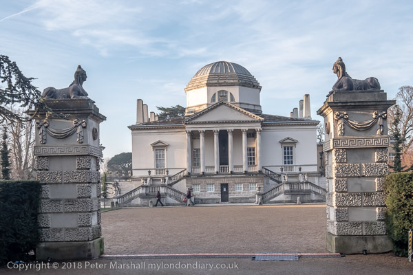
Public transport in the period between Christmas and New Year is at best restricted and rather unreliable, and 2018 was no exception and this always limits our starting point. Even for this relatively local walk what would have been just a short direct train meant taking the train to Twickenham and then catching a local bus to Brentford. And on our return trip again a bus took us back to Twickenham for the train home. It meant less time for walking and we had to abandon the idea of actually going inside Chiswick House in order to complete the relatively short walk of 5-6 miles before it got dark.
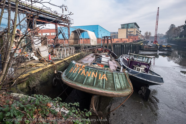
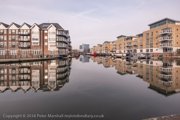
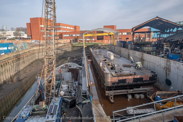
Brentford, and particularly the Grand Union Canal where we began our walk is now very different from how I remember it – and indeed since I first went back to photograph it in the 1970s. Commercial traffic on the Grand Union came more or less to an end in the early 1970s. What was once canal docks and wharves by the lock where boats were gauged and tolls charged the sheds have been replaced by rather uglier flats and a small marina.
Walking by the canal towards its junction with the River Thames there are areas which still look much as they did years ago, and some rather more derelict than they were then. This is a side of Brentford invisible from the High Street but with much of interest. Probably in the next few years this too will disappear as gentrification advances.
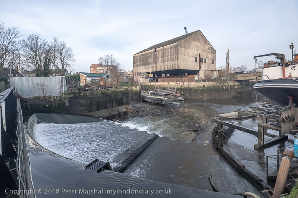
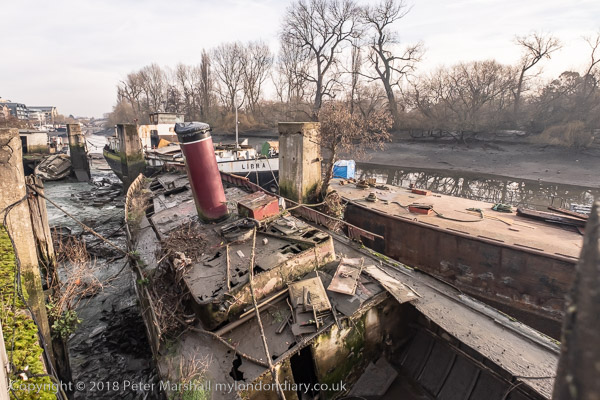
Shortly before the lock leading to the Thames, the River Brent which is here combined with the canal runs over a weir to make its own way to the main river. There are still working boatyards in the area around here, though a little downstream more new flats and a part of the Thames Path here was closed and a short diversion was necessary.
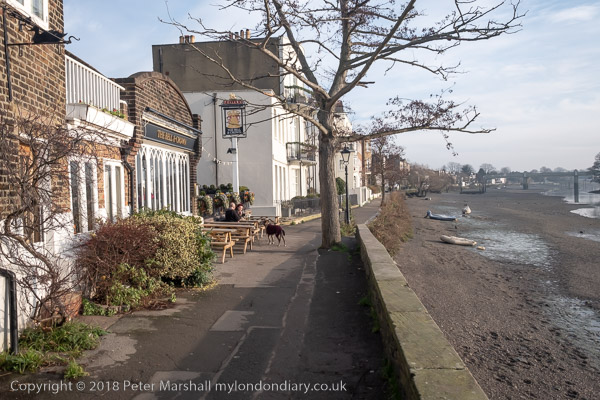
We continued along past new riverside flats and a new private footbridge to the recently revivied boatyard on Lot’s Ait to an area of open space which was a part of the old gas works site, then along the riverside path past more new flats to Kew Bridge and Strand on the Green. Here it was warm enough to sit in the sun and eat our sandwiches before leaving the river to walk to Chiswick House Gardens.
I’d planned to get here for lunch, perhaps spending an hour or so going around the house and then perhaps a drink in the cafe, but there was no time thanks to the rail problems, so we briefly visited the toilets before heading on to St Nicholas’s Church and Chiswick riverside.
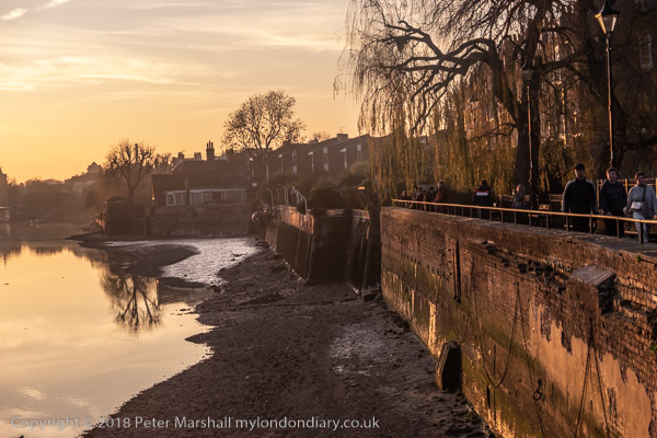
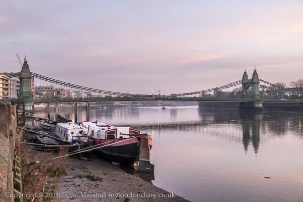
From there it was a straight walk by the river to Hammersmith Bridge, arriving around sunset with some fine views along the river – and then the short walk to the bus station for the bus back to Twickenham and the train home. The two bus journeys made our travel take much longer, but you do get some interesting views from the top deck of a double-decker and the journey was intereresting at least until it got too dark to see much.
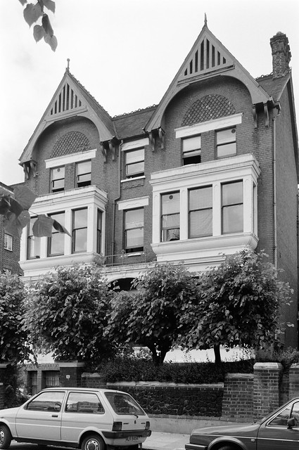
Abercorn Place, St John’s Wood, Westminster, 1988 88-7e-41
Long ago St John’s Wood was a real wood, part of the Forest of Middlesex, and was the property of the Knights Hospitaller of St John of Jerusalem who were based in Clerkenwell. Pregiously it had belonged to the Catholic Poor Fellow-Soldiers of Christ and of the Temple of Solomon (better know as the Templars) who were suppressed in 1312. Henry VIII grabbed the land in 1539 when he dissolved the monasteries during the Reformation, but Charles II gave it to one of his mates in settlement of a debt of £1300, and eventually most of it was sold to a city wine merchant, Henry Samuel Eyre in 1733, and much of the area remains the Eyre Estate. Other parts belong to Harrow School.
Development on the Eyre estate began in 1809 The area was developed as an area for the growing upper middle class, with many detached and semi-detached villas with large gardens, the first garden suburb anywhere in the world. Some later were replaced by blocks of flats and terraces of housing, but the area remains one of the most expensive around London. It’s not an area where I often felt at home.
In 2011 I was able to go behind some of the high walls and photograph the ‘Secret Gardens of St John’s Wood‘ in a project initiated by Mireille Galinou of the Queens Terrace Café and shown there in November 2011, but there were still many impenetrable behind high walls, some protected by security guards with suspicious bulges in their clothing. But in 1988 I kept to the streets.
These flats are at the west end of Abercorn Place at its corner with Maida Vale at the rear of Wellesley Court, architect Frank Scarlett, built in 1938. Perhaps surprisingly the St John’s Wood Conservation Area is carefully drawn to exclude this set of expensive private flats.
Nugent Terrace, St John’s Wood, Westminster, 1988 88-7e-43
There are still shops in Nugent Terrace, but I think this rather high-class cobblers is long gone. I was amused at how the figurines chosen matched the area.
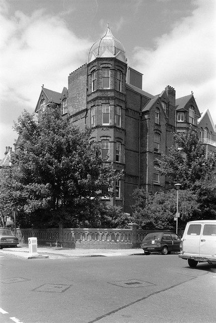
Hill Rd, St John’s Wood, Westminster, 1988 88-7e-46
This remarkable mansion block, Mortimer Court, on the corner of Hill Road and Abbey Road is certainly not typical of the area, and I have to apologise that my picture fails to record the full horror of its architecture, best appreciated from the opposite side of Abbey Road. It can be seen on the web sites of many of London’s estate agents.
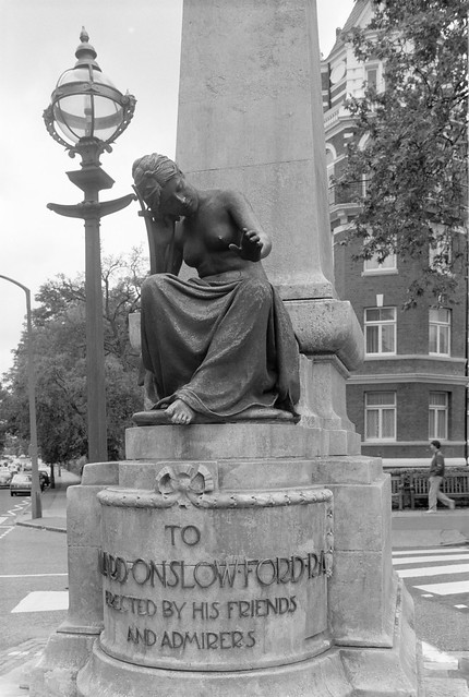
Onslow Ford, memorial, sculpture, Andrea Carlo Lucchesi, Abbey Rd, Grove End Rd, St John’s Wood, Westminster, 1988 88-7e-35
English sculptor Edward Onslow Ford RA (1852—1901) was one of the leaders of the British New Sculpture movement of the 1880s, becoming famous for portrait busts and roundels of many leading figures including Ruskin, Millais, Thomas Huxley and Herbert Spencer. A number of his statues including that of Rowland Hill remain on public display.
He produced a long series of “bronze statuettes of adolescent girls in poses loosely derived from mythology or allegorical themes” some of which were also sold widely in smaller scale copies for Victorian homes, though they might not be appreciated now. The monument in St John’s Wood, close to his home was sculpted by his former studio assistant Andrea Carlo Lucchesi and based on one of Ford’s sculptures.
It is probably a punishable offence to go to Abbey Road and not take a photo of the now famous studios, though I resisted any urge to photograph the famous pedestrian crossing nearby.
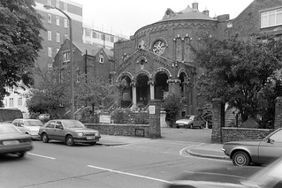
The Baptist Church on Abbey Road was founded in 1863 by a Mr Stott, a preacher from Hyde Park, who engaged leading church architects Habershon & Pite to build this Grade II listed structure in a ‘Free Byzantine’ style.
In 1874 the Abbey Road and St John’s Wood Mutual Benefit Building Society was formed in what was then the Free Church. This later became Abbey Road and St John’s Wood Permanent Building Society and in 1944 joined with The National Building Society to beceome the Abbey National Building Society, which sadly demutualised in 1989 and in 2004 become wholly owned by the Spanish Santander Group.
Abbey Rd, St John’s Wood, Westminster, 1988 88-7e-25
This adjoining pair of gate-posts is no longer on Abbey Road, and the block of flats at No 20 have had something of a face lift since 1988. But to me they looked so much like an adult and child – and were perhaps a deliberate attempt to outdo the Joneses.
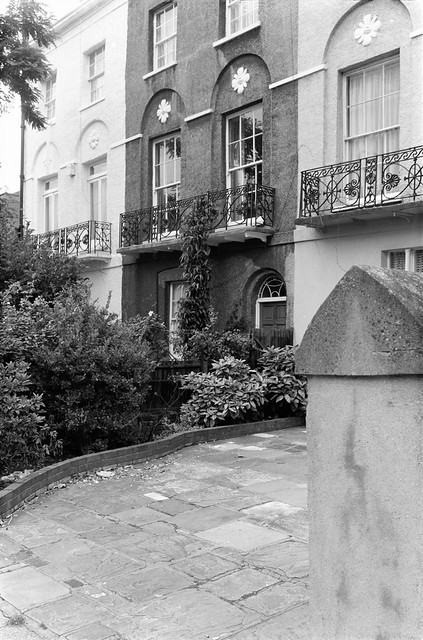
Abercorn Place, St John’s Wood, Westminster, 1988 88-7e-11
This small group of three houses on Abercorn Place at the corner of Violet Hill stood out among the fairly varied architecture of the street for the flower motifs above their first floor windows – a reminder, like the name Violet Hill, that this was the first garden suburb.
The gateposts, one of which is at right of the picture I think used to have a more obvious pattern on them, unfortunately out of focus in my image, which made them appear less crude.
My wanderings around St John’s Wood on a Saturday in July 1988 will continue in a later post. You can click on any of the pictures here to go to a larger version in my album 1988 London Photos, from where you can browse the album.
Hilgrove Rd, South Hampstead, Camden, 1988 88-6d-12
This semi-detached pair of Gothic revival red brick house date from around 1870 and are locally listed. They have a very ecclesiastical look. Hilgrove Road was laid out as Adelaide Road North in the 1830s or 40s and named in honour of Queen Adelaide, born as Adelaide of Saxe-Meiningen in 1792 who in 1818 was married to William, Duke of Clarence and became Queen who in 1830 became queen consort of Great Britain when her husband was crowned as William IV.
The road was renamed Hilgrove road in 1875 by developers who wanted to attract house buyers with a name that suggested it was a semi-rural location – something that is very common in this area. You can read more about Camden street names in a listing by David A. Hayes and Camden History Society.
Fairhazel Gardens, South Hampstead, Camden, 1988 88-6d-13
Fairhazel Gardens sounds like another of these ‘semi-rural’ estate agents names, but apparently was taken from a truly rural local property on the Sussex estate of the Maryon Wilson family. Sir Thomas Maryon Wilson (1800 – 1869) was the 8th Baronet of Eastbourne and Charlton. He was also lord of the manor of Hampstead and according to Wikipedia tried hard to cover the area with housing despite problems with the terms of his fathers will and the protests of local residents. You can read more in the Oxford Dictionary of National Biography.
Fairhazel Gardens (originally called North End Road) began to be developed in 1879 but the flats probably date from between 1886 and 1896. The area was developed by Sir Spencer Maryon Wilson, the tenth baronet (1829–1897).
Greencroft Gardens, South Hampstead, Camden, 1988 88-6d-14
Greencroft was another genuinely rural name, coming from a farm near near Great Canfield on the Essex estate of the Maryon Wilsons (again according to the Camden History Society listing.) The houses here were built by Ernest Estcourt and James Dixon in the late 1880s.
Canfield Gardens, South Hampstead, Camden, 1988 88-6e-62
Great Canfield on the Maryon Wilson Essex estate gave its name to Canfield Gardens – the estate there also contained a 16th century mansion Fitzjohns whose name also appears in the Hampstead area.
Cleve Rd, South Hampstead, Camden, 1988 88-6e-63
Woodcote at 16 Cleve Rd, the road named after a property near Quex Park in Birchington-on-Sea, Kent, the home of the Powell Cotton family who developed their estate around Quex Rd from 1868 on, with Cleve Road coming in 1882-6. Woodcote is a village on the Chilterns in South Oxfordshire, not far from Goring. Woodcote House there was the home of the Cotton family from around the 1790s until some time in the following century.
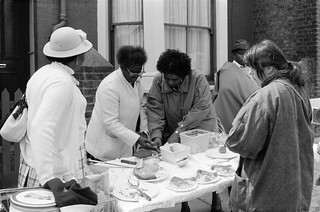
Kingsgate Rd, Kilburn, Camden, 1988 88-6e-51
Walking back towards Kilburn Park station my usual wandering fashion I came across this food stall being prepared in Kingsgate Road, though I can no longer remember what was the occasion for it. It looks like some church group, perhaps from the church close to the Quex Road end of Kingsgate Rd.
Belsize Rd, South Hampstead, Camden, 1988 88-6e-52
This long parade of shops is still there to the west of the junction with Kilburn Priory at 199-219 Belsize Rd. Belsize Rd was developed from 1851.
221 Belsize Rd, South Hampstead, Camden, 1988 88-6e-53
Kilburn High Rd, Kilburn, Camden, 1988 88-6e-54
The Red Lion at 34 Kilburn High Rd claims to have been established in 1444 and rebuilt in 1890, then replacing a rather charming two storey building possibly a hundred years old. At some time after my photograph it became called The Westbury, then in 2012 a bar called Love and Liquor, and finally in 2017 Soul Store West, a dinner, cocktail bar and hotel, which closed after four months. You can read more on its history in ‘Professor Morris’ and the Red Lion, Kilburn. The authors of this say the earliest date they can trace for the pub is an alcohol licence for 1721.
Tin Tabernacle, Cambridge Ave, Kilburn, Brent, 1988 88-6e-55
Finally as I walked towards Kilburn Park Station I couldn’t resist taking another picture of TS Leicester, Kiburn’s ‘Tin Tabernacle’.
This was my final picture in London for around a month, though I made more pictures of Hull and also on an industrial architecture visit to Sharpness and the Forest of Dean.
Rowley Way, South Hampstead, Camden, 1988 88-6d-54
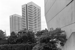
Camden council bought the Alexandra Road estate, part of the Eyre estate in North London and their architect Neave Browne designed this ziggurat style terrace in 1968, but construction only began in 1972. Browne saw the design, with vehicles restricted to the basement level as a better solution than tower blocks, which had been discredited by the Ronan point collapse and other problems. Family flats with small gardens opened onto the walkway at ground level, with smaller flats stepped back above them, so all got good light and air. The height of the 8 storey block at left gave some protection to the rest of the estate from the noise of the main West Coast railway line from Euston.
I had wrongly titled this Langtry Walk, which runs at the south of this estate a few yards away with a single lower row of flats by Browne built on similar principles. The name Langtry walk refers to royal mistress Lily Langtree, nicknamed “The Jersey Lily”, who, as local historians Dick Weindling and Marianne Colloms have shown had no connection with the area but was co-opted by a resident whose house in Alexandra Road was to be demolished for the new estate.
The estate was Grade II* listed in 1993, remarkably early in its life and the first post-Second World War council estate and one of very few public housing schemes to acheive this status.
This photograph was made from Abbey Road, with the back of Rowley Way at the right of the picture. Snowman House at left is on Abbey Road and Casterbridge at the corner of this and Belsize Rd and both are in Camden Council’s Abbey Estate. Both were approved in 1965 and building completed in 1967. They have 20 storeys above ground and are 59.4m tall – about 195 feet.
A bridge across Abbey Road connects the Casterbridge tower with another Abbey estate building, Emminster, which has a parade of shops at ground level. Both the 8 storey Emminster and another block, Hinstock, are scheduled for demolition to make way for new affordable homes to be built, and improvements to the road layout. This bridge was still there in April 2021, but will presumably soon be gone.
Finchley Rd, Camden, 1988 88-6d-35
I walked back towards Kilburn Grange Park and then to West End Lane, and then across to FInchley Road. On my contact sheet this row of heraldic figures on the front garden wall of a house is labelled ‘Finchley Rod’, but it may have been a few yards down a side turning.
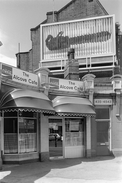
The Alcove Cafe, Finchley Rd, Camden, 1988 88-6d-36
The Alcove Cafe was in a part of the former station entrance for the Finchley Road (Midland) station which first opened as Finchley Rd & St John’s Wood in 1868. Around 1905 a row of seven shops and offices named Midland Crescent was added to the entrance on the west side of FInchley Road. The station closed in 1927 but the shops remained, being demolished in the early 1990s for the building of the O2 Centre here. Various planning, finanacial and other problems held up the new building which finally opened in 1998.
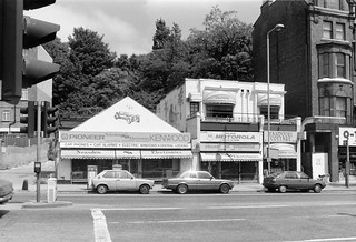
Neasden Electronics was roughly opposite the former station, and these buildings have now been replaced by a hotel.
Broadhurst Gardens, South Hampstead, Camden, 1988 88-6d-22
I walked down towards Swiss Cottage turning briefly into Broadhurst Gardens to make a picture of the rear of the St John’s Court flats on FInchley Rd, built in 1937-8, architect T P Bennett, with the lower three floors for the department store John Barnes, with five floors above housing 96 flats. In 1940 the store became part of the John Lewis Partnership. It closed as a department store in 1981 and the ground floor are now occupied by Waitrose.
Swiss Cottage, South Hampstead, Camden, 1988 88-6d-24
I made a couple of photographs of new office buildings at Swiss Cottage.
Swiss Cottage, South Hampstead, Camden, 1988 88-6d-25
And then went on the photograph Ye Olde Swiss Cottage, a Grade II listed Samuel Smiths pub originally built as an alpine-style chalet and called The Swiss Tavern.
Ye Olde Swiss Cottage, Finchley Rd, Camden, 1988 88-6d-26
Various dates for the building of the chalet can be found on the web, including both 1804 and 1840. Possibly CAMRA may be more reliable given the nature of the building, which they state “was built in 1830 by T Redmond and it stood next to a toll gate; travellers would stop at the tavern while waiting to pay their fees. There had been a gabled building on the site called Lausanne Cottage said to have been used by Charles II as a hunting lodge and their may have been an earlier pub called the Swiss Tavern.”
I didn’t pop in for a pint of ‘Old Brewery Bitter’ (and probably it wasn’t then on tap) but continued my walk – and will do so in a later post.
Click on any of the pictures to go to a larger version on the album 1988 London Photos from where you can browse the whole album. Pictures there are usually in file name order which differs from the order in which they were taken.
St Lawrence Mansions, Priory Park Rd, Kilburn, Brent, 1998 88-6d-03
I continued my walk along Kilburn High Road, photographing again some of the buildings I had photographed on my previous walk in Kilburn, and going down Priory Park Road to take a couple of pictures of St Lawrence Mansions, Victorian flats. These were used for some years by Brent Council to house homeless families, and applications by the owners to demolish them were turned down in 2012. In 2017 they were in used to house over 200 asylum seekers in desperately poor and overcrowded conditions in a hostel run by run by Clearsprings Ready Homes, a company that has been criticised in media reports about this and other asylum hostels.
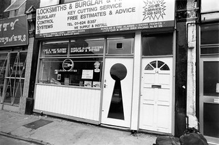
I’ve always been interested in trade signs and liked the large keyhole of this locksmith’s,on Willesden Lane, close to its junction with Kilburn High Rd.
Willesden Lane, Kilburn High Rd, Kilburn, Brent, 1998 88-6d-62-positive_2400
Taken just a few yards closer to Kilburn High Rd, with Kilburn State Cinema tower visible. The large sign for Brondesbury Garage above Brondesbury Mews entrance has now gone, the Gentlemen’s convenience has disappeared, the billboards have gone and Biddy Mulligans is now a betting shop, but the view is still much the same.
Kilburn State, cinema, Kilburn High Rd, Kilburn, Brent, 1998 88-6d-63
Grade II* listing has protected the Gaumont State Theatre, a splendid art deco building withh opened in 1937, seating over 4,000. Since 2007 it has been a church and still contains one of the largest fully functioning Wurlitzer organs in Britain.
The National Club, Kilburn High Rd, Camden, 1998 88-6d-65
The National Club is another building I’ve previously photographed and written about in my postTo Kilburn High Rd 1988 – and like the Kilburn State is now also a church. The boundary between Brent and Camden runs down the Kilburn High Road, with properties on the east side being in the LB Camden.
Wallace Manufacturing Chemists Ltd is still active according to Companies House, but no longer in Netherwood St. Its business is described as ‘Manufacture of basic pharmaceutical products’ with a registered office in Brentwood and I think is now a part of the Alinter Group based in Abingdon. Perhaps the graffitied ‘INFECTION’ was a mildly humourous comment on the closure of the premises making medicines – Histergan cream and tablets, Ironorm drops and Malarivon and Vigranon-B syrups.
Quex Rd, Kilburn, Camden, 1988 88-6d-45
These pictures show the doorway at 15 Quex Rd, on the corner with Mazenod Avenue, part of a set of mansions at 9-15 Quex Rd, just a few yards from Kilburn High Rd. I’ve called it Kilburn, but certainly for estate agents this is West Hampstead.
The road was built on a large estate on both sides of West End Lane which had been inherited in 1813 by John Powell Roberts following the death of his brother who fell from a horse. His brother had previously inherited this and a large house a Quex Park in Birchington, Kent under a trust following the death of his uncle, and the terms of that trust meant changing his surname to Powell, and John Powell Roberts became John Powell Powell. When he died in 1849 the various estates held by the trust passed to his nephew, Col Henry Perry Cotton.
Quex Road, named after the Powell-Cotton family seat, was at the heart of plans for the development of the estate made in 1866, which included a Roman Catholic church and Wesleyan Methodist and Unitarian chapels on Quex Rd built in 1868-9 and the street was more or less fully developed by 1885.
Eugene de Mazenod was a leading French Catholic bishop in the nineteenth century and founder of the Oblates of Mary Immaculate who became missionaries across the world and founded the Church of the Sacred Heart of Jesus in Kilburn in 1866, though their temporary building was replaced by one designed by E W Pugin and built after his death from 1875-1899.
Quex Rd, Kilburn, Camden, 1988 88-6d-45
Click on any image to go to a larger version in my album 1988 London Photos from where you can browse the other images in the album.
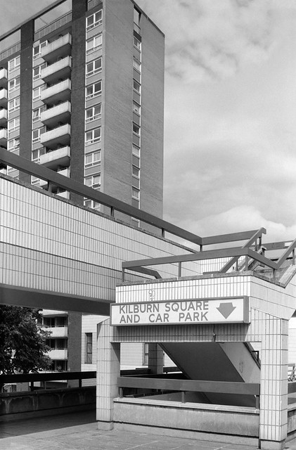
My next visit to Kilburn came in June 1988 and I began my walk from Kilburn Park station on the Bakerloo line. I took a couple of pictures in Cambridge Ave, but nothing exciting and then walked up Kilburn High Road to Kilburn Square.
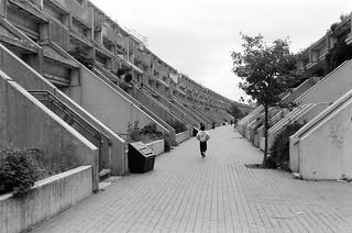
Kilburn Square was built in the 1960s for Willesden Municipal Borough Council with a 17 storey high rise with 85 flats and four low rise blocks with a shopping centre and market area in a wide pavement in front of them on Kilburn High Rd. Work began on the tower block in 1961. The estate replaced Victorian terraced houses in the square.
These pictures are from the front block of the estate, the shops fronting Kilburn High Rd. It was designed to have shops on the first floor, but these were never very successful. They could be reached by steps or a long slope. This shows the tower on the estate behind the shops.
The management of the estate behind the shops passed to a Tenant Management Organisation in 1994 following the Right to Manage Legislation. Currently Brent Council is still consulting on plans to add infill housing to the estate, and appears to be taking some of the residents views into consideration. Although it’s sad to lose green space, if infill is done sensitively its better than the comprehensive demoltion of many estates across London which always result in a loss of social housing.
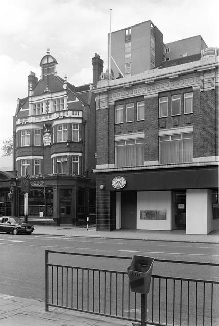
The Cock Tavern, Kilburn High Rd, Kilburn, Brent, 1988 88-6c-11
The Cock Tavern at 125 Kilburn High Road has a plaque stating it was licenced in 1486 and rebuilt in 1900 and was a Truman pub. It was later owned by Greene King and from 2009-11 was also home to a theatre on the first floor, but this had to close as the staircase was found to be unsafe. It was sold in 2016 and closed in 2019, reopening in January 2020 as The Juniper. The building is locally listed by Brent Council.
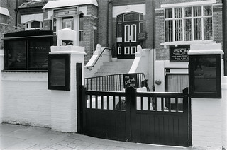
Quex Rd, Camden, 1988 88-6c-13-positive_2400
This estate office in Quex Road appeared have something of an obstacle course to enter, apparently designed to eliminate access for any disabled clients. I think there was probably a slope down behind the front gates then two sets of steps to the entrance.
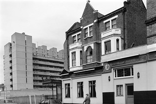
The Earl Derby, Priory Park Rd, Kilburn, Brent, 1988 88-6c-15
The Earl of Derby dates from around 1869 at 155 Kilburn High Road. Having been called the Golden Egg for some years it reopened in 2013 and was described as a gastro pub under a shorter version of its original name, simply Earl Derby. It claims to be home to the cheapest pint in London, and in 2020 some beers were £2.00 a pint.
The side of the pub shown is on Priory Park Rd, and the block further down the road is Ryde House, designed by Willesden Borough Council Architect’s Department and built in 1964.
Sadly the wrought iron entrance at the left of the pub has been lost in alterations to the side of the pub. I hope it has been preserved somewhere.
Click on any image to go to a larger version in my album 1988 London Photos from where you can browse the other images in the album.
My next walk at the end of May 1988 took me to Kilburn Park and Kilburn, and again in this post I have put the pictures in the order of my walk rather than the somewhat random order they have in the Flickr album 1988 London Photos. The church in the picture of Carlton Vale is St Augustine, Kilburn, and the large block of flats on the corner of Carlton Vale and Kilburn Park Rd was demolished in 2018-9, though I think the overhead walkway went many years earlier.
Kilburn, Brent 1988 88-5k-15
These lower blocks of flats were a part of the same South Kilburn estate and I think close to the corner of Carlton Vale and Cambridge Rd. The estate of high-density housing in low-rise flats and 11 tower blocks was begun in 1959 and further developed in the 1960s and 70s. Brent embarked on a comprehensive redevelopment in 2014, which is resulting in a considerable loss of social housing.
Oxford Rd, Kilburn, Brent, 1988 88-5l-61
Unsurprisingly Oxford Road runs parallel with Cambridge Ave up to the Kilburn High Rd. These streets were two of those developed by local builder James Bailey in the 1860s, developing the area he called Kilburn Park. The name was given to the first underground station in Kilburn which opened in 1915 in Cambridge Ave.
Oxford Rd, Kilburn, Brent, 1988 88-5l-64
These are typical houses of the era and were probably built from published designs in architectural pattern books. My grandather, who built a few houses on a much less grand scale had owned at least one of these and as children we were sometimes allowed to look at this beautifully illustrated volume.
Cambridge Avenue, Kilburn, Brent, 1988 88-5l-66
At its southern end Cambridge Avenue leads to both Cambridge Road and the rather posher Cambridge Gardens.
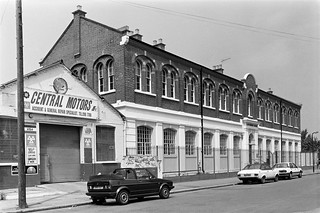
Central Motors, Canterbury House, Canterbury Rd, Kilburn, Brent 1988 88-5l-52-positive_2400
Central Motors in Canterbury Rd still looks much the same, but Canterbury House, although retaining the facade had two extra storeys added in 2015-6 with luxury flats and penthouses. It as built in 1862 when this was still a part of Kilburn Lane as a railway signal factory for Saxby & Farmer who became one of the largest employers in the area but moved out around 1906.
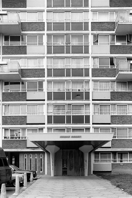
Crone Court, South Kilburn Estate, Rupert Road, Brent, 1988 88-5l-53
Crone Court is on the corner of Rupert Rd and Denmark Rd on the South Kilburn Estate and is due for redevelopment in the next few years. The 12 storey block, 32m tall, was completed in 1964.
Joe’s Used Ballbearing Emporium, Malvern Rd, West Kilburn, Westminster, 1988 88-5l-55
Joe’s Used Ballbearing Emporium & Cycleworks was definitely in Malvern Rd, West Kilburn as it had a street sign higher up on the building. It had a remarkable window display and I took far too many pictures – a few of them here.
Joe’s Used Ballbearing Emporium, Malvern Rd, West Kilburn, Westminster, 1988 88-5l-56
Joe’s Used Ballbearing Emporium, Malvern Rd, West Kilburn, Westminster, 1988 88-5l-41
Joe’s Used Ballbearing Emporium, Malvern Rd, West Kilburn, Westminster, 1988 88-5l-45
Joe’s Used Ballbearing Emporium, Malvern Rd, West Kilburn, Westminster, 1988 88-5l-31
Click on any of the images to go to a larger version in my album 1988 London Photos from where you can browse the rest of the album.
London House, Fulham Rd, Chelsea, Kensington and Chelsea, 1988 88-5c-45
My walk around the streets to the north of the King’s Road took me as far as the Fulham Road where I found London House at No 266 and joined to it a Servite Catholic Church. Our Lady of Dolours was started by two Servite priests, missionaries from Florence who arrived in London in 1864. Building the church here, designed by Joseph Hansom began in 1874 and it was opened the following year by Cardinal Manning. The church is Grade II listed. London House is currently being refurbished and extended, returning the exterior to something more similar to its Victorian original.
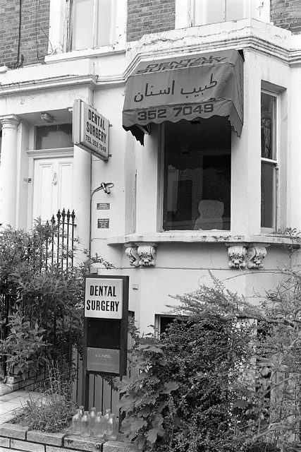
Kings Rd, Chelsea, Kensington and Chelsea, 1988 88-5c-44
V K Patel is still listed as having a dental surgery on the King’s Road, and, allowing for the various London number changes has retained the same phone number, but is now in a very different building to this rather run-down looking and overgrown house, which I think has probably been demolished.
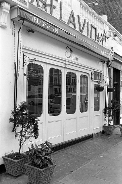
Langton St,, Chelsea, Kensington and Chelsea, 1988 88-5c-42
Flavio looks like an Italian restaurant and although my contact sheet suggests it was on the King’s Road, was actually a few yards from it in Langton St. I think it is now an Irish restaurant with a different shopfront.
Kings Rd area, Chelsea, Kensington and Chelsea, 1988 88-5c-54
I’m unable to remember where I took these two decorative bowls on window ledges, but think it might have been on Lamont Road or one of the adjoining roads.
Hobury St, Chelsea, Kensington and Chelsea, 1988 88-5c-56
31 Gertrude St is on the corner with Hobury St and the door is actually in the latter street. It retains the simple elegance that attracted me to photograph it back in 1988. Poet and novelist George Meredith (1828-1909) has a blue plaque on the next house down Hobury St. It was his poem ‘The Lark Ascending’ that inspired the well-known composition by Ralph Vaughan Williams and elsewhere Meredith was the first to publish the word ‘tweets’ as a verb, though his twittering was avian.
Kings Rd, Chelsea, Kensington and Chelsea, 1988 88-5c-52
Chamberlin, Powell & Bon designed 355 Kings R for Kensington and Chelsea council and this 15 storey 152 ft high tower was built in 1968-71. The council sold it off in the 1980s when the brickwork was begining to need repair and it was reclad and converted to private flats. At the right is an office of Roy Brooks, the estate agent who became a legend in the 1960s (he died in 1971) and made a fortune through his adverts in the Sunday Times and Observer desribed the houses he was selling in vivid terms as hardly fit for human habitation, exagerating any defects and making them up where none existed.
Lamont Road Passage, Park Walk, Chelsea, Kensington and Chelsea, 1988 88-5c-53
A handy passage for those living in Lamont Road to get to the shops in Park Walk and the King’s Road. The picture is of its corner with Park Walk and at left you can see Roy Brooks Estate Agents, a tree in the Milman’s Street Moravian Burial Ground and the house on the corner of Milmans St and the King’s Road. There is of course another tree in the shop window.
Clicking on any of the pictures will take you to a larger version in my album 1988 London Photos from where you can browse the other images in the album.
All photographs on this and my other sites, unless otherwise stated, are taken by and copyright of Peter Marshall, and are available for reproduction or can be bought as prints.
The Gateways, Sprimont Place, College Place, Chelsea, Kensington and Chelsea, 1988 88-5a-43
The Gateways is a block of houses with a difference and though it may look ancient, was built in 1934 in a Tudor Revival style to designs by Herbert Winkler Wills (1864-1937) and William Kaula. Certainly unusual but not greatly to my liking the whole block was Grade II listed in 1993, some under the address Whitehead’s Grove.
Chelsea Green, Chelsea, Kensington and Chelsea, 1988 88-5a-45
All that remains of the old Chelsea Common is a small triangle at this road junction with two small fenced plots of grass, each with a small tree, separated by a footpath through its centre, room on both sides for a couple of park benches and a rubbish bin or two.
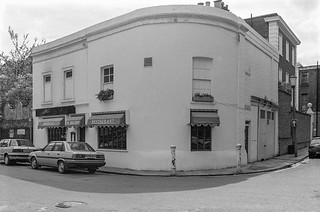
Chelsea Green, Chelsea, Kensington and Chelsea, 1988 88-5a-46
Stepping a few feet gave a clearer view of the pub, still now open but called The Wild Tavern, and the buildings down Elystan Place which are a part of The Gateways, with some good brickwork.
Bray Place, Draycott Ave, Chelsea, Kensington and Chelsea, 1988
The ornate ironwork around and in the door of 5 Bray Place finds an echo in the window opposite. This doorway has now been converted into a rather plain window and there are other changes to the exterior of the building. It remains a restaurant but with a different name under different management.
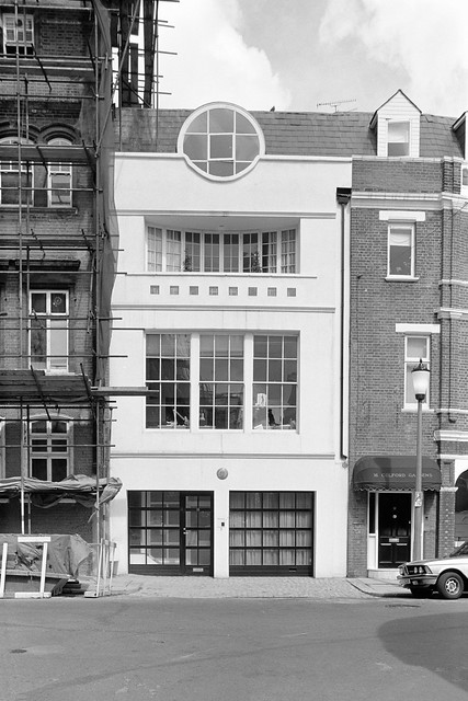
Blacklands Terrace, Chelsea, Kensington and Chelsea, 1988 88-5a-52
This building is on Blacklands Terrace, but confusingly has the address 18 Culford Gardens, which it and the building to its right stand on the corner of. I don’t know when it was built – or perhaps when this frontage was added, but it was very different from the properties around. The ground floor has since been altered and is now less starkly geometrical.
Avenue Court, Draycott Avenue, Knightsbridge, Kensington and Chelsea, 1988 88-5a-61
Draycott Avenue is lined with large and rather boring appartment blocks, mainly in red brick, which are slightly enlivened by some impressive doorways – and I think this is the most impressive. Most of these large blocks of flats were built in the 1930s, replacing streets of smaller houses. In Pevsner’s The Buildings of England London NW it describes them as “enormous and forbidding blocks of flats, either cautiously Art Deco or approximately neoGeorgian in style.”
Avenue Court, Draycott Avenue, Knightsbridge, Kensington and Chelsea, 1988 88-5a-01
Sloane Avenue Mansions also dates from the 1930s, redeveloping an area of smaller houses but was designed by G. Kay Green in a more modern style with touches of Art Deco. Built in 1931-3, it towers 11 stories above the street, though appears slightly less massive as the top two are set back slightly. Around 20,000 working class people had lived in homes around here that were cleared after the company decided to redevelop the area in 1908, though much of the area remained empty or full of part-demolished slums until the 1930s. The large blocks of flats were usually provided with underground garages for the wealthy flat-dweller.
Click on any of the images to go to a larger version in my album 1988 London Photos, where you can browse through the rest of the images in the album.
All photographs on this and my other sites, unless otherwise stated, are taken by and copyright of Peter Marshall, and are available for reproduction or can be bought as prints.
A GLC plaque records that Admiral of the Fleet Earl Jellicoe (1859-1935) lived in this house.
Blacklands Lane ran from the Kings Road to Fulham Road; most was renamed Marlborough Road in the 1820s and later became Draycott Avenue. The name Blacklands possibly came from the dark earth of Chelsea Common and was a small hamlet and a large house dating at least from the 1680s which at the start of the 18th century was a French boarding school for young ladies and became an asylum for the insane in the 19th century and Samuel Wesley spent some time as a patient there in 1808. Blacklands Terrace was developed at the end of the 19th century taking its name from the house a short distance to the west and was on a part of its extensive estate There was also a house nearby called Whitelands, which became a paper factory. The short street is now best known for a restaurant (an earlier version was a location in Blowup) and a independent bookshop opened by John Sandoe in 1957.
Both the outside of Andrea’s Restaurant and the interior feature in the film ‘Blowup’ made in 1966 and its exterior had changed little 22 years later. After than it became El Blason Restaurant & Tapas Bar and then in 2013 went considerably upmarket as The Five Fields with a Michelin star and prices to match.
This huge block of flats in Brompton is the rear of Chelsea Cloisters, ten storeys with over 800 small flats as well as shops etc along its Sloane Avenue frontage, built in the 1930s, demolishing the earlier houses on the site. The block was controversially bought in 1968 by the Freshwater Corporation. The conversion of part of the property into a hotel was extremely controversial, and many tenants lost their homes. Plans by the GLC and Kensington & Chelsea council to buy the block for public housing fell through and in 1984 the 747 flats, garage, petrol-filling station, restaurant, and coffee shop were sold. It was then extensively refurbished. (British History Online.)
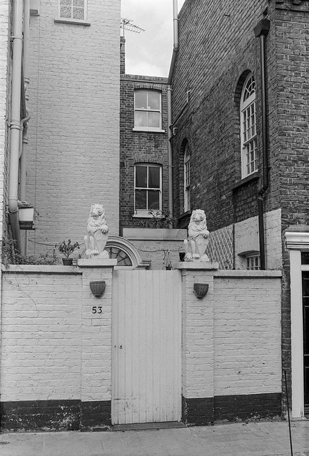
The entrance into a small private courtyard in front of 53 Bury Walk still has this pair of lions proudly guarding a rather plain and basic gate. The street perhaps gets its name (previously Bury Street) as it led to St Lukes Burial Ground. It was developed on Chelsea Common in the nineteenth century.
These flats are I think Thurloe Court which consists of two linked blocks, that at right with a frontage on the Fulham Road, or possibly a neighbouring 1930s block of flats, and I walked down the narrow Kinbolton Way to take this picture bwtween the blocks. An estate agent describes it as a “charming, period, redbrick portered mansion block ideally situated between South Kensington, Knightsbridge and Sloane Square” and flats there are valued at £1.5-£2m.
The Baby Doll poster is for the 1956 American dramatic black comedy film directed by Elia Kazan. I think the shop is probably in Crescent Mansions at 113 Fulham Road. Steps led down to a basement where men’s clothes were for sale.
Pelham Crescent, South Kensington, Kensington & Chelsea, 1988 88-4r-45
Pelham Crescent was named after Henry Thomas Pelham, third Earl of Chichester, one of the trustees of the Smith’s Charity which acquired the land from nurserymen Samuel Harrison and William Bristow who went bankrupt in 1832. George Basevi junior provided the drawings for the house frontages which were contracted to builder James Bonnin who was required to build houses worth at least £800 and complete the job in seven years. (British History Online.) They now sell for over £10m.
Click on any of the images to see a larger version in my album 1988 London Photos and to browse the images there.
All photographs on this and my other sites, unless otherwise stated, are taken by and copyright of Peter Marshall, and are available for reproduction or can be bought as prints.