Loughborough Estate, Angell Town & a Garage – 1989

The fourth post on my walk in Kennington and Brixton on Sunday 6th May 1989. The posts began with Hanover, Belgrave, Chapel, Shops, Taxis. The previous post was Brixton Road and Angell Town -1989

Loughborough Estate, Flats, Loughborough Rd, Brixton, Lambeth, 1989 89-5d-44

I’m not sure which of the nine eleven-story slab blocks on the estate is shown in my picture; the estate was and remains a rather confusing area. Possibly this is Leicester House on Loughborough Road, or more likely Harpur House on Angell Road where I think I walked to next, but the lower buildings in front of the block appear to have gone.

The sign ‘NO HATS’ is not a reference to any headgear but to Housing Action Trusts, an important part of Margaret Thatcher’s marginalisation of local authorities. Having ochestrated the run-down of council estates by earlier restrictions on council spending and the right to buy schemes, the Housing Act 1988 aimed to transfer these estates to non-departmental public bodies which were to redevelop or renovate them so they could be transferred into private ownership.

Opposition to HATs was intense, with the Labour Part, local authorities and estate residents all fighting their imposition, and the first six areas intended to becom HATs managed to avoid implementation, though later six were formed, but none in south London.

Lunch Club, Loughborough Estate, Angell Rd, Brixton, Lambeth, 1989 89-5d-45

I think this rather temporary-looking building as on Angell Road close to Harpur House, but no sign of it remains. I photographed it largely for the posters showing opposition to Housing Action Trusts in Broxton.

As well as a Luncheon Club for pensioners it also has a sign for the Loughborough Sports & Social Club.

Fence, St John the Evangelist, Angell Park Gardens Angell Town, Lambeth, 1989 89-5d-32
Fence, St John the Evangelist, Angell Park Gardens, Angell Town, Lambeth, 1989 89-5d-32

Further along Angell Road – named like the area after the Angell family who had owned large parts of the Lambeth and developed this area in the 1850s. In 1852 Benedict John Angell gave a site here for the building of St John the Evangelist Church which was consecrated in 1853. Unfortunately trees along the edge of the site along Angell Road and Angell Park Gardens had too many leaves in May to clearly see the church.

These paintings on the fence around the church are still visible but rather faded. I took a few pictures of them both in black and white and in colour before walking on past the church and across Wiltshire Road into Villa Road and back onto Brixton Road, where I photographed the rather austere Our Lady of the Rosary Catholic Church (not yet digitised.)

Abeng Youth Community Centre, Gresham Rd, Brixton, Lambeth, 1989 89-5d-22

I walked on down Brixton Road to the Police Station where I turned back east along Gresham Road, stopping to photograph what looked to me to be a former chapel. In 1877 this was the Angell Town Institution and later became Brixtons first telephone exchange.

In the 1970s the Rev Tony Ottey founded the Abeng Centre here to provide supplementary education and youth services to the local children. In 2003 it was relaunched with new management as the Karibu Centre, its Swahili name Karibu meaning welcome, with similar aims. It is also hired for weddings, funerals, birthdays and business meetings.

Wyck Gardens, Loughborough Estate, Millbrook Rd, Brixton, Lambeth, 1989 89-5d-24

Soon I was walking through the Loughborough Estate again, going along Millbrook Road and through Wyck Gardens, a public open space which is thought to be the remnant of a larger wood knwon as Wickwood in the Manor of Lambeth Wick which had been cleared by the end of the 17th century.

The land had belonged to the Archbishops of Canterbury and was bought by the London County Council from the Church Commissioners for a new public open space, opened in 1959 and since extended and improved. You can see more pictures from the park on Brixton Buzz.

I think the large block here is Barrington Court, the first of three I walked past on my way through the park towards Loughborough Junction.

Garage, Railway Arch, Ridgway Rd, Loughborough Jct, Lambeth, 1989 89-5d-25

I left the park and walked along Ridgeway Rd, beside the railway line from Brixton which curves around to a junction just north of Loughborough Junction Station. The next station on this line is at Elephant & Castle.

Some extensive work seems to be in progress on what I am reliably informed (thanks to comments on Flickr) is a Ford Escort, while inside the garage a Renault 4 and a Rover P5 await their turn.

Arch 500 was empty for some years but later became home to the very Brixton Buzwakk Records Recording Studio a few years ago. The arches on both sides are still garages.

More about this walk in May 1989 in a later post.


Brixton Road and Angell Town -1989

The third post on my walk in Kennington and Brixton on Sunday 6th May 1989. The posts began with Hanover, Belgrave, Chapel, Shops, Taxis. The previous post was On the Road to Brixton.

House, Brixton Rd, Brixton, Lambeth, 1989 89-5d-62

No 326, with two doors above each other with steps to the upper door with a balustrade. Many of the houses along here date from the first development along the road and are good examples of early-mid 19th century houses and most have some intresting features but are perhaps not distinctive enough to deserve listing.

The house now looks much the same as when I photographed it. I suspect this unusual arrangement with steps up to the front door was how this house was built. While many houses from the period have basement flats, this appears to have been built with its ground floor rather higher, perhaps becuase of the risk of flooding from the River Effra. But if so, why was a similar approach not used for neighbouring houses?

J & P Motors, Thornton St, Stockwell, Lambeth, 1989 89-5d-63

I walked a little back up Brixton Road to Thornton Street, though too much has changed for me to positively identify the exact location of J & P Motors on this fairly short L-shaped street. I think it was probably on the north side of the bottom of the L behind what is now the worker’s co-operative, Brixton Cycles.

There was a splendid utilitarian simplicity of this building which appealed to me, and which I enhanced with its symmetrical gates and No parking signs.

Evereds, Brixton Rd, Brixton, Lambeth, 1989 89-5d-66

Back on Brixton Road, Evereds Bathrooms had its showroom in two shops at 308-10 Brixton Rd. The buildings here are still standing but no longer in use as a shop. For some years since 2011 the Victorian shopfront built as a house agents in 1879 has been in use as an art gallery, SHARP Gallery (Social, Hope and Recovery Project) which has shown the work of over 120 artists, many of whom use mental health services and is supported by the South London and Maudsley NHS Trust. Both the early nineteent century house and these shops are Grade II listed, along with 312.

Eagle Printing Works, Brixton Rd, Brixton, Lambeth, 1989 89-5d-51

Both buildings at 304 and 306 Brixton Road have survived, but in 2013 planning permission was granted for changes to the Eagle Printing Works, and the fine semi-circular panel including the building date of 1864 and its wrought-iron decoration was removed – a piece of vandalism that should never have been approved.

Apparently the printing works a few years later became a sub district Post, Money Order and Telegraph Office, and it was from here that Sherlock Holmes sent his first telegram.

Loughborough Hotel, Evandale Rd, Brixton, Lambeth, 1989 89-5d-52

I turned off the Brixton Road where I had spent some time wandering back and forth and struck off to the east along Loughborough Road. The first picture I took was of the Loughborough Hotel, described in more detail on a previous walk, a well known music venue, closed in 2008 and has been converted into flats, with a café gallery on the ground floor.

Lilford Rd, Minet Rd, Camberwell, Lambeth, 1989 89-5d-54

From Fiveways I continued along Lilford Road, again stopping to re-take the impressive porch on its corner with Minett Road, also featured in a previous post. I chose a very similar viewpoint but the lighting was quite different as it had been overcast for the earlier image.

I can’t remember why I made the detour, though possibly it was just the sheer pleasure of seeing an area with so many fine buildings again. Or it could have been to find a pleasant place to sit and eat my lunch, as I walked as far as Myatts Fields before returning to Loughborough Rd.

Elmore House, Loughborough Estate, Flats, Loughborough Rd, Brixton, Lambeth, 1989 89-5d-43

On Loughborough Road I was in a very different London, the Loughborough Estate, redeveloped after much of the area was devastated by wartime bombing. The first stages of the rebuild were in five-storey red brick blocks typical of 1930s LCC estates of that era, solid and with decent sized rooms but uninspiring visually. There height was kept to five floors as they had no lifts.

From 1954-7 more of the estate was developed with a mix of high and low-rise modern buildings designed by the LCC Architects Department which included nine eleven-storey slab blocks which became a model for later LCC estates. They even gained approval from John Betjeman who Layers of London quotes as writing “When one compares their open-ness, lightness, grass and trees, and carefully related changes of scale from tall blocks to small blocks, with the prison-like courts of artisans’ dwellings of earlier ages, one realises some things are better than they were… Maybe it has no place for someone like me, but it gives one hope for modern architecture.”

Not everyone shared Betjeman’s enthusiasm, and by the time I made these pictures the area had gained a reputation for crime, one of a number of estates in London about which some people expressed shock that I was walking around taking pictures. More about my walk in a later post.


On the Road to Brixton

On the Road to Brixton is the second post on my walk in Kennington and Brixton on Sunday 6th May 1889. The posts began with Hanover, Belgrave, Chapel, Shops, Taxis.

Christ Church, Brixton Rd,  Kennington, Lambeth, 1989 89-5c-31
Christ Church, Brixton Rd, Kennington, Lambeth, 1989 89-5c-31

This remarkable Grade II* listed building in a composite of Art Nouveau and Byzantine Revival style was designed by Arthur Beresford Pite who was the brother-in-law of the then vicar, Rev William Mowll, whose name is on the adjoining street. It was completed in 1907, though the design dates from the 1890s and the foundation stone was laid in 1898 and the building consecrated in 1902.

It remains in use as an Anglican Church. Some describe it as an architectural monstrosity, but although I think it has a rather split personality it has an overwhelming impact.

Christ Church, Brixton Rd,  Kennington, Lambeth, 1989 89-5c-33
Christ Church, Brixton Rd, Kennington, Lambeth, 1989 89-5c-33

The church was built on the site of an earlier chapel, Holland Chapel, built as an Independent Chapel around 1823 and sold to the Church of England around 1835 and renamed Christ Church. This was a simpler building with a central bell turret but of some size, seating around a thousand and was demolished in 1899, with worship continuing in a hall behind while the new church was being built.

The Holland Chapel had no graveyard and Christ Church was at first only a chapel in the parish of St Mark’s Kennington where burials took place. Before 1825 all this area was in the parish of St Mary Lambeth, now the Garden Museum next to Lambeth Palace. Christ Church became a parish church in 1856.

Christ Church, Brixton Rd,  Kennington, Lambeth, 1989 89-5c-21
Christ Church, Brixton Rd, Kennington, Lambeth, 1989 89-5c-21

The building is often open to the public over the centre of the day and the stained glass is said to be spectacular. The interior (which I’ve not photographed) has more of an Art Nouveau feel than the exterior. The building has been considerably altered since 1907. It was built to seat 1,200.

You can just about see one of the many unusual features of the church at the extreme left of the picture, where there is a bell-shaped roof over an external pulpit, added to the building in 1907 at the insistence of the vicar.

Terrace, Brixton Rd,  Kennington, Lambeth, 1989 89-5c-24
Terrace, Brixton Rd, Kennington, Lambeth, 1989 89-5c-24

This terrace is opposite Christ Church and runs from 91 to 115 and was built at Bowhill Terrace. Some of the houses are stuccoed like these with others left as plain brick. I chose this pair partly for the bark of the tree at left, but also because of the different treatment of the two doors at the top of the steps leading up to both. I think the steps and their railings are probably a modern replacement.

Many of the houses along Brixton Road were in poor condition in the 1970s and were refurbished by the Greater London Council, mostly becoming social housing

Brixton Road was a Roman Road leading down to the south coast and was at one time known as ‘The way to Brighthelmstone’. Among other former names was Brixton Causeway, an embanked roadway running along the west bank of the ,. That it was also known as ‘The Washway’ perhaps suggests that it was sometime flooded by the river. The river was lowered and built over in 1880, becoming a sewer below the street and the earth extracted used to provide banking at the nearby cricket ground, The Oval.

Modern development beside the road only gathered pace after the building of Vauxhall Bridge in 1816 and acts of parliament for roads south from that meeting with Brixton Road at the Oval.

Between 1820 and 1824 the whole of the Manor was let to Henry Richard Vassall, third Baron Holland” and developed piecemeal by “builders and speculators” under building leases as brick houses “of at least the third rate“. According to the Survey of London, “This policy of piecemeal letting, especially in the Brixton Road, resulted in unrelated groups of villas and terrace houses which, in spite of the charm of individual members, gave to the whole an untidy and haphazard appearance.” For me it perhaps enhances the street with many of these varied Regency and early Victorian buildings remaining.

Brixton Rd, Brixton, Lambeth, 1989 89-5c-12

No 188 is a Grade II listed early mid C19 house. The listing text fails to indicate why this building, listed in 1981, has any particular architectural or historic interest. Originally this was one half of a pair of houses, the other half having been replaced by a dull 4 storey block of flats, Willow Court. Perhaps it was listed to save it from a similar fate.

Sheet Metal Works, Robsart St, Stockwell, Lambeth, 1989, 89-5c-13

I made a short detour from Brixton Road down Robsart St which leads west attracted by this three-story works just a few yards down on the north side.

The Brixton Sheet Metal Works building is still there at No 2, but considerably tidied and now Raw Material Music & Media Education who describe the building as a “purpose-built 3-storey building hosts 2 recording studios, computer suite, DJ, music and video production equipment and a live room for performance, workshops and ensemble work.”

It now has a red plaque with the message ‘This project is proudly funded by Comic Relief – All the silly nonsense of Red Nose Day is about the serious business of helping people change their lives – BILLY CONNOLLY 2003‘.

In 1919 No 2 Robsart St was occupied bys W Mason & Co. I think the building was possibly no longer in use in 1989, though there appears to still be a small shop at the left, firmly shut behind wire grilles in my picture.

This walk will continue in a later post.


Hanover, Belgrave, Chapel, Shops, Taxis

Hanover, Belgrave, Chapel, Shops, Taxis: Two days after my previous walk, on Sunday 6th May 1989 I was back on the streets with my cameras, this time getting off the bus at Oval station in Kennington.

Hanover Arms, House, Hanover Gardens, Kennington Park Rd, Kennington, Lambeth, 1989 89-5c-64

A few yards down Kennington Park Road from the Oval Station is Hanover Gardens, and on the corner the Hanover Arms. The pub has been here at least since the 1850s and is still open, getting rather more custom when there is cricket at the Oval a short walk away. Its Grade II listing calls the house ‘Early-mid C19’ but describes the ground floor pub as early C20. I’ve never been inside, but used to walk past it occasionally when a friend had a flat in Hanover Gardens in the 1970s.

The six monarchs of Britain from George I in 1714 to Victoria were known as Hanoverians, but after Queen Victoria married Prince Albert of Saxe-Coburg and Gotha they took over his family designation, changing the name to Windsor in 1917.

My interest was more in the splendid house of the same period on the opposite corner, 324 Kennington Park Rd. I don’t think this is listed, though much of Hanover Gardens is.

Hanover Arms, Belgrave Hospital for Children, Kennington Park Rd, Clapham Rd, Kennington, Lambeth, 1989 89-5c-52

Turning around from almost the same spot I made a photograph of the pub sign with its coat of arms and beyond, on the opposite side of the road, the fine Grade II* listed Belgrave Hospital for Children.

This voluntary hospital was founded in 1886 in Pimlico, and moved to this building in 1903, though the building, begun in 1899 was only completed in 1926. Part of the money for its building came in a donation by music hall star Dan Leno of £625 made after his last show and a few days before his death in 1904.

Belgrave Hospital for Children, Clapham Rd, Kennington, Lambeth, 1989 89-5c-53

The building is in red brick by Henry Percy Adams and Charles Holden and bears some resemblance to a Scottish castle. Its foundation stone was laid by the oddly named Princess Henry of Battenberg in June 1900. It became part of Kings College hospital on formation of the NHS in 1948 and closed in 1985. Left empty it was squatted for some time and then converted to expensive flats in the 1990s.

The building was designed in a roughly cruciform plan with separate ward wings that could be isolated in case of an outbreak of a highly infections disease.

Belgrave Hospital for Children, Clapham Rd, Kennington, Lambeth, 1989 89-5c-54

Kennington Park Road changes its name to Clapham Road at the junction just north of the hospital, something which has often confused me. The two previous pictures were taken from Kennington Park Road, but this was definitely made on Clapham Road.

The lettering in the sign ‘THE BELGRAVE HOSPITAL FOR CHILDREN SUPPORTED BY VOLUNTARY CONTRIBUTIONS’ has a playful Arts & Crafts font, very much of the time the building was commenced and perhaps more suitable for a children’s hospital than the more stern architecture

Claylands Road Chapel, Claylands Road, Kennington, Lambeth, 1989 89-5c-55

Claylands was a mansion built in the area of marshy land often flooded by the River Effra aournd 1800 by brick merchant John Fentiman who drained the land around. In 1836 he let his son, also John Fentiman, erect this excellent example of a Congregational Chapel on the corner of Claylands Raod and Claylands Place.

It prospered for some years and in 1899 a Sunday School was built behind it. Both went out of use, probably in the 1930s and were being used to store building materials when it was bought in the late 1960 by a firm of architect who restore it to use as their offices, renaming it ‘Old Church Court’.

Shop Window, Brixton Rd, Kennington, Lambeth, 1989 89-5c-42

I walked though from Clapham Rd to Brixton Road along Handforth Road, taking this picture of a shop window on Brixton Road. I was attracted by the clutter of tools and other objects, but also by two posters in the window.

One showed a dynamic young woman and was advertising dance workouts, but the other had the stark word ‘MURDER’, a poster from the Metropolitan Police asking for assistance in a recent murder outside a public house.

Works, Kennington Park Estate, Cranmer Rd, Kennington, Lambeth, 1989 89-5c-43

This 1906 factory building on the north side of Cranmer Road has since been converted as part of Kennington Park Business Centre with Salisbury House, Norfolk House, Worcester House and Winchester House.

The buildings on the northern part of this site were once the garage for London’s first motor taxi fleet, the General Cab Company Ltd, with 1,500 taxis based here, and I think these buildilngs may have been workshops for the company. Some time in the 1990s I took a very small part in the industrial archaeology recording of this site, but can’t find the details.

Shops, Brixton Rd,  Kennington, Lambeth, 1989 89-5c-43
Shops, Brixton Rd, Kennington, Lambeth, 1989 89-5c-43

From the corner of Cranmer Road I made this picture of the terrace of shops at 26-36 on the west side of Brixton Road. The River Effra once ran along the centre of the road here – and possibly still does in a sewer.

The central shops seem to have been built first first with those on both ends being added with a different design later. The houses at 22-4, beyond the shops, are Grade II listed.

My walk will continue along Brixton Rd in a later post.


Housing Crimes Exposed

Housing Crimes Exposed: On the 14th June every year now our thoughts turn to Grenfell and the terrible fire there in 201. I wrote about this here a year ago in Remember Grenfell – Demand Justice.

We still haven’t seen justice, and the delays in investigation caused by the inquiry increasingly make it seem that once again our legal and judicial system have successfully kicked justice into the long grass. There are people who should have been in jail and organisations which should have been facing huge fines within a few months of the tragic but predicted event. The fire wasn’t an accident but the result of crimes.


Advance to Mayfair – London Real Estate Forum – Berkeley Square, Mayfair

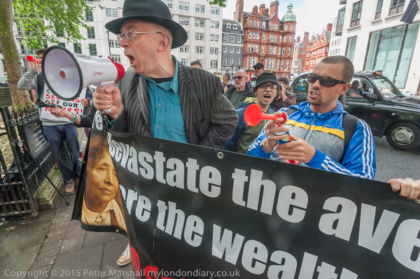
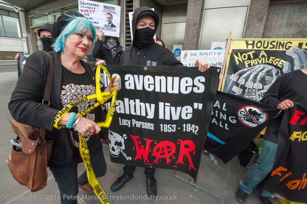
There are other crimes around housing in the UK, and in particular around social housing, and people were protesting about these before Grenfell. On Thursday 16th June 2016 I photographed one of these protests, and two days later a second also in Mayfair, an appropriate location as these are crimes of the rich against the poor, coming from the Thatcher crusade to enrich the rich at the expense of the poor, rewarding the wealthy and retreating from the welfare state which had supported the poor.

Housing Crimes Exposed

Housing was one of the main areas of policy, along with privatisation which sold off key services and industries to private investors – and for which we are now seeing the results in high energy prices, sewage in rivers, high cost transport and huge subsidies to shareholders, with much of the costs of our NHS now going to supporting healthcare companies and their owners.

In housing Thatcher decided we should be a nation of home owners. Until then many of the working class had either been council tenants or were aspiring to be so while living in often poor and cramped accommodation provided by private landlords. Thatcher changed that, partly be selling off council properties to tenants at knock-down prices, but also by making it difficult or impossible for local authorities to build new council properties or properly maintain existing ones. It was a very popular policy with those who got their properties on the cheap, though many found they couldn’t afford to keep them and before long they were bough up as ‘buy to let’ properties by those rich enough to get mortgages and bank loans.

Housing Crimes Exposed

Under New Labour, the Labour Party took up many of the worst of Thatcher’s policies, and the ‘regeneration’ schemes Labour councils came up increasingly amounted in a huge loss of social housing, replacing huge estates with largely homes for private sale with some as largely unaffordable “affordable housing” and shared ownership. More and more of the housing associations, many of which had taken over social housing estates from hard-pressed local councils began to look more and more like commercial property owners.

In 2021 government funding to housing associations to build affordable housing was reduced by 60% and funding for new social rented housing was stopped altogether. Since then they have built many houses for sale and rent at market levels, partly to provide cash for some social housing.

London’s councils, largely Labour run, have been among the worst offenders. As I wrote in 2016:

Under the guise of New Labour regeneration, Southwark spent large amounts of council money in demonising the Heygate Estate, employing PR consultants to invent surveys, deliberately moving in problem tenants, running the estate down both physically and through the media to justify its demolition. A highly awarded scheme with its trees coming to maturity, and popular with many residents despite the lack of necessary maintenance was emptied over a period of years and finally destroyed. It took years to get some residents to move, as few were offered suitable alternative accommodation and the compensation on offer to leaseholders was derisory.

But this scheme turned into “something of a financial disaster for Southwark council (though doubtless not for some councillors) and certainly for the people of Southwark, as the Heygate, built with around 1700 social housing units has been replaced by Elephant Park, with less than a hundred, along with a large number of high price apartments which very few locals can afford.”

Undeterred, Southwark proceeded to apply similar methods to other estates, notably the neighbouring Aylesbury Estate, “converting public assets into private profit, with yet more Southwark residents being forced to move out to cheaper areas on the outskirts of London or beyond, in what housing activists describe as social cleansing, driving ordinary Londoners out of the capital.

Similar polices were being applied under Mayor Robin Wales in Newham. They began emptying out the Carpenters Estate, a well-liked and successful estate close to the great transport links of Stratford station, in 2004. Many of the homes on the estate have been empty since then despite huge housing problems in the borough. A scheme to sell the estate for a new campus for UCL was defeated by protests both by local residents, led by Focus E15 and by students and staff at UCL.

Focus E15, a group of young mothers faced with eviction from their Stratford hostel when Newham announced they would no longer pay the housing association which ran it, engaged in a successful campaign against the council’s plans to relocate them separately to private rented accommodation in distant parts of the country, and brought housing problems in Newham and elsewhere onto the national agenda.

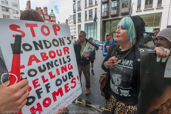
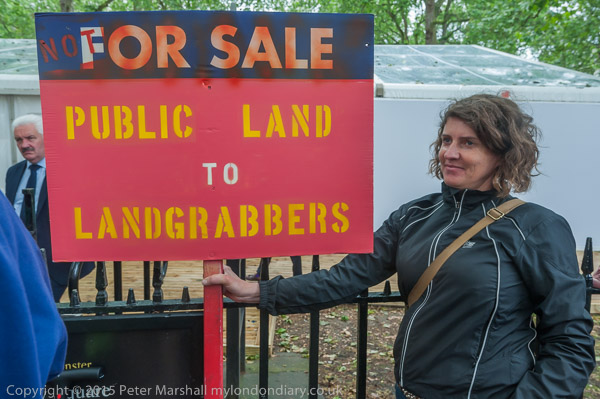
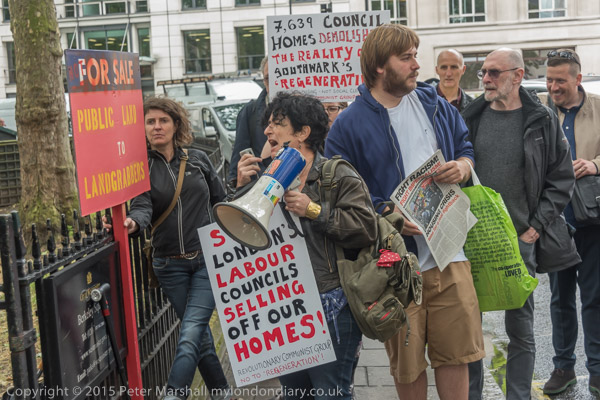
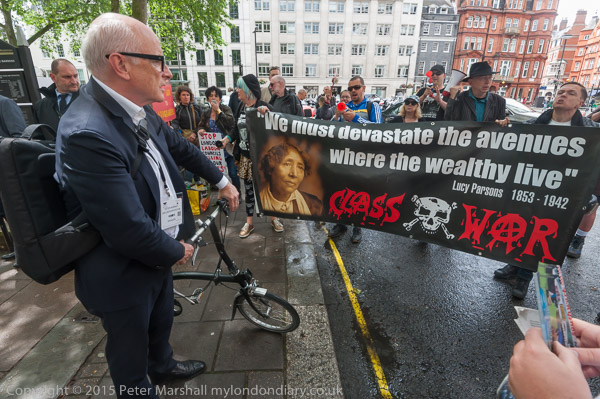
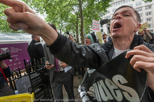
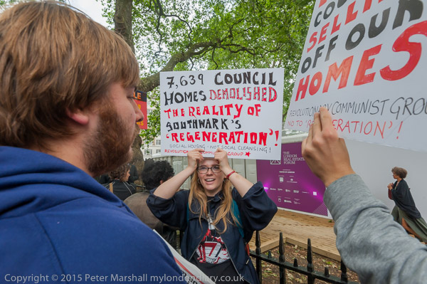
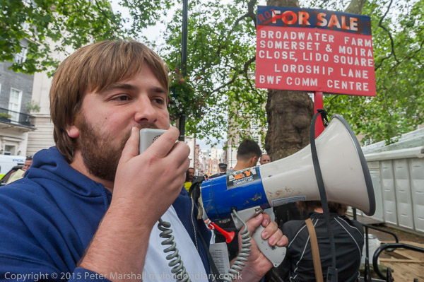
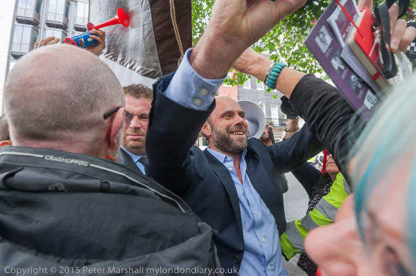
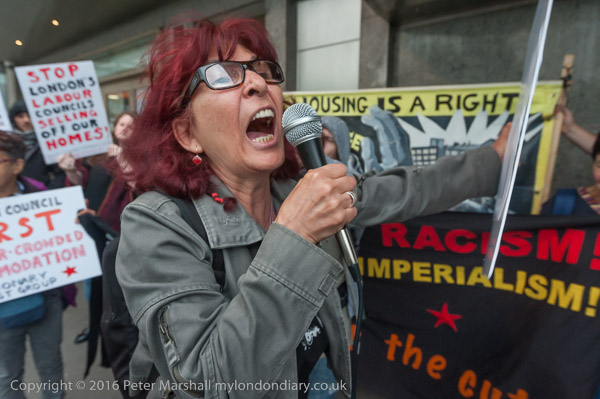
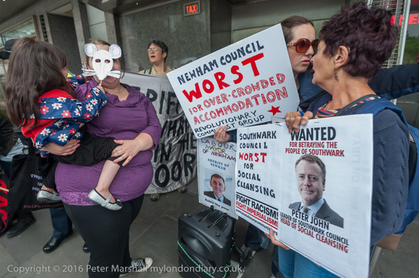
Focus E15 were among other groups, including Class War, the Revolutionary Communist Group and protesters from the Aylesbury Estate in Southwark who came to Berkeley Square to protest outside the London Real Estate Forum. Many Labour councils – including Southwark and Newham – were at the event, conspiring with estate agents and property developers to sell public land and transform estates which now house those on low incomes into homes for the wealthy. Councils now “appear to regard the estates they own as liabilities rather than seeing them as providing vital homes meeting the needs of the people who elect them. “

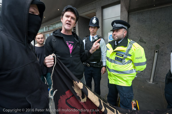
A few of those entering or leaving the event stopped to engage with the protesters, mostly trying to justify their activities. One man photographed the protest and engaged in homophobic abuse, but police who had been trying to move the protesters refused to take action.

You can read about the protest on My London Diary at Advance to Mayfair.


Municipal Journal Awards – Hilton Hotel, Mayfair

Two days later on Thursday 16th June 2016 I joined many of the same protesters and others outside the Hilton Hotel with Architects 4 Social Housing protesting noisily outside the Municipal Journal Local Authority Awards at the Hilton Hotel castigating the nomination of Southwark and Newham for awards.

They complained that Southwark was nominated for ‘Best London Council’ despite having demolished 7,639 units of social housing, sold off public land to developers, and evicted people unlawfully and accused Newham of social cleansing, rehousing people in distant parts of the country while council properties remain empty, and of causing mental health problems through evictions, homelessness and failure to maintain properties.

These were awards not for housing the workers in their areas, many of whom are on pay close or at the minimum legal levels. Not even for key workers such as teachers and nurses, few of whom can now afford properties in the areas close to where they work, but to attract high paid workers and provide profits for overseas investors, many of whom leave the properties empty all or most of the year, watching their profits grow as London’s high property prices increase.

They are awards too for contributing to the huge profits for the developers who are now building a new London, providing poorly built properties, often to lower standards of space than those they replace, and with design lives sometimes expiring much earlier. And because we have not seen the changes in building regulations and safety standards that Grenfell exposed as necessary, some at least may be the Grenfells of the future.

More about the protest and many more pictures at Municipal Journal Awards.


A Submarine, Flats, Pub, Dog, Ducks & Milkmaid

A Submarine, Flats, Pub, Dog, Ducks & Milkmaid is the final post on my walk on Friday afternoon, May 5th 1989. The previous post was Around Camberwell New Road – 1989

Camberwell Submarine, boiler room, Akerman Rd, Lambeth, 1989 89-5b-35

I crossed over Camberwell New Road to the southern side, turned own Vassall Road and then left into Langton Road. I’ve not digitised the one picture I took of a house here, nor the single image I made in Lothian Road, but I continued further south along here, lured by the sight of an unusual object in the centre of Akerman Road.

Two vertical concrete towers rose up from a more organic looking low concrete body. Later I was to learn that this was known as the Camberwell Submarine.

Camberwell Submarine, boiler room, Akerman Rd, Lambeth, 1989 89-5b-21

I had no idea what this structure was, though clearly it was providing ventilation for some below ground installation. Was it Lambeth’s nuclear bunker, perhaps an underground city? Was there some secret tunnel underneath – though the nearest Underground line was well over a mile away. Later I looked it up to find others had made similar speculations to mine, but of course the real purpose is rather more prosaic.

This is the visible structure of the below ground Myatt’s Fields North Boiler House designed by Michael Luffingham in the mid-seventies for Lambeth Council, and described at the time as Hollamby’s submarine after his boss, borough architect Ted Hollamby. An attempt was made to get it listed ten years ago but failed.

Camberwell Submarine, boiler room, Akerman Rd, Lambeth, 1989 89-5b-23

I could only walk around the outside of the submarine and although it had doors at each end, both were locked. In 2007, Mike Urban of Urban75 was photographing it and was invited inside by a maintenance worker and his post reveals some of the hidden secrets of the interior.

Flats, Akerman Rd, Lambeth, 1989 89-5b-26

These are some of the flats on the Myatt’s Fields North which were heated by the submarine. The estate later got a very poor reputation and much was demolished and replaced in controversial redevelopment in 2014, mentioned in a previous post.

Loughborough Hotel, Evandale Rd, Brixton, Lambeth, 1989 89-5b-14

I turned down Evandale Road and walked down to the Loughborough Hotel on the corner with Loughborough Road. The earliest record of a pub here – on the corner with what was then Cromwell Rd – was in 1864, and it was built on the site of Loughborough House which was demolished in 1854. This had been the Manor House of Lambeth Wick, home to the 1st Baron Loughborough, Henry Hastings. He had been given his title in 1643 for fighting for the Royalists in the English Civil War and returned to live here after a period of exile in 1661.

In 1900 the hotel was replaced by this splendid new building, designed as an entertainment palace with a large ballroom on the first floor. The name ‘Hotel’ simply meant it was a posher establishment than an inn, and it never had rooms where people could stay.

The nature of entertainment at the hotel changed from the late 1960s as did the local population. The Island Disco, a South Pacific Island themed disco opened in 1967 and various other night clubs followed including the legendary Latin and African music club, the Mambo Inn. There were drag nights too from !969.

All this finished in 2005, when the upstairs room s were turned into flats. The ground floor pub finally closed in 2007 and the former bar is now a café and possibly at times an art gallery.

Fiveways, Loughborough Rd, Akerman Rd, Brixton, Lambeth, 1989 89-5b-15

I turned east along Loughborough Road and made my way to Fiveways, the junction with Akerman Road, Lilford Road and Fiveways Road. This shows the house on the corner with Akerman Raod, which has since been considerably refurbished. This was once the end of a long terrace from the Loughborough Hotel with ground floor shops, but those at this end and some others have been converted to residential.

Dog, Ducks & Milkmaid, Lilford Rd, Camberwell, Lambeth, 1989 89-5c-62

I continued along Lilford Road, where at number 15 I photographed this small menagerie. I’m pleased to see that the ducks are still there on the short pillars at the front door, though now looking a little worn, but the milkmaid and dog have gone.

Auto Stores, Camberwell Rd, Camberwell, Southwark, 1989 89-5c-63
Auto Stores, Camberwell, Southwark, 1989 89-5c-63

By now it was getting a little late and I was getting hungry and I made my way quickly along Knatchbull Road towards Camberwell Green to catch a bus back to Waterloo for my train home. I only took this one last picture, though I’m not sure exactly where it was taken around Camberwell Green, though my contact sheet says Camberwell Road.

This is the third and final post on the walk which began with Naked Ladies, 3 Doors & A New Walk. But two days later I was back again on a new walk in South London which I’ll write about shortly


Flats, School, College, Houses, Temple, Shop

Flats, School, College, Houses, Temple, Shop: The final post on my walk on Sunday 9th April 1989. The previous post was Cold Harbour & Myatt’s Fields.

Houses, Cormont Rd, Myatts Fields, Camberwell, Lambeth, 1989 89-4j-44
Flats, Cormont Rd, Myatts Fields, Camberwell, Lambeth, 1989 89-4j-44

From Longfield Hall I wandered up Knatchbull Road to Cormont Road, which runs halfway around Myatt’s Fields Park on its southwest and northwest sides. I took half a dozen pictures which I haven’t digitised before coming to this on the corner of Brief Street which I think was built as flats. Almost all the buildings in the area are fine examples of late Victorian housing, largely in the Queen Anne style but there is perhaps a slightly overpowering amount of red brick directly onto the streets.

Houses, Brief St, Myatts Fields, Camberwell, Lambeth, 1989 89-4j-45
Flats, Brief St, Myatts Fields, Camberwell, Lambeth, 1989 89-4j-45

Another finely designed large block of flats a few yards down Brief Street, Burton House, its hedges a few years ago more tidily trimmed but now again reverting to wild. On the opposite side of the street is a short terrace of two storey houses with brief front gardens and Brief Street is appropriately short – a little under a hundred yards in length.

School, Cormont Rd, Myatts Fields, Camberwell, Lambeth, 1989 89-4j-34

According to Lambeth’s 2018 Character Appraisal for the Minet Conservation Area, “Kennington Boys’ High School (latterly known as Charles Edward Brooke School), Cormont Road opened in 1897.” This was a LCC board school and the Grade II listing states that this building dates from 1912, architect T J Bailey. It is listed on Historic England’s Heritage At Risk Register.

Confusingly – and I hope I have got this right – the school renamed itself Saint Gabriel’s College when it became co-educational as a Specialist Arts and Music College in 2012, and then moved out to Langton Road a few years later.

Myatts House, Cormont Rd, Myatts Fields, Camberwell, Lambeth, 1989 89-4j-35

Again from the Lambeth appraisal, “The former St. Gabriel’s College on Cormont Road opened in 1899 as a training college for Anglican schoolmistresses, the vision of Charles Edward Brooke, a senior curate of nearby St. John the Divine church; the attached chapel was added in 1903.” The style is described as “vaguely Art Nouveau“. In 1989 it was Myatts House, run by the ATC Group of Training Companies and offering courses in Accountancy, Finance, Management and I think Computers, though the final word on the sign is hard to read. Grade II listed.

The building was requisitioned in the First World War, becoming part of the 1st London General Hospital, and was where Vera Brittain was first stationed. Later it became a LCC rest Home. It is now residential, converted to expensive flats as St Gabriel’s Manor.

Calais Gate, Mansions, Cormont Rd, Myatts Fields, Camberwell, Lambeth, 1989 89-4j-36
Flats, Cormont Rd, Myatts Fields, Camberwell, Lambeth, 1989 89-4j-36

This is Calais Gate, also Grade II listed and said in the listing to date from the early 20th Century, though the Myatt’s Park history site dates that these large mansion blocks as c. 1895.

Perched on top of the fine stepped gable is a terracotta cat, one of a number of cats on buildings on the Minet estate, though most are rather less prominent. The whole estate was developed by the Minet family who were of French Huguenot origin, and their name is an affectionate or childish French term for a cat, (minette if the cat happens to be female.)

Houses, Calais St, Myatts Fields, Camberwell, Lambeth, 1989 89-4j-22

Substantial houses in Calais St facing the park on the north-east side. I wondered when I took this on the significance of the gateway at left with the cross above, but am no wiser now. Hard to make out from this picture but those are cats heads above the doorway.

Houses, Flodden Rd, Myatts Fields, Camberwell, Lambeth, 1989 89-4j-24

Fine railings and decorative elements on these houses at 22 and 24 Flodden Road make them stand out and the absence of cats perhaps suggests these large semidetached Queen Anne style houses were not a part of the Minet development. Instead there are leaves and floral motifs and human heads.

Flodden was the site of a battle in 1513 in Northumberland, close to the border with Scotland when the English Army soundly defeated the army of King James IV of Scotland. England were engaged in a war with France and the Scottish invasion was in support of the ‘Auld Alliance’ they had made with France in 1295.

Calvary Temple, Councillor St, Camberwell, Lambeth, 1989 89-4j-11

It was time for me to leave the area, and I walked up Flodden Road to Camberwell New Road to get a bus, coming out almost immediately opposite Calvary Temple of the United Pentecostal Church a few yards to the north of the road in Councillor St.

The church incorporates a memorial stone “laid by William Appleton Esq (Sutton), June 2nd !890″ with the text “Hitherto Hath the Lord Helped Us” (1 Samuel 7:12), naming George Baines Architect and H L Holloway Builder. The church, then Clarendon Chapel, opened as a Baptist church in March 1891, replacing an earlier ‘tin tabernacle’ which had burnt down in 1889. Clarendon Street became Councillor Street some time before 1912 and the church was renamed Camberwell New Road Church, continuing in use for Baptist worship until the 1950s.

It narrowly escaped demolition in 1959 when it was saved by Caribbean immigrants who were looking for a building for their Pentecostal worship and they held their first service there in March 1959. They kept and restored the churches original late Victorian fittings and it remains in use.

Then and now it makes a dramatic composition with the tower block behind, Laird House on Redcar St, one of five 22-storey 210ft blocks on the 1966 LCC Wyndham & Comber Estates.

New Road Bargains, Camberwell New Road, Lambeth, 1989 89-4j-12

There are few if any shops in Myatt’s Fields but several parades within walking distance including on Camberwell New Road where at 243 was New Road Bargains with a small chair fixed above its door and a wonderfully packed window of assorted items. For some years this has been Camberwell Daily, now with a shop front that offers GROCERIES | FRUIT & VEG | OFF LICENCE | NEWS & MAGS.

I might have photographed other shops in the row, but my bus came and I got on it to begin my journey home.

This was the end of my walk on on Sunday 9th April 1989. The posts on it begin at Peckham and East Dulwich 1989.


Cold Harbour & Myatt’s Fields

My walk on Sunday 9th April 1989 continues in this post, Cold Harbour & Myatt’s Fields. The previous post was Camberwell & Myatt’s Fields.

Church, Shop, Coldharbour Lane, Camberwell, Lambeth, 1989 89-4j-61

Back in 1989 I was still pretty pressed for cash, still buying film in bulk 100 ft lengths and loading it into cassettes myself in total darkness.

Over the years I’d perfected my method. Two nails on the back of my darkroom door, hang one of the sprocket holes at the end of the roll of film on the top one, unroll it down to the second, cut across, replace film in can. Pick up first spool from a waiting row on the bench, already with a short length of masking tape on it, attach to the bottom end of the hanging length of film, carefully roll it up to the top, remove from nail, pick up cassette body, insert spool with film end though velvet light trap, pick up end cap and pinch cassette to push it into place. Repeat another 18 times until the film roll is finished. Turn on light, trim film ends to fit cameras and put into plastic pots to go into camera bag.

Slow, tedious but then less than half the cost of buying film in 26 exposure cassettes, though I did ocasoinally treat myself – and if I bought Ilford film rather than Kodak I could reuse the cassettes with bulk film. Kodak had crimped on ends which had to be removed with a bottle cap remover destroying them.

I had learnt to be very careful with film in this project to photograph London, working with 35mm cameras much as I would have done with large format camera, carefully considering various viewpoints before deciding on an exposure. But when working with people I had to respond rather more quickly, and seeing these two men in front of the white church door my response was immediate.

Shops, Coldharbour Lane, Camberwell, Lambeth, 1989 89-4j-62

After that rather snatched image I continued with photographing the two shops which had attracted my interest here, making first a vertical image and then moving back across the road for a wider view. In this (below) you can see the notice for the Celestial Church of Christ and the alley leading to this.

Shops, Coldharbour Lane, Camberwell, Lambeth, 1989 89-4j-63

As well as these black and white images I also took a couple in colour which you can see in another album. I had two Olympus OM bodies with me and only brought the one with colour negative film out of my bag occasionally, while the black and white camera was usually on a strap around my neck. When I was intending to photograph people rather than buildings I usually went out with a Leica M2 instead.

Coldharbour Lane leads from Camberwell to Brixton and got a very bad reputation after the 1981 clashes between police and locals in Brixton. In 2003 it was called in an article in the London Evening Standard the most dangerous street in the most dangerous borough in London, but that was lagely rabid tabloid journalism. Wikipedia gives several theories about its name none of which seem entirely convincing, but the name seems often to have been associated with the ruins of Roman or Romano-British settlements, The area we know usually call Loughborough Junction around the station on early maps was called Cold Harbour. Coldharbour Lane was then known as Camberwell Lane.

Cafe,  Hinton Rd, Camberwell, Lambeth, 1989 89-4j-65
Café, Hinton Rd, Camberwell, Lambeth, 1989 89-4j-65

The S&J Corner Café was on the corner with Wellfit Street, close to Loughborough Junction station. The railway line here is just south of the station. A second bridge can be seen going above this and the cafe which is the line from Brixton to Denmark Hill, now used by London Overground services.

Cyclist, HInton Rd, Camberwell, Lambeth, 1989 89-4j-51
Cyclist, Hinton Rd, Camberwell, Lambeth, 1989 89-4j-51

Another picture I took on the spur of the moment as I saw a cyclist coming towards me under the bridges on Hinton Road. I was standing on the pavement beside the cafe in the previous image, and the cyclist is on the pavement, rather safer than roads like this in London. At the end of the row of shops on the left are the traffic lights and Coldharbour Lane whch I had just begun to walk towards.

Hinton Rd, Camberwell, Lambeth, 1989 89-4j-52

The pub at right of this picture is The Green Man on the corner with Coldharbour Lane. According to a post on the Brixton Buzz, this had been on the site since 1881, but that is the date of the current building which replaced an earlier pub on the site important enough to be marked on Stanford’s 1862 map. The Buzz says it was closed in 2003 because of drug dealing and crime, and it quotes from the Urban75 blog that it was “was frequented by dealers (crack, heroin you name it), prosi’s and general madhatters.

The buildings at the left date from around the same time as the area was developed around the railways, and number 6 at left has a barely legible road name ‘Hinton Terrace‘ and I think at the top the illegible name of a builder and decorator whose sign presumably once hung on the bracket beside the street name.

House, Lilford Rd, Camberwell, Lambeth, 1989 89-4j-53
Houses, Lilford Rd, Camberwell, Lambeth, 1989 89-4j-53

I walked up past Loughborough Junction and made my next picture on Lilford Road at the corner of Minet Road, returning to the area I had been earlier on this walk, the Minet Estate around Myatt’s Fields. This is on the corner of a terrace with basement flats with an entrance here under the steps which extends along both streets and this grand entrance is actually for two adjoining houses above the flats, one on each street. The Grade II listing calls these “Early-mid C19″ and describes this a “double prostyle composite porch with fluted composite columns.”

Longfield Hall, Knatchbull Rd, Myatts Fields, Camberwell, Lambeth, 1989 89-4j-54
Longfield Hall, Knatchbull Rd, Camberwell, Lambeth, 1989

William Minet founded this Grade II listed community hall, architect George Hubbard, which opened in 1889, as well as the Minet library opposite which was destroyed by bombing and rebuilt in 1956 in what Pevsner described as ‘a meek replacement’. The Library was a memorial for his late wife. The Hall is still in use for various community activities including three church congregations and from 1969 -1975 was the base of Britain’s first Black Theatre Company, ‘Dark And Light’, recently marked by a Blue Plaque. It was Grade II listed in 1979 and is now run by a charity, The Longfield Hall Trust.

My walk made on on Sunday 9th April 1989 will finish in a later post. The first part from it is at Peckham and East Dulwich 1989.


Camberwell & Myatt’s Fields

My walk on Sunday 9th April 1989 continued. The previous post was Hairdressers, Mansions, Baptists, Tiles and Greeks.

Escort Parts Centre, Camberwell Station Rd, Camberwell, Southwark, 1989 89-4i-43

Camberwell Station Road runs south from Camberwell New Road alongside the railway line, and along its west side are a number of small businesses in the railway arches, almost all garages of some kind.

The Escort Parts Centre was on the corner with Camberwell New Road and remained in business here until around 2010. The premises are now covered with graffiti and look derelict. The number 344 does not appear to be for either street and I think is some numbering for the arches in the viaduct.

Sacred Heart of Jesus, RC Church, Camberwell, Southwark, 1989 89-4i-32

The Roman Catholic Church of the Sacred Heart is in Knatchbull Road, just past the railway bridge and is on a dramatic scale, towering above the railway viaduct.

The Grade II listing text states it was built in 1952-8 from designs by D Plaskett Marshall in a moderne style, reminiscent of the inter-war churches of Cachemaille-Day. According to Wikipedia, “Nugent Francis Cachemaille-Day (1896–1976), often referred to as NF Cachemaille-Day, was an English architect who designed some of the most “revolutionary” 20th-century churches in the country.

Again according to Wikipedia he designed his first church in Northenden in 1936-7 and by 1963 had been responsible for at least 61, many Grade II listed. Because of its location it is difficult to get a picture of this one which provides a good overall impression.

Tyre Fitting Bay, Camberwell Station Rd, Camberwell, Lambeth, 1989 89-4i-36

This was little further down Camberwell Station Rd which hasn’t had a passenger station since 1916 , though if you go down far enough you can still see the former station building, now occupied by a motorbike repair shop.

Camberwell station opened in 1862 on the London, Chatham and Dover Railway’s line into Blackfriars from Herne Hill. After the closure for passengers it remained in use for goods until 1964. The goods yard is now a housing estate.

Various schemes this century have looked at the reopening of the station but all so far have been abandoned.

Houses, Myatts Fields area, Camberwell, Lambeth, 1989 89-4i-25
Houses, 22-24, Flodden Rd, Myatts Fields, Camberwell, Lambeth, 1989 89-4i-25

I walked back up to Camberwell New Road and took three pictures of terraces there ( not on-line) before going down County Grove. These houses are 22 and 24 Flodden Road. On my map the Southwark-Lambeth boundary runs down the middle of the road, making these in Lambeth.

The Survey of London states that this area was bought from Sir Edward Knatchbull in 1770 by Hughes Minet, the grandson of a French Hugenot refugee, but it was only after the railway was opened in 1863 that it was developed to meet the demand this generated for small suburban houses. Builders obtained leases from the Minet family who were public-spririted landlords and provided a church and the Minet library and also closely controlled the building ensuring a mix of house sizes. In 1889 William Minet gave the 14.5 acres to the London County Council for a permanent open space, Myatt’s fields.

Houses, Myatts Fields area, Camberwell, Lambeth, 1989 89-4i-11
Upstall St, Myatts Fields, Camberwell, Lambeth, 1989 89-4i-11

The Metropolitan Public Gardens Association spent around £10,000 to lay it out as a park to the designs of Fanny Wilkinson, a suffragette and one of the first women to be a professional landscape designer. The new park was named for Joseph Myatt, a well-known market gardener who produced a number of then famous strawberry varieties including Eliza, British Queen and Deptford Vine at his nursery in Deptford. His son James Myatt brought the business to the fields here.

Joseph also experimented with various varieties of rhubarb, hoping that he could get people to eat this together with strawberries, but this proved rather less successful, though rhubarb did become popular later.

Lambeth Council became the freeholder of the Minet estate in 1968.

Paulet Rd, Camberwell, Lambeth, 1989 89-4i-12

Lambeth Council redeveloped a large stretch along the west side of Paulet Road in the early 1970s. Although the long terrace blocks of the Paulet Road Estate are in a modern style they have a similar scale to the Victorian terraces opposite and were built using yellow stock bricks and slates like them. But they still look like monolithic slabs rather than the repeating units of the earlier houses.

Paulet Rd, Camberwell, Lambeth, 1989 89-4i-13

The side and rear of one of the blocks on the Paulet Road Estate. I think that these stairs lead up to the front doors of the upper level flats. These buildings are some of relatively few modern buildings in the Minet Conservation Area designated in 1980.

Provision Shop, Lilford Rd, Camberwell, Lambeth, 1989 89-4i-15

The south end of Paulet Road ends at Lilford Road and I turned east along it, going under the railway again. I think this shop just a little to the east of the railway bridge was at No 106 and has been converted into a private residence and is no longer recognisable. There are many fewer small corner shops now.

My walk will continue in a later post. The first part my walk on Sunday 9th April 1989 is at Peckham and East Dulwich 1989.


Hairdressers, Mansions, Baptists, Tiles & Greeks

The first part of this walk I made on Sunday 9th April 1989 is at Peckham and East Dulwich 1989.

Hairdresser, North Cross Rd, East Dulwich, Southwark, 1989 89-4i-61

I’d taken a picture of this poster in a hairdresser’s window when I’d walked along North Cross Road a couple of months earlier but hadn’t been entirely satisfied with it. In winter I had been working with Kodak’s TMAX400 and I think I felt that the fine graphic detail on the poster would be better on the more fine-grained TMAX100 I had switched to for the summer. The difference isn’t huge but it does show. The framing is also a little different, though in making this digital image I have made this version just a little more skewed than my usual slight lean. I blame it on living in a house where nothing is quite a right angle.

North Cross Rd, East Dulwich, Southwark, 1989 89-4i-62

I’m not sure what the shop at 65 North Cross Road was then selling but I rather liked the graphic on the window. It could have been, as it now is, another hairdresser. The doorway was for the flat above.

Fruit & Veg, Coldharbour Place, Camberwell, Lambeth, 1989 89-4i-63
Coldharbour Place, Camberwell, Lambeth, 1989 89-4i-63

I think I may have jumped on a bus on Lordship Lane to take me to Camberwell Green. Coming up to London for many of these walks I used a Travelcard which had first been introduced by the Greater Londo Council in 1981 and had greatly simplified travel around London. At the beginning of 1989 it had been extended to cover British Rail services, replacing an earlier One Day Capitalcard. The GLC had lost a legal battle to cut London fares in 1982, and was abolished by Thatcher in 1986, with fairly disastrous consequences, but their rationalisation of travel continued. Without it I don’t think I would have been able to do much of my extensive work across London. Now it seems that Tory cuts are going to force TfL to get rid of it for those of us travelling into London.

This is the next frame on my film, and was made around a mile and a half away, probably around a 15 minute bus ride from the previous image. The picture was made from Coldharbour Lane looking down Coldharbour Place, which continues with a narrow alley to Denmark Hill. The large building at left was a garage and has now been replaced by a larger block of flats, but the buildings at the right which front onto Denmark Hill remain and the wall at right is now covered by the ‘Great Wave’ mural based on Hokusai’s iconic image.

Denmark Place, Baptist Church, Coldharbour Lane, Camberwell, Lambeth, 1989 89-4i-64

This Grade II listed church was built in 1823 and though some alterations were made in 1869 still looks remarkably like it did in Victorian times. I wounder why it has four doors along its frontage, and is without a central door. Possibly the doors at the left and right of the set may lead to galleries around the main hall, and some more strict churches had separate doors for men and women, but although the listed text has a fairly full description of the exterior it gives no clues for the reasons behind the design.

Shops, Coldharbour Lane, Camberwell, Lambeth, 1989 89-4i-65

A rather fine row of shops with flats above, Denmark Mansions at 78-96 Coldharbour Lane. These mansions replaced earlier semi-detached villas with front gardens on the street at some time around 1900 though I can find no exact date.

Kenbury St, Camberwell, Lambeth, 1989 89-4i-51

A derelict frontage in Kenbury St, just off Coldharbour Lane. This is part of Kenbury Mansions and has long been restored. These buildings are rather decorative fronts on a rather large solid block behind, each front door leading to half a dozen flats.

Arcanum Works, Warner Rd, Camberwell, Lambeth, 1989 89-4i-54

Arcanum means the mysteries or secrets of a subject but other than the name I’m unsure what was mysterious about the Arcanum Terrazzo & Stone Company Limited who shared this works with the Decorative Tile Company Limited and the yard at rear with Wandle Paving Ltd.

This building is still there, but is now the Glory Divine Christian Centre & Community Hall. The factory behind is labelled as a Brewery on the 1877 OS large-scale map, but by the time of the 1916 OS map had turned sour as a Vinegar Works.

St Marys Greek Orthodox Cathedral, Camberwell New Rd, Camberwell, Lambeth, 1989 89-4i-55

The Greek Orthodox Cathedral of the Nativity of the Mother of God, Camberwell is a church in the Archdiocese of Thyateira & Great Britain. Greek Orthodox Christians had begun to celebrate in nearby St Giles in 1962.

In 1963 they moved into and later bought the former Catholic Apostolic Church, Camberwell New Road built for this splinter group of Anglo-Catholics in 1877, architect J & J Belcher. They had worshipped there until 1961. The church was damaged by bombing in 1941 and lost the impressive frontage rising behind the cloisters which can be seen in an illustration on Archiseek.com – with almost half the former nave now being a courtyard.

St Marys Greek Orthodox Cathedral, Camberwell New Rd, Camberwell, Lambeth, 1989 89-4i-42

I peered into the rather strange buildings to take this picture of the cloisters which the Anglo-Catholics had required of the architect. The more recent addition at left is probably very practical but rather spoils the impression.

My walk will continue in a later post. The previous post was the first on this walk, Peckham and East Dulwich 1989.