Hackney Wick Allotments

Allotments, Waterden Rd, Hackney Wick, Hackney, 1983 36o-15_2400

One story is that some time in the late 1870s boys in the King’s College of Our Lady of Eton beside Windsor, the chapel of Eton School were visited by an apparition of the Blessed Virgin Mary which led them to set up a charitable settlement in Hackney Wick, then one of the most deprived areas of London. It was a time when other similar settlements were being set up elsewhere in the capital and the history of St Mary of Eton states that “In 1880, William How, Bishop of Bedford, persuaded the masters and boys of Eton College to establish a mission and support a priest in … Hackney Wick.”

The Grade II* listed church of St Mary of Eton with St Augustine, according to the listing text “was built 1890-2 to the designs of George Frederick Bodley, under the title Bodley and Garner. Enlarged 1910-12 at the west end, with vestries and tower added by Cecil Hare, Bodley’s successor.” This also calls William How “first Bishop of Wakefield”. The St Augustine was added to its title when parishes were combined in 1953.

Allotments, Waterden Rd, Hackney Wick, Hackney, 1982 32z-53_2400

As well as providing a church there were other buildings used for various clubs and actitivites, including a Boys Club was established by the mission in 1880 and various sporting activities including the Eton Mission Rowing Club founded in 1885. Many Old Etonians came to support the mission, including Gerald Wellesley, a grandson of the Duke of Wellington, who together with Alfred Ralph Wagg, Sir Edward Cadogan and Arthur George Child-Villiers, in 1909 set up an Old Boys’ Club independent of the Mission. Various other clubs were formed as subsidiaries to this, including a short-lived ‘Junior Bachelors’ Club’ which rewarded members with four trips a year for promising they would not ‘walk out with young ladies’. As most who joined failed to keep their promise the club was soon abandoned.

The Bridge over the River Lea to Manor Gardens allotments. 2007

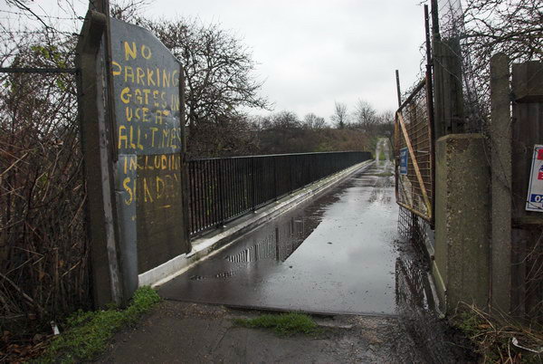
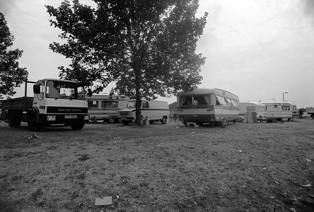
During the First World War there were shortages of food due to the torpedoing of British merchant ships bringing provisions from the colonies, and the club made parts of 30 acres of land across the River Lea from Hackney Wick, in Leyton available to club members as allotments. By the 1920s the main figure in the Eton Manor clubs was Major Villiers, a director of Barings bank, and one of the allotment gates I photographed in 1982 has the notice ‘Major A Villiers Gardening Club Private’ on it. The second pleads ‘Please Leave The Old Age Pension Plots Along You May Get Old One Of Thes Days’ – the Old Boys had grown very old over the years. Major Villiers lived in a house on the Eton Manor Boys Club sports grounds, known as the Wilderness on Ruckholt Rd and Temple Mill Lane from 1913 until his death in 1969 but decided in 1967 to close the club.

One of the 80 plots at Manor Gaardens. 2007

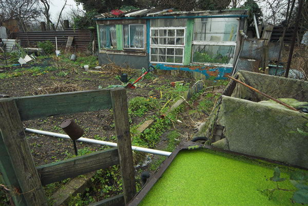
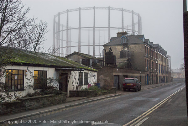
One of these allotment areas, reached by a bridge on a road leading over the River Lea was the Manor Gardens Allotments, and this continued to be a thriving community there until it was evicted in 2008 when its land was taken for a path in the London 2012 Olympic site. The allotment holders put up a strong fight to be allowed to remain in situ, but although the land they were on was not a vital part of the site, they very much represented an activity which the promoters of elite sports felt was undesirable. They had to go, along with the pylons and Hackney Wicks vibrant graffiti in a tidying up of the area which left it sterile – and from which it is only now beginning to recover some atmosphere.

2007

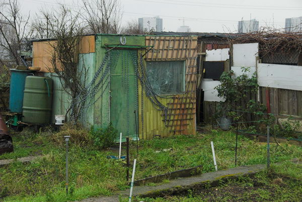
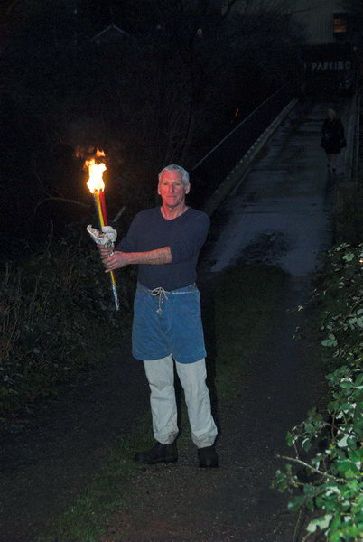
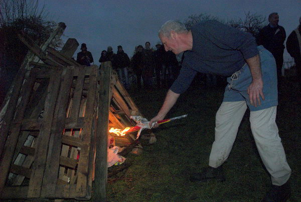
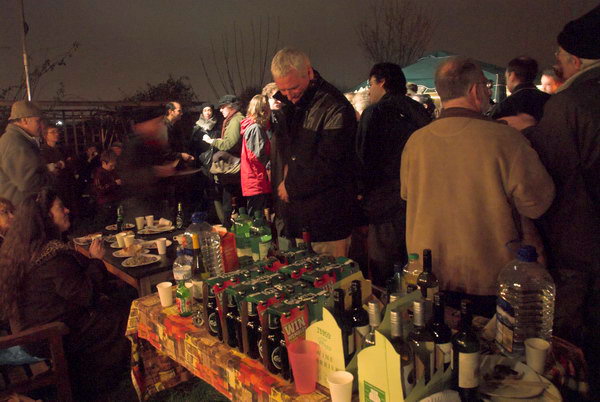
Manor Gardens put up a strong fight to remain, enlisting the support of many celebrities (though unfortunately the links with Eton had long disappeared or they might have been more successful.) I paid a number of visits to the allotments and various events they organised. The colour pictures heres are from their New Year Feast in January 2007, which included a runner with a mock Olympic flame who lit the bonfire, several celebrity speeches, an exhibition and a party.

A runner stands ready with the ‘Olympic Flame’. 2007
and uses it to light the bonfire. 2007
And the party continues. 2007

For those of us concerned about the environment (and there are now rather more than when the 2012 Olympics were being planned) the failure to preserve the Manor Gardens allotments was a real missed opportunity. It could have been seen as a golden opportunity to give the games some green credibility behind the lip-service the bid gave to biodiversity and sustainability, and certainly as a commitment to the post-2012 legacy of the games – to leave sites such as Manor Gardens and the adjoining nature reserve as a green centrepiece to the site. Unfortunately the architects and developers seem hell-bent to create a brown Olympics, creating an irredeemably distressed site that will only be economically recoverable when all the concrete has crumbled.

It would be a great shame to lose this splendid facility for four weeks of use in 2012, when it could easily be built around. It isn’t in a critical area but will simply be under concrete as a footpath, and probably also the site of a huge advertising ‘scoreboard’ for the games sponsor.

What will it say about the 2012 Olympics for a site that is currently a beacon for healthy green eating to be used for selling big macs?

New Year Feast – Manor Garden Allotments

All photographs on this and my other sites, unless otherwise stated, are taken by and copyright of Peter Marshall, and are available for reproduction or can be bought as prints.


Hackney Wick (1)

Waterden Rd, Hackney Wick, Hackney, 1982 32z-65_2400

Thinking about the New Year – or about the past one – simply makes me feel angry and depressed, and though I started to write something I couldn’t finish it. There is plenty of stuff already on the web and in print about it. So I decided to continue writing and posting pictures about my project from the 1980s on the Lea Valley. And so to Hackney Wick.

Eastway/Waterden Rd, Hackney Wick, Hackney, 1982 32z-66_2400

Not that Hackney Wick presented an encouraging face back in 1982. It had been an important industrial area in previous years, but now industry was in terminal decline, with Thatcher abandoning the idea of manufacturing in favour of services, accelerating its decay, driving to a post-industrial future.

Hackney Wick, Hackney, 1982 32k-31_2400

There was a bleakness too in the Greater London Council’s Trowbridge Estate, with its seven 21 storey blocks completed between 1965 and 1969. It provided much-needed housing but by the 1980s was showing evidence of neglect, but there was still considerable local opposition to the series of demolitions which began in 1985 three years after I took this picture in 1982. By 1987 three blocks had been demolished, and they were all gone by 1996, with some spectacular pictures and video being taken of some of them being blown up – not always very effectively.

Hackney Stadium, Waterden Rd, Hackney Wick, Hackney, 1982 32z-52_2400

Hackney Greyhound Stadium only finally closed in 1997, but was struggling for some years. Going to the dogs had gone out of fashion. It had begun in the UK in the late 1920s, an import from the USA where it had started in California in 1919, and its heyday was in the 1930s, with the Hackney Wick Stadium having its first race meeting on April 8th 1932. Later the stadium was also used for Speedway and Midget Car racing. I never went to Hackney Stadium and my only visit to dog racing was by mistake at Wimbledon Stadium around 1960 where I went on several occasions with a friend who was a speedway fan, and one week he got the dates mixed. I didn’t enjoy it.

BRONCO, British Patent Perforated Paper Co, Atlas Works, Berkshire Road, Hackney Wick, Hackney, 1982 32k-46_2400

Among the many products which previous generations relied on Hackney Wick for was toilet paper, which for many years was made at the Atlas Works by the British Patent Perforated Company, better known as Bronco. We now live in softer times and their less porous and more hygenic product went out of favour. This was first patented in the USA in 1870, but Hackney Wick can claim to be the source of many inventions.

Wallis Rd, Hackney Wick, Hackney, 1983 36n-44_2400

Before Bronco, the Atlas Works were home to dyestuffs company Brooke Simpson Spiller who had taken over the company set up by the founder of the synthetic dyestuff industry William Henry Perkin. There they employed several of the leading organic chemists of the late 19th century who developed a number of new dyes. My own very brief and much less illustrious career as an industrial chemist also began (and very soon ended) in dyestuffs, but at a west London company – and the lab there was still using some samples signed on the bottle by Perkin himself.

Queens Yard, Whitepost Lane, Hackney Wick, Tower Hamlets, 1992 92-8d26_2400

It was in Hackney Wick that the first synthetic plastic, Parkesine was manufactured, and where oil distillers Carless, Capel & Leonard marketed the first product to be given the name Petrol, and also where dry-cleaning came to the UK thanks to Achille Serre. But the largest and best-known of the Wick’s industries was Clarnico (until 1946 Clarke, Nickolls,Coombs until 1946) who opened a jam factory here in 1879 and went on to produce many well-known sweets – a total of over 700 varieties – in what became the largest sugar confectionary factory in Britain, but closed in 1973. You can read about it at the Wick Curiousity Shop site, which also has a photograph of me and a few from my web site.

Kings Yard, Carpenters Road, Hackney Wick, Hackney, 1992 92-8d15_2400

Other products from the Wick you may have eaten include Fray Bentos pies, produced here by a part of the huge Vestey meat company from 1958. The pie business was sold on to Brooke Bond, acquired by Unilever and finally sold to Campbell’s Soup in 1993, when they promptly moved production away from Hackney.

More from Hackney Wick in another post.


All photographs on this and my other sites, unless otherwise stated, are taken by and copyright of Peter Marshall, and are available for reproduction or can be bought as prints.


Clapton – Lea Valley 1982

2020 is a year I don’t think I want to look back on, so I’ll eschew that traditional filler and instead look back rather further to continue my series on walks in the Lea valley in the 1980s.

Works, Upper Clapton or South Tottenham, Hackney or Haringey,1982 32c-42_2400

This time of year it has been a tradition for at least some of my family to get together to go on sometimes fairly lengthy walks, usually somewhere in the country. It’s something that has rather tailed off over the years, with both my sons now having young children, and also as my own legs getting old and tired, making anything over six or seven miles something of an ordeal.

Flats, Anchor & Hope, High Hill Ferry, Clapton, Hackney, 1982 32c-41_2400

This year things have become even more difficult, with us all under Tier 4 restrictions on travel etc and in different parts of the country, so our meetings have only been virtual. And although Linda and I have managed some short walks – around 5 miles on Boxing Day – these have all started and finished at our home. But at least I can take a digital walk in the Lea Valley.

Playing Field, Leyton, Waltham Forest, 1982 32c-44_2400

These pictures were not all taken on the same walk, which is one I did several times when working on my Lea Valley project and have repeated parts of rather more times since, sometimes riding on my Brompton folder. Parts of it have changed dramatically over the years, and wherever in these pictures you see a timber yard, factory or power station there is probably now several blocks of flats.

Clapton, Hackney, 1982 32u-64_2400

So many changes make it difficult for me to pinpoint the exact locations of some of these pictures, though others have very recognisable landmarks – such as the railway viaduct in the background above, now with a blue plaque celebrating the work of Alliott Verdon Roe, the first man to build and fly an entirely British aeroplane, built here in one of its arches, back in 1909.

Latham TImber, Clapton, Hackney, 1982 32c-31p (2)_2400

But Latham Timber is long gone, along with its neighbouring yard and the fences on which ‘The Gruesome’ staked their territorial claim and on which P & R pledged their ‘Forever True’ love in white paint on 16-8-82. Where are they now I wonder as I look at these pictures? Though so far as I’m aware I never saw any of them back in 1982 either.

33a-54_2400

The Gruesome Clapton, Hackney, 1982 33a-65_2400

The Gruesome Clapton, Hackney, 1982 33a-63_2400

Latham TImber, Clapton, Hackney, 1982 32c-56_2400

Middlesex Wharf, Clapton, Hackney, 1982 33a-52_2400

More pictures at River Lea – Lea Navigation 1981-1992. My next post in this series will look a little downstream.


All photographs on this and my other sites, unless otherwise stated, are taken by and copyright of Peter Marshall, and are available for reproduction or can be bought as prints.


Towards Hackney Wick 1982

I continue my virtual walk downriver towards Hackney Wick.

Clapton Park Estate, Clapton Park,  Hackney, 1982 32k-64_2400

Past the Clapton Park Estate: Norbury Court, Bakewell Court, Ambergate Court and Sudbury Court at 172 Daubeney Road, each 20 stories with 114 flats, approved by Hackney Council in 1968. Three were demolished by explosions in 1993-5 but Sudbury Court was sold to a private developer who gave it a relatively minor make-over and renamed it Landmark Heights.

Clapton Park Estate, Clapton Park, Hackney, 1982 32k-53p_2400

Somewhere I passed a canal-side factory –

Hackney Wick, Tower Hamlets, 1983 36n-46_2400

as well as the wide expanse of Hackney Marshes, with what must surely be more football pitches and anyone needs

Hackney Marsh, Hackney Wick, Hackney, 1982 32z-62_2400

as well as some wilder areas where the hogweed grows

Hackney Marsh, Hackney Wick, Hackney, 1982 32u-13_2400

and was ambushed by a group of children

Hackney Wick, Hackney, 1982 32k-51_2400

who demanded I take their pictures.

Hackney Wick, Hackney, 1982 32k-42_2400

Clost to Eastway I came across a travellers site

Travellers site,  Eastway, Stratford, Newham, 1983  36o-12_2400

close to the River Lea, here looking a very serious river away from the navigation.

River Lea, Eastway, Stratford, Newham, 1983  36o-13 (2)_2400

My walk continued but in a less linear fashion wandering around Hackney Wick – in the next episode. You can see all the pictures and more in my album River Lea – Lea Navigation 1981-1992.


All photographs on this and my other sites, unless otherwise stated, are taken by and copyright of Peter Marshall, and are available for reproduction or can be bought as prints.


Lea Valley 1993 – Around Tottenham Hale

Stonebridge Lock, Northumberland Park, 1983 37c-22_2400

Continuing my pictures from walks along the River Lea and Lea Navigation in 1983 which are in my Flickr album River Lea – Lea Navigation 1981-1992.

Tottenham Hale station on the Victoria Line was a convenient starting point for walks both north and south along the Lea navigatiion, which is crossed by Ferry Lane around 200 metres from the station.

Stonebridge Lock is around 3/4 miles north up the path from Ferry Lane, where steps lead down to the towpath immediately after you cross Pymmes Brook. The view above is looking south back towards Tottenham Hale.

Lea Navigation, Tottenham, 1983 34l-51_2400

Thames Water Sludge Mains Bridge No 3 crosses the Navigation closer to Ferry Lane, and as well as a crudely painted landscape also carried racist graffiti from the National Party, a splinter group of the National Front which was active from 1976-83.

Ferry Lane, Tottenham, 1983 34l-64_2400

A lone tree behind a gate somewhere on Ferry Lane (or its eastern continuation, Forest Road.)

Flood Channel, Leyton, Waltham Forest, 1982 32d-46_2400

The Lee Flood Relief Channel at Forest Rd. There are now tall recently built blocks of flats replacing the inustrial units and garage in this picture.

Ferry Lane Wharf, Tottenham Hale, Hackney, 1982 32d-56_2400

This extensive range of warehouses fronting the navigation immediately south of Ferry Lane has now been demolished and replaced by housing.

Ferry Lane Wharf, Tottenham Hale, Hackney, 1982 32d-55_2400

There is a channel here from the River Lee Diversion which takes excess water from the river and navigation north of Enfield, though usually most of the flow in this rejoins the navigation around half a mile further south.

Ferry Lane Wharf, Tottenham Hale, Hackney, 1982 32d-53_2400

The pattern of waterways it the Lea Valley is difficult to understand and as well as the diversion there are also various flood channels, as well of course as tributaries such as the Pymmes Brook and Dagenham Brook. In the old days there were various man-made channels to feed water mills, while more recently, particularly in the twentieth century various projects to control flooding in the area.

Flickr album River Lea – Lea Navigation 1981-1992.


All photographs on this and my other sites, unless otherwise stated, are taken by and copyright of Peter Marshall, and are available for reproduction or can be bought as prints.


Pymmes & Tottenham Marsh 1983

Pymmes Brook,  Edmonton, 1983 37c-55_2400

The Pymmes Brook is a stream in north London which runs from Barnet and joins the River Lea at Tottenham. It got its name from William Pymme who was given land in Edmonton by Edward II in the fourteenth century.

Pymmes Brook,  Edmonton, 1983 37c-56_2400

Although it begins from underground springs at Monken Hadley Common in the London Borough of Barnet, these supply relatively little of the water which reaches the River Lea, particularly when the river is in flood, augmented by water runoff from streets and sewage overflows along with the more normal industrial effluent. Because it used often to flood in its lower course, much is now in deep concrete channels, and in some places is culverted.

Pymmes Brook,  Edmonton, 1983 37c-65_2400

I’m no longer sure exactly where I took most of these pictures of the Pymmes Brook, but I think they were just a little after it flowed under the North Circular. I think some may actually be of the Salmons Brook which runs down from Enfield and joins it in Upper Edmonton. This gets its name not from the fish – which were probably once found in it before the area became urban and industrial – but from the 13th century landowner John Salemon.

Pymmes Brook,  Edmonton, 1983 37c-23_2400

The river runs more or less parallel to the Lea Navigation just a few yards away across Tottenham Marshes and only finally flows into the Lea close to Ferry Lane in Tottenham Hale.

Chalk Bridge, Tottenham, 1983 34l-13_2400

My pictures of the Lea continue south from Chalk Bridge and past Tottenham Marshes.

Lea Navigation, Tottenham Marshes, 1983 34l-31_2400

On the east side are the large Banbury and Lockwood reservoirs, part of a series up the Lea Valley providing water for much of east London.

Banbury Reservoir, from Lea Navigation, 1983 34l-24_2400

This is one of the most picturesque sections of the River Lea, certainly in its lower reaches. I could almost imagine Izaak Walton walking along here in conversation (as Piscator) with his friends Venator and Auceps on May Day holding the discussion of the relative merits of fishing, hunting and fowling as recorded in his ‘The Compleat Angler‘.

Lea Navigation, Tottenham Marshes, 1983 37c-33_2400

More pictures from the Lea in my Flick album River Lea – Lea Navigation 1981-1992


All photographs on this and my other sites, unless otherwise stated, are taken by and copyright of Peter Marshall, and are available for reproduction or can be bought as prints.


Solstice 2006

Today, 21 December 2020 is the Winter Solstice, when in London we have only 7 hours 49 minutes and 41 seconds (or 42 seconds) between sunrise at 8.03 am and sunset at 15.53 pm. It’s a depressing time of year for photographers who work outdoors, though we have now passed the earliest sunset which was on 12 December at 15.51pm. Sunrise continues to get later until almost the end of the month, but at 8.06am I’m usually still eating my breakfast rather than wanting to take pictures.

I had forgotten when I began this piece what it was that dragged me away from the fireside and out to take pictures on 21st December 2006, but I had been working on a set of pictures for the book by Cathy Ross, ‘The Romance of Bethnal Green‘. As my text below makes clear, although most of my pictures which feature in it (and I get a credit on the cover and title page) are from the 1980s and 90s, I think she had wanted a picture of the frieze on the Bethnal Green Museum (a double page black and white spread on p36-7) and I had gone up to take this, but I also took a short walk around the area and made a few more pictures.

You can see some of these in My London Diary, beginning towards the bottom of the page for December 2006 under the title Bethnal Green Solstice. In the colum to the left is the following text:

thursday was a cold dark day, the mercury hanging on zero and grey in the air, a fog which never quite cleared. i needed just one more picture for the project on bethnal green and emerged from the underground half an bour before the shortest day of the year officially turned to night. having done what i had to do, i kept walking as it got darker still, and more lights came on.

My London Diary then was a rather more tentative and arty production , even less polished than in later years, and I then eschewed capitalisation, writing in a rather less formal style.

There are 13 panels along the side of the museum facing the park, each depicting a rural pasttime, and I photographed thoroughly in the dying light in various combinations and some singly. I was working by then with a Nikon D200, with a much improved viewfinder over the D100 I’d started with and which gave 10Mp files. Later when I got home I chose the image above – with ‘Picking Apples’ and ‘Fishing’ – and converted it to black and white for publication, cropping it slightly at the right to fit the double page.

Having taken the necessary image, I walked north up Cambridge Heath Road to the canal, taking a few pictures as I went and on my way back, including a couple more of the museum. The light had been dim when I was photographing the frieze, but it was now definitely dark, with most of the lighting coming from the street lights. I was soon back on the train having spent around an hour on the streets taking pictures.

These pictures were all made at ISO 800, though on at least one the shutter speed was only 1/13s. Even at this relatively low speed some have a high degree of noise. They may have been underexposed but I think that comparing them to pictures taken with the D750 or D810 shows the great advance in sensor quality over the past decade or so. And I suspect re-editing the files in Lightroom now would show the improvements made in software too. The noise isn’t (at least to me) objectionable, any more than the grain in a black and white film image would be, but it is noticeable.

More in Bethnal Green Solstice.


All photographs on this and my other sites, unless otherwise stated, are taken by and copyright of Peter Marshall, and are available for reproduction or can be bought as prints.


Timber – Lea Navigation

Timber made up a very large proportion of the commercial traffic on the Lea Navigation, certainly in the twentieth century. In its earlier years barge traffic on the River Lea and its canalised sections was largely of agricultural products – malt, meal and grain – being carried down to London, with barges being returned empty or carrying coal upstream. Trade was substantial even before the construction of the navigation began following plans by John Smeaton and the 1767 Act of Parliament, and the river carried an estimated 30,000 tons a year coming mainly from around Ware and Stanstead Abbotts.

The flash locks then in use, with gates that were removed to allow barges to pass wasted large quantities of water and tolls were high, and they also meant that loads going upstream were restricted to a third or a quarter of the 35-40 tons of a downstream load. There were many later improvements to the navigation, though most of the current system comes from an 1866 Act of Parliament.

Timber yard, Towpath Road, Dorford Wharf, Edmonton, 1983 34m-52_2400

In the twentieth century barges carried loads of 100 tons on the waterway and the main traffic was timber, carried upstream from the Surrey docks to a number of timber wharves, one of the larger of which was the Edmonton Wharf at the Lea Valley Trading Estate, which I think was operated by Hahn & Co Ltd, though I can find no further details.

Timber yard, Towpath Road, Dorford Wharf, Edmonton, 1983 34l-16_2400

I made several visits to this large site and took pictures, and returned in later years when it had become a bus depot. Back in 1983 there was another timber yard on the opposite bank of the navigation, which I think was called Dornford Wharf, though the old street plan I used labels this area of the east bank with this name.

Timber yard, Towpath Road, Dorford Wharf, Edmonton, 1983 34l-15_2400

In the Flickr album River Lea – Lea Navigation 1981-1992 I’ve captioned these images as being in Dornford Wharf, Towpath Rd, and I’ve also included a few more images which are simply slight variations on those show here – as well as many other images taken along the river.

Timber yard, Towpath Road, Dorford Wharf, Edmonton, 1983 34m-61_2400

Timber yard, Towpath Road, Dorford Wharf, Edmonton, 1983 34m-63_2400

Timber yard, Towpath Road, Dorford Wharf, Edmonton, 1983 34m-66_2400

If these huge trunks had been brought here by the navigation they will have been here some time as commercial traffic ended a couple of years earlier in 1981. There didn’t appear to be any work being carried on in the timber yard when I took these pictures, but they were possibly made on a Sunday.

Timber yard, Towpath Road, Dorford Wharf, Edmonton, 1983 34m-51_2400

At the side of the yard close to the towpath I came across an area that had clearly been used fairly recently to cut up some wood on a rather smaller scale but which had produced a prolific amount of sawdust.

Although the Flickr album River Lea – Lea Navigation 1981-1992 only currently contains black and white pictures, I did also make some colour transparencies when I was photographing the Lea Valley. Three of them, including the image above, were my contribution to the show Roof Unit Foundations at [ space ] in Hackney in 2007.


All photographs on this and my other sites, unless otherwise stated, are taken by and copyright of Peter Marshall, and are available for reproduction or can be bought as prints.


City Walk 2004

I can’t remember exactly why I went up to London on 16th December 2004, but my pictures taken that day tell me fairly clearly the route that I took, taking me in a rather roundabout fashion from London Bridge to a meeting with someone at the Museum of London.

It was a fine day, and I’d obviously decided to take an early train to give me time to wander and take a few photographs before the meeting, arriving at London Bridge Station over an hour before. I can tell this because I was using a digital camera, my first interchangeable lens digital camera, a Nikon D100 and can read the times the images were made from the Exif data embedded in the files – such as the example below.

1/200s, f/7.1, ISO 400
Mode: P, Meter: Matrix, No Flash, Auto WB
Focal: 52mm, 16/12/2004 14:49:27, Adobe RGB (1998)
6.1MP (3,030×2,021) NIKON D100

I only used one lens, the very versatile 18-125mm f3.5-f5.6 Sigma lens, a relatively light and compact zoom that really showed the advantage of the DX system over the later bulkier full-frame lenses. I imagine its test results wouldn’t quite match those of more expensive Nikon glass, but the images seem fine and sharp looking at them now.

Although the D100 was only a 6 Mp camera, this provided images at 3030 x 2021 that were large enough for most repro purposes and gave me excellent prints at 12×8″ and even larger – one picture from it – taken with another Sigma lens – went on exhibition 2.3m wide and paid well.

I think I will have taken these pictures using RAW files, though it would take me a while to locate these on a backup disk, and I only have jpegs and some tiff files to view on my current system. Software for converting from RAW has improved significantly since 2004 and I would almost certainly be able to produce some improvements, in particular reducing the little colour noise present in some. But I think they are fine as they stand.

I arrived at the meeting presumably on time but can tell you nothing about it other than it probably lasted for a little over an hour and came out to make my way home a little after 4.30pm, by which time it was dark. I took a picture of Shakespeare’s bust using the D100’s built-in flash – which came out as badly as you would expect, one in the interior of No 1 Poultry you see here, and then stood still for a final picture on the moving walkway taking me down to the ‘drain’ (Waterloo & City line) to Waterloo for the train home.

A few more pictures from the walk and others from December 2004 on My London Diary. It was a month I also visited Mucking (its in Essex) and photographed ‘Fathers For Justice’ protesting in Santa suits and took a couple of walks close to where I live. All have something of a sepia quality – thanks to the raw conversion – which I find quite appealing and perhaps nostalgically appropriate.


All photographs on this and my other sites, unless otherwise stated, are taken by and copyright of Peter Marshall, and are available for reproduction or can be bought as prints.