London’s Canal Walk: 2007

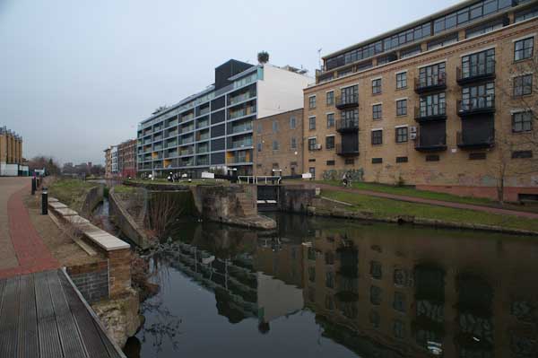
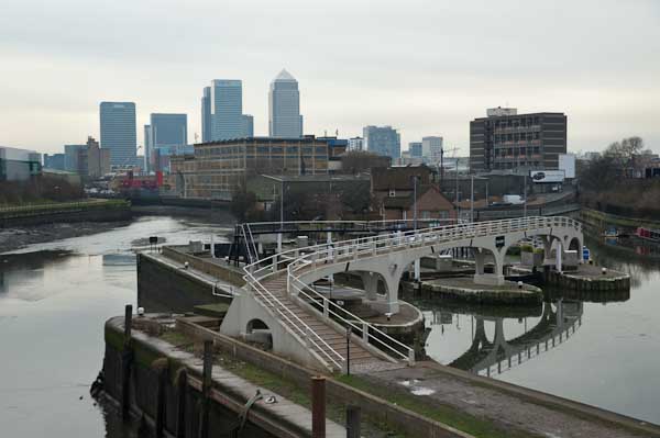
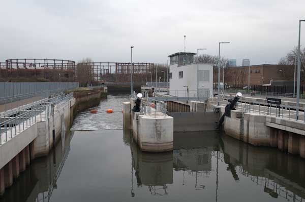
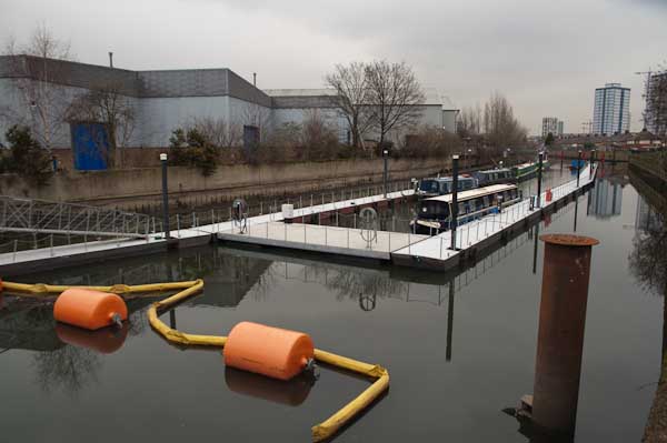
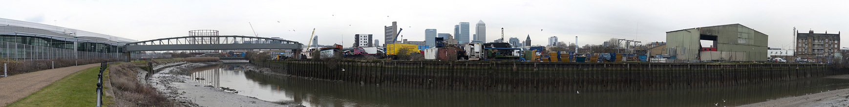
London’s Canal Walk: On Saturday 26th May 2007 I walked across London together with my wife and older son on canal towpaths from Mile End in the east to Old Oak Lane in the west, from where we made the short walk to Willesden Junction for a train towards home.

London's Canal Walk: 2007
There is a great deal of new building next to the Regents canal

I’d walked and cycled along many shorter sections of these canals before, but this was the first time I’d done the whole roughly 12 miles in a single stretch. Most of the way we kept to the towpaths, but there are two tunnels around which we had to detour on roads, and a few places where walking along a road was more convenient than using the tow path, particularly around Little Venice.

London's Canal Walk: 2007
The Hereford Union runs into the Regents Canal in Bethnal Green just beyone here

Probably the definitive book on English canals was written by a photographer, Eric de Maré, (1910 – 2002), one of a now largely forgotten generation of British photographers, and illustrated with many of his fine photographs, as well as some by others. He was one of the finest architectural photographers of the mid-20th century and also someone whose popular Penguin book ‘Photography’ published in 1957 introduced many of us to the history, techniques and aesthetics of the medium. Others since have looked better on the coffee table but have lacked his insight.

London's Canal Walk: 2007
By Cambridge Heath Road, Empress Coaches and the gas holders

de Maré and his first wife lived on a canal boat for some years and travelled around 600 miles along them while writing and taking the pictures for the book ‘The Canals of England’ published by Architectural Press in 1950 which remains the definitive publication on our canals, though in some obvious ways outdated. The canals – which had played an important part in the war effort – had been nationalised under the National Transport Act on 1st January 1948 and part of the book is an impassioned plea for the UK’s transport policies to be revised to update the system and make fuller use of our great canal heritage.

London's Canal Walk: 2007

But of course that didn’t happen, thanks to huge road transport lobby, and instead of canals similar to some in the continent we got motorways. The canals were encouraged to bring commercial traffic to an end, and with a few isolated examples most was finished by 1970 with the canals being given over to leisure use.

Not that de Maré was against leisure use and his work actively promoted this for many of England’s narrow and more rural canals as well as making an argument based on the commercial possibilities of schemes such as the ‘Cross or Four River Scheme’ proposed earlier by a 1906 Royal Commission for wide high volume commercial canals linking Bristol, Hull, Liverpool and London with the Midlands cities of Birmingham, Nottingham and Leicester.

London's Canal Walk: 2007

The book came out in a second edition in 1987 and copies of both are available reasonably priced secondhand – my copy of the first edition with a handwritten dedication from de Maré was at some point marked by a bookseller’s pencil for 6d but I think I paid just a little more. I can find no individual website showing more than a small handful of his pictures – though you can see many by searching for his images online.

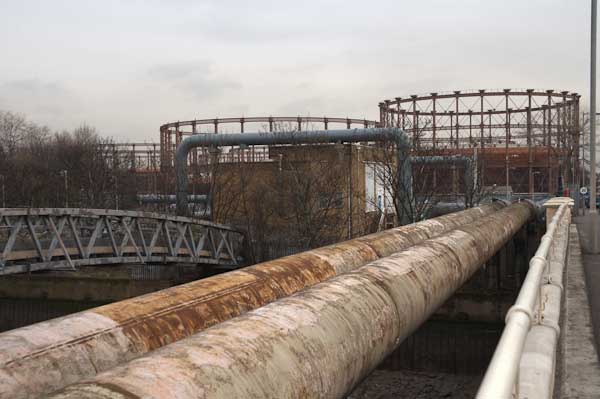
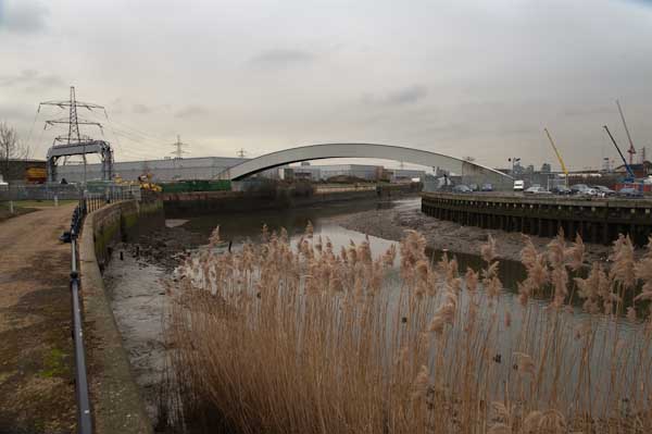
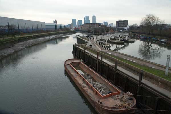
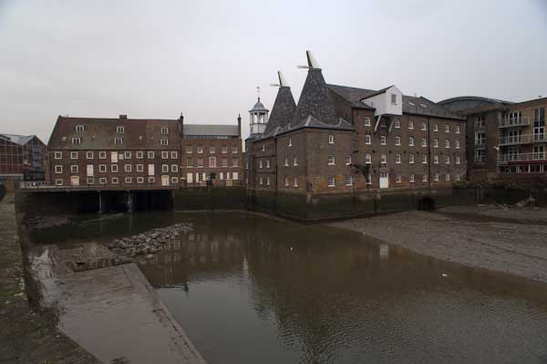
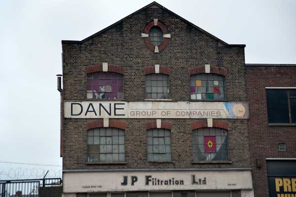
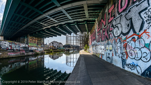
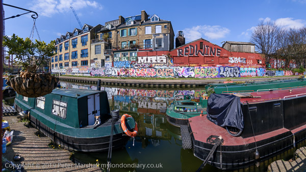
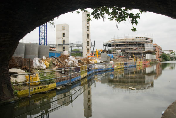
It’s still interesting to walk along by the canals in London, and easy to do in smaller sections – or to add a little at either end should you want to and perhaps walk from Limehouse to Southall or Brentford. I didn’t write much about the walk in 2007, but I’ll end with what I did write back then – with the usual corrections.

On Saturday I accompanied Linda and Sam on a walk along some of London’s canals, from Mile End on the Regent’s Canal and along that to join the Grand Union Paddington Branch at ‘Little Venice’, and west on that to Willesden Junction.

When I first walked along the Regents Canal I had to climb over gates and fences to access most of it. The towpath was closed to install high voltage lines below it, but even the parts that were still theoretically open were often hard to find and gates were often locked. The public were perhaps tolerated, but not encouraged to walk along them.

Now everybody walks along them and there are those heritage direction posts and information boards that I’ve rather come to hate. And from this weekend, you no longer even theoretically need a licence to cycle the paths – though mine is still in my wallet, several years since I was last asked to show it.

Now, as walkers, the constant cycle traffic on some sections has become a nuisance. And although most cyclists obey the rules, riding carefully, ringing bells and where necessary giving way, we did have to jump for safety as one group chased madly after each other, racing with total disregard for safety.

But for the rain – the occasional shower at first, later settling in to a dense fine constant downpour, it would have been a pleasant walk.

Many more pictures on My London Diary


FlickrFacebookMy London DiaryHull PhotosLea ValleyParis
London’s Industrial HeritageLondon Photos

All photographs on this page are copyright © Peter Marshall.
Contact me to buy prints or licence to reproduce.


King’s Cross, St Pancras & Derbyshire

Regents Canal, Granary, Kings Cross Goods Yard, Goods Way, Kings Cross, Camden, 1989 89-5g-61

I left London for a weekend in the middle of May 1989, going up to a conference in Derbyshire, taking the train from St Pancras to Chesterfield and then a bus journey with my family. We had come up to London by train and taken the Underground from Vauxhall to Kings Cross/St Pancras, arriving far too early for the train we had tickets reserved on.

I’m not sure if this was accidental or part of a plan by me to take a short walk and made some pictures before catching the train, but that is what I did, walking up York Road and then down to the Regent’s Canal on Goods Way to make this view across the canal.

Bridge, Granary, Kings Cross Goods Yard, Goods Way, Kings Cross, Camden, 1989 89-5g-63

A little further west on Goods Way I stopped at the bridge over the canal leading to the Granary. As you can see the view of the Granary then was restricted by a number of rather utilitarian buildings on the yard in front of it.

Gasholders, Goods Way, Kings Cross, Camden, 1989 89-5g-64

Further still along Goods Way, the road itself was between tall brick walls but gave a splendid view of the magnificent gas holders, including the fine triplet. I think some of the brick wall at right may remain, covered now in creeper, but on the left side are now new office buildings and no gasholders are in sight, with St Pancras International in their place. It’s a change I still find depressing, though at least the gas holders have been preserved in a new site.

Shops, Pancras Rd, Kings Cross, Camden,  1989 89-5g-65
Shops, Pancras Rd, Kings Cross, Camden, 1989 89-5g-65

I turned left into Pancras Road to take another picture of the block of shops containing the entrance to the Turnhalle (the German Gymnasium) with on one side the St Pancras Cafe and on the corner G Franchi & Sons, Locksmiths and Tools, with two ladders for sale leaning on its frontage.

I think photographers since W H Fox Talbot had always had a bit of a thing about ladders which perhaps made me take another picture of this scene, and I chose also to include the London taxi at left. I will have waited too for the man walking along the street to clear the shop, but as always there were also some elements outside my control.

Intercity train, gasholders, St Pancras Station, Somers Town, Camden, 1989 89-5g-66

Finally it was time to board my train and we were allowed onto the platform where it was waiting. I just had time to walk almost to the end of the platform and made this picture before we left the station.

King's Cross, St Pancras & Derbyshire
Baslow Edge, Derbyshire,1989

We did eventually get to Derbyshire and there was time while we were they for some short walks and I took just a few pictures. The first is I think on Baslow Edge.

King's Cross, St Pancras & Derbyshire
Well, Curbar, Derbyshire, 1989

And this well is in Curbar.


Gasholders, Flats and the Goods Yard – Kings Cross 1989

My posts about my walk around King’s Cross led by the Greater London Industrial Archeology Society on Saturday 8th April 1989 continues. The previous post was Albion Yard and Balfe Street, 1989.

Kings Cross Station, gasholders, Culross Buildings, York Way, King's Cross, Camden, 1989 89-4e-15
Kings Cross Station, gasholders, Culross Buildings, York Way, King’s Cross, Camden, 1989 89-4e-15

We returned to York Way, where I made this picture looking across some of the platforms of Kings Cross Station towards the gasholders. York Way is one of the ancient streets of the area, recorded as Mayde Lane in 1476, later Maiden Lane, and its bridge over the Regent’s Canal is still the Maiden Lane Bridge, though the street became York Rd in the later 219th century.

I wasn’t around when its name was changed yet again to the current York Way in 1938, but for my walks I often made use of large-scale OS maps from previous eras, which provided more information than the street maps or current OS maps. So I sometimes confuse myself and others by still calling it York Rd.

The gasholders have been moved and Culross Buildings and Culross Hall in Battlebridge Rd were demolished around 2004 for the comprehensive redevelopment of the area, so this great piece of urban landscape is no more. The flats built in 1891-2 were home to 150 people.

Battlebridge Basin, Kings Cross, Camden, 1989 89-4f-64

This basin on the Regent’s Canal was made at the same time as this part of the canal was dug in 1820, and some of the buildings around it date from 1822. Originally named for its owner as Horsfall Basin it was later known as Maiden Lane Basin, but later took the original name of the Kings Cross area. The area here had been marshy, and Horsfall contracted to take the spoil from the canal’s Islington tunnel to build up the land around with the basin being used used to bring the spoil.

The area once had a bridge over the River Fleet – underground here since 1825. The river used to run along the west side of Pancras Road. According to legend this is where the the rebel British Celtic Iceni queen Boudicca led an army and defeated the the Romans in AD 60/61, rampaging through much of the south east of England burning towns and settlements though soon after her forces were decisively defeated at Fenny Stratford, near to Milton Keynes.

By the 1970s the basin was unused and many of the industrial buildings around it derelict. In 1978 a group of boat owners formed the non-profit organisation the London Narrow Boat Association and negotiated with on of the factory owners to allow them to moor here.

Both the larger buildings at the right of this picture have since been converted to flats, the taller block as Albert Dock. New buildings including the Guardian newspaper and Kings Place concert hall have replaced some of the old industrial buildings. The former ice warehouse, built around 1860 by ice cream maker Carlo Gatti to store ice from Norway brought here by ship and then canal is now the London Canal Museum.

Midlands Goods Shed, Kings X Goods Yard, Kings Cross, Camden, 1989 89-4f-53

King’s Cross opened as the southern terminus of the Great Northern Railway’s East Coast mainline in 1852, and Midland Railway services from Leicester began to run here in 1858.

Goods traffic was an important aspect of the railway, bringing coal, grain, fish and other goods into London, and a huge area to the north of the station became railway goods yards. It made more for the railways than passenger traffic.

At the time of this walk, proposals for the development of this huge site were being put forward by the London Regeneration Consortium. These were later dropped as plans for the development of the High Speed Rail link changed considerably, and much of the railway lands were used in connection with the construction of this.

After the new Eurostar line into St Pancras International opened in 2007, work began on the redevelopment of the area most of which has now completely changed. Some of the major buildings have been retained and repurposed.

Midland Goods Shed, Kings X Goods Yard, King's Cross, Camden, 1989 89-4m-15
Midland Goods Shed, Kings X Goods Yard, King’s Cross, Camden, 1989 89-4m-15

The Midland Goods Shed was initially built in 1850 as a temporary passenger station while the main King’s Cross station was being constructed. The canopy here was I think a later addition from 1888.

This was in use for many years for handling potatoes and the area to the east was the potato market. In 1989 it was in use for magazine and newspaper distribution.

These listed buildings have been converted into a Waitrose store and cookery school and have retained some of the orginal features.

Goods Offices, Kings X Goods Yard, Kings Cross, Camden, 1989 89-4f-54

These were I think the offices on the front of the Midland Goods Shed and are now looking rather tidier than in 1989

Fish & Coal Offices, Kings X Goods Yard, Kings Cross, Camden, 1989 89-4f-56

This group of buildings are on the edge of the Regent’s Canal, and tower above it when you walk along the towpath below. They are now in much better condition and a part of the Coal Drops Yard reformation of the area.

Built from 1851 to 1862, although these are unlisted they were scheduled to be retained and refurbished in the development proposals.

The Granary, Kings X Goods Yard, Kings Cross, Camden, 1989 89-4f-41

The most impressive of the buildings on the goods yard site, the Grade II listed Granary was purpose-built to designs by Lewis Cubitt to store grain and flour in 1852 as a part of the original plans for the station. It was built to store around 5,000 tons of grain and had hydraulic lifts for the sacks of grain. The granary also used to have two short canals from the Regent’s canal to its basement as well as an open dock.

The Granary, Kings X Goods Yard, Kings Cross, Camden, 1989 89-4f-55

The Granary is now home to Central Saint Martins – University of the Arts London.

Our exploration of the Goods Yard will continue in a later post.

The first post on this walk was Kings Cross, St George’s Gardens & More.


An East London Ride – 2010

Salmon Lane Locki, Regents Canal

It’s perhaps misleading to call this a ride, since I spent most of the day on Wednesday 3rd February 2010 actually off my bike, parking it neatly to take photographs. Although a bicycle has been my main personal transport now for over 70 years (when I’m not using public transport or walking) I’m not really a cyclist. Or at least just a pragmatic cyclist, using a bike just to get from A to B (and on this day to C,D and most of the letters of the alphabet.)

An East London Ride - 2010
Memorial to firewatchers of Stepney Gas Works

And just very occasionally for a bit of exercise. I have used exercise bikes and always thought why bother when you could use the real thing, though I suppose when its pouring with rain or below zero there might be some point in them. And though one wouldn’t help me to take photographs I would be less likely to be killed by careless or dangerous drivers.

An East London Ride - 2010
Bromley-by-Bow gasholders, Twelvetrees Bridge

Back at the end of 2002 I bought myself a Brompton folding bike, and a year or three later when I was undergoing a Q & A interview for an amateur photography magazine it became my answer to ‘What is your most useful photographic accessory’. It had replaced the answer to a similar question from another such magazine which was ‘a good pair of shoes’.

Eternal flame, West Ham Memorial Gardens

Once you have practised a few times the Brompton folds (and unfolds) in a few seconds into a fairly compact package, which has the advantage you can take it at any time onto our trains and underground system. It’s too heavy for me to comfortably carry any distance, but I added the tiny wheels which mean you can pull it rather like a suitcase, only actually lifting it when necessary. And I bought the bag which fits on in front of the handlebars which was about the right size for my camera gear and essentials like a bottle of water or a flask of coffee and sandwiches.

The end of the ‘Fatwalk’

I can’t know remember exactly how I got to the start of my ride, though I think I probably rode from Waterloo to Fenchurch Street for a train to Limehouse station, crossing the Thames on Southwark Bridge. But from there on the pictures make my route fairly clear.

Bow Creek and Bow Locks

I cycled roughly along the Regents Canal up to the former Stepney Gas Works site north of Ben Johnson Road. There had been a fight to save more elements of the former gas works including gas holders which were some of the oldest surviving in the world; although some were said by English Heritage to be of national importance an attempt to get one of them listed failed. Eventually the area was redeveloped by Bellway Homes with only token ‘public art’ residues of the works.

From there I headed east to the bridge at Twelvetrees Crescent across Bow Creek and the Lea Navigation to visit another gas works site, the West Ham Memorial Gardens where war memorials, a permanent flame and a statue of Sir Corbett Woodhall are in a small wooded area close to the remarkable group of gas holders for the former Bromley-by-Bow Gas Works.

Three Mills

From there I went down to the recently opened path beside Bow Creek, part of a planned riverside walk which had been landed with the ridiculous name of The Fatwalk. As I commented then, most of the walk, meant to lead from Three Mills all the way to the Thames was still closed (and is still closed 13 years later) and by the time they were open the “nincompoop who thought that ‘The Fatwalk’ was a good name for this route will probably have retired or died or moved to another job for which he (or she) is equally incapable and common sense will prevail as we walk or cycle along the Bow Creek Trail.”

New Lock, Prescott Channel

The walk still only goes as far south as Cody Dock, now a thriving community resource and hub with events and exhibitions and worth a visit, but in 2010 still undeveloped. The silly name has gone and this path is now also a part of London’s sculpture trail, The Line, making its way from the Greenwich Peninsula to Stratford.

Three Mills Wall River

At the end of the Fatwalk, I had to turn around and go back to the Twelvetrees Crescent bridge, where I once again photographed the locks from the Lea Navigation to Bow Creek. Now there are new steps leading down from this bridge to the towpath, but then I had to go across and join the fast-moving traffic on the Blackwall Tunnel Northern Approach to make my way to Three Mills.

Stratford High St

Three Mills is home to one of Newhams only four Grade I listed buildings and the House Mill, a tide mill, was built in 1776, though there had been tide mills here at least since the Domesday book.

Olympic stadium

The film studios here were converted from a gin factory where Chaim Weizmann developed a new biochemical process to produce acetone needed for explosive production in the First World War – which led to the Balfour Declaration and later to Weizmann becoming the first president of Israel.

Bridge over City Mill River

Past the studios I visited the new lock on the Prescott Channel, opened in 2009. Supposedly this was to be used by barges to carry away waste and bring in material for the development of the Olympic site instead of lorries, but was in practice only used for photo-opportunities. The Prescott Channel was built in the 1930s, part of a large flood relief programme, that was also largely to provide jobs at the height of the depression.

I get interviewed for a student film

Finally I cycled up to the Olympic site, a building site with little or no public access, but parts of the ‘Greenway’ – the path on the Northern Sewage Outfall – were still open and gave extensive views. The reason I was in London on this particular day, when the weather wasn’t at its best was to be interviewed and filmed by a group of students at the View tube on the Greenway. I can’t remember ever seeing the video. After the interview I made my way to Stratford to fold the Brompton and start my journey home on the Jubilee Line.

Bow Creek – right click to open at a viewable size in a new tab

As well as taking single images I also produced a number of panoramas, taking a series of pictures from the same position to be stitched together. These include some 360 degree views, produced by software from 6 or 8 individual images. The pictures were taken on a Nikon D700 and are each 12Mp, but the combined files are huge. It isn’t easy to display these on the web, and they fit even less well on this blog. I’ll post one here on a rather smaller scale and invite you to double click on it to see it larger, though still much reduced. You can find more online here.

Olympic Site Revisited
Three Mills
Bow and The Fatwalk


Tottenham, Hackney and The Times

I took the Underground to Seven Sisters, pausing while I waited for a bus to take a few pictures of the shops that would be lost with the redevelopment of the ‘Latin Village’ along with that thriving indoor market. For once I had a clear view from the bus and I took a few pictures as it made its way north to Tottenham job centre. I arrived earlier than expected and walked on the short distance to Tottenham’s new ground, officially opened the previous week, before walking back to photograph the protest I had come for.

The stadium did seem quite impressive from the outside, though like many others I was less impressed to hear that the football club are keen to pay TfL to change the name of the railway station in White Hart Lane to ‘Tottenham Hotspur’. I’m pleased to see that it still has its old name now, 149 years after it opened with it. Spurs wanted the change because it would increase the chances of finding a sponsor for the new stadium, but there was considerable opposition. And while there is precedent – Gillespie Road on the Picadilly line was renamed Arsenal in 1932 – since that team has now moved from their old ground it perhaps wasn’t a good idea.

The protest outside the Tottenham Jobcentre Plus was organised by the North London Revolutionary Communist Group and others and was one of many that have been taking place regularly outside job centres calling for Universal Credit to be scrapped. UC was badly thought out but even more poorly implemented, both thanks to Iain Duncan Smith, Secretary of State for Work and Pensions from 2010 to 2016. Designed both to rationalise and cut benefits, it incorporates a delay typically of five weeks between the old benefits ceasing and UC being paid, leaving many with nothing to live on. Some minor improvements have been made, including the availability of loans, but those on benefits are not really in any position to repay loans. Together with a harsh benefits sanction regime which had meant some claimants have lost benefits for long periods for relatively trivial reasons – such as being a few minutes late for an appointment – or having an accident on the way to one, this has resulted in a huge growth in reliance on food banks and even some deaths due to starvation and being unable to heat homes. Many have been forced into huge rent arrears – and in 2018 one in 38 of new claimants became homeless because of evictions.

The campaigners were still handing out leaflets and talking to clients going into the job centre and leaving when I caught the bus to make my way down to Bethnal Green. The weather, with sun, blue sky and some clouds was perfect for continuing my project making panoramic images of the Regent’s Canal in preparation for a show to celebrate the 200th anniversary of its opening in 1820.

As well as pictures showing the canal I took a few more on my way to Bethnal Green, as well as walking around the area, then along the canal west to Broadway Market.

It was then time to get on a bus again, to make my way to the offices of News Corp at London Bridge, where Transmission, a group supporting the rights of trans people, were protesting outside the offices of The Times newspaper against their publication of transphobic articles.

They say the paper has published an unfair article by Lucy Bannerman against the Tavistock Centre and medical services for trans children and has earlier targeted the trans charity Mermaids and ostracised trans athletes for competing in sports.

More on My London Diary:
Times end transphobic articles
Regent’s Canal
Scrap Universal Credit Jobcentre protest
Tottenham and Spurs

January 1987 continued

Regents Canal, Gloucester Ave, Primrose Hill, Camden, 1987 87-1c-22_2400
Regents Canal, Gloucester Ave, Primrose Hill, Camden, 1987

think I had a good month taking pictures in January 1987. I always liked the winter months for photographing places, although the weather wasn’t always kind. But London is a city of many trees, and though they enhance it greatly they also obscure many views. And I do like the way you can see the structure of the trees after they have shed their leaves for the winter, though perhaps they are at their best in spring as they begin to sprout again.

Most of the month I was in Camden, and walked a little beside the Regent’s Canal as it goes through Primrose Hill. There were just a few boats moving – the canals were less busy back then. I’ve always had an interest in the canals in London – and this year was to have exhibited a set of panoramas to celebrate the 200th anniversary of the Regent’s Canal, officially opened in August 1820. You can read more about that show which had to be abandoned in an earlier post here, and the set of pictures I took in preparation for it are – including the one from Camden below – are on Flickr.

Regents Canal 2020: Camden High St13-20190308-d0708
Regent’s Canal, Camden, 2019 – from ‘Regents Canal 200’
Primrose Hill, Camden, 1987 87-1c-51_2400
Primrose Hill, Camden, 1987

One of my favourite portraits is Bill Brandt’s 1963 photograph of a rather morose Francis Bacon looking out of the left of the frame at twilight in front of a lamp post on Primrose Hill. Of course my picture is nothing like his, an empty path and rather more naturalistic, but I think it captures something of the atmosphere of the place which attracted Brandt and made him choose it as a suitable stage for his picture.

Sir John Soane, memorial, Old St Pancras Burial Ground, Pancras Rd, Camden, 1987 87-1d-15_2400
Sir John Soane memorial, Old St Pancras Burial Ground, Pancras Rd, Camden

Sir John Soane (1753-1837) was a leading British architect working in a neo-Classical style. Although prolific, many of his buildings have been demolished or, like the Bank of England, greatly remodelled, though his three London churches, St Peter’s Walworth, Holy Trinity Church, Marylebone and St John, Bethnal Green remain, as does the Dulwich picture gallery and work at various stately homes.

His family tomb in the Old St Pancras churchyard, designed the year after his wife’s death in 1815 is perhaps the most clear example of his work, and is said to be the inspiration behind Giles Gilbert Scott’s red telephone box, made in 1924 shortly after Scott had been made a trustee of the Soane Museum in Lincoln’s Inn Fields – possibly London’s best and certainly one of its quirkiest museums.

Fence, Grafton Rd, Gospel Oak, Camden, 1987 87-1h-14_2400
Fence, Grafton Rd, Gospel Oak, Camden, 1987

I made several exposures of this short alley in Gospel Oak, beside a tall fence partly covered by dead creeping plants. and with a rectangular block behind. Fortunately fairly early on a Sunday morning in January there were few passers-by to doubt my sanity and I didn’t have to wait long for the passageway to be empty.

The barriers, the fence and the building each define planes with rectangular blocks at different angles – with both creeper and clear space roughly defining rectangles at an angle, and through that space the rectangle of the building seemed to me to match that of the barrier on the footpath.

Gilden Crescent, Kentish Town, Camden, 1987 87-1g-46_2400
Gilden Crescent, Kentish Town, Camden, 1987

You could furnish a home from the street in front of this shop selling (and buying) “All types of Old & Modern Furniture” and of course many did. We still use the chairs we carried home from a shop like this, and a few other pieces of furniture, though we had our own photographs of ancestors for the wall rather than buy those on display.

But other things too attracted me about this display as well as the neat rows of chairs, the mattresses and the gas cookers. There was the antique lamp post in the middle of the display at right, and, above the door, presumably from an earlier use, the advertisement in lieu of a shop name ‘WEIGHTS Cigarettes… For More Pleasure.”

Hockey, St Leonard's Square, Kentish Town, Camden, 1987 87-1i-46_2400
Hockey, St Leonard’s Square, Kentish Town, Camden, 1987

Two house bricks stand as a goal for these boys playing roller hockey on quad skates in a cul-de-sac in Kentish Town. I think it was a sport I had not met before – and those hockey sticks were made in the USSR.

Hockey Players, Holmes Rd, Kentish Town, Camden, 1987 87-1j-41_2400
Hockey Players, Holmes Rd, Kentish Town, Camden, 1987

A short walk away I came across another group of hockey players, standing with large sports bags and hockey sticks next to a mural showing roller hockey players on the wall of a skate shop. Their bags and sticks say ‘CANADIEN’ . I can’t remember now what they told me, and whether or not they were Canadian.


All photographs on this and my other sites, unless otherwise stated, are taken by and copyright of Peter Marshall, and are available for reproduction or can be bought as prints.