Memorials, Eros and More: On Sunday 15th October 1989 I caught the North London Line from Richmond to Highbury & Islington for the start of another walk in North London.

There had been a series of conflicts between Dutch and British settlers in South Africa for some years as the Boers opposed the British annexation of African countries and resented British attempts to end slavery. The first Boer War in 1880-1 ended badly for the British who signed a peace treaty with Transvaal President Paul Kruger.
But the discovery of huge gold reserves in 1884 created a hug British interest in the area, and Britain again decided to try to take control of Transvaal and the Orange Free State. One of the earliest moves was a failed attempt thought up then by Cape Prime Minister Cecil Rhodes and Johannesburg gold magnate Alfred Beit to provoke an uprising in Johannesburg by an armed raid from Rhodesia, the Jameson Raid over the New Year in 1896. This was followed by an uneasy truce – and an uprising by the Matabele and Mashona peoples against the British South Africa Company whose forces had been greatly weakened by taking part the raid which was suppressed with many Africans killed.
British efforts continued and in 1899 after Britain rejected an ultimatum to withdraw their troops made by Kruger he declared what we generally call the Boer War, though now more widely known as the South African War, which continued until 1902.
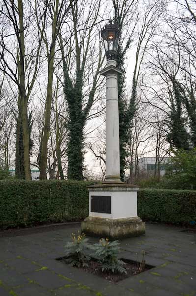
The memorial was erected here in 1905 and the inscription reads:
HOW SLEEP THE BRAVE WHO SINK TO REST
BY ALL THEIR COUNTRY’S WISHES BLESS’D.
IN HONOUR OF
NINETY-EIGHT ISLINGTONIANS
WHO DIED FOR THEIR COUNTRY
IN THE SOUTH AFRICAN WAR,
1899 – 1903.
ERECTED BY THEIR FELLOW-TOWNSMEN
JULY 1905.
as well as listing the names of the 98.
The war had repercussions and laid the basis for apartheid in South Africa. It also saw the first ‘concentration camps’ where Boers were imprisoned by the British. And Robert Baden-Powell who had been a scout in the war set up the Scout movement with a uniform and ideas based on his role there.
On the wall behind the cannons is the graffitied message ‘BRITISH STATE HEAR US SAY – IRISH PEOPLE WILL MAKE YOU PAY.

This gate to The Court Gardens is, perhaps unsurprisingly, next to Highbury Corner Magistrates’ Court on Holloway Road, which perhaps accounts for the uncompromising concrete wall at right. Underneath the name it states PRIVATE PROPERTY. A private road leads into the housing in Court Gardens from Liverpool Road,

Thomas Judd, Memorial & Marble Masons remained in this shop until around 2018. The shop had been open since the 1880s and was thought to have been the oldest business in continuous use on the street.
The Camden New Journal reported in 2018 that its owner, Kenneth Howard, was an 81 year-old who had retired and in 2016 had been suspended from the National Association of Memorial Masons register for a year. This meant the company was unable to work in many cemeteries. He was taken to court by some clients who had paid deposits to him for work he had been unable to deliver, claiming he had been let down by a sub-contractor, and was ordered to pay back the deposits with compensation, court costs and a victim surcharge.

This company is still in existence but moved its registered office from 11 Ronalds Road in 2014 to Hertford and their name across the adjoining gates was replaced the following year by NET.WORKS.LONDON and later by UNCOMMON as serviced offices.
Although the neighbouring former Salvation Army Citadel is locally listed I was a little surprised to find this building is not mentioned.It is well-proportioned with fine doorways.

According to the fine ‘Streets With Story’ by Eric A Willats, Ronalds Road was named “after Sir Francis Ronalds (1788-1873) who was, with Wheatstone, one of the pioneers of the electric telegraph. The name was suggested by a Mr. M.C. Sharpe who for years had lived at Highbury Terrace. Sir Francis’s father Francis Ronalds took over no.1 Highbury Terrace in 1796 and died in 1806. The new road had run alongside no.1 and the first electric wires ran from a coach-house of no.1 to a cottage in the immediate neighbourhood.”
Ronalds (1788 – 1873) built the world’s first working telegraph system in his mother’s back garden in Hammersmith when he was 28 in 1816. ‘It was infamously rejected on 5 August 1816 by Sir John Barrow, Secretary at the Admiralty, as being “wholly unnecessary“.’

I think this fence and yard has long disappeared together with the figure on it, but is was possibly part of Drayton Park School close to the corner of Arvon Road. I think the picture shows a child holding something just above kitchen scales.

Much of this section of Hornsey Road close to the impressive Victorian School building at 30-36 has been replaced by modern buildings since 1989 and I think that the building that Eros Fashions occupied has gone. Certainly I can find no trace of it now.
Back then Eros Fashions was still in business, with vacancies for almost everyone involved in the manufacture of clothing:
“VACANCIES
MACHINISTS
FINISHERS
PRESSER
OVERLOCKERS
FELLING
CUTTER“
on the board beside the door, and shadowy mannequins inside.
This is the final picture in my book ‘1989’ still available on Blurb, though at a silly price for the print version, and the full set of pages is on the web site, including this image and this text:
“‘Eros, fairest among the deathless gods, who unnerves the limbs and overcomes the mind and wise counsels of all gods and all men within them.’
Created first out of Chaos, also son to Aphrodite, though argument rages as to whether his Dad was Zeus, Ares or even Uranus.
It must be a bit of a come-down to be running a fashion manufacturer (to be rude you could call it a sweat-shop) in North London. Though he was always a bit of a shady character – those different names for a start – Cupid and Amor – what was he trying to hide? And then there’s that business with Hymen, best not to say too much.”‘”
Which seems a suitable place to end this post, though my walk will continue in further episodes.
Flickr – Facebook – My London Diary – Hull Photos – Lea Valley – Paris
London’s Industrial Heritage – London Photos
All photographs on this page are copyright © Peter Marshall.
Contact me to buy prints or licence to reproduce.