Posts Tagged ‘Lea Navigation’

Around High St Stratford

Tuesday, January 19th, 2021

St Thomas's Creek, Cook's Road, Stratford, Newham, 1983 35q-34_2400
St Thomas’s Creek, Cook’s Road, Stratford, Newham, 1983

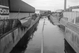
There is and long seems to have been some confusion about the naming of this part of the canal system that links the main line of the Lea Navigation at Bow Bridge to the City Mill River and City Mill Lock. On some maps (including Google’s) it is simply referred to as ‘Bow Back Rivers’ but I find it less confusing to give it the more local name, St Thomas’s Creek, sometimes written as St Thomas Creek. The creek got its name from St. Thomas’s Mill, sometimes called ‘Pudding Mill’, I think because of its shape, which also gave its name to the small stream the Pudding Mill River and was actually on that stream on Pudding Mill Lane. For those interested there is a good map of the area before the flood relief works of 1931-5 on British History Online.

Yardley's Box Factory, Stratford High St, Stratford, Newham, 198336m-63-positive_2400
Warton House, former Yardley’s Box Factory, High St, Stratford, 1983

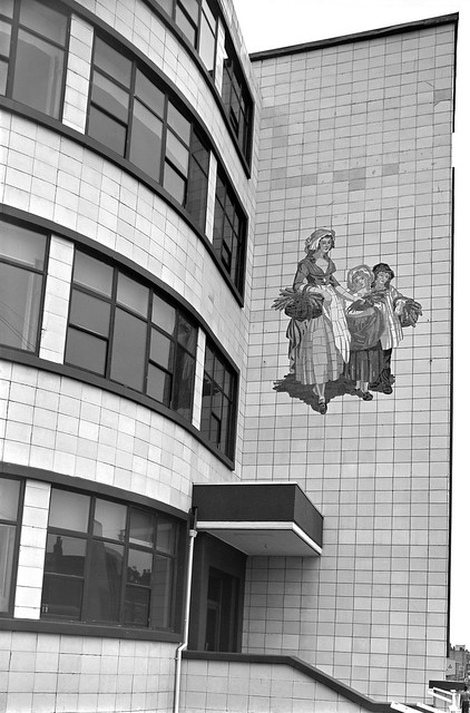
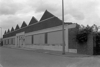
The earliest connection of the Yardley name to soap-making was in the first half of the 17th century, when a Yardley was given the concession to produce soap for the whole of London, but the company dated its founding as ‘Clever Brothers’ to 1770. This company making soaps and perfumes was taken over by William Yardley in 1823 and passed on to his son Charles when he died the following year. The company moved from Bloomsbury to a large factory on Carpenters Road Stratford in 1904 and bought land on Stratford High St in 1918. In 1913 they had trade-marked a picture by Francis Wheatley from his 1793 series, the ‘Cries of London’ to use in their advertising, replacing the primroses in his picture by lavender, and when they built a new art deco box factory in 1938 this was installed at a large scale on the building. Yardleys moved to Basildon in 1966, needing large premises, but in 1967 were taken over by British American Tobacco who sold the business to Beecham in 1985, who again sold it on after they merged to be SmithKlein Beecham. The company went into receivership in 1998. Parts of the box factory – including this section on the High St next to the Northern Outfall Sewer and the Waterworks River are still there, all that is left of Yardley’s in Stratford.

Stratford High St area, Stratford, Newham, 1983 36m-14_2400
Stratford High St area, 1982

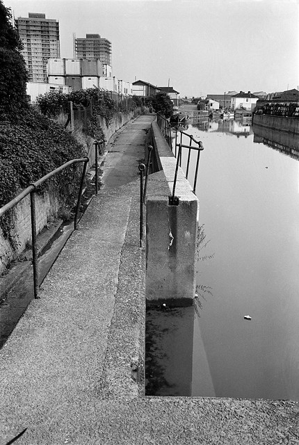
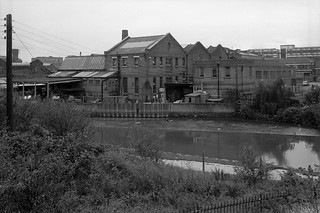
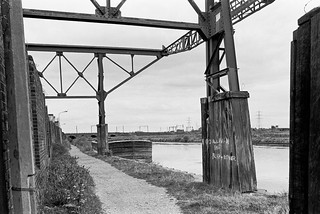
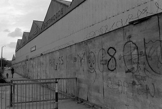
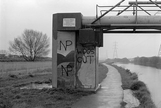
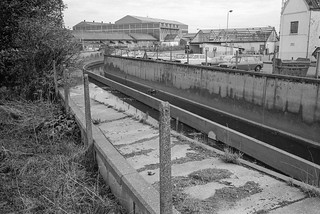
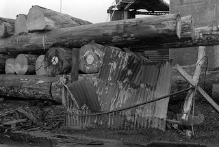
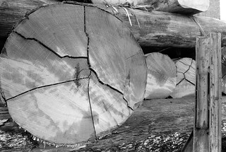
I cannot remember exactly where I took this or the next picture, though from other exposures on the same films both are clearly somewhere not far from Stratford High St. I think the canal seen at right here is probably St Thomas’s Creek.

Timber yard, Stratford, Newham, 1982 32v-22_2400
Timber yard, Stratford High St area, 1982

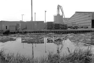
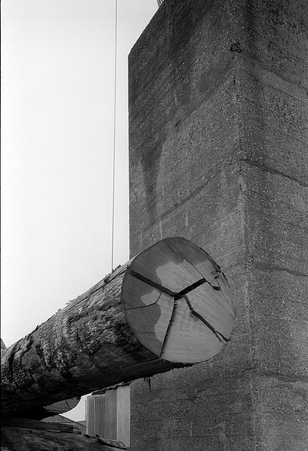
Timber was the main product carried on the Lea Navigation in the later years of its use, and I think this timber yard was probably close to the main stream of the navigation. My attempts to find it again in later years were unsuccesful.

Cafe, Stratford market, Stratford, Newham, 1983 36p-35_2400
Cafe, Stratford market, Stratford, Newham, 1983

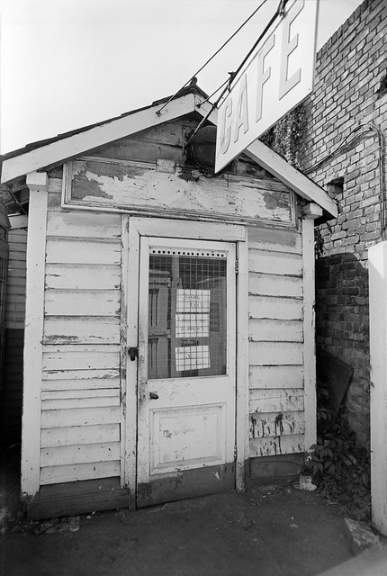
The notices on the door offer not just ‘Jellied Eels’ but ‘Best Jellied Eels’, along with ‘Loch Fine Kippers’. My contact sheet puts its location as Stratford Market in Burford Road, just off High St to the south.

Barge, Lea Navigation, Bow Bridge, Bow Flyover, Tower Hamlets, Newham, 1981 29t-26p_2400
Barges, Bow Bridge, October 1981

These last two pictures were some of the first I took in the area after I heard on a radio interview that commercial traffic on the Lea Navigation was to come to an end in a few weeks time.

I think it was the same day that I picked up my camera bag and got on the train to come to look for and photograph any remaining activity. It was a slow journey to Bromley-by-Bow from where I spent an hour or so walking along beside the navigation between Bow Locks and Bow Bridge, where I found three barges loaded with cut timber, photographing all three from the bridge and going down onto the wharf for another picture.

Barge, Lea Navigation, Bow Bridge, Tower Hamlets, Newham, 1981 29t-25_2400
Barges, Bow Bridge, October 1981

I find it hard now to understand why I took so few pictures – only around 30 exposures on the entire visit, and just these two where I found evidence of any remaining commercial traffic.

More pictures from the area on page 3 of my Flickr album River Lea – Lea Navigation 1981-1992.


All photographs on this and my other sites, unless otherwise stated, are taken by and copyright of Peter Marshall, and are available for reproduction or can be bought as prints.


City Mill Lock & Blaker Rd

Thursday, January 14th, 2021

City Mill Lock, Blaker Rd,  Stratford Marsh, Stratford, Newham, 1990 90-9f-32 (2)_2400
City Mill Lock, Blaker Rd, Stratford Marsh, Stratford, Newham, 1990

City Mill Lock connected the tidal Waterworks River with the Bow Back Rivers which are a part of the Lea Navigation and thus at a constant level. There is another lock connecting the two systems further north where Carpenters Lock connects the Old River Lea to the start of the Waterworks River close to Carpenters Road. Both locks were built in the 1930s when considerable work was carried out, mainly to reduce flooding but also with the intent of increasing commercial traffic on the Back Rivers, particularly the City Mill River. But I think this never happened and by the 1960s these streams were seldom if ever used.

City Mill Lock, Blaker Rd,  Stratford Marsh, Stratford, Newham, 1983 36m-35_2400
City Mill Lock, Blaker Rd, Stratford Marsh, Stratford, Newham, 1983

The River Lea was at least theoretically navigable at the right stage of the tide some way further north – and of course much further by kayaks, though there are legal restrictions on parts of its many streams.

Since the Olympics, the tidal flow on the river has been regulated by a new lock on the Prescott Channel at Three Mills which I photographed in 2010. The original intention of British Waterways that the river above this point should be non-tidal but its level still varies, perhaps simply with the river flow.

City Mill Lock, St Thomas's Creek, Stratford Marsh, Newham, 1983 36m-22a-positive-2_2400
City Mill Lock, St Thomas’s Creek, Stratford Marsh, Newham, 1983

The lock gates had clearly seen rather better times and the lock was unusable. These gates were replaced as a part of the makeover of the area for the Olympics.

City Mill River, Stratford Marsh, Stratford, Newham, 1983 35v-15_2400
City Mill River, Stratford Marsh, Stratford, Newham, 1983

Just to the west of the lock, behind the lock keepers house, St Thomas’s Creek turns towards the north and becomes the City Mill River. A few boats were moored here, next to Blaker Rd.

City Mill River, Blaker Rd,  Stratford Marsh, Stratford, Newham, 1983 35v-13_2400
City Mill River, Blaker Rd, Stratford Marsh, Stratford, Newham, 1983

Continuing north beside the City Mill River along Blaker Road led to a footpath which went under the Northern Outfall Sewer in a tunnel. It was possible to access the Greenway walkway on the sewer from here.

City Mill River, Blaker Rd,  Stratford Marsh, Stratford, Newham, 198335v-26_2400
City Mill River, Blaker Rd, Stratford Marsh, Stratford, Newham, 1983

From where you could look down on the path and the railings beside the river.

City Mill River, Stratford Marsh, Stratford, Newham, 1983 35v-25_2400
City Mill River, Stratford Marsh, Stratford, Newham, 1983

This is the view looking back down the City Mill River towards City Mill Lock, now rather different.

City Mill River, Railway, Stratford Marsh, Newham, 1983 36m-43

The footpath led on past the Northern Outfall Sewer to a rather strangely angled basin taking the river under the main railway lines. From here you could continue walking beside the river and eventually reach the north end of Marshgate Lane and Carpenters Road.

The last time I tried to repeat this walk, in 2019, it was not possible, with work still taking place in the area and fences stopping me. As well as work still taking place after the 2012 Olympics, parts were blocked by work on Crossrail.

More pictures on Flickr.


All photographs on this and my other sites, unless otherwise stated, are taken by and copyright of Peter Marshall, and are available for reproduction or can be bought as prints.


Stratford Marsh: Sewage and Rivers

Thursday, January 7th, 2021

Northern Outfall Sewer, Lea Navigation, Stratford Marsh, Newham, 1983 36o-24_2400
Two pipes and behind them the Northern Outfall Sewer

Part of Bazalgette’s great plan for freeing the Thames in central London from being a huge open sewer was to build large sewage pipelines to sewage works to the east of London. North of the river, the Northern Outfall Sewer, built in 1960-65, channels sewage from high level sewers serving North London and those from Central London to run under an embankment from Wick Road, across the Lea Navigation at Old Ford and past Stratford’s ‘Cathedral of Sewage’ at Abbey Mills which pumps up sewage from lower level sewers serving West London to join it and flow together to the sewage works at Beckton, the effluent from which is discharged into the Thames. Above the large pipes is a path for pedestrians and cyclists, rebranded at great expense as ‘The Greenway’ in the early 1990s.

Lea Navigation, Stratford Marsh, Newham, 1983 36o-34_2400
These two pipes close to the Greenway are perhaps for gas.

It provides a useful traffic-free route across Newham, but access to it is often poor, particularly for cyclists and for the past 15 or so years has been blighted by closures of various sections, particularly in Stratford Marsh for the 2012 Olympics and Crossrail construction as well as sewer maintainance. It should be open again now and is an interesting walk, though the slightly sweet sickly smell may put some off.

Towards Bow, from Northern Outfall Sewer, Stratford Marsh, Newham, 1983 33x-14_2400
Stratford Marsh and Bow, 1983
Lea Navigation from Northern Outfall Sewer, Stratford Marsh, Stratford, Newham, 1990 90-9h56_2400
The sewer path provides an elevated viewpoint. Lee Navigation and Bow 1990

Stratford Marsh north of the Northern Outfall was bounded by water. The Old River Lea ran from Carpernters Road through Carpenter’s Lock to join the Lea Navigation just south of Old Ford Lock and immediately north of the outfall. Along its east side was the Waterworks River (carrying most of the flow from the Lea and passing under the sewer close to Stratford High St, which it flowed under close to City Mill Lock. Running West from the other end of the lock was St Thomas’s Creek joining to the Navigation at Bow Bridge, and north the City Mill River linking to the Old River Lea.

City Mill River, Stratford Marsh, Newham, 1983 35p-24_2400
A rare boat makes its way around the Bow Back Rivers. City Mill River, 1983

Until the closure for the Olympics it was possible for boats to navigate around the area, leaving the navigation just above Bow Bridge on St Thomas’s Creek, going north up the City Mill River, then west along the Old River Lea back to the navigation, all these rivers being at the same level. In quite a few days of walking around the area I only saw two boats making the trip.

Signal Box, Stratford Station, Stratford, Newham, 1983 35p-65_2400
Channelsea River at Stratford Station, 1983

Another smaller channel, the Pudding Mill River, ran a little to the west of this down from the Old River Lea, disappearing under the railway lines which cut through Stratford Marsh (a couple of pictures in a later post.) This river I think disappeared completely under the stadium in the Olympic makeover; while all around them was changed (including the soil, much imported from elsewhere) the other watercourses in this area emerged largely unscathed though there were changes south of the High St, and I think the Channelsea River was possibly further marginalised.

Channelsea River, Jupp Rd, Stratford, Newham, 1983 35p-62_2400
Channelsea River, Jupp Rd, Stratford, 1983

Fish Island, Hertford Union & Old Ford

Sunday, January 3rd, 2021

Roach Road, Old Ford, Tower Hamlets, 1990  90-9h24_2400
Roach Rd, 1990

The Hertford Union Canal is a short canal which links the Lea Navigation at Hackney Wick to the Grand Union Canal in Bethnal Green, and so to the canal system across England and Wales. Just across the canal at the south of Hackney Wick was a largely industrial area with several street names – Dace Rd, Roach Rd, Bream St – gave it the name ‘Fish Island’. Always somewhat isolated with canals on two sides of a triangle, it became even more so with the building of the A12 East Cross Route effectively severing it on the third side. A new footbridge across the Hertford Union now makes it more accessible from Hackney Wick.

Hertford Union Canal, Hackney Wick, Tower Hamlets, 1983 36n-31_2400
Hertford Union, Fish Island, 1983

There were several timber yards along the Hertford Union, some still at work in the 1980s, although no longer served by the canal.

Hertford Union Canal, Hackney Wick, Tower Hamlets, 1983 36n-32_2400
Herford Union, 1983

There were still a few barges moored at some wharves in 1983.

Hertford Union Canal, Hackney Wick, Tower Hamlets, 1983 36n-34_2400
Hertford Union , 1983

Though most of the wharves – like this one with a roof extending over the canal – were empty. There were no boats moving on the canal when I walked beside it, and little wind to disturb the reflections.

Isle of Dogs Youth, Hertford Union Canal, Old Ford, Tower Hamlets, 1983 36n-24_2400
Hertford Union , 1983

I’d seen the boat belonging to the Isle of Dogs Youth project moving on the Lea Navigation, but here it was moored, I think outside about the only former industrial building along the whole length of the canal which has not been replaced by flats, the Chisendale works, built in 1942-3 by Maurice Cohen as a factory, CHN Veneers, to glue together layers of wood to make parts for fighters and bombers, including Spitfire propellors. The factory closed in 1972 and was bought by Tower Hamlets Council and left empty. In 1980 they leased it to artists who had been evicted from Butlers Wharf close to Tower Bridge. It took them two years of work to clear the building and make it useable with two dance studios, 40 artists workshops and a public gallery as Chisenhale Art Place.

Hertford Union Canal, Old Ford, Tower Hamlets, 1983 36n-22_2400
Hertford Union, 1983
A F Suter & Co, Swan Wharf, Dace Road, Old Ford, Tower Hamlets, 1990  90-9h35_2400
Dace Rd, 1990

A F Suter & Co’s building at Swan Wharf is in Dace Road at the south east of Fish Island, close to Old Ford Lock on the Lea Navigation.

Mural, Wick Lane, Bow, Tower Hamlets, 1983 36o-31_2400
Mural, Wick Lane, 1983

Wick Lane is one of two roads which lead out from Fish Island, both along its west edge, with Wansbeck Rd leading north to Hackney Wick and Wick Lane taking you across the East Cross Route to Bow. Pedestrians can also leave by crossing the Lea Navigation at Old Ford Lock or on the Northern Outfall Sewer (aka Greenway) or a footbridge across the East Cross Route to Old Ford.

All these pictures are in my Flickr album River Lea – Lea Navigation 1981-1992. You can also find them with other later pictures of the area on my web site: River Lea/Lee Valley.


All photographs on this and my other sites, unless otherwise stated, are taken by and copyright of Peter Marshall, and are available for reproduction or can be bought as prints.


Hackney Wick (1)

Friday, January 1st, 2021

Waterden Rd, Hackney Wick, Hackney, 1982 32z-65_2400

Thinking about the New Year – or about the past one – simply makes me feel angry and depressed, and though I started to write something I couldn’t finish it. There is plenty of stuff already on the web and in print about it. So I decided to continue writing and posting pictures about my project from the 1980s on the Lea Valley. And so to Hackney Wick.

Eastway/Waterden Rd, Hackney Wick, Hackney, 1982 32z-66_2400

Not that Hackney Wick presented an encouraging face back in 1982. It had been an important industrial area in previous years, but now industry was in terminal decline, with Thatcher abandoning the idea of manufacturing in favour of services, accelerating its decay, driving to a post-industrial future.

Hackney Wick, Hackney, 1982 32k-31_2400

There was a bleakness too in the Greater London Council’s Trowbridge Estate, with its seven 21 storey blocks completed between 1965 and 1969. It provided much-needed housing but by the 1980s was showing evidence of neglect, but there was still considerable local opposition to the series of demolitions which began in 1985 three years after I took this picture in 1982. By 1987 three blocks had been demolished, and they were all gone by 1996, with some spectacular pictures and video being taken of some of them being blown up – not always very effectively.

Hackney Stadium, Waterden Rd, Hackney Wick, Hackney, 1982 32z-52_2400

Hackney Greyhound Stadium only finally closed in 1997, but was struggling for some years. Going to the dogs had gone out of fashion. It had begun in the UK in the late 1920s, an import from the USA where it had started in California in 1919, and its heyday was in the 1930s, with the Hackney Wick Stadium having its first race meeting on April 8th 1932. Later the stadium was also used for Speedway and Midget Car racing. I never went to Hackney Stadium and my only visit to dog racing was by mistake at Wimbledon Stadium around 1960 where I went on several occasions with a friend who was a speedway fan, and one week he got the dates mixed. I didn’t enjoy it.

BRONCO, British Patent Perforated Paper Co, Atlas Works, Berkshire Road, Hackney Wick, Hackney, 1982 32k-46_2400

Among the many products which previous generations relied on Hackney Wick for was toilet paper, which for many years was made at the Atlas Works by the British Patent Perforated Company, better known as Bronco. We now live in softer times and their less porous and more hygenic product went out of favour. This was first patented in the USA in 1870, but Hackney Wick can claim to be the source of many inventions.

Wallis Rd, Hackney Wick, Hackney, 1983 36n-44_2400

Before Bronco, the Atlas Works were home to dyestuffs company Brooke Simpson Spiller who had taken over the company set up by the founder of the synthetic dyestuff industry William Henry Perkin. There they employed several of the leading organic chemists of the late 19th century who developed a number of new dyes. My own very brief and much less illustrious career as an industrial chemist also began (and very soon ended) in dyestuffs, but at a west London company – and the lab there was still using some samples signed on the bottle by Perkin himself.

Queens Yard, Whitepost Lane, Hackney Wick, Tower Hamlets, 1992 92-8d26_2400

It was in Hackney Wick that the first synthetic plastic, Parkesine was manufactured, and where oil distillers Carless, Capel & Leonard marketed the first product to be given the name Petrol, and also where dry-cleaning came to the UK thanks to Achille Serre. But the largest and best-known of the Wick’s industries was Clarnico (until 1946 Clarke, Nickolls,Coombs until 1946) who opened a jam factory here in 1879 and went on to produce many well-known sweets – a total of over 700 varieties – in what became the largest sugar confectionary factory in Britain, but closed in 1973. You can read about it at the Wick Curiousity Shop site, which also has a photograph of me and a few from my web site.

Kings Yard, Carpenters Road, Hackney Wick, Hackney, 1992 92-8d15_2400

Other products from the Wick you may have eaten include Fray Bentos pies, produced here by a part of the huge Vestey meat company from 1958. The pie business was sold on to Brooke Bond, acquired by Unilever and finally sold to Campbell’s Soup in 1993, when they promptly moved production away from Hackney.

More from Hackney Wick in another post.


All photographs on this and my other sites, unless otherwise stated, are taken by and copyright of Peter Marshall, and are available for reproduction or can be bought as prints.


Clapton – Lea Valley 1982

Thursday, December 31st, 2020

2020 is a year I don’t think I want to look back on, so I’ll eschew that traditional filler and instead look back rather further to continue my series on walks in the Lea valley in the 1980s.

Works, Upper Clapton or South Tottenham, Hackney or Haringey,1982 32c-42_2400

This time of year it has been a tradition for at least some of my family to get together to go on sometimes fairly lengthy walks, usually somewhere in the country. It’s something that has rather tailed off over the years, with both my sons now having young children, and also as my own legs getting old and tired, making anything over six or seven miles something of an ordeal.

Flats, Anchor & Hope, High Hill Ferry, Clapton, Hackney, 1982 32c-41_2400

This year things have become even more difficult, with us all under Tier 4 restrictions on travel etc and in different parts of the country, so our meetings have only been virtual. And although Linda and I have managed some short walks – around 5 miles on Boxing Day – these have all started and finished at our home. But at least I can take a digital walk in the Lea Valley.

Playing Field, Leyton, Waltham Forest, 1982 32c-44_2400

These pictures were not all taken on the same walk, which is one I did several times when working on my Lea Valley project and have repeated parts of rather more times since, sometimes riding on my Brompton folder. Parts of it have changed dramatically over the years, and wherever in these pictures you see a timber yard, factory or power station there is probably now several blocks of flats.

Clapton, Hackney, 1982 32u-64_2400

So many changes make it difficult for me to pinpoint the exact locations of some of these pictures, though others have very recognisable landmarks – such as the railway viaduct in the background above, now with a blue plaque celebrating the work of Alliott Verdon Roe, the first man to build and fly an entirely British aeroplane, built here in one of its arches, back in 1909.

Latham TImber, Clapton, Hackney, 1982 32c-31p (2)_2400

But Latham Timber is long gone, along with its neighbouring yard and the fences on which ‘The Gruesome’ staked their territorial claim and on which P & R pledged their ‘Forever True’ love in white paint on 16-8-82. Where are they now I wonder as I look at these pictures? Though so far as I’m aware I never saw any of them back in 1982 either.

33a-54_2400

The Gruesome Clapton, Hackney, 1982 33a-65_2400

The Gruesome Clapton, Hackney, 1982 33a-63_2400

Latham TImber, Clapton, Hackney, 1982 32c-56_2400

Middlesex Wharf, Clapton, Hackney, 1982 33a-52_2400

More pictures at River Lea – Lea Navigation 1981-1992. My next post in this series will look a little downstream.


All photographs on this and my other sites, unless otherwise stated, are taken by and copyright of Peter Marshall, and are available for reproduction or can be bought as prints.


Towards Hackney Wick 1982

Wednesday, December 30th, 2020

I continue my virtual walk downriver towards Hackney Wick.

Clapton Park Estate, Clapton Park,  Hackney, 1982 32k-64_2400

Past the Clapton Park Estate: Norbury Court, Bakewell Court, Ambergate Court and Sudbury Court at 172 Daubeney Road, each 20 stories with 114 flats, approved by Hackney Council in 1968. Three were demolished by explosions in 1993-5 but Sudbury Court was sold to a private developer who gave it a relatively minor make-over and renamed it Landmark Heights.

Clapton Park Estate, Clapton Park, Hackney, 1982 32k-53p_2400

Somewhere I passed a canal-side factory –

Hackney Wick, Tower Hamlets, 1983 36n-46_2400

as well as the wide expanse of Hackney Marshes, with what must surely be more football pitches and anyone needs

Hackney Marsh, Hackney Wick, Hackney, 1982 32z-62_2400

as well as some wilder areas where the hogweed grows

Hackney Marsh, Hackney Wick, Hackney, 1982 32u-13_2400

and was ambushed by a group of children

Hackney Wick, Hackney, 1982 32k-51_2400

who demanded I take their pictures.

Hackney Wick, Hackney, 1982 32k-42_2400

Clost to Eastway I came across a travellers site

Travellers site,  Eastway, Stratford, Newham, 1983  36o-12_2400

close to the River Lea, here looking a very serious river away from the navigation.

River Lea, Eastway, Stratford, Newham, 1983  36o-13 (2)_2400

My walk continued but in a less linear fashion wandering around Hackney Wick – in the next episode. You can see all the pictures and more in my album River Lea – Lea Navigation 1981-1992.


All photographs on this and my other sites, unless otherwise stated, are taken by and copyright of Peter Marshall, and are available for reproduction or can be bought as prints.


Lea Valley 1993 – Around Tottenham Hale

Tuesday, December 29th, 2020

Stonebridge Lock, Northumberland Park, 1983 37c-22_2400

Continuing my pictures from walks along the River Lea and Lea Navigation in 1983 which are in my Flickr album River Lea – Lea Navigation 1981-1992.

Tottenham Hale station on the Victoria Line was a convenient starting point for walks both north and south along the Lea navigatiion, which is crossed by Ferry Lane around 200 metres from the station.

Stonebridge Lock is around 3/4 miles north up the path from Ferry Lane, where steps lead down to the towpath immediately after you cross Pymmes Brook. The view above is looking south back towards Tottenham Hale.

Lea Navigation, Tottenham, 1983 34l-51_2400

Thames Water Sludge Mains Bridge No 3 crosses the Navigation closer to Ferry Lane, and as well as a crudely painted landscape also carried racist graffiti from the National Party, a splinter group of the National Front which was active from 1976-83.

Ferry Lane, Tottenham, 1983 34l-64_2400

A lone tree behind a gate somewhere on Ferry Lane (or its eastern continuation, Forest Road.)

Flood Channel, Leyton, Waltham Forest, 1982 32d-46_2400

The Lee Flood Relief Channel at Forest Rd. There are now tall recently built blocks of flats replacing the inustrial units and garage in this picture.

Ferry Lane Wharf, Tottenham Hale, Hackney, 1982 32d-56_2400

This extensive range of warehouses fronting the navigation immediately south of Ferry Lane has now been demolished and replaced by housing.

Ferry Lane Wharf, Tottenham Hale, Hackney, 1982 32d-55_2400

There is a channel here from the River Lee Diversion which takes excess water from the river and navigation north of Enfield, though usually most of the flow in this rejoins the navigation around half a mile further south.

Ferry Lane Wharf, Tottenham Hale, Hackney, 1982 32d-53_2400

The pattern of waterways it the Lea Valley is difficult to understand and as well as the diversion there are also various flood channels, as well of course as tributaries such as the Pymmes Brook and Dagenham Brook. In the old days there were various man-made channels to feed water mills, while more recently, particularly in the twentieth century various projects to control flooding in the area.

Flickr album River Lea – Lea Navigation 1981-1992.


All photographs on this and my other sites, unless otherwise stated, are taken by and copyright of Peter Marshall, and are available for reproduction or can be bought as prints.


Pymmes & Tottenham Marsh 1983

Sunday, December 27th, 2020

Pymmes Brook,  Edmonton, 1983 37c-55_2400

The Pymmes Brook is a stream in north London which runs from Barnet and joins the River Lea at Tottenham. It got its name from William Pymme who was given land in Edmonton by Edward II in the fourteenth century.

Pymmes Brook,  Edmonton, 1983 37c-56_2400

Although it begins from underground springs at Monken Hadley Common in the London Borough of Barnet, these supply relatively little of the water which reaches the River Lea, particularly when the river is in flood, augmented by water runoff from streets and sewage overflows along with the more normal industrial effluent. Because it used often to flood in its lower course, much is now in deep concrete channels, and in some places is culverted.

Pymmes Brook,  Edmonton, 1983 37c-65_2400

I’m no longer sure exactly where I took most of these pictures of the Pymmes Brook, but I think they were just a little after it flowed under the North Circular. I think some may actually be of the Salmons Brook which runs down from Enfield and joins it in Upper Edmonton. This gets its name not from the fish – which were probably once found in it before the area became urban and industrial – but from the 13th century landowner John Salemon.

Pymmes Brook,  Edmonton, 1983 37c-23_2400

The river runs more or less parallel to the Lea Navigation just a few yards away across Tottenham Marshes and only finally flows into the Lea close to Ferry Lane in Tottenham Hale.

Chalk Bridge, Tottenham, 1983 34l-13_2400

My pictures of the Lea continue south from Chalk Bridge and past Tottenham Marshes.

Lea Navigation, Tottenham Marshes, 1983 34l-31_2400

On the east side are the large Banbury and Lockwood reservoirs, part of a series up the Lea Valley providing water for much of east London.

Banbury Reservoir, from Lea Navigation, 1983 34l-24_2400

This is one of the most picturesque sections of the River Lea, certainly in its lower reaches. I could almost imagine Izaak Walton walking along here in conversation (as Piscator) with his friends Venator and Auceps on May Day holding the discussion of the relative merits of fishing, hunting and fowling as recorded in his ‘The Compleat Angler‘.

Lea Navigation, Tottenham Marshes, 1983 37c-33_2400

More pictures from the Lea in my Flick album River Lea – Lea Navigation 1981-1992


All photographs on this and my other sites, unless otherwise stated, are taken by and copyright of Peter Marshall, and are available for reproduction or can be bought as prints.


Timber – Lea Navigation

Saturday, December 19th, 2020

Timber made up a very large proportion of the commercial traffic on the Lea Navigation, certainly in the twentieth century. In its earlier years barge traffic on the River Lea and its canalised sections was largely of agricultural products – malt, meal and grain – being carried down to London, with barges being returned empty or carrying coal upstream. Trade was substantial even before the construction of the navigation began following plans by John Smeaton and the 1767 Act of Parliament, and the river carried an estimated 30,000 tons a year coming mainly from around Ware and Stanstead Abbotts.

The flash locks then in use, with gates that were removed to allow barges to pass wasted large quantities of water and tolls were high, and they also meant that loads going upstream were restricted to a third or a quarter of the 35-40 tons of a downstream load. There were many later improvements to the navigation, though most of the current system comes from an 1866 Act of Parliament.

Timber yard, Towpath Road, Dorford Wharf, Edmonton, 1983 34m-52_2400

In the twentieth century barges carried loads of 100 tons on the waterway and the main traffic was timber, carried upstream from the Surrey docks to a number of timber wharves, one of the larger of which was the Edmonton Wharf at the Lea Valley Trading Estate, which I think was operated by Hahn & Co Ltd, though I can find no further details.

Timber yard, Towpath Road, Dorford Wharf, Edmonton, 1983 34l-16_2400

I made several visits to this large site and took pictures, and returned in later years when it had become a bus depot. Back in 1983 there was another timber yard on the opposite bank of the navigation, which I think was called Dornford Wharf, though the old street plan I used labels this area of the east bank with this name.

Timber yard, Towpath Road, Dorford Wharf, Edmonton, 1983 34l-15_2400

In the Flickr album River Lea – Lea Navigation 1981-1992 I’ve captioned these images as being in Dornford Wharf, Towpath Rd, and I’ve also included a few more images which are simply slight variations on those show here – as well as many other images taken along the river.

Timber yard, Towpath Road, Dorford Wharf, Edmonton, 1983 34m-61_2400

Timber yard, Towpath Road, Dorford Wharf, Edmonton, 1983 34m-63_2400

Timber yard, Towpath Road, Dorford Wharf, Edmonton, 1983 34m-66_2400

If these huge trunks had been brought here by the navigation they will have been here some time as commercial traffic ended a couple of years earlier in 1981. There didn’t appear to be any work being carried on in the timber yard when I took these pictures, but they were possibly made on a Sunday.

Timber yard, Towpath Road, Dorford Wharf, Edmonton, 1983 34m-51_2400

At the side of the yard close to the towpath I came across an area that had clearly been used fairly recently to cut up some wood on a rather smaller scale but which had produced a prolific amount of sawdust.

Although the Flickr album River Lea – Lea Navigation 1981-1992 only currently contains black and white pictures, I did also make some colour transparencies when I was photographing the Lea Valley. Three of them, including the image above, were my contribution to the show Roof Unit Foundations at [ space ] in Hackney in 2007.


All photographs on this and my other sites, unless otherwise stated, are taken by and copyright of Peter Marshall, and are available for reproduction or can be bought as prints.