Herne Hill, Dorchester and Carnegie

Herne Hill, Dorchester and Carnegie: Another episode in in the series of posts on my walk in south London on Sunday 7th May 1989 (on earlier posts I put the date wrongly as 6th May). The walk began with Hanover, Belgrave, Chapel, Shops, Taxis. The previous post was Ruskin & Half Moon, Herne Hill.

Houses, Herne Hill, Herne Hill, Lambeth, 1989 89-5e-34

There are some fine late Victorian houses on Herne Hill and most seemed in a good state of repair, though this one was getting some major work done. The chimneys are impressive. If you click on the image you will go to my Flickr album where you will find a couple more pictures of houses on this section of the street – and there are also a few I haven’t put online.

Flats, Dorchester Court, Herne Hill, Herne Hill, Lambeth, 1989 89-5e-23

A little further up I came to this splendid group of 1930’s ‘moderne’ style flats. There are 96 flats in 8 blocks around a courtyard. Built in 1933-4 Dorchester Court is Grade II listed, the architects were Leslie H Kemp and Frederick E Tasker and the estate was developed by a local builder and developer, Mr Morrell. The name probably came from that of the Dorchester Hotel which had been opened in 1931 on Park Lane intended to be the perfect luxury hotel.

According to Historic EnglandThere are structural problems with the balconies and general external deterioration. A Listed Building Consent application for the extension and refurbishment of the blocks is pending determination” and the Evening Standard in 2022 ran an article with the impresively long headline “Inside neglected Art Deco block where residents face carbon monoxide leaks, mice, cockroaches and lead pipes” stating “Residents at the Herne Hill estate are stuck in a nightmare.”

Until recently Dorchester Court was owned and neglected by the property company Manaquel, a family company whose wealth is estimated at £200 million. The Standard says they have appealed against a 2021 improvement notice from Lambeth Council and that their “endgame appears to be a full-scale redevelopment.”

The Dorchester Court Tenants Union sate that “Dorchester Court is operated by Property Partners, who are owned by Beaumaris Ventures Limited (British Virgin Islands), a financial intermediary of the IFM Group Limited (Jersey), who are both listed in the Panama Papers. Dorchester Court generates around £1.5 million in rent per year with additional income from leaseholder service charges.

House, 10-12 Herne Hill, Herne Hill, Lambeth, 1989 89-5e-24

A grand pair of Italianate mid-19th century semi-detached houses, now flats, with a most unusual design. The house has now lost its white fence and rather hides behind a brick wall and a tall hedge.

Carnegie Library, Haredale Rd, Herne Hill Rd, Herne Hill, Lambeth, 1989 89-5e-11

I turned left into Herne Hill Road from Herne Hill, and walked along it to photograph the Haredale Road frontage of the Carnegie Library before going on to photograph the main entrance on Herne Hill Road. This Grade II listed library is one of those built with a grant from Scottish-American steel baron, Andrew Carnegie, using his vast profits from his ruthless exploitation of workers to establish over 2,800 libraries. He provided a grant of £12,500 to enable the Herne Hill Library, designed by architects Wakeford and Sons, to be built and opened in 1906.

Carnegie Library, Herne Hill Rd, Herne Hill, Lambeth, 1989 89-5e-12

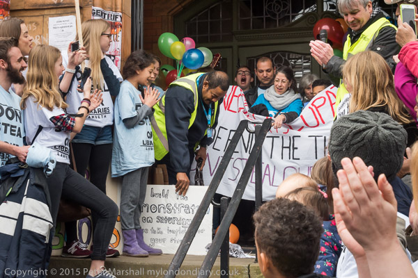
I was back at the library in 2016 at the end of a ten days of occupation by local residents against Lambeth council’s plans to turn it into a fee-charging gym run by Greenwich Leisure Ltd with an just un-staffed lounge with books. Their occupation had hit national headlines with huge support from around the country.

The gym plans went ahead, but with a little more library provision than originally planned and there is also now the Carnegie Library Hub based in the building, “a thriving sustainable centre of local activity attractive to the whole community for developing employment opportunities, learning, fitness and wellbeing, cultural and social activity” which protects and celebrates its history and legacy.

I didn’t take many more pictures as I walked back to Herne Hill and walked back down it. After a short walk along Half Moon Lane I turned around and went towards the station, where the next part of this walk will begin.


Ruskin & Half Moon, Herne Hill

Ruskin & Half Moon, Herne Hill is another in the series of posts on my walk in Kennington and Brixton on Sunday 6th May 1989. The walk began with Hanover, Belgrave, Chapel, Shops, Taxis. The previous post was A Couple, Shops, Shakespeare and a Green Man.

Parish Hall, St Saviour's Church, Ruskin Park, Herne Hill, Lambeth 1989 89-5e-51
Parish Hall, St Saviour’s Church, Ruskin Park, Herne Hill, Lambeth 1989 89-5e-51

I walked back towards Loughborough Junction station and then turned right down Herne Hill Road, but nothing caught my attention until I came to St Saviour’s Parish Hall on the corner of Finsen Rd. This was erected next door to the church in 1914 and is Grade II listed, its architect Beresford Pite. The hall is now in use as St Saviour’s Church.

St Saviour’s Church was an impressive Victorian building designed by A.D. Gough and consecrated in 1867. It was a short distance to the north on Herne Hill Road in what are now the grounds of St Saviours Church of England Primary School. It was made redundant in 1980 and demolished in 1982 as it was in danger of falling down.

Ruskin Park, named after the named after the noted Victorian writer and naturalist John Ruskin who grew up in the area is just on the other side of Finsen Road, and although I took no photographs here I think I may have found a seat in it to eat my sandwiches before continuing.

Houses, Milkwood Rd, Herne Hill, Lambeth, 1989 89-5e-42
Houses, Milkwood Road, Herne Hill, Lambeth, 1989 89-5e-42

I walked back up Herne Hill Road, taking a picture of one of the houses with distinctive porches in the terrace on the west side at 17-35 (not online) and then walking down Wingmore Road to the junction with Hinton Road and Milkwood Road and turning south to go along Milkwood Road towards the centre of Herne Hill.

Milkwood Manor covered a large area including Denmark Hill. The development around Herne Hill began in earnest after the railway station was opened in 1862, and more importantly later in the decade when services began to the City and Kings Cross. In 1868 the Suburban Village and General Dwellings Company took out a 99-year lease to develop twenty-four acres with houses that working men could afford, and cheap worken’s tickets made living in the suburbs possible. Most of those houses are now beyond the means of most working men.

Gubyon Avenue, Fawnbrake Avenue, Kestrel Avenue were all first developed at around the same time, I think largely from the 1880s with development continuing until a little after the end of the century. Much of the land was owned by a family called Gubbins, who perhaps thought Gubyon a more distinctive version of their name. 13 Gubyon Avenue is thought by the Sherlock Holmes Society to have been the location of Major Sholto’s residence, visited by Holmes and Watson accompanying Miss Mary Morstan in The Sign of Four, written in 1889.

The houses in my picture are probably older, in a similar but slightly less grand style and are closer to the centre of Herne Hill at 352 to 373 Milkwood Road. It’s perhaps surprising they lie just outside the Herne Hill Conservation Area.

Wandles, Car Sales, Flats, Milkwood Rd, Herne Hill, Lambeth, 1989 89-5e-4489-5e-44

Just a few yards from the end of Milkwood Road, these flats which have a frontage on Herne Hill are now hard to see from Milkwood Road, hidden by a two-storey block of Sainsbury’s Local and other buildings where the car sales once were.

What I have called flats its actually the rear of the 1906 LCC Fire Station at 130 Herne Hill, its rear with this rather odd gabled tower considerably more interesting than its rather plain Queen Anne frontage.

Half Moon, pub, Half Moon Lane, Herne Hill, Southwark, 1989 89-5e-45
Half Moon, pub, Half Moon Lane, Herne Hill, Lambeth, 1989 89-5e-45

Herne Hill is split in two by the boundary between the London boroughs of Southwark and Lambeth which runs along the centre of Herne Hill and Norwood Road – all the buildings in this picture are in Southwark borough.

There had been a pub here since 1760, although the current grade II* listed building dates from 1896. It was once one of London’s more famous music venues in London for around 50 years hosting among others U2, Van Morrison, Van Morrison, Dr. Feelgood and David Bowie. Even Frank Sinatra gave an impromptu performance here when he came to visit his former chauffeur on his first night as landlord in 1970.

Closed for around 4 years in 2013 after flooding from a burst water main it has been restored and reopened but no longer features live music. The Dulwich Estate which owns it had wanted to convert the pub to flats, but was prevented when it was listed as an Asset of Community Value by the council and the pub was bought by Fullers.

Shops, Half Moon, pub, Herne Hill, Half Moon Lane, Herne Hill, Lambeth, 1989 89-5e-46

Another view of the Half Moon pub, this time from a few yards up Herne Hill, with shops along the east side of that road. The Half Moon is one of a number of pubs which Dylan Thomas frequented on his visits to London, coming to watch London Welsh play Rugby at the nearby Velodrome. No alcohol was available there and after games the members retired to the Half Moon.

He is said to have found the name for his radio drama Under Milk Wood standing in in the doorway of the Half Moon looking across to Milkwood Road. I can find no evidence for the claims on web sites that he once lived in the road, but I don’t have a detailed biography.

Herne Hill Mansions, Flats, Herne Hill, Herne Hill, Lambeth, 1989 89-5e-32

I continued walking up Herne Hill (confusingly the name of a road as well as the area) and immediately past the Mobil garage – now replaced by Tesco Express – came to this large block of flats.

Houses, Herne Hill, Gubyon Ave, Herne Hill, Lambeth, 1989 89-5e-33

Continuing uphill up Herne Hill were an number of large late Victorian or Edwardian detached houses. This one on the corner of Gubyon Avenue was perhaps just a little larger and certainly had two sides clearly visible. As you can see there are other large houses further up the hill.

My walk will continue in later posts.


Flats, School, College, Houses, Temple, Shop

Flats, School, College, Houses, Temple, Shop: The final post on my walk on Sunday 9th April 1989. The previous post was Cold Harbour & Myatt’s Fields.

Houses, Cormont Rd, Myatts Fields, Camberwell, Lambeth, 1989 89-4j-44
Flats, Cormont Rd, Myatts Fields, Camberwell, Lambeth, 1989 89-4j-44

From Longfield Hall I wandered up Knatchbull Road to Cormont Road, which runs halfway around Myatt’s Fields Park on its southwest and northwest sides. I took half a dozen pictures which I haven’t digitised before coming to this on the corner of Brief Street which I think was built as flats. Almost all the buildings in the area are fine examples of late Victorian housing, largely in the Queen Anne style but there is perhaps a slightly overpowering amount of red brick directly onto the streets.

Houses, Brief St, Myatts Fields, Camberwell, Lambeth, 1989 89-4j-45
Flats, Brief St, Myatts Fields, Camberwell, Lambeth, 1989 89-4j-45

Another finely designed large block of flats a few yards down Brief Street, Burton House, its hedges a few years ago more tidily trimmed but now again reverting to wild. On the opposite side of the street is a short terrace of two storey houses with brief front gardens and Brief Street is appropriately short – a little under a hundred yards in length.

School, Cormont Rd, Myatts Fields, Camberwell, Lambeth, 1989 89-4j-34

According to Lambeth’s 2018 Character Appraisal for the Minet Conservation Area, “Kennington Boys’ High School (latterly known as Charles Edward Brooke School), Cormont Road opened in 1897.” This was a LCC board school and the Grade II listing states that this building dates from 1912, architect T J Bailey. It is listed on Historic England’s Heritage At Risk Register.

Confusingly – and I hope I have got this right – the school renamed itself Saint Gabriel’s College when it became co-educational as a Specialist Arts and Music College in 2012, and then moved out to Langton Road a few years later.

Myatts House, Cormont Rd, Myatts Fields, Camberwell, Lambeth, 1989 89-4j-35

Again from the Lambeth appraisal, “The former St. Gabriel’s College on Cormont Road opened in 1899 as a training college for Anglican schoolmistresses, the vision of Charles Edward Brooke, a senior curate of nearby St. John the Divine church; the attached chapel was added in 1903.” The style is described as “vaguely Art Nouveau“. In 1989 it was Myatts House, run by the ATC Group of Training Companies and offering courses in Accountancy, Finance, Management and I think Computers, though the final word on the sign is hard to read. Grade II listed.

The building was requisitioned in the First World War, becoming part of the 1st London General Hospital, and was where Vera Brittain was first stationed. Later it became a LCC rest Home. It is now residential, converted to expensive flats as St Gabriel’s Manor.

Calais Gate, Mansions, Cormont Rd, Myatts Fields, Camberwell, Lambeth, 1989 89-4j-36
Flats, Cormont Rd, Myatts Fields, Camberwell, Lambeth, 1989 89-4j-36

This is Calais Gate, also Grade II listed and said in the listing to date from the early 20th Century, though the Myatt’s Park history site dates that these large mansion blocks as c. 1895.

Perched on top of the fine stepped gable is a terracotta cat, one of a number of cats on buildings on the Minet estate, though most are rather less prominent. The whole estate was developed by the Minet family who were of French Huguenot origin, and their name is an affectionate or childish French term for a cat, (minette if the cat happens to be female.)

Houses, Calais St, Myatts Fields, Camberwell, Lambeth, 1989 89-4j-22

Substantial houses in Calais St facing the park on the north-east side. I wondered when I took this on the significance of the gateway at left with the cross above, but am no wiser now. Hard to make out from this picture but those are cats heads above the doorway.

Houses, Flodden Rd, Myatts Fields, Camberwell, Lambeth, 1989 89-4j-24

Fine railings and decorative elements on these houses at 22 and 24 Flodden Road make them stand out and the absence of cats perhaps suggests these large semidetached Queen Anne style houses were not a part of the Minet development. Instead there are leaves and floral motifs and human heads.

Flodden was the site of a battle in 1513 in Northumberland, close to the border with Scotland when the English Army soundly defeated the army of King James IV of Scotland. England were engaged in a war with France and the Scottish invasion was in support of the ‘Auld Alliance’ they had made with France in 1295.

Calvary Temple, Councillor St, Camberwell, Lambeth, 1989 89-4j-11

It was time for me to leave the area, and I walked up Flodden Road to Camberwell New Road to get a bus, coming out almost immediately opposite Calvary Temple of the United Pentecostal Church a few yards to the north of the road in Councillor St.

The church incorporates a memorial stone “laid by William Appleton Esq (Sutton), June 2nd !890″ with the text “Hitherto Hath the Lord Helped Us” (1 Samuel 7:12), naming George Baines Architect and H L Holloway Builder. The church, then Clarendon Chapel, opened as a Baptist church in March 1891, replacing an earlier ‘tin tabernacle’ which had burnt down in 1889. Clarendon Street became Councillor Street some time before 1912 and the church was renamed Camberwell New Road Church, continuing in use for Baptist worship until the 1950s.

It narrowly escaped demolition in 1959 when it was saved by Caribbean immigrants who were looking for a building for their Pentecostal worship and they held their first service there in March 1959. They kept and restored the churches original late Victorian fittings and it remains in use.

Then and now it makes a dramatic composition with the tower block behind, Laird House on Redcar St, one of five 22-storey 210ft blocks on the 1966 LCC Wyndham & Comber Estates.

New Road Bargains, Camberwell New Road, Lambeth, 1989 89-4j-12

There are few if any shops in Myatt’s Fields but several parades within walking distance including on Camberwell New Road where at 243 was New Road Bargains with a small chair fixed above its door and a wonderfully packed window of assorted items. For some years this has been Camberwell Daily, now with a shop front that offers GROCERIES | FRUIT & VEG | OFF LICENCE | NEWS & MAGS.

I might have photographed other shops in the row, but my bus came and I got on it to begin my journey home.

This was the end of my walk on on Sunday 9th April 1989. The posts on it begin at Peckham and East Dulwich 1989.


Cold Harbour & Myatt’s Fields

My walk on Sunday 9th April 1989 continues in this post, Cold Harbour & Myatt’s Fields. The previous post was Camberwell & Myatt’s Fields.

Church, Shop, Coldharbour Lane, Camberwell, Lambeth, 1989 89-4j-61

Back in 1989 I was still pretty pressed for cash, still buying film in bulk 100 ft lengths and loading it into cassettes myself in total darkness.

Over the years I’d perfected my method. Two nails on the back of my darkroom door, hang one of the sprocket holes at the end of the roll of film on the top one, unroll it down to the second, cut across, replace film in can. Pick up first spool from a waiting row on the bench, already with a short length of masking tape on it, attach to the bottom end of the hanging length of film, carefully roll it up to the top, remove from nail, pick up cassette body, insert spool with film end though velvet light trap, pick up end cap and pinch cassette to push it into place. Repeat another 18 times until the film roll is finished. Turn on light, trim film ends to fit cameras and put into plastic pots to go into camera bag.

Slow, tedious but then less than half the cost of buying film in 26 exposure cassettes, though I did ocasoinally treat myself – and if I bought Ilford film rather than Kodak I could reuse the cassettes with bulk film. Kodak had crimped on ends which had to be removed with a bottle cap remover destroying them.

I had learnt to be very careful with film in this project to photograph London, working with 35mm cameras much as I would have done with large format camera, carefully considering various viewpoints before deciding on an exposure. But when working with people I had to respond rather more quickly, and seeing these two men in front of the white church door my response was immediate.

Shops, Coldharbour Lane, Camberwell, Lambeth, 1989 89-4j-62

After that rather snatched image I continued with photographing the two shops which had attracted my interest here, making first a vertical image and then moving back across the road for a wider view. In this (below) you can see the notice for the Celestial Church of Christ and the alley leading to this.

Shops, Coldharbour Lane, Camberwell, Lambeth, 1989 89-4j-63

As well as these black and white images I also took a couple in colour which you can see in another album. I had two Olympus OM bodies with me and only brought the one with colour negative film out of my bag occasionally, while the black and white camera was usually on a strap around my neck. When I was intending to photograph people rather than buildings I usually went out with a Leica M2 instead.

Coldharbour Lane leads from Camberwell to Brixton and got a very bad reputation after the 1981 clashes between police and locals in Brixton. In 2003 it was called in an article in the London Evening Standard the most dangerous street in the most dangerous borough in London, but that was lagely rabid tabloid journalism. Wikipedia gives several theories about its name none of which seem entirely convincing, but the name seems often to have been associated with the ruins of Roman or Romano-British settlements, The area we know usually call Loughborough Junction around the station on early maps was called Cold Harbour. Coldharbour Lane was then known as Camberwell Lane.

Cafe,  Hinton Rd, Camberwell, Lambeth, 1989 89-4j-65
Café, Hinton Rd, Camberwell, Lambeth, 1989 89-4j-65

The S&J Corner Café was on the corner with Wellfit Street, close to Loughborough Junction station. The railway line here is just south of the station. A second bridge can be seen going above this and the cafe which is the line from Brixton to Denmark Hill, now used by London Overground services.

Cyclist, HInton Rd, Camberwell, Lambeth, 1989 89-4j-51
Cyclist, Hinton Rd, Camberwell, Lambeth, 1989 89-4j-51

Another picture I took on the spur of the moment as I saw a cyclist coming towards me under the bridges on Hinton Road. I was standing on the pavement beside the cafe in the previous image, and the cyclist is on the pavement, rather safer than roads like this in London. At the end of the row of shops on the left are the traffic lights and Coldharbour Lane whch I had just begun to walk towards.

Hinton Rd, Camberwell, Lambeth, 1989 89-4j-52

The pub at right of this picture is The Green Man on the corner with Coldharbour Lane. According to a post on the Brixton Buzz, this had been on the site since 1881, but that is the date of the current building which replaced an earlier pub on the site important enough to be marked on Stanford’s 1862 map. The Buzz says it was closed in 2003 because of drug dealing and crime, and it quotes from the Urban75 blog that it was “was frequented by dealers (crack, heroin you name it), prosi’s and general madhatters.

The buildings at the left date from around the same time as the area was developed around the railways, and number 6 at left has a barely legible road name ‘Hinton Terrace‘ and I think at the top the illegible name of a builder and decorator whose sign presumably once hung on the bracket beside the street name.

House, Lilford Rd, Camberwell, Lambeth, 1989 89-4j-53
Houses, Lilford Rd, Camberwell, Lambeth, 1989 89-4j-53

I walked up past Loughborough Junction and made my next picture on Lilford Road at the corner of Minet Road, returning to the area I had been earlier on this walk, the Minet Estate around Myatt’s Fields. This is on the corner of a terrace with basement flats with an entrance here under the steps which extends along both streets and this grand entrance is actually for two adjoining houses above the flats, one on each street. The Grade II listing calls these “Early-mid C19″ and describes this a “double prostyle composite porch with fluted composite columns.”

Longfield Hall, Knatchbull Rd, Myatts Fields, Camberwell, Lambeth, 1989 89-4j-54
Longfield Hall, Knatchbull Rd, Camberwell, Lambeth, 1989

William Minet founded this Grade II listed community hall, architect George Hubbard, which opened in 1889, as well as the Minet library opposite which was destroyed by bombing and rebuilt in 1956 in what Pevsner described as ‘a meek replacement’. The Library was a memorial for his late wife. The Hall is still in use for various community activities including three church congregations and from 1969 -1975 was the base of Britain’s first Black Theatre Company, ‘Dark And Light’, recently marked by a Blue Plaque. It was Grade II listed in 1979 and is now run by a charity, The Longfield Hall Trust.

My walk made on on Sunday 9th April 1989 will finish in a later post. The first part from it is at Peckham and East Dulwich 1989.


Peckham and East Dulwich 1989

Courtyard, Peckham Rye Station, Rye Lane, Peckham, Southwark, 1989 89-4h-35

The day after my walk around King’s Cross, in part on a walk led by GLIAS, on Sunday 9th April 1989 I was back in London on my own, south of the river for a walk beginning in Peckham.

People have often asked my why I photographed the areas of South London, and although I tell them I also photographed the North, East and West, my interest was certainly was certainly inspired by a remarkable book, London South Of the River, by Sam Price Myers, published in 1949, illutstrated by some fine wood engravings by Rachel Reckitt.

Back in 1989 there was relatively little graffiti in the area, but much of the walls in the 1930’s building at the centre of the picture where an arcade leads left towards Rye Lane was covered fairly colourfully last time I visited. You can just see a little of the station at right through the first arch. The second arch on Station Way leads to Blenheim Grove,

Courtyard, Peckham Rye Station, Rye Lane, Peckham, Southwark, 1989 89-4h-36

Myers does not have a great deal to say about Peckham, but has an engaging enthusiasm for the subject matter. His short section on the area does, like me start at Peckham Rye Station, though I had probably not arrived by train but on a bus to Peckham from Vauxhall. The book also contains some decent photographs, though greatly weakened by the rather pallid reproduction of the era, by a number of photographers including Ursula Hartleben and Bernard Alfieri.

My copy, bearing the stamp of the Illustrated London News Editorial Library, was certainly £4 well spent, and I find a copy in rather better condition now offered for sale on the web for £555; the advert shows several of Reckitt’s illustrations, and another was posted by a friend on Twitter. You can still find copies of the book in similar condition to mine for a rather more reasonable price.

This picture is looking north up Station Way from outside the station entrance towards Holly Grove. My interest on this occasion was obviously rather more in the 1930s building than the Victorian station,

Shop, Blenheim Grove, Peckham, Southwark, 1989 89-4h-21

This was another part of the 1930s development in front of the station between it and Rye Lane, here with shops and flats above. I walked the few yards east into Rye Lane and continued south down this, taking few pictures as I had photographed this area on previous walks.

Matrix Gym, Rye Lane, Peckham, Southwark, 1989 89-4h-23

Continuing south, Rye Lane merges into Peckham Rye, and I often confused the two. The numbers on the door frame here are 257-261 and this was a part of the former Co-Op building at the bottom of Rye Lane, now demolished and replaced.

Lock, Peckham Rye, Peckham, Southwark, 1989 89-4h-12

The giant lock with its legend YALE LOCKS was became labelled the entrance to Ezel Court (which I think was just the flats above the shops), but I assume that at one time either 56 – here dealing with pets – or the shop to the left had sold locks. In recent years these have become a Mini Super Market and a restaurant. I had photographed this earlier in the year and another picture appears in my post Peckham Rye to Goose Green – 1989.

Houses, Kelmore Grove, East Dulwich, Southwark, 1989 89-4h-13

I continued down Peckham Rye to the junction where I turned to the west along East Dulwich Road. In 1879 this there were really substantial villas along the south of East Dulwich Rd, but by the early 90s Oakhurst Grove, Kelmore Grove and The Gardens at the back of these had been laid and lined with substantial family homes.

These beautifully decorated late Victorian houses are on the south side of Kelmore Grove, with slightly plainer examples on the other side of the road. Although only two storey, these are substantial semi-detached houses with a wide frontage with a large room on each side of the central hallway.

Houses, Oakhurst Grove, East Dulwich, Southwark, 1989 89-4h-14

The houses in Oakhurst Grove have alternate bays and rather curious towers in what are semi-detached three storey houses. The two doors in each pair are adjacent with only a room on one side and although taller they are less grand than those in the picture above. But they also have some fine brickwork and decorative elements.

This walk will continue in later posts.


St Omer & Arques 1993

Mostly I’ve photographed London over the past 50 or so years, with just a few earlier pictures that I think I have lost, including the first film I ever had processed, of ancient oak trees in Richmond Park back in 1962. It cost me 17s 6d to get it processed and it was years before I could afford to do more. I think all of the pictures are now lost. But I have also photographed elsewhere, particularly in Hull and Paris, and also on a number of holidays, some where I’ve perhaps taken photography more seriously than others. But I’ve always had a camera with me.

Cyclists, France

A few of those holidays have been cycling holidays, including a ride up the Loire valley and a couple of others in northern France. France is a better place to cycle than the UK for various reasons. It still has mile after mile of largely empty rural roads and French drivers have a much more positive attitude towards cyclists. More of them are cyclists themselves or have been.

le Marais Audomarois, St Omer, France

One such holiday was in late August 1993, when I went with my wife and two sons, aged 14 and 17 to northern France. Our rides were fairly leisurely with not the slightest whiff of Lycra and frequent stops for me to repair the punctures of the others or carry out other running repairs. My own bike, a 1956 Cinelli bought secondhand for me by my eldest borther for my 13th birthday performed without any such problems. I’ve recently scanned and put the pictures from our holiday into a Flickr album.

Water Tower, near Cassel, France

Two things made that difficult. One was the poor trade processing of the colour negative film I used, with one film having two large gouges across most frames along with some other damage which required extensive digital retouching. I tried out Photshops new AI filter which removed them perfectly – but also took out some other parts of the image, so I went back to doing the job manually.

Tower, Hauts-de-France, France, 1993, 93c08-01-71

But what took as much or rather more time was trying to identify the locations for many of the images. I’ve done my best, but some are still rather vague and others may be wrong. I’m hoping that some viewers on Flickr will help and tell me more. If you know the area around Calais, Ardres, St Omer, Arques and Cassel please do take a look. The pictures are rather mixed up in order, and I was using two cameras, both with colour negative film, for reasons I can not now understand.

Canal, Rue des Faiseurs de Bateaux, Saint-Omer, Hauts-de-France, France, 1993, 93c08-01-41

On 23 August 1993 we made an early morning start on a train to Clapham Junction and rode from there to Victoria. The train to Dover and the crossing to Calais for the four of us cost £42 for a fivee-day return ticket and our bikes travelled free. We arrived in mid-afternoon and an easy ride took us to the hotel we had booked in Ardres.

Bridge, Canal, Hauts-de-France, France, 1993, 93c08-01-43

The following day was a more difficult ride, and we had a nasty few minutes when Joseph’s chain came off and jammed between sprockets and hub far from any town or village, close to the high speed line then being built for Eurostar, work on which had involved us in a number of detours, and for years I’d look out of the window a few minutes after we came out of the tunnel and recognise the short uphill stretch were it happened.

Blockhaus d'Éperlecques, Éperlecques, France

Eventually after much sweating I managed to free it and we could proceed. For some reason we had decided to visit the Blockhaus d’Eperlecques, built in 1943 as a base to launch V2 rockets at Britain, but destroyed by bombing and now a French National Monument with some very large holes in its concrete roof.

Bridge, near St Omer, France

Our route to it involved a rather large hill but we were able to rest a bit and look around the site before continuing on our journey to St Omer. Here we found another slight problem with our French map, which showed what looked like a nice quiet route on to Arques. It turned out to be an abandoned railway track, complete with sleepers and impossible to ride. After struggling for a while we turned back and took the N42 instead and soon reached Arques.

L'Ascenseur à Bateaux des Fontinettes, Arques, France

At Arques we were just in time for the last guided tour of the day of the 1888 boat lift, L’Ascenseur à Bateaux des Fontinettes, modelled on the Anderton lift in Cheshire, replacing 5 locks and taking 22 minutes to transfer boats up and down by 13.13 metres – 43 ft. It was closed in 1967 as traffic had grown considerably and replaced by a single modern lock.

A la Grande Ste Catherine, Hotel, Hauts-de-France, France, 1993, 93c08-01-52

At Arques we had booked a three night stay at ‘A la Grande Ste-Catherine’ . Including breakfasts for us all and a couple of dinners for the two of us (our two sons wouldn’t eat proper French food) this cost 1832 Francs, then a little over £200. They ate frites and burgers from a street stall, though one night we did all manage to find food for all of us at a supermarket restaurant.

le Marais Audomarois,, St Omer, France

The next day we returned to look around St Omer, and then rode to Tilques, abandoning saddles for a boat trip around le Marais Audomarois, one of the more interesting parts of our visit.

Rooftops, Cassel, France

And for our last full day in France we took a ride to Cassel, a town on a hill that rises to the highest point on the Plain of Flanders, surrounded by flat lands in all directions, taking an indirect route via the Forêt Domaniale de Rihoult (Clairmarais), rather disappointing as it was full of noisy schoolkids from their colonies de vacances.

Radio Uylenspiegel, Cassel, France

It was a struggle up the hill to Cassel, and we were glad to rest for a while at the cafe inside the grim fortress of a Flemish language radio station – former a casino and I think the local Gestapo headquarters. Our ride back to Arques was by the direct route and began with a long downhill stretch where no pedalling was needed for a very long way.

A Cathelain,  Bavinchove, France

Finally came our last day, and I planned an easy route back to Calais, mainly beside canals. But the others objected and demanded a visit to the Eurotunnel exhibition on the way, which held us up considerably, not least because most of the roads had been diverted to build the high speed line and our map was fairly useless. We finally managed to catch the 19.15 ferry, a few hours before our ticket expired.

Many more pictures in the Flickr album Northern France – St Omer.


Highgate April 1989

Friday 7th April 1989 was at the end of my Easter break from teaching and I took the opportunity to take a walk in North London, taking the North London Line from Richmond to Gospel Oak.

Nautilus Fitness, Advertising, Sinclair C5, Highgate Rd, Dartmouth Park, Camden, 1989 89-4a-54
Nautilus Fitness, Advertising, Sinclair C5, Highgate Rd, Dartmouth Park, Camden, 1989

I walked up to Highgate Road where I found this unusual form of advertising, with a Sinclair C5 piggy-backing on a Datsun. On the back of the C5 were these two boards, one with a woman’s face at the top.

The C5 was doomed from the start and it’s hard to understand why any competent businessman had ever thought it could succeed. Recumbent bicycles have never attracted wide ownership despite their mechanical advantages; perhaps if there were no cars, lorries, buses etc on our road they might have done so. And the C5 was just a recumbent trike with an electric motor and some plastic bodywork.

It’s low viewpoint made driving in traffic unsafe, the bodywork gave little or no protection, the carrying capacity was one person and virtually no other load and its range – even if it could have made the promised 20 miles – too low. And with a top speed of only 15mph and little protection from the weather. Only 5000 were sold before the company failed, although the unsold stock later became a cult item for off-road use and often substantial modifications – with some re-engined and souped up to 150 mph.

Houses, Highgate Rd, Dartmouth Park, Camden, 1989 89-4a-55

These substantial houses just south of St Alban’s Road now have lost the dark finish which provided a contrast on the upper floors. The wide gateway under the ventre of the two linked blocks leads through to Oak Court, a post war block. perhaps from the 1960s presumably built by St Pancras Council in the gardens of these houses behind St Albans Villas with a vehicle entrance from St Albans Rd.

Houses, Highgate West Hill, Highgate, Camden, 1989 89-4a-41

Highgate Road ends at Swains Lane, but Highate West Hill continues in the same direction, and walking up it you notice the hill. The large semi-detached house in the foreground is No 23 and you can see that No 27 is a few feet higher up the hill. Some of the other houses in this row have similar tiled decorations to those on No 25 at the middle of the picture and I imagine all once did. Just a little further up is No 31 where John Betjaman grew up.

Wall, Highgate West Hill, Highgate, Camden, 1989 89-4a-45
Wall, Holly Terrace, Highgate West Hill, Highgate, Camden, 1989 89-4a-45

It’s quite a low walk uphill, and much of the road is lined with fences and trees which hide the houses behind, and I made few pictures. Nearing the top of the hill you can still see this wall with an unusual curve at 1 Holly Terrace and that rather crazy tree as well as the fine house is still there too. These houses date from around 1807, built on the site of an older property.

House, Highgate West Hill, Highgate, Camden, 1989 89-4a-33

The hill continues upwards, with this slightly odd villa at No 80, looking to me rather like a German toy house. Beyond it you can see South Grove House and the spire of St Michael’s Church in South Grove, the highest church in London, architect Lewis Vulliamy (1791-1871), consecrated in 1832 and one of the earliest neo-Gothic churches.

It was one of 600 new churches built following the 1818 passage of An Act for the Building and the Promotion of Building Additional Churches in Populous Parishes. It was actually completed nine months before it could be consecrated, having been completed in something of a record time of 11 months, but another Act of Parliament had to be passed to allow its consecration as “The land on which it was built was from the parish of St Pancras, which was a peculiar under the jurisdiction of the Dean and Chapter of St Paul’s Cathedral.”

Highgate Society, Highgate Literary, Scientific Institution, South Grove, Highgate, Camden, 1989 89-4a-21

In South Grove I made this picture of the Highgate Literary & Scientific Institution, which has the date 1839 above it. The building was earlier, having previously been a school, and the building got a new porch and frontage in the 1880s. Such institues were common during the 19th century before the establishment of public libraries, but few now remain still offereing “opportunities for life-long learning through its courses, library, archives, art gallery, lectures, debates, cultural and social events.

More on this walk in a later post.


High Rise, Houses, Car Parts, and a Club

Continuing my walk in Peckham in March 1989. The previous post on this walk was Asylum, Lorry Park, Works, Museum & Office Door.

Bird in Bush Rd, Peckham, Southwark, 1989 89-3c-21
Bird in Bush Road, Peckham, Southwark, 1989 89-3c-21

I spent some time exploring the area around Malt Street and Ossory Road, now on the other side of Asda, where some demolition was taking place but took few photographs, none on-line, and then walked back along along the Old Kent Road to Peckham Park Road, going down this to Green Hundred Road. I found myself in a large area of council housing, much of which was fairly standard LCC five storey blocks dating from the late 1930s, solidly built, their height limited back then by the lack of lifts.

The foreground flats in this picture are from the late 60s and are on Bird in Bush Road, part of the GLC designed Ledbury Estate, and as well as these 4-storey maisonette blocks there were also four identical 14 floor H shape tower blocks, including this one, Bromyard House, which has its entrance on Commercial Way.

Bird in Bush Road, Peckham, Southwark, 1989 89-3c-22

This picture was taken from close to the east end of Bird in Bush Road, and the building cut off at extreme left of the image is the former Arthur Street Board School (now Camelot Primary School.)

The design dates of these flats, also on the Ledbury estate, is from the early 1960s and was replicated across London by the GLC, using the prefabricated Danish Larsen-Nielsen system. After one at Ronan Point suffered a disastrous collapse following a gas explosion flats built using this system should have been strengthened, but somehow Southwark Council failed to do so on this estate. I’m not sure whether this had now been put right. but none have yet collapsed.

Doddington Cottages, Commercial Way, Peckham, Southwark, 1989 89-3c-24

This semi-detached residence dating from 1836 which was Grade II listed together with the neighbouring Doddington Place around nine years after I took this picture.

The name possibly comes from Doddington Hall in Cheshire, built by Samuel Wyatt for Sir Thomas Broughton in 1777-90 and its parkland landscaped by Capability Brown. There is also Doddington Place at Doddington near Sittingbourne in Kent, but this was only built around 1870.

Tustin Estate, Old Kent Rd, Peckham, Southwark, 1989 89-3c-11

The Tustin Estate is on the north side the Old Kent Road immediately west of Ilderton Road. It has three 20 storey towers, Windermere Point, Grasmere Point (in the centre here) and Ambleside Point, each with over 70 flats which were approved by the GLC in 1964. There are also six low-rise blocks on the estate.

According to Southwark Council, “In March 2021, residents voted in favour of demolishing and rebuilding the low-rise buildings in a residents’ ballot. This will include replacement council homes, additional council homes and key worker housing, shared equity homes and homes for private sale. There will also be a replacement school building, new commercial spaces and a new park. All existing residents will be able to move to a new council home in the first phase of the scheme.” I’m unsure how far this scheme has so far progressed and it remains to be seen whether the council will keep its promises, which it almost completely failed to do on some earlier schemes.

Clifton Crescent, Peckham, Southwark, 1989 89-3c-13

I returned to Clifton Crescent which I had photographed earlier and too a rather better and closer picture of this magnificent curved terrace. As I explained earlier, it was Southwark Council’s decision in 1972 to demolish this crescent that led to a local action group which became the Peckham Society in 1975. Fortunately they managed to stop the demolition when only No 1 had been lost. They convinced the council that retaining and restoring the properties was a cheaper option, and the lost house was rebuilt and the entire crescent, Grade II listed thanks to their efforts in 1974, was restored by 1977. The Crescent was built in 1847-51 and represents an interesting transition between earlier Regency styles and the simpler Victorian terraces.

Car spares, Loder St, Peckham, Southwark, 1989 89-3c-15

From there I made my way east, going under the railway on Culmore Road or Clifton Way and then south to Loder St. This whole area has been redeveloped since I made these pictures in 1989 and is now covered with low-rise housing. I made two pictures of this car breaker’s yard (you can see the other on Flickr).The tower blocks are those of the Tustin Estate.

Hatcham Liberal Club, Queen's Rd, New Cross, Lewisham, 1989 89-3d-61
Hatcham Liberal Club, Queen’s Rd, New Cross, Lewisham, 1989 89-3d-61

I walked down to Queen’s Road, I think along York Grove, stopping briefly to photograph a street corner. On Queen’s Road before catching a bus I photographed the Hatcham Liberal Club, built in 1880 in Queen Anne Dutch style and Grade II listed ten years after I took this picture. It was one of the largest of a number of late Victorian working men’s clubs and became a popular venue with a large hall at the back available for hire for parties and gigs and also for until it closed in 2006. In 2009 most of the interior was converted into flats.

Shops, John Ruskin St, Camberwell, Southwark, 1989 89-3d-62

I changed buses in Camberwell, where I made a slight detour to make another visit to photograph the row of shops on John Ruskin Street as the final picture of the day and this walk.

The first post about this walk was Shops, Removals, Housing and the Pioneer Health Centre. I’ll post about my next walk in 1989, in the City of London, shortly.


Costa, A Corner & Our Lady of Sorrows

Costa, A Corner & Our Lady of Sorrows continues my walks in Peckham in March 1989. The previous post was A Laundry, Crescent, Shops, Mission & Settlement.

G Costa & Co, Marlborough Works, Staffordshire St, Peckham, Southwark, 1989 89-3b-54

G Costa, importers and distributors of fine foods was founded in 1879 and incorporated in 1913. The company moved out of Peckham to another of its sites in Aylesford Kent in 1994, and was bought by Associated British Foods in 2003.

Among its products is the Blue Dragon range of sauces and ingredients for Chinese, Japanese and S E Asian meals. The factory site has since been developed as housing.

Staffordshire St area, Peckham, Southwark, 1989 89-3b-55
Staffordshire St, Peckham, Southwark, 1989 89-3b-55

Although this building has been replaced by a new block, these is still a slight bend here at the south end of Staffordshire Street just before it ends on Peckham High St. There are still some posts along the side of the pavement, but no longer needed to protect pedestrians from lorries from the factory, but three hoops to lock a bike to outside the entrance to Gaumont House.

This block was the site of the first Gaumont Palace Theatre to be built in London in 1932, on the site of the 1898 Peckham Hippodrome Theatre on Peckham High St between Marmont Road and Staffordshire Street. Later it became simply The Gaumont and was damaged by bombing in 1941 and a V1 flying bomb in 1944, managing to re-open after both a few months later. Refurbished in 1948 it closed in 1961 and was converted into a Top Rank Bingo club with boxing matches once a week. It was sadly modernised in the 1970s, closed in 1998 and was demolished in 2002.

I was attracted by the odd pattern of rectangles, including one one the pavement in the foreground and others along the wall, with those each side of the leaning lamp post formed by shadows rather than the actual doorways and subtly subverting the impression of space in the picture.

Marmont Rd, Peckham High St, Peckham, Southwark, 1989 89-3b-56

I took two pictures on this street corner, the first on an impulse when a man walked in front of me as I was getting ready to take a picture, his shadow falling on the tiles of the doorway.

Marmont Rd, Peckham High St, Peckham, Southwark, 1989 89-3b-41

But this is the picture I had stopped to take, and rather more carefully composed. If you look carefully from this corner now you can see that the five windows in my picture have all been bricked up, with just a small window left at the top of the lowest one. The block of flats further down Marmont Road is still there though now rather hidden by trees.

At right the curve with lights is above the tiled entrance to the foyer of the Top Rank Bingo Club, built in1932 as the Gaumont Palace Theatre, though later modernised. The large foyer extended out into the street corner in a single storey curve from the massive brick block of the cinema.

There is still a curved corner at the right, but to a newer and rather anonymous building on the site, Gaumont House.

Houses, Friary Rd, Peckham, Southwark, 1989 89-3b-42

This terrace of splendid double-fronted Victorian houses, continued at the left by some slightly less grand without a first floor window over the central door is still there on Friary Road.

The road was developed in the 1840s as Lower Park Road, when Peckham Park, also known as Peckham New Town was a very desirable middle class suburb. Like many other London roads it was renamed in the 1930s and became Friary Road, named for the Friary on the corner of this road and Bird in Bush Road.

Our Lady of Sorrows, Catholic, Church, Bird in Bush Rd, Peckham, Southwark, 1989 89-3b-43

For some reason the church here is listed as the Church of Our Lady of Seven Dolours on the Old Kent Road, Southwark, London, SE15, a quarter of a mile away, although the listing does include the correct address of Bird in Bush Road where my picture was taken showing the side of the Grade II listed church.

This very large church was designed by the prominent Victorian church architect E W Pugin and built from 1859 to 1866, delayed by lack of funds, for the Capuchin Friars. They built a Friary next door (designed by James O’Byrne) on what is now Friary Road in the 1884s and served the church there until 2000 when the Friary buildings were handed to the archdiocese and are now home to a Vincentian community.

Our Lady of Sorrows, Catholic, Church, Mission House, Friary Rd, Peckham, Southwark, 1989 89-3b-44
Peckham Friary, Catholic, Church, Mission House, Friary Rd, Peckham, Southwark, 1989 89-3b-44

These are the 1884 buildings for the Capuchin Friars from where they served the church and community until 2000.

More on this walk in March 1989 to follow. The first post about this walk was Shops, Removals, Housing and the Pioneer Health Centre.


Aged Pilgrims, Sceaux, Houses & Lettsom

I began another walk from Camberwell on Sunday 12th February 1989, starting from a bus stop on Camberwell Road I made my way east towards Sedgemoor Place.

Almshouses, Aged Pilgrims' Friendly Society's Home, Sedgemoor Place, Camberwell, Southwark, 1989 89-2c-23
Almshouses, Aged Pilgrims’ Friendly Society’s Home, Sedgemoor Place, Camberwell, Southwark, 1989 89-2c-23

The Aged Pilgrims’ Friend Society was established in 1807 by a group of Christians concerned about “the aged and infirm Christian poor”. William Wilberforce, best known as an anti-slavery campaigner, was its Vice-President in the early years. At first it provided life pensions to Protestants over 60 whose income was less than 5s (25p) a year and by 1825 had supported over 800 pensioners with pensions of five or ten guineas a year.

The Aged Pilgrims’ Friend Society were given a site in Camberwell by William Peacock Esq and raised the money to build their first almshouses there, opening in 1837 to house 42 pensioners. The Tudor-style building is Grade II listed. It was sold by the Aged Pilgrims’ Friendly Society who by then had added an ‘ly’ to there name in 1991 and is now flats.

Almshouses, Aged Pilgrims' Friendly Society's Home, Sedgemoor Place, Camberwell, Southwark, 1989 89-2c-24
Almshouses, Aged Pilgrims’ Friendly Society’s Home, Sedgemoor Place, Camberwell, Southwark, 1989 89-2c-24

The Aged Pilgrims’ Friend Society were given a site in Camberwell by William Peacock Esq whose donation is recorded above the doorway and raised the money to build their first almshouses there, opening in 1837 to house 42 pensioners. The Tudor-style building is Grade II listed. It was sold by the Aged Pilgrims’ Friendly Society in 1991 and is now flats.

St Giles' Hospital, Havil Street, Camberwell, Southwark, 1989 89-2c-26
St Giles’ Hospital, Havil Street, Camberwell, Southwark, 1989 89-2c-26

The picture shows the demolition of former workhouse and the start of the conversion to flats of the Grade II listed circular ward tower fronting onto Havil Street. This was built in 1889-90 for the Camberwell Workhouse Infirmary, later St Giles’s Hospital, architect W S Cross. Each fllor contained 24 beds radiating around a central shaft, in which heating and ventilation services were located. I had photographed this building on a walk a few weeks earlier and had gone back to see if work was progressing and I could get a better view.

Statue, sculpture, Sceaux Gardens Estate, Peckham Rd, Camberwell, Southwark, 1989 89-2c-12

Plans for the Sceaux Gardens estate in the mature grounds of the former Camberwell House Lunatic Asylum were approved in 1957 and included two 15 storey tower blocks, Lakanal House and Marie Curie House. The estate was named after Sceaux near Paris which Camberwell had twinned with in 1954. I’ve visited Sceaux a few times and it has a rather better palace and park where festivals are held.

The Lakanal fire in 2009 killed 6 and injured at least 20 more; the recommendations from the enquiry were not implemented but would have prevented the later even more disastrous fire at Grenfell Tower. I think this block is probably Lakanal, but can find no details about the statue – and it certainly isn’t Lakanal.

Joseph Lakanal (1762 – 1845) was a French politician, and an original member of the Institut de France and one of the leading administrators of the French Revolution and responsible for educational reforms. He spent some time in the USA and helped to found and became President of what later became Tulane University before returning to France.

Camberwell Church St, Camberwell, Southwark, 1989 89-2d-63

I walked back west along Peckham Road to Camberwell Church St, pausing to take a couple of pictures not online and then this view of houses and a shop on the south side of the street, possibly at 70-72.

Houses, Camberwell Grove, Camberwell, Southwark, 1989 89-2d-65

I was on my way to Camberwell Grove to make photographs in the northern part of the street which I had not visited on my earlier walks. Just a few yards down the street I turned around and took this view looking up towards Camberwell Church St. At left is the path to Chamberlain Cottages mentioned in an earlier walk.

Houses, Camberwell Grove, Camberwell, Southwark, 1989 89-2d-66

A little further down I found this terrace with two porches on houses in the centre. Like most of the buildings along this part of the street this is Grade II listed, described as ‘Early C19 with some later C19 alterations’.

Flats, McNeil Rd, Camberwell Grove, Camberwell, Southwark, 1989 89-2d-52

The flats at left are 125-151 Camberwell Grove and you can see the spire of St Giles Camberwell in the distance. This is the Lettsom Estate, named after John Coakley Lettsom (1744-1815) who lived in Grove House, just beyond the southern end of Camberwell Groce, long demolished. He was Quaker physician and herbalist, who was friends with Benjamin Franklin, Dr. Johnson, Boswell and other leading figures of the day. This land had been a part of Lettsom’s estate.

When the flats were built in the early 1970s their scale was designed to match the nineteenth century housing along this section of Camberwell Grove – although they have four floors rather than the three in most of this. Their brickwork is also of a similar colour but they lack any of the interesting features of the older buildings and are relatively bland.

I made my way through the estate and on to Vestry Gardens where my next post on this walk will begin.