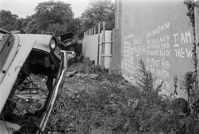
1986 was the year I began seriously to photograph the fabric of London, and the number of photographs on Flickr, 1,370 reflects this, although I took several times this number, mainly in a series of planned walks exploring different areas of the capital.
Caledonian Rd, Kings Cross, Islington
A few of those I’ve not digitised are near duplicates, though usually I only took a single image of each subject, often taking some time to consider the best viewpoint and sometimes waiting for people or traffic to leave me a clearer view. Although I was working on 35mm and almost always hand-held, my approach was generally like that of a photographer using a larger camera – and the 35mm Olympus shift lens gave me much of the flexibility of large-format camera movements.
Nat West Tower, Old Broad St, City
I had tried using 4×5″ cameras, a first with a monorail and then with an MPP, but found them too restrictive. Heavy to carry any distance, slow to set up and even with several magazines and a small pile of dark slides I was very limited in how many exposures I could make in a session. The movements on the MPP were also fairly limited, and the Olympus shift lens was more useful for this. While I admired the quality of large format results – and tried at times to emulate it by using Kodak Technical Pan – it wasn’t practical (or affordable) for the kind of large-scale project I had embarked on.
Venus, Canonbury Rd, Islington
Most of these walks in October 1986 were in Islington, where I walked around areas including Clerkenwell, Pentonville, Canonbury, Barnsbury, Highbury and Islington itself, though I think I occasionally strayed across the borough border into the City of London and Camden.
I travelled on public transport, using either the North London Line or the Underground, and it was sometimes easier (or cheaper) to travel to stations outside the borough – such as Bank (then still ‘City’), still a ‘London Terminus’ of British Rail Southern Region until 1994. I didn’t often use buses, partly because it was still rather harder than now to find out where they might go.
St Agnes Place, Kennington, Lambeth
There are also a few pictures from south of the river, around Walworth and Kennington, where we used to go to a monthly meeting with friends, arriving for Sunday lunch. I’d often leave early in the morning for a few hours of walking and photography before these meetings.
The pictures here are just a few of those I now find more interesting from the page, but there are many others worth seeing in the hundred that make up Page 12 of 1986 London Photographs.
All photographs on this and my other sites, unless otherwise stated, are taken by and copyright of Peter Marshall, and are available for reproduction or can be bought as prints.
Page 11 of my album London 1986 has some of my favourite black and white pictures I took that year, at least in London, and is centred around the City of London, with pictures from its northen extremities in Moorgate, Smithfield and the Barbican and close to the City in the surrounding London Boroughs, particularly Islington, where my walks took me around Farringdon, Clerkenwell, Old St and Finsbury.
Atlas Paper Works, Newington Causeway, Newington, Southwark
I drifted into Camden around Kings Cross, Lambeth close to Waterloo, Southwark at Newington and The Borough, Covent Garden, Temple and Strand in Westminster and Whitechapel and Aldgate in Tower Hamlets.
Wig & Pen Club, Strand, Westminster
Those who have been following the colour work I’ve posted in the series of slices through London will recognise a number of the places in these pictures, particularly in the album TQ31- London Cross-section which I’ve written about recently. One of them is the Wigt & Pen club on the Strand, still very much in business back in 1986, but which closed in 2003.
Lloyd’s Diary, Amwell St, Kings Cross, Islington
Occasionally the black and white and colour versions show a similar viewpoint, but usually in black and white I was more concerned with documenting a building or place as a part of the city while the colour work was often more concerned with detail and particularly colour. The black and white is generally more of a document, more objective and the colour more personal, more of a response to the subject.
LowerMarsh, Waterloo, Lambeth
The routes that I researched and plotted were determined by my desire to try to document the whole of London, and to photograph its significant and typical buildings, streets, squares etc. I think it was largely for practical reasons that I did this in black and white, partly because of cost, but more that black and white was able to handle a much higher dynamic range than colour film.
King James St, The Borough, Southwark
But black and white back then was still the primary medium of photography, both in camera and in publication and exhibition. I’d worked for over 15 years primarily as a black and white photographer and almost all of my published work had been in black and white. Looking at the pictures now it is usually the black and white that still interests me most. Things have very much changed, particularly with the move to digital. I only work in colour and can’t ever see myself going back to black and white. And I seldom see black and white by other photographers – particularly not by younger photographers who have never really served their time with black and white – without thinking it would have been better in colour.
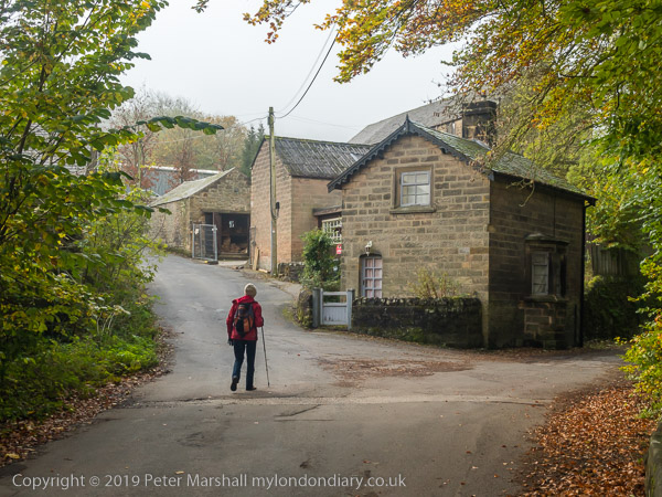
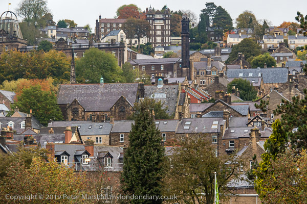
We had a day before we left Matlock when we were not looking after grandchildren and went on a walk. I’d been to Lumsdale before on my own at the end of 2018, but Linda hadn’t so we decided to walk up there .
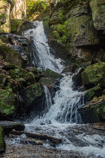
The beginnings of our Industrial revolution were driven by water power, before the age of steam, and valleys like Lumsdale were where it began. The Bentley Brook which runs down the valley is a relatively small stream, but the valley falls quite rapidly and its water flow could be harnessed by a series of mills on its descent.
Importantly, its flow was pretty reliable through the year, and could be maintained at a pretty constant level by damning its flow to build ponds at the top of the valley, two of which are still there, though the top pond above them is now dry.
We climbed gradually up the valley, going past the derelict structures of several mills. This picture is looking down from the top of the falls in the picture above, which was taken from roughly where you can just see a person in a red jacket. There are few places with any guard rails and the rocks were damp and slightly slippery, and I was hanging onto a small tree but still didn’t feel too safe, and had to move back from the edge.
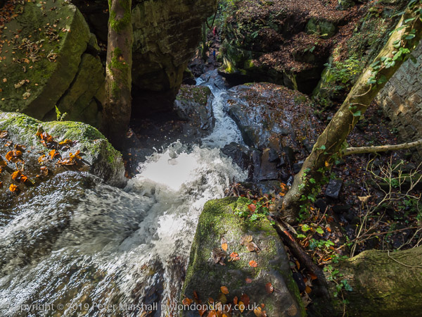
Higher up things seem rather safer, and the flow of the river more a result of man-made activities, including a dam to create a large holding pond. There is a second pond a little higher up the valley, and higher still I photographed the remains of another dam, which burst in 1947 and has not been repaired. There are useful explanatory boards at key points on the extensive site, but it remains for the most part open and unchanged for people to walk around, unlike some other ‘heritage’ sites.
We walked across from Lumsdale to Matlock Bank, stopping for lunch at the Duke of Wellington on the Chesterfield Rd before going down Rockside Steps and past the old tram depot to Bank Rd and down to the river.
It wasn’t a very long walk, but was full of interest, as I hope the pictures at Lumsdale & Matlock on My London Diary show.
All photographs on this and my other sites, unless otherwise stated, are taken by and copyright of Peter Marshall, and are available for reproduction or can be bought as prints.
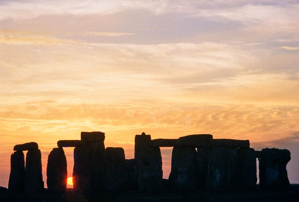
I woke up this morning just after 4am as I often do these days and made my way to the bathroom. A glimpse out of the window as I made my way back to bed assured me that there was little point waiting the few minutes until 04.26 to see the sun rise. And probably not to turn on the computer to watch that even live from Stonehenge, open this year only to a small team live-casting it to the nation and quite a large team of security guards. The sun, as English Heritage commented on Twitter was “elusive”, failing to put in an appearance.
I’ve never been to join the Solstice celebrations at Stonehenge, though I have visited the site on several occasions, the first as a young teenager when ‘Group’ pulled up the lorry taking us to Scout summer camp in Cornwall by the side of the road and we jumped down and rushed towards the stones.
Earlier this year, going through my old slides, I came across the picture at the top of this post, taken I think around 1980. I remembered having made a number of trips to Wiltshire with a group of photographers, but had completely forgotten going to Stonehenge to photograph the sunset over the stones. Of course over the years I’ve seen so many pictures of the place, some more memorable than this.
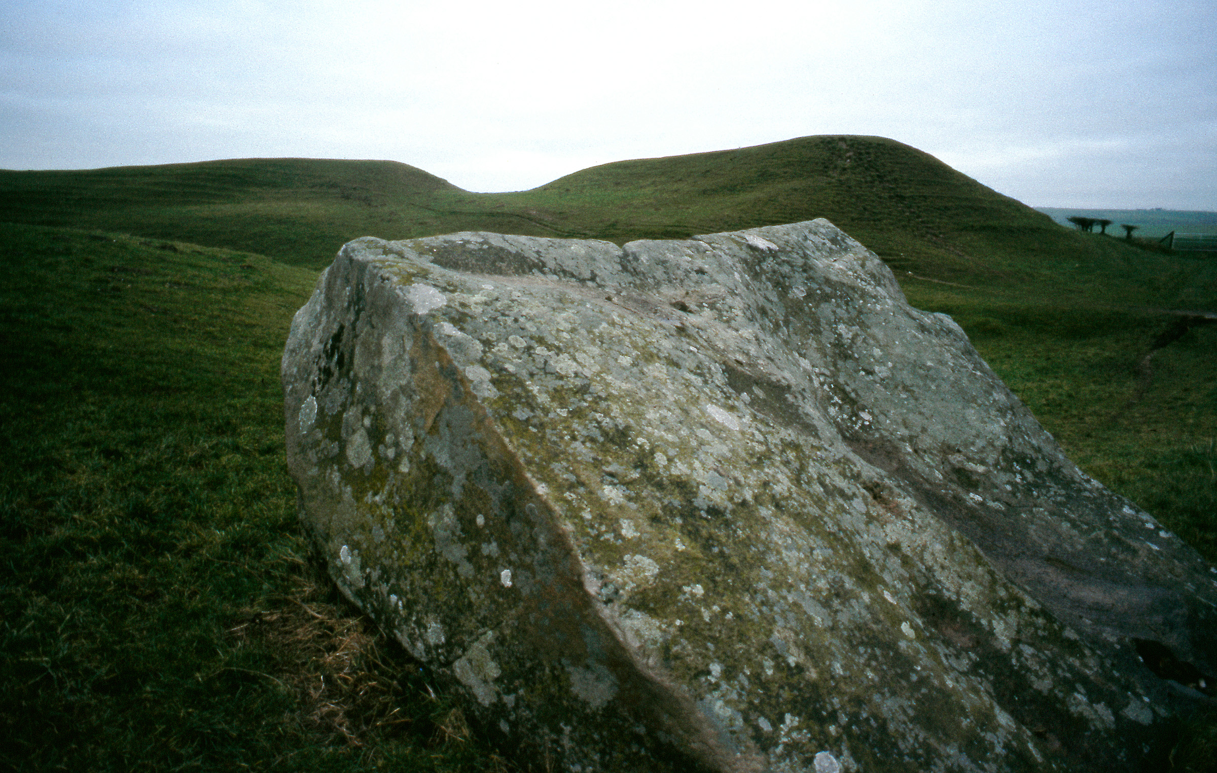
Although we drove by it on a number of occasions, I think this was the only time we stopped to take photographs, mainly concentrating on wider landscapes and on other mysterious and sacred sites including Silbury Hill and Avebury.
I found the circle of stones at Avebury perhaps more interesting than Stonehenge and visited them several times with the late Terry King, including at least one visit where we struggled to photograph them with a large wooden Kodak 10×8″ camera which he had on loan for several years to make large negatives for alternative printing processes. We’d learnt to use it in my back garden and by the Thames not far away, almost mastering its movements and the sequence of operations, and I acted as his unpaid assistant for several trips including to Avebury.
It would have been Terry who took us to Stonehenge too. I’m not sure if we were inside the fenced area to take the pictures, but if so I suspect he will have used his many connections to get us inside free of charge, perhaps as official photographers. Though I think the 10×8″ probably stayed in the car boot on this occasion.
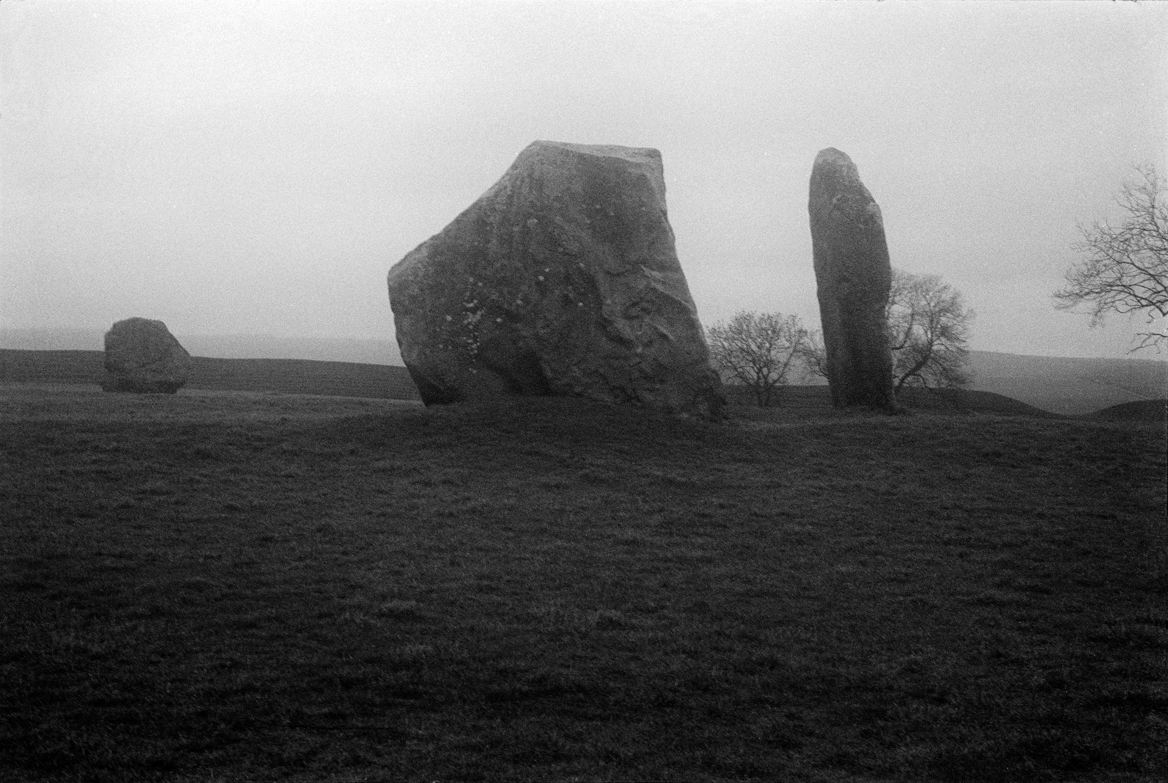
Like many of the colour transparencies I took in the 1970s and 1980s the two here have deteriorated over the years in storage, and both required extensive digital retouching. But though there were local patches where mould had damaged the images, the overall colour remained. With many of my slides of Avebury, fading of the colour pigments has made recovery impossible. I did make a few black and white pictures, like that above – made inside a damp mist covering the area which seemed to suit the subject.
All photographs on this and my other sites, unless otherwise stated, are taken by and copyright of Peter Marshall, and are available for reproduction or can be bought as prints.
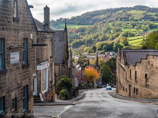
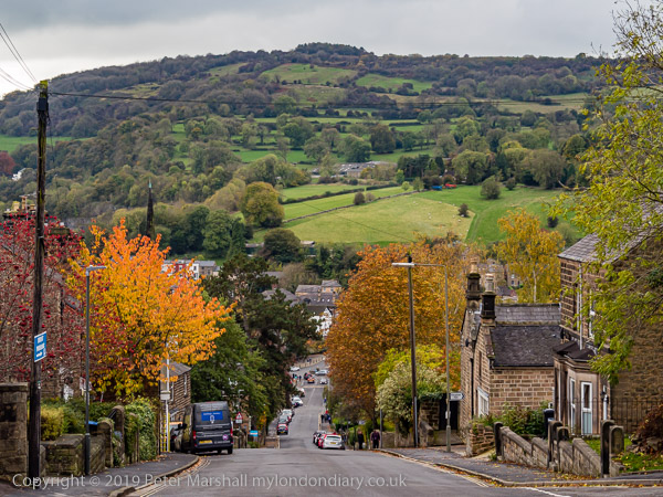
Last October seems now so long ago. Linda and I had gone to Matlock to look after two of our grandchildren for a couple of days in what turned out to be a small family emergency.
I took a few photographs on the walk back from taking the girls to school, and then went out later in the day for some exercise. Matlock is a pretty hilly kind of place, so I got plenty of it.
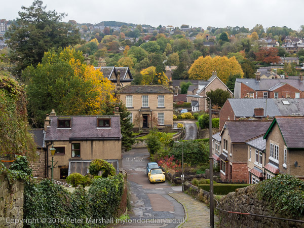
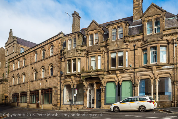
Matlock Bank is an area on a hill that rises up from the riverside at the centre of Matlock, with Bank Road rising pretty steeply up the hillside. It doesn’t have any banks on it, though there are some shops, the post office and police station close to the bottom, several churches higher up as well as offices for the local council and, close to the top those for Derbyshire County Council in what used to be Smedley’s Hydro.
It was this hydro, and other similar smaller establishments that made Matlock the town it is, and the spa became an important tourist centre in the nineteenth century. I knew, having done my research earlier in The Crown.
In 1893 a cable-hauled tramway opened on Bank Road, “Tuppence up, Penny Down” for the ride up around 300ft of hill on the world’s steepest tramway on public roads, a gradient of 18% – 1 in 5½. Unfortunately it was closed in 1927, with the council who ran it replacing it with a motor bus service.
There are still buses. Occasionally, though I didn’t see one while out for my walk. But I was glad I hadn’t brought my bike. I just don’t have the gears forgetting up 1 in 5½ – or the brakes for going down.
There are many pictures on the fourth and last page of my album TQ31 London Cross-Section I’d like to show you and say a little about, though in most cases they need little text, but it can sometimes add interest. But my time is limited and I’ll leave you to discover most of them for yourselves.
I think Andreas’s Barber Shop on the Hornsey Road had probably ceased trading by the time I took this picture, as there is no light bulb in the socket just to the left of the centre of the window. There is a notice in the door that gives its opening times, but where it says ‘Closed’ I think this may have been permanent.
As I was still working full-time, many of my pictures were made at the weekend, often like this one on Sunday mornings, when most shops would have been closed. The building is still there, but not the shop or its shopfront; the whole row of shops present when I was taking pictures has now been converted to residential use.
Rather to my surprise, this industrial/commercial building is still there on Drayton Park, and, at least until recently, the name ‘HOO HING LTD’ was still present above the doorway. The company still exists and is an importer of oriental food and catering products, but the site was reported as due to be cleared in 2006 for housing. However in 2019 it was still there; like many redevelopments it may have been halted by the financial crash.
Sisters Gowns was at the rear of a property at 216 Seven Sisters Road in Finsbury Park and this door was on Coleridge Rd. The property was demolished in 2008 (the sign had gone earlier), but the site was still empty in 2019.
Fonthill Rd in Finsbury Park, apparently known to locals as ‘The Font’ is possibly London’s best ‘fashion village’. On weekdays the trade is (or at least was) largely for the trade, but on Saturdays it becomes a busy retail fashion area, often packed with women on the lookout for a bargain. Fortunately most of the shops were closed when I went to take pictures on a Sunday morning.
A unisex hairdressers at Turnpike Lane excited me in my hunt for heads, with a couple of fine examples as well as some photographs. I think I took rather more pictures than the three you can see here. A recessed doorway meant I could work from several angles.
Close to Turnpike Lane, down West Green Road, I came across another interesting shop window for a tailor’s shop, offering best styles made to measure at local prices. Working with a single lens reflex camera with its through the lens view meant that I could clearly see how the reflection and direct view combined, and could make small movements and sometimes deliberate shading to control the effect.
TQ31 London Cross-Section includes almost 400 pictures made in a small sliver of London, just a kilometre wide, which reflect the different areas it passes through from Norwood in the south to Wood Green in the north. The pictures come from just one of around a dozen such albums containing colour pictures I took when working around London between 1986 and 1992.
All photographs on this and my other sites, unless otherwise stated, are taken by and copyright of Peter Marshall, and are available for reproduction or can be bought as prints.
I found this head in a barber’s window on New Bridge St fascinating if rather revolting and made several pictures of it and a similar head in another of the shop’s windows. At £11.95 for Mens Shampoo Cut and Finish back then (£25 at today’s prices) this was an establishment catering for the relatively wealthy, though women may think it still a bargain compared with what they pay. The company which had a number of shops is still in business but not at this address.
Curiously this little area of central London remained largely as it had been left after the war when I photographed here in 1992. The Queen’s Head was left alone after bombing in 1940 destroyed its neighbours, the Blue Last pub, the Ventura Restaurant and a stamp dealer in Ludgate Broadway. Fifty two years later their empty spaces only in use for car parks. Although I’ve labelled it on the enprint as Ludgate Broadway, a sign on the boarding around the bomb site reads Blackfriars Lane, but the view continues down f Ludgate Broadway to Pilgrim St. The size of the tree in the bomb site gives some indication of how long this site has been empty, though I think the ground level was some way down on the other side of the fence. The red building in Pilgrim St is still there, the 1891 City Bank with a frontage on Ludgate Hill, and had recently been restored at the time of the picture. A year later Ludgate Court on its west side was renamed Pageantmaster Court. The ugly block to the left of the City Bank has since been replaced by an even uglier one, but both this and the Old Bailey are no longer visible from where I was standing after the bomb site was redeveloped, I think around 2000.
Apart from the colour which seemed appropriate for the trade, I was certainly attracted by the painted brickwork around the door and the signs, both for ‘B. W. Bellgrove (Meat) Limited – Wholesale. Retail & Catering Butcher’ which seemed unusually explicit, and also for the street name, Eagle Court, which made the location clear. Eagle Court is a short distance to the north of Smithfield Market, and runs between Britton St and St John’s Lane.
Designed by Berthold Lubetkin in 1938, the foundation stone was laid in 1946 and the scheme completed in 1949, the Spa Green Estate between Rosebery Avenue and St John St in Clerkenwell is perhaps the most complete realisation of the modernist approach to social housing and a power expression of the new welfare state. It’s special status, confirmed by Grade II* listing in 1998 has enabled the estate, which had begun to deteriorate as government policies turned against council housing and made it difficult for local authorities to properly maintain it, has enable the TMO now responsible to carry out internal refurbishments to modern standards (and in many ways the original was well ahead of its times) and to restore the exterior to reflect Lubetkin’s original vision.
Wigton House on Agdon St in Finsbury. The street used to be called Wood’s Close, but at the start of the 20th century was renamed Northampton St, and then in 1939 the Marquess of Northampton (whose Compton family were the local landowners) was asked to suggest a new name for it and suggested Agdon St after property his family owned in Warwickshire. Back in the middle of the eighteenth century people apparently used to gather here to travel with an armed escort into London because of the danger of being robbed.
This was the rear entrance to Wigton House, whose frontage was on St John St. It was built by John Laing & Son Ltd in 1936-8 as a speculative development and named after Wigton in Cumbria, the area where the company came from. The building was converted into flats shortly after I took this picture in 1992 and renamed Paramount House. The frontage on St John St was altered but this side remains clearly identifiable.
The album TQ31 London Cross-section contains many more pictures from the City and Finsbury as well as areas both to the south and north, all made in the 1km wide strip with Grid reference beginning TQ31, all made between 1986 and 1992.
June 4th I took it easy again on my ten-mile ride, forcing myself to stop and take pictures here and there. Of course the stopping and starting does actually add to the amount of energy expended and I find it hard to actually waste the effort I’ve made by braking, so the places I stop are sometimes more determined by where I need to slow down for other reasons.
I’d changed my route slightly to go along a little of the River Thames towpath through Laleham village. I don’t like cycling along this bit of the towpath much, partly because its often quite busy with walkers, but mainly because the loose chippings on the actual path are a nuisance. Years ago, as a teacher hurrying along here on my way to an early morning in-service training meeting at the Runnymede Centre in Chertsey a stone flew up and into my chain, snapping the fairly chunky aluminium arm of my Campagnolo rear derailleur. I couldn’t ride the bike but rushed home pushing it, and picked up my wife’s bike to ride to the session. Fortunately I’d left home early to enjoy the bike ride, and ended up only a few minutes late. But I had to buy a new derailleur, opting for a rather cheaper model that seemed to work just as well.
This time I took the path in a leisurely fashion, keeping as far as possible to a narrow hardened mud area to one side of the chippings to arrive at the parking area where I stopped to take a photograph before proceeding.
One of many unfilled gravel pits in SpelthorneChertsey Lock and Chertsey Bridge
The narrow path soon becomes a metalled road, which would provide a pleasant ride beside the river to Chertsey Lock and Chertsey Bridge, though marred by the traffic humps and the occasional rather dangerous pothole.
The house where Zane died
Just before the bridge is the house where during the 2014 floods a tragic release from landfill of deadly hydrogen cyanide killed a seven-year-old and paralysed his father. Zane Gbangbola’s parents have continued the campaign to get the truth about the incident since.
Chertsey Lock
At the bridge I turned left towards Shepperton, along a busier road with a road surface curiously resistant to bicycle tires.
House, Dockett Eddy Lane Pharoah’s Island can only be accessed by boatShepperton Ferry – not currently operating.
It was a pleasure to turn off down Docket Eddy Lane which leads back down to the river, and past the houses on the riverside and on Pharoah’s Island to Shepperton Lock and the ferry.
I turned off the route into Church Square and went down to the garden by the riverside, to find a pair of fancy ducks with a small group of chicks. I switched to my longer lens so as not to disturb them while taking pictures.
Back on my bike I rode up Shepperton High St, turning left at the top to go over the M3. It’s always just a little of a struggle up this bridge, perhaps because its usually against the wind and very open, but there is a long downhill stretch after it, with little need to pedal until just before the next traffic lights. I kept on and was soon cycling through Laleham on the road and up towards Staines, over some more resistant road surface and some really poor cracks and holes at the roundabout by the pub I still think of as the Lucan Arms, though it has changed its name several times since Lord Lucan went missing. Nowadays he could easily disappear through a Surrey pothole.
All photographs on this and my other sites, unless otherwise stated, are taken by and copyright of Peter Marshall, and are available for reproduction or can be bought as prints.
A few pictures recently posted to my Flickr album TQ31 London Cross-section from colour pictures taken in 1979-85. These come from National Grid squares TQ3176 – TQ3181, part of the 1km wide south-north strip TQ31 through London.
Angell town got its name from the family who owned it in the 18th century, and in particular John Angell who died in 1550 and whose self-made will and various litigious claims due to his eccentricity and inflexible obstinacy resulted in years of legal argument after his death, and more after the death of John Angell, junior, in 1784. There were few houses on the land until it was fully developed in the 1850s by the redundantly named Benedict John Angell Angell, mainly with substantial semi-detached properties for middle-class families. St. John’s Church, Angell Town was consecrated in 1853.
Most of the estate around it was demolished and replaced by a council estate built by Lambeth Council in 1974-78. A combination of unfortunate design, typical of the time, and poor maintenance quickly led to the estate becoming a haven for drug dealers and other criminals. A comprehensive redevelopment in the mid-1990s led to some improvement but the estate later deteriorated, partly because of lack of support from Lambeth Council, and became the home turf of one of London’s most notorious teenage street gangs.
This café, the “IDEAL” was on the west side of London Road, north of the Elephant and Castle and just south of St George’s Circus. In the reflection you can just see a part of the Duke of Clarence pub, still there though now the Clarence Centre for Enterprise and Innovation of London South Bank University. The row of shops containing the café is still there but the shop fronts have changed and I can’t positively identify exactly which has replaced this.
When I put this project together, beginning around when I took this image in 1987, I was interested in the way that colour negative film and the cheap en-prints that were the normal way most of its users experienced it presented reality and distorted it. I liked the way images were often printed with strong colour casts and sometimes slightly out of focus, though this batch was one of the better in terms of print quality. Some processors also put little stickers on prints giving advice where they thought there were technical problems, one of which I’ve failed to remove entirely from this image at bottom left. I’m sorry I didn’t leave it on, as I can now only imagine what it said. I think either a warning about reflections or possibly against double-exposures – which of course this isn’t.
Joseph Cubitt who designed Blackfriars Bridge also designed the railway bridge which until a few years before I took this picture ran across the top of these piers, and had to make both bridges with the matching spans and piers, though those on the road bridge have a very different finish. His rail bridge for the London, Chatham and Dover Railway was opened in 1864 and the road bridge five years later.
The railway bridge to the east, on the left of the picture was opened some years later in 1886 and is still in use. But the station (originally called St Paul’s Station, but since 1937, Blackfriars) became less important when the Southern Railway was formed in 1924, with its main-line services being moved to Waterloo and the older bridge was no longer much used. In 1985 the superstructure was removed as it had become too weak to support modern trains, but these massive pillars were left, with some being used to support an extension of the station platforms across the Thames.
The Blackfriar is a remarkable example of a Victorian pub, Grade II* listed, on Queen Victoria St. Originally built in 1875 on the site of a medieval Dominican friary it was extensively remodelled in several stages beginning in 1903 in a jolly arts and crafts manner by Herbert Fuller-Clark, with sculptures by Nathaniel Hitch, Frederick Callcott, Henry Poole, and Farmer and Brindley. Their work was completed by 1925, but the large figure of a black monk over the corner door was only added a year or two before I took these pictures.
The pub was saved from demolition in the 1960s by a public campaign led by Sir John Betjeman.
The Wig and Pen club at 229 Strand was in a building from 1625, built on Roman ruins which claimed to have been the only building in the Strand to escape burning in the Great Fire of London in 1666.
Opposite the Royal Courts of Justice in its early years it was occupied by the Gatekeeper from Temple Bar, just along the street on whose spikes severed heads of traitors were displayed, and began to sell food and drink to the crowds who came to view them.
The club was formed as a meeting place for lawyers and journalists probably around the start of the twentieth century, and closed around ninety-five years later in 2003. Business dropped drastically as the newspapers moved out of Fleet St, but there were also changes in social behaviour making the lengthy and very liquid lunchtimes that were once the norm largely a thing of the past. It tried to keep going by making the lower floor restaurant open to the public, but even this failed to generate enough to keep the club going. Eventually after being vacant for several years it was sold by the landlords to a restaurant chain with the upper floor of this and the adjacent building being converted into a house.
The George Hotel, 213 Strand, was George’s Coffee House from up 1723 to the 1820s, becoming the George Hotel in the following decade. The building was on the site of an older building and was I think rebuilt in the Victorian era as a handsome stone-faced block on four floors with a balustrade across the front of the roof.
That building was ‘tarted up’ in 1930, with various additions to the woodwork of the ground floor, a half-timbered frontage and a pitched roof. I suspect that most of the antique internals also date from that facelift.
As a coffee house it claims many great historical writers as regulars, including Horace Walpole, Oliver Goldsmith and Samuel Johnson, and its basement is said to be haunted by a “Laughing Cavalier” or “Roundhead”, according to some accounts headless.
No-one seems to know why the additions to its frontage include an apparently naked man chasing half a dozen pigs or the monk with cat and barrel, though they are possibly copies from some older pub in what was something of a movement to recreate the old inns of England.
All photographs on this and my other sites, unless otherwise stated, are taken by and copyright of Peter Marshall, and are available for reproduction or can be bought as prints.
On the New York Times web site you can see an extended interpretation of the image used on the cover of what is probably the most iconic of all photographic books, Robert Frank‘s ‘The Americans‘, published in the USA in 1959, A Portrait of America That Still Haunts, Decades Later, by Arthur Lubow.
On the first publication in France in 1958, publisher Robert Delpire had insisted on using drawings on the cover by Saul Steinberg, as well as including published texts about America by well-known authors on all the left-hand pages, which Frank had wanted left blank. So far as I’m aware, all published versions of the book (with the exception of the 50th anniversary Looking In: Robert Frank’s The Americans which contains a huge amount of extra related material ) have followed Frank’s wishes with the pictures facing largely blank left pages (with just page numbers and brief caption) and used his picture of choice, Trolley, New Orleans 1955, on the cover.
Lubow’s close reading of the image is something rather unusual in photographic writing, where too often those who write criticism appear to have done almost anything to avoid actually looking at the pictures. We may find other references than some of those he finds – our responses like his are to some degree individual, dependent on our own experience and knowledge – and sometimes may feel he is stretching a point, but it is a powerful and useful reading.