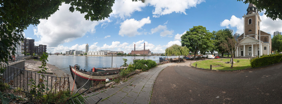
Battersea Riverside. The short walk from Battersea Bridge to Wandsworth is one I’ve done quite a few times over the years. For most of the walk you can now keep to the riverside, with views across the Thames, though a few short detours are needed. It’s on of my favourite walks in London and only a couple of miles, though if you want a longer walk it is now part of the Thames Path so you can continue for many miles either upstream or down.
Lots Rd
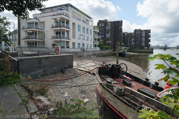
When I first made this walk in the 1970s the riverside was lined with industry and I could only access the river at a few locations. By 2012 the industry had almost all gone and there were blocks of private flats along most of this length. But ‘planning gain’ meant a riverside path even if it was lined behind by planning loss.
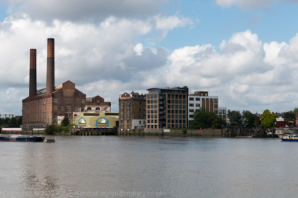
Thames at BatterseaSt Mary’s BatterseaOld Swan Wharf
People have to live somewhere and London needed extra housing, though almost all of these new developments were the wrong kind of housing and not the social housing desperately needed by Londoners. Back in the early post-war years we saw social housing being built to provide mixed communities and promote social cohesion, but Thatcher changed all that, and social housing became something only for the poor and that stigmatised residents as failures.
Overground train on its way to Clapham JunctionDemolition at Fulham WharfNew Flats and Wandsworth Bridge
The loss of industry also meant the loss of jobs in the area, and took place at a time of increasing gentrification in Battersea, with people moving in who worked in wealthier parts of the city.
Looking upstream from Wandsworth Bridge
As I wrote in 2012, “Every time I walk it a little more has gone with a new block of flats or hotel or other luxury development. But a few things remain.”
Waste transfer station, Wandsworth
You can see the panoramic images larger by right clicking on them and choosing Open Image in New Tab’ More pictures on My London Diary at Battersea Riverside.
A short distance down Spencer Road I turned right into Elsynge Road, a street full of large mainly semi-detached Victorian houses. It got its current name only in 1937, when Park Road was renamed to distinguish it from other Park Roads in London, including one not far away close to Battersea Park.
Local legend has it that some of the houses in this and Spencer Road were built for the Great Exibition of 1851, but in fact development only began in the area a little later, with the first houses in Spencer Road appearing in 1853-7 and in Park Road in 1856-7. Most were built in the 1860s with a handful of later additions.
The area draft Conservation Appraisal Document notes “Nos.9-11 and 13 are of particular interest, being of three and a half storeys with rustication to the lower storeys, canted bays, and projecting porches supported by Corinthian columns. Dentil cornices and decorative architraves to windows add richness of detail.”
As for the name of the house it could refer to one of the various Earl Stanhopes several of whom were prominent Tory politicians, one of the two English and one Scottish villages of that name, or be simply the family name of the residents.
House, Elsynge Rd, Wandsworth, 1989 89-8c-41
The draft Survey of London tells us that the area was initially called the Clapham Station Estate, named after a short-lived station on the line to the east of the area, not Clapham Junction which was only built in 1863.
Number 33 and 35 are rather plainer houses in the street but still large with a basement and three floors above. 35 is unusual for being one of few detached houses in the street and its current valuation is over £4 million. Both were build by the same builder, Richard Down a joiner from Princes Street, Westminster around 1863.
There are six of these large pillars in front of the impressive edifice Elsynge Mansions at 19-23 Elsynge Rd. The Survey of London suggests that this was built as a semi-detached property and converted into flats by the 1890s, a date when the building of mansions was becoming common across London.
Its name will have come from the Tudor Elsynge (or Elsyng) Palace in Enfield which had been used as a hunting lodge by Henry VIII but was part demolished in 1608 and completly not long after; it later became part of the Forty Hall estate. Its exact location had been lost until redicovered from 1960 on by the Enfield Archaeological Society. And clearly it was this name – in some elegant tiling on its front path – which led to the new name for Park Road.
Services Rendered Club (Battersea) Ltd, 4 North Side, Wandsworth Common, Wandsworth, 1989 89-8c-31
At the west end of Elsynge Road I turned into Marcilly Road, photographing a house there (not yet digitised) and walked down to the South Ciercular Road on the north side of Wandsworth Common. These buildings are still there at 4 North Side and are now home to Bright Horizons Day Nursery and Preschool.
There are still a number of Services Rendered Clubs in the UK and I think most of them were formed in or immediately after the Great War particularly for ex-servicemen who had been honourably discharged after becoming permanently unfit to serve. They were awarded the Silver War Medal, also known as the ‘Services Rendered Badge’, a lapel badge designed to be worn on civilian clothing. During the war this would have protected them from being harassed to serve ‘King and Country’. Most also got a printed King’s Certificate of Discharge.
According to the survey of London this was the coachhouse for Devon Villa, “designed by G.H. Page for G. H. Swonnell, maltster, and built in 1861, probably by George Bass“. The former Servicemen’s Club was converted into the nursery and 7 flats in 2005-6..
Pistons, 99, St John’s Hill, Battersea, Wandsworth, 1989 89-8c-33
I walked up Strathblaine Rd and Sangora Rd but took no more pictures until I turned into St John’s Hill where Pistons, a shop appearing to sell accessories for motorists including numberplates, warning triangles and superglue with a rather phallic sign caught my eye.
The shopfront is still there but for some years this was a furniture shop, ‘inform’ selling Scandinavian designs but the shop here was recently advertised for rent. The advert dated the shop as 1900 but it was built as part of the Strathblaine area development around 1882-6. Never believe what estate agents say.
I took a short detour down Strath Terrace, across the railway bridge and down Boutflower Road. Henry Boutflower Verdon was the first vicar-designate of St Mark’s, Battersea Rise and was much loved in the area by the time he died at the age of 32 in 1879.
A curate under Canon J. Erskine Clarke, Vicar of St. Mary’s Batersea, Verdon was to become Vicar of St Mark’s which was then being transformed from a tin tabernacle a Victorian Gothic church by William White, now Grade II* listed. The new church was dedicated as a memorial to him and Philip Cazenove, a local benefactor who had paid for the building of the church school.
Boutflower’s name was given to the road when Alfred Heaver developed what he called the St John’s Park estate in 1885–9. Heaver must have had a huge production line making these faces in the picture to be spread liberally across the estate. Probably he made a nice profit selling them to the builders.
It was time to end this walk and make my way to Clapham Junction for the train home. It was August and I was shortly off on my travels to Hull, where my next frame was taken and later on to a week in Scotland. So my next walks were rather different.
I turned south from York Road into Petergate and turned int Eltringham Street where I think I took this picture of the Charterhouse Works. It’s hard to read the peeling paint of the notice on the side, but I think these were once the works of Sandle Brothers, Manufacturing Stationers, Wholesale & Export with City Offices & Showroom at 4 Snow Hill EC4. You can see more about them on Spitalfields Life.
There appears to be a very long list of current occupants on the front of the building and on the full size image I can make out some of the names of what appear to be small businesses with workshops or offices in the building.
I think this is now the site of Charterhouse Appartments at 21 Eltringham St, a large modern block.
I made my way through the back streets to Plough Road, probably going along the footpath beside the railway line, Tours Passage. On the way I passed a heap of black sacks of rubbish with horse that had come from a fair roundabout, which I photographed but have not yet digitised.
Going under a railway bridge and walking down the road took me opposite the works of Nicholson & Co Ltd at 115-7 Plough Road, Heating – Ventilating – Air Conditioning Engineers established in 1904. Next door at 119 is a rather more ornate building with the date 1902 in its gable. The 2013 Survey of London tells me this was a former diary “designed by William Clinch Poole for the Dairy Supply Company Ltd.”
Plough Road School is Grade II listed as Highview Primary School and was built in 1889-90 (the date 1890 appears on it though not in my picture) designed for the London School Board by its architect T J Bailey who was proud of his work and exbibted the designs at the Royal Academy in 1891.
My view is of the back of the building, probably because much of the rest was covered by scaffolding when I made it, but perhaps becuase I thought the architectural influence was more evident. At the right of my picture is a little of the schoolkeeper’s house built at the same time.
St Pauls, Church, Community Centre, Vardens Rd, St John’s Hill, Wandsworth, 1989 89-8c-54
At the bottom of Plough Road I turned right into St John’s Hill and took this picture of St Paul’s Church from the corner of Vardens Road, I think to contrast the slender spire with the pillars of the corner doorway of 129 St John’s Hill. This block, shops with flats above has a rather more delicate entrance to the flats, Harvard Mansions, on Vardens Road. Those pillars seemed unusual in that they clearly were not supporting anything – with a top looking like a chimney. The block was built in the late 1890s in an Arts and Crafts style.
Although this is on St John’s Hill it was built in 1868 as St Paul’s church, as a part of the parish of St John’s Battersea which was on Usk Road. It was needed to accommodate the growing number of worshippers in the area which was beginning to expand rapidly. Later numbers fell and St John’s closed in 1950. This church became part of the parish of St. Peter & St Paul Battersea. Chad Varah who founded the Samaritans was its vicar from 1949-53.
Designed by H E Coe this Victorian Gothic church was build in a Decorated style using Kentish ragstone. Despite some on-line statements it appears to be only locally listed. When I made this picture it was in use as a community centre for the local residents association and as a nursery and it seems only to have been formally de-consecrated in 2013 to allow parts to be converted to flats.
I walked west to the next turning on St John’s Hill and went down Spencer Road where a short distance down I found these splendid Victorian villas. Much of the housing in the road is interesting but I was particularly interested in these for their combination of Victorian Gothic and Dutch gables.
Spencer Road presumably gets its name from the various Spencers who were Lords of the Manor in this area. The street was laid out before 1871 but was developed piecemeal and these houses are I think probably a little later.
St Peter & St Paul, Church, 121, Plough Road, Battersea, Wandsworth, 1989 89-8c-74
I left the riverside and walked down Lombard Road and crossed York Road into York Gardens probably to find a pleasant spot to rest a while and eat my sandwiches before going through the gardens to exit on Plough Road close to the church.
St Peter’s Church is still very much alive now on Plough Road, but SPB looks very different to my picture in 1989. The first St Peter’s Battersea was built in 1875 but was seriously damaged by fire in 1970 and the church moved into the building in my picture which had been its church and school hall.
According to ‘Clapham Junction Insider’ Cyril Ritchert, the demolition of this Grade II listed building, “an accomplished example of the free gothic style“, was opposed by the Ancient Monuments Society, English Heritage, the Battersea Society and the Wandsworth Society but was approved by Wandsworth Council in 2010. The developers made a second application in 2015 before any building on the site had started. Google Street View shows the church still in use in 2012.
To finance the new church the developers had been granted permission for an 8 storey block of flats also on the site. Local residents were angered that the developers managed to game the planning system to eventually build a 10 storey block of housing with minimal affordable housing on the site.
Shop, St Peter & St Paul, Church, Flats, Holgate Ave, Plough Rd, Battersea, Wandsworth, 1989
The view of the church from Holgate Avenue shows clearly the position of the church on the edge of the Winstanley Estate to the north of Clapham Junction station. The view of the tower block Sporle Court is now blocked by the new 10 storey block on the church site. The trees at left are in York Gardens.
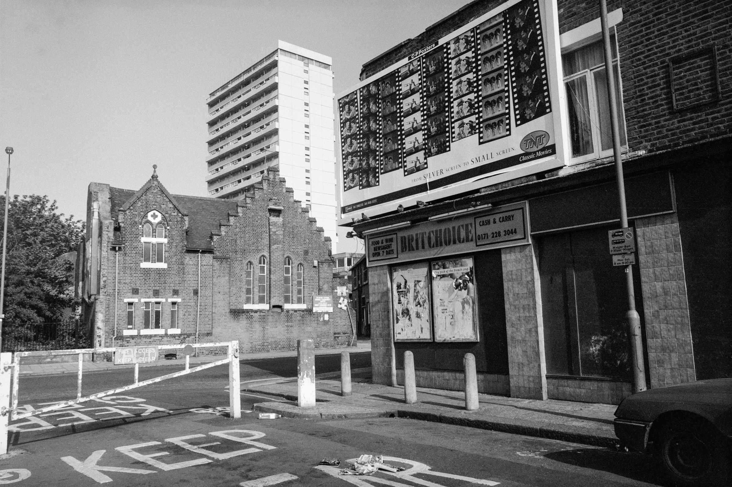
There is still a billboard and a shop on the corner of Holgate Avenue, but what was then BRITCHOICE is now SUNRISER EXPRESS POLSKI SKLEP. Holgate Avenue was until 1931 known as Brittania Place or Brittania Street and took its name from the Brittania beer house which was possibly in this shop, part of a group of two buildings at 38-40 Plough Lane which are the only remnants of the original 1860s development of the area.
Apparently the Revd Chad Varah, the founder of The Samaritans, was vicar at Saint Peter’s during the 1950’s. St Peter’s was amalgamated with St Paul’s at some time after 1969 – and St Paul’s had been amalgamated with St John in Usk Road in 1938.
According to the Survey of London, “Holgate Avenue, started in the 1920s, was Battersea’s first successful slum-clearance scheme.” Poorly built Victorian houses from the 1860s were replaced by these three-storey tenements built by Battersea’s Labour Council in 1924-37 to high standards with some impressive brickwork and detailing. Probably more importantly for the residents they were provided with electric cooking, heating and lighting facilities, unusual luxury for the time.
There was little land in Battersea for building and while the council would have liked to build single family homes it had to compromise with these. But at least tenants at most had only to walk up three flights of stairs, while most new council building by the LCC in the interwar period was in five-storey tenement walk-up blocks.
Price’s Candles, York Rd, Battersea, Wandsworth, 1989 89-8c-62
I walked back up Plough Road to York Road, and continued my walk towards Wandsworth Bridge. There was no access to the River Thames on this stretch before the bridge, as the area was still occupied by industrial premises.
Price’s Candles on York Rd was built on part of the site of York House, the London residence of the Archbishop of York from which York Road got its name. You can read more than you will ever want to know about York House in All about Battersea, by Henry S Simmonds published in 1882 and now on Project Gutenberg, which also has a long section on the Belmont Works or Price’s Patent Candle Factory.
Price’s Candles was begun in 1830 by William Wilson and Benjamin Lancaster who had purchased a patent for the separation of coconut fats. They chose the name Price for the business to remain anonymous as candle-making was not at the time a respectable occupation.
They moved to this site in 1847 setting up a large factory and workforce, making candles, soap and other products with stearine wax for the candles and the by products of glycerine and light oils coming cocunuts grown on a plantation they bought in Ceylon. In 1854 they began to import large quantities of crude petroleum from Burma and developed paraffin wax candles. Later they developed processes to work with other industrial wastes, animal fats and fish oils. By 1900 they were the largest candle manufacturer in the world.
The company was taken over by Unilever in 1919, and became owned by other oil companies including BP, who sold part of the site which opened in 1959 as the Battersea Heliport. A few of Price’s buildings remain, though most with added floors, and the rest of the site is mostly new blocks of flats.
York Tavern, pub, 347, York Rd, Battersea, Wandsworth, 1989 89-8c-63
The York Tavern was on the corner of York Road and Usk Road in the late 1850s but was given a makeover later in the century in the typical 1890s Queen Anne style with fake gable facades. I can’t find a date for the closing of this pub but it was clearly very shut when I made this picture. The building was demolished in 2003.
John Watney & Co Ltd, Wandsworth Distillery, York Rd, Battersea, Wandsworth, 1989 89-8c-64
Wandsworth Distillery on York Rd was founded by Richard Bush at Gargoyle Wharf around 1780. By 1874 it was owned by John and Daniel Watney. Gin was produced here, having become popular after heavy taxes were imposed on French brandy, and later particularly in the colonies to counteract the unpleasantly bitter taste of the anti-malarial quinine.
Acquired by Guinness, the distillery was demolished in 1992, and I photographed its occupation as the ‘Pure Genius Eco Village‘ by The Land is Ours in 1996. It was redeveloped as Battersea Reach housing from 2002 on.
House boats, Mooring, River Thames, Chelsea Wharf, Kensington & Chelsea, Battersea Church Rd, Battersea, Wandsworth, 1989 89-8b-35
The churchyard of St Mary’s Church is on the riverside and back in 1989 was the first place I could access the river in Battersea upstream of Battersea Bridge. The churchyard was closed for public burials in 1854.
The moorings here look rather crowded. At Spring Tides the river comes into the churchyard at high tide and I think people living on the houseboats here would need wellingtons, but the tide was low when I made this picture. On the west side of the churchyard is a slipway and past that was Church Wharf, part of Battersea Wharf. Immediately on the corner of the slipway until fairly recently was the Old Swan pub. Once a solid Victorian building it had been replaced in the 1960s by a strange building with much wooden planking and large windows which had become a punk venue in the 70s before closing, being squatted, and becoming derelict and then perhaps conveniently burning down. The block of expensive riverside flats which replaced the pub is named Old Swan Wharf.
St Mary’s, Church, Battersea Church Rd, Battersea, Wandsworth, 1989 89-8b-21
St Mary’s Church is a real gem, Grade I listed, built in 1775-77, architect Joseph Discon, though the painted glass in its East Window is said to date from 1631, attributed to Bernard van Linge and transferred from the previous church building on this site. The stonework around this window is even older, dating from 1379 when the church was owned by Westminster Abbey and they sent one of their masons over for the job.
Bomb damage in the 1940s gave the then vicar the chance to smash some of the “very bad Victorian stained glass” which made the interior gloomy and there are now four modern stained glass windows. One commemorates William Blake who was married here in 1842 and another J M W Turner who was rowed across from his Chelsea house each day and sat at the vestry window to paint his riverscapes. The famous 18th century botanist William Curtis is commemorated in the third, while the fourth is for the US “archetypal traitor” General Benedict Arnold, given by an American donor.
Houses, Battersea Church Rd, Battersea, Wandsworth, 1989 89-8b-24
At the extreme right of this picture is a sign pointing to the riverside walk which began next to the slipway beside the church and in the centre is the rather ugly riverside development of Valiant House, in 1971 one of the earlier blocks of luxury riverside flats. The Survey of London quotes it being described as ‘luxurious and dismal, a high security complex which afforded views of the river as well as the rubbish tips on Chelsea Reach’. It took its name from the former concrete works on part of the site at Valiant Wharf, and perhaps the only mitigating grace of the development was that it provided a narrow riverside walkway, though a little narrow.
The houses at left, probably mainly Victorian with various alterations now look rather different but the facades along the street remain.
Houses, Battersea Church Rd, Battersea, Wandsworth, 1989 89-8b-25
A few yards along the street with an attractive curve leading to Battersea Square the view here seems little changed now. You can see the Grade II listed Raven (no longer a Pub) just to the left of the traffic light.
Lamp post, River Thames, Chelsea Wharf, Kensington & Chelsea, Vicarage Walk, Battersea, Wandsworth, 1989 89-8b-13
The view across the river to Chelsea Harbour. Planning permission was granted for this huge riverside development in 1986 and building proceeded rapidly. By 1989 from across the river it seemed complete and very different to what Sands End would have looked like when Nell Gwyn lived here or when it was a coal dock for the gas works and railways. The old coal dock, became a somewhat shorter marina. The 18 storey tower was erected at a rapid pace, with at one point gaining a new floor every 4 days, and was topped out in six months.
The 310 luxury flats in the new development were marketed with prices starting at around £2 million per property and have 24 hour security patrols and porterage.
Being towed by a tug upriver are empty containers which have carried London’s rubbish away downstream and are now returning upstream to the refuse depot at Wandsworth for refilling with the barge sitting considerably higher in the water. I think this general waste now mainly goes for incineration at Crossness.
Battersea Railway Bridge was built in 1863 and has been strengthened and refurbished in 1969 and in 1992 after I made this picture.
It provides one of relatively few links between railways south of the Thames and those to the north and is used by Overground and mainline trains running between Kensington Olympia (and points north) and Clapham Junction. It is also used by goods traffic which could use Battersea’s extensive rail network to run almost anywhere in the South.
The stretch of walkway by the river leading here through the narrow Vicarage Gardens next to Vicarage Crescent had been opened up some years earlier. But there was still little access to the river beyond the railway bridge. Since then the riverside path now continues through one of the railway arches.
There are plans for a foot and cycle bridge across the Thames next to the railway bridge, but although a start has been made on this project and planning permission was given by both Wandsworth and Hammersmith & Fulham in 2013 I think funding remains a problem; but Wikipedia states ‘The forecast opening date is 2025, taking 18 months to build and audit.’
Battersea Park, Battersea, Wandsworth, 1989 89-8a-12
I’m not what was happening in Battersea Park, and perhaps I had arruved too early.
Battersea Park, Battersea, Wandsworth, 1989 89-8a-21
A tree close to the tent had a rather odd piece of fencing around it and I also photographed this, both with the tent and on its own, though I’ve not put that on-line. I walked on to the Peace Pagoda and took another three pctures – again not posted online, because it was rather better in colour – I think there are eleven images in the colour album for 1989.
Insect, Battersea Park, London, 1989 89-8c-73
And I still can’t tell you what was happening in the park, but here is a picture I think I took a little later before I decided to leave and continue my walk.
Josie 4 Arnie, Battersea Church Rd, Battersea, Wandsworth, 1989 89-8b-55
I returned west towards the centre of Battersea. Back in 1989 the riverside at Battersea was still lined with industry and there was no path west beside the river and I had to go back from the park along Parkgate Rd and then cross Battersea Bridge Road and walk along Battersea Church Road.
There my eye was caught by this rather odd graffiti – back then there was far less on walls in London. I couldn’t decode what the drawing on the wall was meant to represent and I still can’t. On one side of the dark box in the corner was a cartoon rabbit with two terms of affection ‘Hun’ and ‘Snoocums’ with more the more comprehendible message across its door with a heart and ‘JOSIE 4 ARNIE’. At right was an open gate and there were also some interesting shadows.
Rank Hovis Ltd, Battersea Church Rd, Battersea, Wandsworth, 1989 89-8b-42
On Battersea Church Road was the still busy factory of Rank Hovis Ltd although much of the other industry including the Morgan Crucible Company had already gone and its site replaced by housing, beginning at Morgan’s Walk estate in 1984.
The mill here had begun in 1788 with an unusual horizontal windmill built by Thomas Fowler to crush linseed for the oil for paints, but a few years later became used for grinding corn and barley. Around 1825 the mill was taken down and replaced by a steam engine. The mill grew and was eventually taken over by the Mayhew family in the 1890s as Mark Mayhew Mill.
Rank Hovis Ltd, Battersea Church Rd, Battersea, Wandsworth, 1989 89-8b-44
In 1914 the Mayhew’s business was bought by Joseph Rank and became run by Rank’s second son Rowland who used his father’s Hull architects Sir Alfred Gelder and Llewellyn Kitchen to reconstruct and enlarge the site. They managed to get the LCC to waive regulations on building heights to construct the largest grain silos in London so that a whole lighter full of grain could be unloaded at a time.
In 1962, Ranks acquired Hovis McDougal, becoming Rank Hovis McDougal, though by 1989 the McDougal seems to have disappeared. The mills were updated and produced up to 10 tonnes of white flour an hour, using mainly UK wheat delivered by lorry, though some came from Canada and was delivered by barge from Tilbury Docks.
The mills only finally closed around 1992, and were demolished in 1997; the site is now occupied by the tall triangle of Richard Roger’s Montevetro riverside flats, covered at some length by the Survey of London.
Dimson Hall Social Club, Battersea Church Rd, Battersea, Wandsworth, 1989 89-8b-46
Across the road to the south of the road in 1989 was the very different triangle of the Dimson Hall Social Club, part of the extensive Somerset Estate begun by the GLC in 1962 and completed by the London Borough of Wandsworth. This community centre was named after GLC councillor Gladys Dimson who was the GLC housing chair from 1973-77. A colleague of Ken Livingstone, she was also involved with both Shelter and the settlement of Toynbee Hall in East London.
Currently flats on the Somerset Estate are advertised at around almost couple of a million pounds less than their near neighbours in Montevetro.
The riverside developments on the river in Battersea although often controversial do mean there is now a riverside path along virtually the whole length. Back in 1989 there was I think no access for the public between Battersea Bridge and St Mary’s Church where the next post on this walk will begin.
The Raven, pub, Battersea Church St, Westbridge Rd, Battersea, Wandsworth, 1989 89-8a-56
Also at the edge of Battersea Square, on the corner of Battersea Church Street and Westbridge Road is The Raven pub, probably the most significant building in the area, built here in the mid seventeenth century and open as the Black Raven in 1701. Grade II listed it has had various alterations since then but is the only remaining pre-Victorian building in the area. Its value was recognised by a very early listing made in 1954, although it had been extenisvely rebuilt in 1891
Unfortunately this is no longer a pub, but Melanzana, a independent ‘bar-trattoria-deli‘ which according to Camra no longer serving any real beer. You can drink Peroni or wine with your pizza or pasta. I don’t think its interior retains anything of historic interest.
Another image about gentrification. I’d walked back east along Westbridge Road towards Battersea Bridge Road. I think this house was being converted into four flats. This was a significant area of early middle class development in the area in the 1840s with villas with long rear gardens in contrast to the much more downmarket development of what was rapidly becoming an industrial area.
This and its neighbour at 2 Westbridge Road are a pair of Grade II listed Gothic villas dating from 1845, just a few yards from the junction with Battersea Bridge Road. They are included in the Westbridge Road Conservation Area, much of which was developed by 1865. The appraisal describes them as “napped flint faced Gothic villas, quite unique in the district” and gives a further description of them along with a photograph from across the street taken in winter.
In August when I made my picture the houses were largely hidden by the leaves on the trees in their garden. But my view through the open gate does show the statue in the niche at the top of the building more clearly. The pair of houses also have an unusual front wall and gates.
Cranbourne Court, 113-115, Albert Bridge Rd, Battersea, Wandsworth, 1989 89-8a-45
A number of blocks of mansion flats were built in the 1890s on the edges of Battersea Park along Prince of Wales Drive and Albert Bridge Road, their position with views across of the park making them attractive to wealthier middle-class tenants who needed to live close to the West End. Chelsea was too expensive but this area was only just south of the river and not really in those dangerous areas where posher Londoners (and taxi drivers) feared to go. Apparently adverts for some of the new blocks gave their address as Chelsea Reach, Battersea – estate agents today are still often rather inventive in their descriptions of locations.
According to the Survey of London, almost 1,000 apartments were built here between 1892 and 1902.
The development here was suggested by architect and property speculator John Halley, who had moved south to London from Glasgow in the 1880s and had already put up blocks in Kensington. His plans were too dour for London, resembling Glasgow’s tenements, and he teamed up with another architect William Isaac Chambers who pimped them up for London tastes, though other architects made changes too as The Survey of London article recounts.
Cranbourne Court was one of the last blocks to be built, with Halley again involved along with one of his earlier co-developers, Captain Juba Page Kennerley, “a colourful character who had dabbled in a variety of dubious money-making schemes” and who was “indicted for theft and declared bankrupt” in the early 1890s. An undischarged bankrupt, he had set up a building company under an alias ‘Cranbourne & Cranbourne’ who built this block in 1895.
Albert Bridge, Battersea, Wandsworth, 1989 89-8a-31
Albert Bridge is a curious mixture, built as a modified cable-stayed bridge using the system patented by Rowland Mason Ordish and William Henry Le Feuvre in 1858. This made use of a normal parabolic cable to support the central span of the bridge but used inclined stays attached to the bridge deck and connected to the octagonal support columns by wire ropes to support the two ends of the load. Ordish’s designs, made in 1864, were only built in 1870-3.
River Thames, Albert Bridge, Battersea, Wandsworth, 1989 89-8a-35
When the Chief Engineer of the Metropolitan Board of Works Sir Joseph Bazalgette inspected in the bridge in 1884 he found corrosion of the staying rods had made the bridge unsafe and he added steel chains and a new timber deck.
In 1972 the bridge was again found to be unsafe, and the LCC added two concrete piers to support it in mid-river, turning the central section into a beam bridge, though the earlier cables and stays remain in place.
This was one of London’s earlier wobbly bridges (along with Battersea Bridge) and because of its closeness to Chelsea barracks a notice was attached to this “Albert Bridge Notice. All troops must break step when marching over this bridge.” It was feared that troops marching in unison could set up a resonance such as that which had been blamed for the collapse of the Broughton Suspension Bridge in Salford in 1831. The notices now on the tollboths date from 1965 but are said to be replacements of earlier notices on the bridge.
River Thames, Albert Bridge, Battersea, Wandsworth, 1989 89-8a-34
The view upstream from the bridge across the River Thames past Battersea Bridge to tower blocks on the 1970s World’s End Estate and the Lots Road Power Station.
I walked on into Battersea Park where the next post about my walk will continue.
My walk on Friday 4th August 1989 began at a bus stop on Battersea Bridge Road more or less opposite where I had caught a bus at the end of my previous walk
McCarthy Court is set just a few yards back from the road and I think this picture of it was possibly taken in Bridge Lane. Its two long blocks, one 4-storey and the other 2-storey were built for Wandsworth Council in 1978 with an inner garden between them and they contain 42 one bedroom flats and 36 two bedroom flats. The estate, now with a mix of council tenants, leaseholders and private tenants since 2005 has been managed by the McCarthy Court Co-operative whose board consists of estate residents with one council nominee. I assume McCarthy was the name of some local councillor or officer but perhaps someone in the area can tell me.
It had been planned, as the Survey of London recounted in 2013 as a part of a much larger development by the then Conservative government, but permission for much of this was denied by the Ministry of Housing and Wandsworth was told the houses over much of the site were sound and could be renovated. Writing about these pictures now I often wish that this survey had been available when I was photographing the area, as there were few published sources then.
Bridge Lane, Battersea, Wandsworth, 1989 89-7o-15
The first Battersea Bridge was a toll bridge which replaced a ferry across the River Thames to Chelsea and was opened to pedestrians in 1771 and to horses and carts the following year. Designer Henry Holland had been forced to cut costs and the bridge was narrow and dangerous both to users and river traffic, but with some reinforcement it lasted until 1885, the last wooden bridge over the Thames. This bridge was painted by almost every significant British painter of the age including Turner and Whistler.
Presumably Bridge Lane used to lead to the bridge, though it now stops short, and may in earlier times have led the the ferry. These houses on Bridge Lane are presumably Victorian and may have been among those saved from demolition by the Minstry of Housing in 1968, though I think these are what is now number 1 and 2 on the north side of the road, despite the number 9 in my picture and 15 on one of the doors.
Bridge Lane, Battersea, Wandsworth, 1989 89-7o-16
An interesting use of piles of bricks on top of both rectangular and cylindrical columns on the gate and steps to this house. I don’t think these have survived.
Back in the 1960s the Tate Gallery had paid Carl Andre a little over £2,000 for a pile of bricks, causing huge controversy over what many considered a waste of money. These seemed to me rather more interesting.
Bridge Lane ends at Surrey Lane and I turned west down it and then down Orbel Street. The estate here was built in the 1870s and 80s, and the northern side of Orbel Street is lined by semi-detached two storey houses with only vestigial front gardens.
You can stil see the short section of fencing between the two doorways of 70 and 72 on the street, unusually ornate for these houses, but the gate and the section fronting the pavement has gone. With the leaves from the shrub behind I felt I could almost be in the Palm House at Kew.
The House Hospital, 64, Battersea High St, Battersea, Wandsworth, 1989 89-8a-52
Not a medical establishment, The House Hospital at 64 Battersea High Street was for me symbol of the rapid and considerable gentrification of the area taking place as the industries were moving out. It offered replacement doors, at a price unspecified, fire places, baths, basins, taps etc. The site at 64-66 had built in 1975 for the factory of Allen and Ernest Lambert, who called themselves the Allen Brothers and made cigars. It later became a pipe factory for Imperial Tobacco until around 1930. According to the Survey of London “in the late 1950s they were occupied by the Ductube Company Ltd, makers of inflatable tubing for laying ducts in concrete.”
The building at right and the factory site behind has since been redeveloped as ‘Restoration Square‘. Number 64 and therather dull block at left, Powrie House, remain.
Bennett’s Brasserie, London House, Battersea Square, Battersea, Wandsworth, 1989 89-8a-55
James Bennett was a linen draper, who named his business premises very visibly ‘London House’. Originally in a Georgian building on the right of this picture he added to this in a matching fashion across the middle and left of my picture in 1866. I think the ground-floor addition of Bennett’s Brasserie is rather later. The builidng is locally listed. I think ‘London’ was perhaps a suggestion that he sold fine fabrics, not the coarser ‘Manchester’ cloth, as Battersea was clearly back then not in London.
Gordon Ramsey took over the Brasserie in 2014 as a restaurant, but this closed in 2022.
Battersea Square had more or less disappeared off the maps by the 1970s, but the name was restored and considerable work carried out on the area after it was designated as a Conservation Area – the work was more or less complete when I made these pictures in 1989.
More from Battersea in a later post about this walk.
The passage was probably built around 1859-63 when the West London Extension Railway was built, disrupting a local route that links what is now Cabul Road with Sheepcote Lane on the eastern side of Latchmere Road.
The railway was an important route crossing the Thames and the three lines that cross Latchmere Passage, each on its own viaduct and bridge, link it to the lines into Waterloo, to the north platforms of Clapham Junction serving lines out of Waterloo and those on the south side for the lines out of Victoria. The latter two bridges are now used by Overground and Thameslink trains.
Cabul Road is part of the estate here and to the west of Falcon Road developed as the Falcon Park estate by Alfred Heaver in 1879 – 1881, with street names taken from the battles of the Second Afghan War (1878–80) and the 1879 Zulu War. Almost all of the area was covered with small two-storey terraced houses, with the exception of this 1885 Milton Congregational Hall, designed by Searle & Hayes in a restrained Queen Anne style.
Congregationalists had worshipped at Milton Hall, Battersea since 1873, presumably in some earlier building and after its congregation combined with Battersea Congregational Church in the 1930s had various uses including as a film studio. It was recently redeveloped, retaining the facade, as residential properties.
A large part of the area was damaged by wartime bombing and after the war converted to open and rather featureless green spaces, Shillington Gardens and Falcon Park.
This is one of three semi-deatched pairs of houses on Falcon Road which date from around 1850 when the area began to be developed by William Willmer Pocock, an architect and prominent Methodist and Thomas Daniel Carter who owned much of the land. Carter had sold some of the land to Pocock as containing brick earth, and Pocock set up the Falcon Brick Works here. But the bricks were not too good and the area soon began to be built over.
Next door to the dentists was Grove End House, also built around 1850 and now rather altered as the Battersea Mosque.
Knowsley Rd, Battersea, Wandsworth, 1989 89-7o-24
I realised then that I had missed out the Poyntz Road triangle, a small triangle of roads between the railway lines to the east of Latchmere Road, and I retraced my steps to Latchmere Road, then crossed over into Knowsley Road.
The picture shows the end of the road just beyond its junction with Shellwood Road. The houses here were built in the 1870s and seem little changed now. The archway led through to a yard with buildings around it, I think workshops, though there is now a more recent block of flats. The Overground from Clapham Junction to Wandsworth Road runs on an embankment to the right of the houses here.
I took a couple of pictures on Latchmere Road, not on-line, and continued north up Battersea Bridge Road, where I made this picture of a doorway with a rather flimsy-looking railing and what appears to be a fairly subtantial tree. The house and doorway are still there and in rather better condition but there is no sign of the the tree and its hard to see where it could have been growing.
By now I was looking for a bus stop to take me back to Clapham Junction, just a few yards further up the street. This was the end of my walk in July 1989 though I returned to Battersea a few days later.
Thes two handcarts on Ashbury Road close to the corner with Grayshott Road took me straight back to my childhood. Tradesmen commonly used such carts to carry their equipment and materials around the streets back in the 1950s, and my father continued using his until he retired in the late 1960s whenever he needed more than he could carry on his bicycle.
Ladders, bricks, tiles, sand, plaster, tools, cookers, fridges, bee hives and more would be carted around the streets of Hounslow and neighbouring areas. Dad never owned a car or a van, though in his youth he had ridden a motorcycle. Sometimes I would be recruited to pull the cart, and when younger still I sometimes got a ride on it when he had to look after me while he was working as a plumber, painter and decorator, electrician, plasterer, bricklayer etc. Though social services now would have a fit if he took me up with him to keep an eye on while he was roofing.
And as a Boy Scout in my teens I sometimes helped to pull a trek cart loaded with our camping gear for a weekend at Chalfont St Peter, setting off along busy main roads for around 15 miles to the camp site.
The doorway at left is on the corner of Grayshott Road and Eversleigh Road, where above the porch on the other side of the road is the date 1878 and the intertwined initials of the Artizans’, Labourers’, & General Dwellings Company. I’ve written in earlier posts about the company and you can also read a much more detailed account in the Survey of London’s Shaftesbury Park Estate chapter.
A closer view of the porches on some of the houses on Eversleigh Road – these are on the southern side of the street. The uniformity of the long terrace is enlivened by the occasional gable with a narrow window in the attic storey though any room there must have been only dimly lit and with steeply sloping sides. But servants were not kept in luxury.
In the distance you can just make out the octagonal turret with a steep roof, almost a spire, at the end of the terrace at No 44.
On the triangular sites on the corners of Eversleigh Road and both Ashbury Road and Kingsley Street are rather more substantial detached houses. This doorway is on Kingsley Street but the address is 18 Eversleigh Road. These ‘Gothic’ Houses were designed for the more prosperous ‘clerk’ classes and were the most expensive of four classes of housing built on the estate, deliberately creating a social mix. But even the smallest ‘Class 4’ two bedroom houses were too expensive for the many poorer working class families.
Iglesia Ni Christo, Church of Christ, Latchmere Rd, Battersea, Wandsworth, 1989 89-7o-46
I made my way west out of the Shaftesbury Park Estate onto Latchmere Road and turned north towards the railway. On the east side of the road is a short terrace of the estate, but the west side is very different, and even contains a pub, something the estate, built on temperance principles, lacked. Probably many of its residents made their away across Latchmere Road to the Fox and Hounds, although perhaps few could afford it as the estate rents were high.
A few yards further north, next to the railway lines was the Iglesia Ni Christo, Church of Christ. The church was founded in the Phillipines in 1913 and it now has 2.8 million worshippers there. Its founder Felix Y Manalo became dissatisfied with the theology of the established churches, eventually setting up his own which claims to be based on the true church established by Jesus Christ in the first century and rejects the traditional Christian belief in the Trinity for a belief in only ‘God the Father’ as the one true God.
The church now has members in “165 countries and territories in the six inhabited continents of the world” and has around 50 churches across the UK. The Latchmere Road site is now occupied by a block of flats but there is an Lglesia Ni Christo further north in Battersea.
I continued north on Latchmere Road under the long bridge taking 15 tracks out of Clapham Junction across the road, followed immediately by another bridge with two more and continued, going under yet another railway bridge a couple of hundred metres on.
Latchmere Passage is a narrow street running west from Latchmere Road and then turning south under two rather small bridges to Falcon Park and another on to Cabul Road.
My final post on this walk will pick up the story here shortly.