Stanford-le-Hope, Corringham, Fobbing and Vange – 2005

Stanford-le-Hope, Corringham, Fobbing and Vange: On Thursday November 17th 2005 I took my Brompton folding bike on the train to Waterloo, cycled from there to Fenchurch Street station and then took another train to Stanford-le-Hope, a small town in Essex east of Tilbury. For some years I’d been photographing on both sides of the River Thames in Kent and Essex, but this was an area I’d yet to explore.

Stanford-le-Hope, Corringham, Fobbing and Vange
View down Fobbing HIll of Coryton.

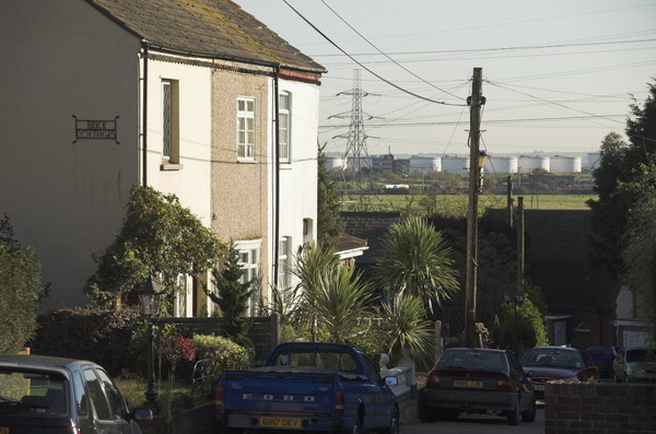
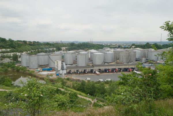
Much of the area is marsh and there are few roads, but it is also the site of Coryton and Thames Haven oil terminals.The building of London Gatway Port began there three years later and it opened in November 2013, “a fully integrated logistics facility” located 30 miles east of London, “able to handle some of the largest container ships in the world.”

Stanford-le-Hope, Corringham, Fobbing and Vange
Lane between Stanford-le-Hope and Corringham

I wasn’t able to access the oil terminals but could see them from a distance both on this ride and on other rides I made to Canvey Island.

Stanford-le-Hope, Corringham, Fobbing and Vange
The distance is dominated by Coryton

Below is what I wrote about the ride in 2005:

Stanford-le-Hope, Corringham, Fobbing and Vange
The Thames estuary across the fields with Kent in the distance. Near Corringham, Thurrock, Essex.

We had some fine weather in the middle of the month, which got me out on my bike again to take a ride around the north side of the Thames estuary, from Stanford-le-Hope – where Joseph Conrad lived and wrote for a couple of years along to Corringham village, then on to Fobbing and past Vange marshes to Pitsea station.

Stanford-le-Hope, Corringham, Fobbing and Vange
The Bell, Corringham

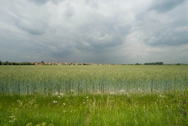
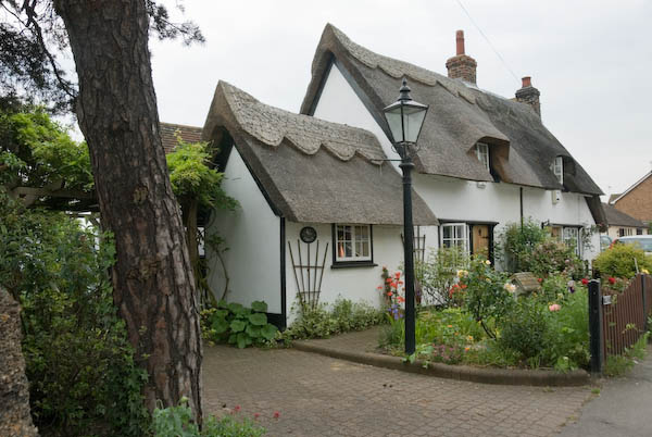
The first miles were on low-lying farmland, with the skyline dominated by the oil tanks and refinery at Coryton (named for the Cory brothers who bought the site in 1923). The old village at Corringham is on a low hill, and parts remain very picturesque. Fobbing has some more serious hills, its main street falling sharply from the church down to the marshes. I took the bike a short way on the footpaths across the marsh, but it wasn’t a suitable surface for riding.

Coryton from Fobbing churchyard

Large-scale development is expected in the area, as the former Shell Haven site, just to the west of Coryton, is to become a large container port, London Gateway.

Peasant’s Revolt memorial arch

In the recreation ground at Fobbing is a memorial arch. In May 1381, a tax collector, Thomas Bampton, came to the village to demand unpaid poll tax from the peasants of Fobbing, Stanford and Corringham; his demands were so unreasonable that this caused a riot and the villagers threw him out.

Coryton and Thames Haven from Vange

By the following day, three of Bampton’s men had been killed and the revolt was spreading through Essex and further afield. News doubtless travelled across the river to Kent, where John Ball had earlier been arrested for his radical views, and Kent peasants also revolted. The arch was erected for the 600 anniversary in 1981. [More about the 1381 Great Rising or Peasant’s Reevolt on Wikipedia]

Fobbing churchyard and view towards Southend

North of the village, Marsh Lane is a bridleway leading out onto the marshes. There had been rather too much rain recently to make cycling along it easy, with large puddles and tractor-churned mud. After around three quarters of a mile, the track became just a grassy footpath and I turned round and made my way back up to the main road on the higher ground overlooking the marsh. [My Brompton soon becomes unrideable on very muddy ground, with mud between the mudguards and tyre locking the wheels – and a difficult job to scrape out.]

Vange is now very cut-off from its marshes, both by the railway line and the A13 road. I’d hoped to explore the marsh a little more, but when my front tyre got a puncture decided to make directly for Pitsea station and the trains home.

More pictures from the ride on My London Diary.


FlickrFacebookMy London DiaryHull PhotosLea ValleyParis
London’s Industrial HeritageLondon Photos

All photographs on this page are copyright © Peter Marshall.
Contact me to buy prints or licence to reproduce.


Rainham, Purfleet, Thurrock & Ponders End – 1993

Rainham, Purfleet, Thurrock & Ponders End: On Saturday 11th December 1993 I took a train from Fenchurch Street to Rainham and then walked along by the river to Coldharbour Point. There the path stopped and I returned to Rainham and took the train to Purfleet where I could pick up the riverside path again and walk on to Grays. Probably I walked about 9 miles in all and by the time I finished it I think the light would have been fading, with sunset at around 4pm.

Tilda Rice, Purfleet, Thurrock, 1993, 94-01-1-64
Tilda Rice, Rainham, Thurrock, 1993, 94-01-1-64

On this walk I made a little over 200 black and white images, a selection of which you can find on Flickr in my 1993 London album beginning here.

Purfleet, Thurrock, 1993, 94-01-1-65
Waste Paper, Purfleet, Thurrock, 1993, 94-01-1-51

There are more colour images from this walk, including a number of panoramas, mixed with pictures from other occasions starting here on the final two pages of my Flickr album of colour pictures from 1993.

Notices on Fence, Purfleet, Thurrock, 1993, 94-01-1-53

But today I found some more pictures from that walk at the start of my album 1994 London Colour and I’ll share these in this post. They will have come from a cassette of film which I took in 1993 but only developed a month or so later in 1994.

Waste Paper, Purfleet, Thurrock, 1993, 94-01-1-56
Works, Purfleet, Thurrock, 1993, 94-01-1-46
QEII Bridge, Dartford Bridge, Pipeline, River Thames, West Thurrock, Thurrock, 1993, 94-01-1-11

The final image in today’s post is something completely different on the same film, a shop window in Ponders End which I found it strangely weird. As it is on the same film as the others I think it was probably also taken in December 1993 although my caption stated 1994.

Shop Window, Ponders End, Enfield, 1994, 94-01-1-14

FlickrFacebookMy London DiaryHull PhotosLea ValleyParis
London’s Industrial HeritageLondon Photos

All photographs on this page are copyright © Peter Marshall.
Contact me to buy prints or licence to reproduce.


Thames Gateway – Essex 2007

Thames Gateway – Essex: I didn’t write much about my bike ride in south Essex on 24th May 2007, though the pictures on My London Diary tell the story of my route. I began at Rainham on the edge of Greater London in the London Borough of Havering.

It wasn’t a linear ride but one where I went back and forth rather extensively exploring some of the areas.

Next came the village of Aveley, where the Old Ship has a pub interior “of Outstanding National Importance” but I didn’t go inside.

I photographed the Mar Dyke at North Stifford along with a number of houses, some thatched and cycled around the Stifford Green estate on site of Stepney Boys Home built around ‘The Tower’. This had been an approved school and then a community home until it closed in 1994.

Next came Chafford Hundred, an area where chalk was extensively quarried from 1874 until the last quarry closeed in 1976. In 1986 a proposal by Blue Circle Industries, West Thurrock Estates and Tunnel Holdings to build 5,000 homes on derelict land was approved and the first were completed in 1989.

Parts of the area were still in industrial use in 2007 and there is a nature park with extensive lakes and ditches.

Lion Gorge, Chafford Hundred

From there I cycled a little deeper into Grays before going to Orsett Fen and Orsett and Horndon on the Hill which has a rather fine old pub I also didn’t go inside. Cycling and beer really don’t mix well with modern traffic.

There are more impressive ancient buildings, a reminder of the wealth that once came from the wool trade.

I made my way via Bulphan towards Upminster where I could use my railcard to start my journey home.


Here is the short text I wrote back in 2007 – with the usual corrections. The cost of the ticket I bought then is now £15.30 – an increase of around 9% above inflation – another of the costs of privatisation.

Thursday I bought an expensive ticket – just up from £6.60 to £7.90 – for a one-day railcard for Greater London from Staines, and put my folding bike aboard the train, changing to reach Rainham, Essex, (L B Havering) on the furthest edge of London from where I live.

Don’t let anyone tell you Essex is flat. O boring. Over a few hundred yards you can move from idyllic thatched cottages to post-industrial dereliction; from dramatic man-made scenery with lakes and chalk gorges to densely packed modern housing estates. From farms owned by city millionaires to council tower blocks.

Most of my winding route took me through Thurrock, one of the major growth sites of the Thames Gateway area.

There are many more images from this ride on My London Diary, beginning here.


FlickrFacebookMy London DiaryHull PhotosLea ValleyParis
London’s Industrial HeritageLondon Photos

All photographs on this page are copyright © Peter Marshall.
Contact me to buy prints or licence to reproduce.