Death at the Elephant

Cyclists die-in where a cycle bypass would have prevented a cyclist death

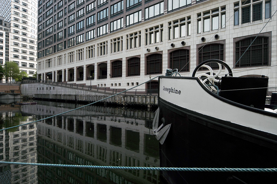
When I was growing up in a working-class area of Greater London there were few private cars around. Only one of my friends was from a family that owned a car, and they could only afford it because both of his parents worked. Working mothers were much looked down on in the area at a time when most married women were housewives, and many employers still expected or even required women to stop work when they got married. There were men in middle-class occupations, but even few of them had cars, walking to local companies or to the station for the train to London. Otherwise people walked to work or took a bus or rode a bike.

My father at the time was self-employed, a man who did odd jobs; a little building work, plastering, plumbing, carpentry, roofing, glazing, electrical wiring, painting, decorating as well as gardening and bee-keeping. He worked for people in our area who mainly were as poor as we were; every penny counted – and there were seldom any spare to count at the end of the week. He rode around on an ancient bike, often with a bucket on the handlebars for his tools, and when he needed a ladder or more equipment or materials, left his bike at home and pulled everything on a hand cart.

For us kids, a bike was a great liberation. We played games on them, sometimes rather dangerously, and rode for miles often along busy main roads. But there was less traffic then and it moved much slower. I got my first two-wheeler – old but newly painted – for my sixth birthday, learnt to ride it that day and was then off, at first along our street and its side avenues, but soon much further afield, either with friends or by myself. By the time I was at grammar school I was riding miles out from London as well as cycling to school.

But things changed. It became the aspiration of many if not all working men to own a car – and more and more married women worked to make it possible. Car makers produced more and more cars aimed at a wider market, something that perhaps began in this country with the 1948 Morris Minor and Ford Popular, introduced in 1953, but accelerated in the late 1950s, when Harold MacMillan told us “most of our people have never had it so good.” Though in 1957 it still had to make its way down to areas like that I lived in.

Riding a bike began to be associated with poverty and cycle clips became an icon of failure. England developed a strong anti-cycling culture, with cyclists becoming an object of derision and hate. They cluttered up the road, preventing the free movement of motor cars. It’s an attitude still prevalent among car owners, and one pandered to by our road designers who until recently largely discounted cyclists in designing roads to enable drivers to drive faster. Pedestrians too were something of a nuisance, to be caged off whenever possible and forced to move away from crossing near corners to motorists could negotiate the rounded profiles at greater speed.

We have seen some changes in recent years. The 2005 bombings made many more consider cycling in cities, and increasing concern about healthy exercise has also led to more recreational cycling – if often by people carrying bikes by car to safer places to cycle. And we now have a few segregated cycle routes in London and elsewhere.But London as a whole is still often a very dangerous place for cyclists (and pedestrians.) One reason is the poor design of many large vehicles with very limited visibility for the drivers. Another is road design inherited from years of ignoring the needs of cyclists and the continuing failure to put enough money into developing roads and paths that are safe for cyclists.

The problems are in part political, with a lack of national leadership and many local politicians remain rabidly anti-cyclist and respond to powerful lobbies from some drivers and in particular taxi drivers organisations. In London it was made worse by the local government reorganisations of the 1960s and the abolition of the Greater London Council in the 1980s. Traffic – including the problems faced by cyclists – is one area that clearly needs to be dealt with for London as a whole and not left to the whim of local boroughs as is currently the case. Some have an almost complete disregard for the safety of cyclists.

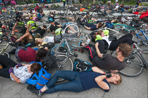
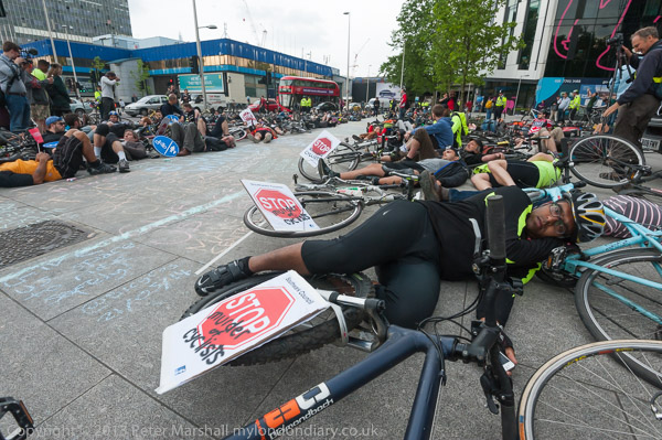
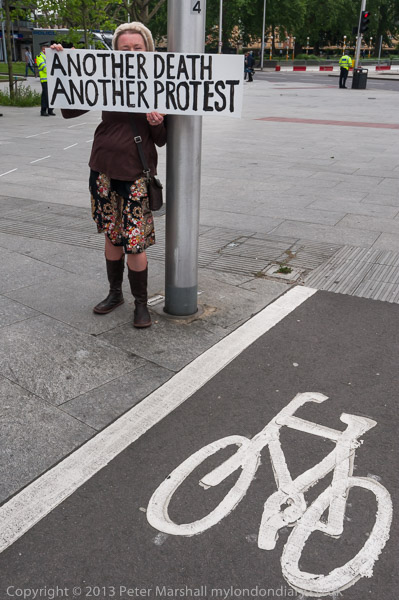
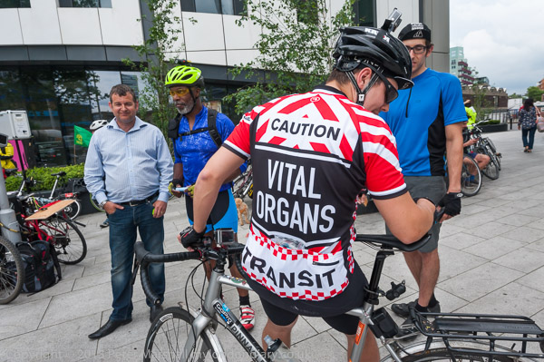
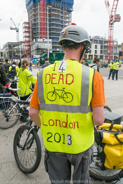
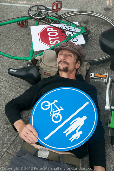
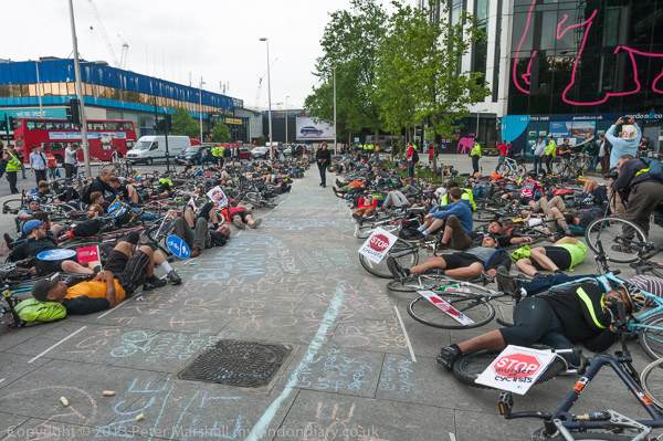
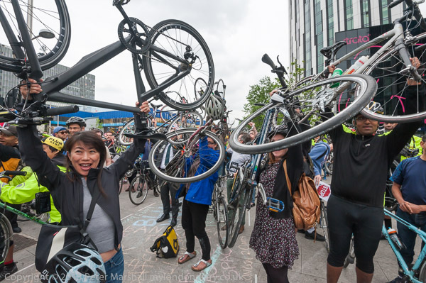
Stop Killing Cyclists has organised a number of bike die-ins taking place shortly after cyclists have been killed at the sites where they died. The protest these pictures come from was at the Elephant and Castle in Southwark on Wednesday 21 May 2014, following the death of 47 year-old Abdelkhars Lahyani on May 13, killed by a HGV (heavy goods vehicle) whose driver was arrested on suspicion of causing death by careless driving.

The traffic system here was completely redesigned a few years earlier at a cost of £3 million, but without making proper provision for cyclists. Southwark Council’s transport plan argues against segregation of cyclists and says that including them in traffic is useful to slow traffic flows. While it may do so, it is at the expense of regarding them as expendable.

The protesters marked out a bike ‘bypass lane’ which if implemented would have taken Lahyani away from the dangerous area where he was killed. Many accidents at junctions are caused by drivers turning left and driving over cyclists they have failed to see on their left side, either in a blind spot because of bad vehicle design or simply because they have failed to check their route before turning.

More at Cyclists protest Death at the Elephant on My London Diary


All photographs on this and my other sites, unless otherwise stated, are taken by and copyright of Peter Marshall, and are available for reproduction or can be bought as prints.


London 20 May 2017

Probably the question I’m most often asked about my photographs of protest is how I find out what is happening. Back in the old days of the last century it was difficult, and I photographed far fewer events. I’m not sure if there were fewer protests, though I think so, but it was certainly then much harder to find out about them. Apart from the printed newsletters and magazines of organisations there were posters pasted illegally on mainly derelict sites around parts of London and the flyers that were handed out at one protest about others in the following months. And word of mouth, again mainly from people I met at protests.

With the Internet, and in particular the World Wide Web and web browsers things began to change, though fairly slowly at first. Organisations slowly began to have web sites and advertise their protests on them; others set up e-mail lists and in 1999 Indymedia began. Google had been founded a year earlier, but there were other search engines more prominent for some years; at the time I was earning money writing for a commercial web site and much of my work depended on web searching to find content to write about – and I also searched for protests, building up a long list of useful sites.

Over the next few years, Google came to dominate web searching and social media began to be more important. By around ten years ago most protests had become Facebook events and much of my diary could be filled in by a search through the events on that platform. Also as I put more of my photographs on-line, at first through Indymedia and later through Facebook and Demotix, I began to get more and more invitations by e-mail and through Facebook to events, some in London and others around the country and world I could not possibly attend. And of those that were in my area I could only cover a fairly small fraction, generally those I saw as most important.

But there were and are those protests I came across by accident, often when covering other events. I’m not sure now whether or not I was aware that 20th May 2017 was Fight Dog Meat Kindness and Compassion Day, but while I’m against torturing animals I would not have gone out of my way to photograph the End dog and cat meat trade protest but was there in Trafalgar Square for Teen Voice says votes at 16, where young people were saying it was unfair they had not been able to vote in the Brexit referendum – while they can work, pay taxes and even join the armed forces they had no say in a decision which will effect their future to an arguably greater extent than anyone who voted.

The protest at The Guardian newspaper was very definitely in my diary, and I was saddened by their coverage of events in Venezuela, which has consistently taken the side of the right-wing middle class in that country against President Maduro and his predecessor Hugo Chávez whose reforms have done so much, decreasing poverty, providing free health care and education, devolving power into the hands of local collectives and building homes for the working class. While reporting on the ‘pro-democracy’ protests which are part of a US-backed right-wing coup it has failed to report their attacks on hospitals, schools and socialist cities which have led to many deaths and the mass demonstrations in favour of the government by working class supporters.

Thanks to the Jubilee Line I was able to travel on to Stratford to photograph Focus E15 launch The Newham Nag, a handout giving some of the facts about Newham Council which somehow were not included in the council’s glossy information sheet. Newham has more homeless than any other local authority in England – one in 27 residents – and more evictions from rented accommodation than any other London Borough. As well as failing housing policies with many homes deliberately kept empty for over ten years, Mayor Robin Wales is also responsible for huge and disastrous expensive long-term loans which mean 80% of council tax from Newham’s residents goes directly in interest payments to the banks.

The protesters here on the wide plaza in front of Stratford Station were harassed by both police and Newham Council officers who made the ridiculous claim they were causing an obstruction in the large uncrowded area and issued them with a £100 fixed penalty notice, part of the ongoing attempt by Newham to silence Focus E15 who continue to throw a spotlight on the activities of Newham Council and Mayor Robin Wales, both a disgrace to the Labour movement. Eventually even Newham Labour could no longer stomach another term for Robin Wales, though his successor has yet to greately improve matters.

Finally it was back on the Central Line to Grosvenor Square, still then the home of the US Embassy, where March Against Monsanto was protesting – along with others in an international day of protest – against the use of genetically modified organisms (GMOs), glyphosate-based herbicide Roundup, dangerous bee-killing neonicotinoid pesticides, and the need for improved protection victims of multinational corporations. It turned out to be a disappointingly small protest even though the then ongoing secreetive TTIP trade talks between the EU and the USA could have lead to a deal which would override our national laws which protect our health and safety and endanger the integrity of our food supplies as well as banning or greatly restricting the traditional practice of farmers saving their own seeds.

March Against Monsanto
Focus E15 launch The Newham Nag
End media lies against Venezuela
Teen Voice says votes at 16
End dog and cat meat trade


All photographs on this and my other sites, unless otherwise stated, are taken by and copyright of Peter Marshall, and are available for reproduction or can be bought as prints.


More Holland Park & Notting Dale 1988

Holland Park Ave, Holland Park, Kensington & Chelsea, 1988 88-1b-44-positive_2400
Holland Park Ave, Holland Park, Kensington & Chelsea, 1988

I made these pictures in January 1988, on one of many walks around various areas of London. At the time I was working on two photographic projects, one in black and white and the other in colour. In black and white I was largely concerned with recording the physical infrastructure, photographing both buildings and streets I felt were exceptional and also examples that I thought were typical. My colour project was more difficult to explain, but both were linked to the changing nature of London.

Holland Park Ave, Holland Park, Kensington & Chelsea, 1988 88-1b-41-positive_2400
Holland Park Ave, Holland Park, Kensington & Chelsea, 1988

January was a good month to take pictures of the streets. One of the smaller projects I’d undertaken was about trees in London, and in the Summer months they hide many of the buildings. Google Streetview is a great resource, but almost all the images around London appear to be from late Spring or Summer, and for some streets almost all you can see is trees. My project on the buildings of London tailed off around 1999 to 2000 because it then seemed to me that it would not be long before we would have something like Streetview with more comprehensive coverage, though it hasn’t entirely replaced the kind of pictures I took.

Holland Park Ave, Holland Park, Kensington & Chelsea, 1988 88-1b-31-positive_2400
Holland Park Ave, Holland Park, Kensington & Chelsea, 1988

Holland Park Avenue is an ancient route to the West from London dating back to before the Romans. In later years until the nineteenth century it was known here as the Uxbridge Road. Land to the south of it was a part of the Holland House estate and from the middle of the 18th century land to the north became owned by the Ladbroke family of wealthy bankers. In 1819 after he inherited the land James Weller Ladbroke began to develop it, beginning with the parts along the Uxbridge Road.

The first houses along the road were built in 1824, but proved difficult to let or sell being so far from the centre of London. Building on the Ladbroke estate halted in the mid-1830s but began again in the following decade. When built, each terrace had its own name and house numbers, but in 1895 this section of Uxbridge Road was renamed Holland Park Avenue and the houses renumbered. You can read more about them on the Ladbroke Association web site.

Holland Rd, Holland Park, Kensington & Chelsea, 1988 88-1a-35-positive_2400
Holland Rd, Holland Park, Kensington & Chelsea, 1988

Holland Road is a rather busy street that leads up from the south to the Holland Park roundabout at the western boundary of Notting Hill and was a part of the Holland estate whose development was carefully overseen by Lord and later Lady Holland. Just to its west is the railway line- now part of the London Overground network as well as carrying National Rail trains and the Underground service as far as Kensington Olympia.

The original plans for the railway in the mid 1830s had it going on a viaduct a short distance to the east close to Addison Road and new houses already built on the Holland estate, and an objection by Lord Holland moved the line to the edge of his estate and largely hidden in a cutting – as well as enabling him to see a few acres to the railway company for £5,000 and get them to largely finance a new covered sewer that ran along Holland Road enabling its development.

Kiln, Walmer Rd, Notting Hill, Kensington & Chelsea, 1988 88-1b-35-positive_2400
Kiln, Walmer Rd, Notting Hill, Kensington & Chelsea, 1988

Walmer Road is the oldest street in Notting Dale, an old footpath which became the main street of the area and was renamed James St in the early 19th century and Walmer Road in the 1850s. Much of the area was dug for clay and bricks and tiles were made here and the area became known as the Potteries – and also because of the pigs kept in the area, the Piggeries. It became a notorious slum area with high levels of cholera, lacking proper sanitation until a new sewer was dug around 1850. The worked out brickfield ‘Ocean’ was filled in in the 1860s, part becoming Avondale Park in 1892. The kiln, a designated Ancient Monument, is opposite the park.

Princedale Rd, Notting Hill, Kensington & Chelsea, 1988 88-1b-21-positive_2400
House, 106, Princedale Rd, Notting Hill, Kensington & Chelsea, 1988

Walmer Road is one of those that was cut short by the building of the Westway and it used to go north to meet Latimer Road. It now comes to an end just south of Grenfell Tower. It’s southern end is also confusing, with a junction with Princedale Road, Kenley Street, Hippodrome Place and Pottery Lane. I think Princedale Rd (formerly Prince’s Rd) along with Pottery Lane may well also have once been part of the old footpath which became Walmer Rd. The two roads run closely parallel and Pottery Lane rather looks like a mews – and its opposite side was once the stables for the racecourse.

Prince’s Road was developed piecemeal between 1841-1851. It became Princedale Road in the late 1930s to remove the confusion with several other Prince’s Roads in London. There are no listed buildings in the road which in 1978 became part of the Norland Conservation Area.

Shop, Portland Rd, Clarendon Cross, Notting Hill, Kensington & Chelsea, 1988 88-1b-11-positive_2400
Shop, Portland Rd, Clarendon Cross, Notting Hill, Kensington & Chelsea, 1988

This shop on the corner of Portland Road and Clarenden Cross is still there with its half pots and name ‘Fired Earth’ a reminder of the origin of the area as the ‘Potteries’, about a hundred yards from the remaining kiln in a picture above.

My introduction to this area came in the book ‘Absolute Beginners’ by Colin MacInnes published in 1959 which I read when I was a teenager and which is loosely based around the Notting Hill race riots of 1958, later filmed. It has rather gone up in the world since then.


All photographs on this and my other sites, unless otherwise stated, are taken by and copyright of Peter Marshall, and are available for reproduction or can be bought as prints.


Ladbroke Estate: 1988

Stanley Crescent, Notting Hill, Kensington & Chelsea, 1988 88-1c-33-positive_2400
Stanley Crescent, Notting Hill, Kensington & Chelsea, 1988

When James Weller Ladbroke inherited his 300 acre largely rural estate on the western edge of London in 1819 he wanted to develop the area and employed landscape architect Thomas Allason to draw up a picturesque plan based on his visits to Italy and the London example of John Nash’s Regent’s Park. It was a plan that Ladbroke never found the money to build, but influenced some of those the estate sold land to and can still be seen in the map of the area, most of which was built up in the 1850s with large villas and terraces and in parts retained the communal private gardens between the streets.

Stanley Gardens, Notting Hill, Kensington & Chelsea, 1988 88-1c-25-positive_2400
Stanley Gardens, Notting Hill, Kensington & Chelsea, 1988

Stanley Crescent and Stanley Gardens were developed by Charles Blake, who returned from running a highly profitable business in India and bought the area from Felix Ladbroke in 1852. He got artist and architect Thomas Allom to design the area based on Allason’s plans.

The streets were probably named after Lord Stanley who was Prime Minister in three separate short governments from 1852 on. In them he abolished slavery and reformed Parliment and created the modern Conservative party. Building began in 1853.

Stanley Crescent, Notting Hill, Kensington & Chelsea, 1988 88-1c-13-positive_2400
Stanley Crescent, Notting Hill, Kensington & Chelsea, 1988

Allom was architect for the houses on the estate and, according to the Survey of London his designs broke away from the late Georgian restraint of earlier streets inn the area “in favour of a grand display in the latest taste … with scenic effect uppermost in his mind. The design of houses, streets, gardens and tree planting is seen with a painter’s eye, so that each turn and every vista is composed in a picturesque manner…”

Lansdowne Rd, Notting Hill, Kensington & Chelsea, 1988 88-1b-65-positive_2400
Lansdowne Rd, Notting Hill, Kensington & Chelsea, 1988

Most of the houses remained in single ownership until after the First World War, when costs of upkeep became ridiculous and they were converted for multi-occupation and often allowed to deteriorate. By the time I took these pictures this process was in reverse, with houses being renovated and wealthier tenants paying considerably higher rents and some houses converted back to single family occupancy as the area became popular among the ultra-rich.

You can read a detailed account of the houses, many of which are listed on the Ladbroke Association web site.

Lansdowne Rd, Notting Hill, Kensington & Chelsea, 1988 88-1b-56-positive_2400
Lansdowne Rd, Notting Hill, Kensington & Chelsea, 1988

Landsdowne Road was also a part of the Ladbroke Estate, built around 10 years earlier than Stanley Crescent in the 1840s, while the estate was still owned by James Weller Ladbroke. He let plots to various developers to build, and the road lacks the overall view of the later area, with some quite varied houses. This suggests that the name ‘Landsdowne’ comes from “the much admired Montpellier and Lansdown residential estates in Cheltenham, built in the first three decades of the 19th century”. Alternatively it might have been named for another prime minister, William Petty, Earle of Shelburne, who served briefly in 1782-3, after which he was made 1st Marquess of Lansdowne. His major achievement as prime minister was securing a treaty which lead to the end of the American War of Independence.

Lansdowne Rd, Notting Hill, Kensington & Chelsea, 1988 88-1b-54-positive_2400
Lansdowne Rd, Notting Hill, Kensington & Chelsea, 1988

Again you can read a detailed account of the buildings on the street on the http://www.ladbrokeassociation.info/LansdowneRoad.htm Ladbroke Association web site.

Lansdowne Rd, Notting Hill, Kensington & Chelsea, 1988 88-1b-52-positive_2400
Lansdowne Rd, Notting Hill, Kensington & Chelsea, 1988

When I was taking these pictures in 1988, information about this and many other areas of London was relatively hard to find. There was of course no World Wide Web and few books with any detailed description outside the City of London and some parts of Westminster. The volume of The Buildings of England by Cherry and Pevsner for this area was only published in 1991. In areas such as this, almost all I had to guide me was the A-Z and other street maps.


All photographs on this and my other sites, unless otherwise stated, are taken by and copyright of Peter Marshall, and are available for reproduction or can be bought as prints.


Shepherds Bush 1988

I’ve always found Shepherds Bush confusing. My first visits to the area were infrequent trips with my mother to visit an elderly woman relative who lived alone in a flat on the Goldhawk Rd, an exiting visit, travelling to Hammersmith on the tube and then a bus. And it was a secret mission on which I was sworn to silence; Blanche had been ostracised by all her relations except my mother. This was around 1950 and divorce was still seen by many as something shocking. I remember being rather disappointed to find this ‘scarlet woman’ was much the same colour as me.

Subway, Shepherds Bush, Roundabout, Hammersmith & Fulham, 1988 88-1d-44-positive_2400
Subway, Shepherds Bush, Roundabout, Hammersmith & Fulham, 1988

Sheep could certainly not safely graze at Shepherds Bush, and were best keeping well out of trouble on this arch above the subway under the M41 West Cross Route, built as part of Ringway 1, part of a series of motorway rings which would have destroyed London. The damage they would cause became very apparent during the building of the Westway and West Cross Route and the scheme was abandoned, with fortunately only a few sections completed. The road was demoted to the A3220 in 2000 but cyclists are still prohibited. The subway is immediately to the north of the Holland Park roundabout.

Subway, Shepherds Bush, Roundabout, Hammersmith & Fulham, 1988 88-1a-22-positive_2400
Subway, Shepherds Bush, Roundabout, Hammersmith & Fulham, 1988

Eight years later, in July 1996, I returned here together with around 6,000 others to hold a party and protest on the M41 here which blocked the road for over 8 hours. I left before it ended, climbing over a wall and ending up on Freston Road, taking the Underground to Hammersmith from Latimer Road Station.

Shepherds Bush Station, Uxbridge Rd, Shepherds Bush, Hammersmith & FUlham, 1988 88-1c-42-positive_2400
Shepherds Bush Station, Uxbridge Rd, Shepherds Bush, Hammersmith & Fulham, 1988

One of the confusing things about Shepherds Bush were the two Underground stations around 500 yards apart and on different lines, but both named Shepherds Bush. I think both were built around 1900. The Central Line station in the picture was replaced by a new station in 2008, and the Hammersmith & City station was then renamed Shepherd’s Bush Market.

Shepherds Bush Green, Shepherds Bush, Hammersmith & Fulham, 1988 88-1c-56-positive_2400
Footbridge, Shepherds Bush Green, Shepherds Bush, Hammersmith & Fulham, 1988

The footbridge leading across Shepherds Bush close to the Central Line Station to the large 1967 shopping centre on its south side added to the confusion with a giant Intercity 125 Train on its side, despite it leading to the Concorde shoppint centre. It confused me still more by disappearing completely two years after I too its picture, plagued with problems as the escalators kept breaking down and a few people found it funny to drop things from it onto passing traffic.

There are still two quite separate stations called Shepherds Bush, as a new National Rail Shepherds Bush station opened close to the Central Line station in 2008. It had been meant to open as a Silverlink station on the line from Clapham Junction to Willesden Junction in 2007, but when completed they found one platform was 18 inches less wide than safety regulations required. By the time this was put right the following year it was a part of the London Overground. Perhaps had this change been anticipated it would have been designed with a tunnel leading the the Underground station rather than having to go through two ticket barriers and across a roadway busy with buses to change trains here.

Shepherds Bush, Hammersmith & Fulham, 1988 88-1a-25-positive_2400
Providence Capital, Shepherds Bush, Hammersmith & Fulham, 1988

The station developments were for the opening of the huge Westfield shopping centre on the White City site. Although the new Overground station was built on the site of the long-disused Uxbridge Road station it required the demolition of the building I rather liked close to the Holland Park roundabout. Its design as a giant gate echoes in plain form the excessively ornate gateway built here at Shepherd Bush for the 1908 Franco-British Exhibition at White City which attracted over eight million paying customers, and I believe this was indeed a much slimmed-down version of the entrance to the exhibition halls, converted for office use.


All photographs on this and my other sites, unless otherwise stated, are taken by and copyright of Peter Marshall, and are available for reproduction or can be bought as prints.


Rally For Jerusalem – Save Sheikh Jarrah

Rally For Jerusalem - Save Sheikh Jarrah, London, UK

Like many I’ve been shocked at the accounts, pictures and videos coming from Jerusalem and elsewhere in Israel and occupied Palestine, particularly Gaza, in recent days, and on Tuesday 11th May 2021 I went to Whitehall to cover the emergency protest there, the ‘Rally For Jerusalem – Save Sheikh Jarrah’ .

Rally For Jerusalem - Save Sheikh Jarrah, London, UK

The event was called by the Palestine Solidarity Campaign UK, Friends of Al Aqsa, Stop the War Coalition and Palestinian Forum in Britain, and supported by a wide range of other groups.

Rally For Jerusalem - Save Sheikh Jarrah, London, UK

Several thousand had turned up and more were arriving as I left to go home after a little over an hour, as I was getting rather tired. Police had tried at first to keep Whitehall open for traffic, but it was soon clear that there were just too many people to allow that, and first one carriageway and then both were stopped by people spilling out into the road. It also seemed very likely that later there would be some confrontations if police tried to move the protesters. But it was a peaceful protest with many families and children present and there seemed little need for any police intervention other than some increased security of a few key sites – such as the gates and armed police at Downing St. It is important to protect the public from them.

Rally For Jerusalem - Save Sheikh Jarrah, London, UK

I listened to a few speakers and photographed some of them, including a Palestinian woman who had grown up in Sheikh Jarrah, rapper Lowkey and Glyn Secker of Jews for Justice for Palestinians, but moved away to photograph in the crowd before the main speakers arrived.

Rally For Jerusalem - Save Sheikh Jarrah, London, UK

As usual a group of Neturei Karta Jews had come to support Palestinian rights against Zionism which they see as the cause of bloodshed in Israel, and there were also other Jewish groups who had come to protest against the actions of the Israeli police force and the Israeli government who have launched disproportionate attacks on Gaza, with air strikes killing over 30 people, including many women and children, and demolishing homes.

Rally For Jerusalem - Save Sheikh Jarrah, London, UK

I missed the speech by Jeremy Corbyn, in which he called for an end to the occupation of Palestine and the recognition of the Palestinian state, but he tweeted earlier in the day:

Deliberately provocative attacks on the Al-Aqsa mosque and the ongoing home invasions #SheikhJarrah have led to horrendous violence in Jerusalem. As the occupying power, the Israeli government has it in its gift to rectify the current situation and not exacerbate it. #Palestine

https://twitter.com/jeremycorbyn/status/1392043526066774020
Rally For Jerusalem - Save Sheikh Jarrah, London, UK

Saturday 15th May is Nakba Day, and there will be a large march in London today, gathering at Marble Arch at noon and marching towards the Israeli embassy against the continuing repression and attacks on Palestinians in Jerusalem and in Gaza and elsewhere in occupied Israel. I’ve put almost 50 of my pictures from Tuesday including those above into a Flickr album, Rally For Jerusalem – Save Sheikh Jarrah.


All photographs on this and my other sites, unless otherwise stated, are taken by and copyright of Peter Marshall, and are available for reproduction or can be bought as prints.


London 14 May 2016

Class War at UVW protest against Topshop sacking and suspensions of cleaners

May 14 has always been a special day for me, and five years ago I celebrated my birthday on the streets of London photographing various protests around town before going home to a more private event. The day’s work ended for me on Oxford St, where the United Voices of the World union were protesting against Philip Green’s Topshop after members who work as cleaners were suspended and one sacked for their union activities – demanding the London Living Wage. The protest was supported by other groups including Class War, cleaners from the CAIWU and other trade unionists including Ian Hodson, General Secretary of the BWAFU and Shadow Chancellor John McDonnell. Although Philip Green makes millions, the cleaners were on the national minimum of £6.70 per hour, nothing like a enough to live on in London.

Police were out in force to prevent the protesters entering the Topshop store and there was a noisy protest on the pavement for some time facing the line of police before Class War led the protesters into the centre of the road to block Oxford St.

Police tried to clear the road, and began threatening arrests and the protesters decided to march west down Oxford St, briefly blocking Oxford Circus

before stopping to protest outside John Lewis, where the UVW have been campaigning for several years to get the cleaners recognised as a part of the workforce with similar respect and conditions of service to other John Lewis staff.

There were heated arguments as police manhandled some of the protesters there, but things calmed down a little and the campaigners moved on for a final protest outside the Marble Arch Topshop.

Things seemed to be coming to an end and I was late for dinner so I hurried away.

My day’s work had begun in Holloway, where Islington Hands Off Our Public Services, Islington Kill the Housing Bill and the Reclaim Justice Network were holding a rally and march to HMP Holloway, demanding that when the prison closed the site be used for much-needed social housing and community facilities, rather than for expensive private flats. Local MP and Labour Party leader Jeremy Corbyn rode up on his bike to speak at the rally.

I moved on from the rally at the end of the march outside Holloway Prison to Oxford St, where the Revolutionary Communist Group and friends were reminding shoppers of the continuing oppression of the Palestinian people, and opposing attempts to criminalise and censor the anti-Zionist boycott, divestment and sanctions (BDS) movement. The rolling picket urged shoppers to boycott stores which support and fund Israel, including Marks and Spencer, and stopped for brief speeches in front of some of them for short speeches.

A small group of militant Zionists had come along to wave Israeli flags and shout insults at them. The protesters (who included several Jews and some Palestinians) made clear that this was not an anti-Semitic protest but against some actions of the Israeli government and it took place the day before Nabka Day, the ‘day of the catastrophe’, remembering when roughly 80% of the Palestinian population were forced to leave their homes between December 1947 and January 1949, and later prevented by Israeli law from returning to their homes, or claiming their property. This year the attacks on Palestinians in Jerusalem have largely been precipitated by the continuing attempts by Jewish settlers to displace the Palestinian population of Sheikh Jarrah in East Jerusalem. Founded in 1865, the area became home to Jerusalem’s Muslim elite, but in 1948 became home to Palestinian refugees from Jerusalem.

Vegans had come to Trafalgar Square holding laptops and tablets and wearing masks to show the film ‘Earthlings’ which includes scenes of horrific cruelty to animals and calling for an end to the farming and eating of animals. Some also pointed out the contribution that becoming vegan could make towards solving the climate crisis as Vegan dietts use less water, land and grain and produce less CO2.

Also on the North Terrace of Trafalgar Square were a small group of protesters standing in front of the National Gallery who held posters calling for human rights, fair treatment and support for refugees. Some held a banner with the message ‘free movement for People Not Weapons’.

More about all these protests on My London Diary:

Topshop protest after cleaners sacked
Refugees Welcome say protesters
Vegan Earthlings masked video protest
68th Anniversary Nabka Day
Reclaim Holloway

Holland Park & Notting Hill

Holland Park, Holland Park, Kensington, Kensington & Chelsea, 1988 88-1d-64-positive_2400
Holland Park, Holland Park, Kensington, Kensington & Chelsea, 1988

Holland Park is a street in London as well as an actual park and the name of a tube station which has transferred to an area of Kensington to the west of Notting Hill. Virtually every house in the street is listed – I think 88 of them. The exception is the Greek Embassy at No.1. This had been the most interesting house in the street. Built in 1860 it was bought in 1864 by banker Alexander C. Ionides (1810-1890), who had been Greek Consul General in London from 1854 to 1856. He and his son who inherited the house were wealthy Greek business men and patrons of the arts – and from 1864 and they transformed the property, commisioning external work leading Victorian architect Philip Webb, who also gave it a grand staircase and other fine public rooms, with internal decorative work by the leading figures of the day, including Willliam Morris who supervised much of the work and whose company provided much of it. It became a meeting-place for all London’s leading artists coming to its Sunday open house in the 1880s and 90s. The family moved out in 1898 and the house was sold a few years late.

Holland Park, Holland Park, Kensington, Kensington & Chelsea, 1988 88-1d-61-positive_2400
Holland Park, Holland Park, Kensington, Kensington & Chelsea, 1988

The interior of 1 Holland Park was meticulously recorded by the leading architectural photographer of the day, Henry Bedford Lemere as well as in the work of others. But the new owners – who were also the owners of nearby Holland House – did not treat it well, whitewashing over the William Morris ceilings. The house was badly damaged by bombing in WW2 and was sold with Holland House and the park to the London County Council in 1952, when it was reported that little worth preserving remained and the house was demolished. The building which now houses the Greek Embassy was built in 1962 by architects Playne & Lacey and bought by Greece in 1973. An article available online gives muuch more detail on the Ionides family and the house

Holland Park Mews, Holland Park, Kensington, Kensington & Chelsea, 1988 88-1d-63-positive_2400
Holland Park Mews, Holland Park, Kensington, Kensington & Chelsea, 1988

Holland Park is actually two parallel streets, each stuffed with listed houses, built under the watchful eye of Lady Holland who saw to it that they met her standards, though at the time they were not felt to be anything special – typical houses for the wealthy. And the wealthy needed carriages which required to be kept at hand, along with the horses to draw them. They and the men who looked after them lived in the mews between the two streets, and would be drive the carriages around when required to the front doors – and the rich would emerge from those iron and glass porte cochères to ride in them.

Stoneleigh Place, Notting Hill, Kensington & Chelsea, 1988 88-1d-35-positive_2400
Stoneleigh Place, Notting Hill, Kensington & Chelsea, 1988

A short distance north of Holland Park, some housing is on a less grand scale.

Freston Rd, Notting Hill, Kensington & Chelsea, 1988 88-1d-24-positive_2400
Freston Rd, Notting Hill, Kensington & Chelsea, 1988

Another picture from Freston Road. The London City Mission built The People’s Hall on Latimer Road in the Kensington Piggeries in 1902, when parts of the area were one of the worst slums in London. This part of Latimer Road was renamed Freston Road when the construction of the Westway and the West Cross Route cut it in half. The hall on the corner of Olaf St became the centre of the Free and Independent Republic of Frestonia in 1977. Probably it’s best known now as the place where much of The Clash’s album Combat Rock was recorded.

Royal Crescent, Notting Hill, Kensington & Chelsea, 1988 88-1c-61-positive_2400
Royal Crescent, Notting Hill, Kensington & Chelsea, 1988

Royal Crescent is at the western edge of Holland Park/Notting Hill, just to the north of Holland Park Avenue, just east of the Holland Park roundabout. It was one of the earliest parts of the Norland Estate to be developed in the 1840s, to the estate plan of Robert Cantwell and is Grade II* listed. It took a long time to rent these properties, which were thought to be too far out from London in the days of horse-drawn traffic for the wealthy.

St Ann's Villas, Notting Hill, Kensington & Chelsea, 1988 88-1d-32-positive_2400
St Ann’s Villas, Notting Hill, Kensington & Chelsea, 1988

St Anne’s Villas leads north from the centre of the Royal Crescent, and is on one of the routes I’ve sometimes walked more recently from Shepherd’s Bush station to join the silent walks remembering Grenfell.

St Ann's Villas, Notting Hill, Kensington & Chelsea, 1988 88-1c-52-positive_2400
St Ann’s Villas, Notting Hill, Kensington & Chelsea, 1988

St Anne’s Villas were built as a part of the Norland Estate, mainly around 1845. The area was developed by by Charles Richardson with barrister Charles Stewart taking building licences from him for these Tudor Gothic revival semi-deatched houses, now Grade II listed.


All photographs on this and my other sites, unless otherwise stated, are taken by and copyright of Peter Marshall, and are available for reproduction or can be bought as prints.


Notting Hill – Notting Dale – 1988

Nottingwood House, Clarendon Rd, Notting Hill, Kensington & Chelsea, 1988 88-1e-62-positive_2400
Nottingwood House, Clarendon Rd, Notting Hill, Kensington & Chelsea, 1988

Notting Hill – and the London Borough of Kensington & Chelsea – is very much a place of two halves and these two pictures illustrate this, with the large block of council housing built on the site of the Notting Hill brewery and other industrial buildings shortly before the war.

Houses, Blenheim Crescent, Clarendon Rd, Notting Hill, Kensington & Chelsea, 1988 88-1e-61-positive_2400
Houses, Blenheim Crescent, Clarendon Rd, Notting Hill, Kensington & Chelsea, 1988

This picture was taken from roughly the same place as the previous picture, but from the opposite side of the road. Houses in Blenheim Crescent are currently on sale for £4 million. Of course many of the social housing tenants in Nottingwood House took advantage of Thatcher’s social housing giveaway ‘Right to Buy’, though quite a few then found themselves needing to sell these properties, with many becoming ‘buy to let’ properties – now at perhaps £2000 a month, and other flats on sale for perhaps £800,000, so the difference here is rather less real than when I made this picture.

Bramley Arms, Bramley Rd, Freston Rd, Notting Hill, Kensington & Chelsea, 1988 88-1e-53-positive_2400
Bramley Arms, Bramley Rd, Freston Rd, Notting Hill, Kensington & Chelsea, 1988

I think the pub had closed shortly before I took this picture. The building is still there but is now offices with flats on the upper floor. The pub has appeared in at least five major films including Sid and Nancy (1986), Quadrophenia (1979) and The Lavender Hill Mob (1951) as well as TV series.

This area was cut off on two sides by the construction of the Westway and the West Cross Route in the 1960s and became very run down and what had been the southerns section of Latimer Rd was renamed Freston Road. Oddly, Latimer Road station (on Bramley Rd) was not renamed, though it is no longer close to Latimer Road. In 1977 squatters occupied houses and flats the GLC planned to demolish in Freston Road and declared the Republic of Frestonia. The GLC granted them temporary leave to remain and the area was developed more sensitively by the Bramley Housing Co-operative from 1985. You can see the ‘Underground’ bridges in the distance on both streets in this photograph.

Freston Rd, Notting Hill, Kensington & Chelsea, 1988 88-1e-52-positive_2400

This neat and unpretentious factory building is still present on the corner of Freston Rd and Evesham Rd, but now surrounded by a large redevelopment and painted a dull grey.

Mural, Harrow Club, Freston Rd, Notting Hill, Kensington & Chelsea, 1988 88-1e-45-positive_2400
Mural, Harrow Club, Freston Rd, Notting Hill, Kensington & Chelsea, 1988

Although the area around and under the Westway was fairly desolate in 1988, attempts had been made to brighten the area with a number of well painted murals. The Harrow club was set up by former pupils of Harrow School in 1883 as The Harrow Mission Church “to improve the quality of life for local people, aiding harmony and promoting opportunity” for the people of Notting Dale and continues to do so.

Freston Rd, Westway, Notting Hill, Kensington & Chelsea, 1988 88-1e-44-positive_2400

More graffiti.

Freston Rd,, Stable Way, Westway, Notting Hill, Kensington & Chelsea, 1988 88-1e-35-positive_2400

The caravans are around Stable Way. The car is coming down a link road from the Westway which runs across the top of the picture to the West Cross Route. This is the edge of a BMX cycle circuit at the north end of Freston Rd.

Freston Rd, Westway, Notting Hill, Kensington & Chelsea, 1988 88-1e-32-positive_2400

Another picture from the BMX track beyond the end of Freston Road, close to the Westway junction with the West Cross Route.

Freston Rd, Westway, Notting Hill, Kensington & Chelsea, 1988 88-1e-31-positive_2400

This picture gives a more informative view of the location, though I can find no trace of this oval now, but it was I think a part of the BMX circuit at the north end of Freston Rd.

Freston Rd,, Westway, Notting Hill, Kensington & Chelsea, 1988 88-1e-23-positive_2400

The landscaped area here is at the end of Freston Rd, with the Harrow Club at left.

Westway, Notting Hill, Kensington & Chelsea, 1988 88-1e-14-positive_2400

Underneath the Westway and the links from the West Cross Route.

Westway, Notting Hill, Kensington & Chelsea, 1988 88-1e-13-positive_2400

Various sports facilities underneath the motorway junction. Opened in 1970 as the A40(M) its status was downgraded in 2000 to an all-purpose road. There were plans to include a separated cycleway on parts of it announced in 2013 but these were scrapped in 2017. However Kensington & Chelsea Council have opposed all protected cycle routes on their streets, and even scrapped a temporary route which was implemented during the Covid lockdown.

More from the other half of Notting Hill in another post.


All photographs on this and my other sites, unless otherwise stated, are taken by and copyright of Peter Marshall, and are available for reproduction or can be bought as prints.


Photography Workshop 9th May 2004

I hope those who came with me on the workshop I led around a part of London’s Dockland 17 years ago found it stimulating. For me it was a familiar walk, but I think most of the others were seeing the area for the first time. One of the instructions for the workshop some will have found difficult was not to bring a tripod, as these were and are red rags to the security staff who closely patrol the Canary Wharf estate. We had no problems with security on this workshop, though I have had confrontations on other occasions – including being once escorted off the estate.

I think I had been asked to run the workshop for London Independent Photography, though I’m not sure. On My London Diary I put a short text about the event and some pictures that I made during it. I’ve corrected the spelling and capitalisation of the original, otherwise it is exactly as written, probably deliberately in part ungrammatically.

May 9 found me taking a group of photographers for a walk around some parts of London’s docklands. we started at the centre of this ‘crime of the century’. I still don’t quite understand why a Conservative government felt so at odds with the City of London that it decided to set up offshore competition in the Enterprise Zone.

The feeding frenzy that ensued, trousering public property and tax breaks into the private pocket at an unprecedented rate.

The long-term consequence has been a distorted development with few real buildings of distinction but some expensively finished tat, and a lack of overall planning. I’m not sure that London would benefit from gaining the Olympics for which it is currently bidding, but if it fails, probably part of the reason will be the docklands debacle.

We started below the obscene gesture towards the old city, at least clear about its symbolism, then took the DLR down to Crossharbour with its silly bridge, walking back to the wharf and taking the Jubilee to Canning Town. then back alongside the Lea (still waiting for that riverside walkway) to East India Dock Basin and along by the Thames, where a galleon appeared in front of the dome.

My London Diary – May 2004

Docklands has continued to change since 2004, but it remains a largely lost opportunity to develop what had become the redundant area for the benefit of the people as a whole rather than to enrich a few.


Back in 2004 I was still working with my first DSLR, the Nikon D100 for which had recently bought the Sigma 12-24mm lens and on this DX format camera this gave effective focal lengths of 18-36mm. The smaller format also avoids the weaker corners of this extreme wide-angle zoom (I think the first of its type) and within the smaller field it was remarkably distortion-free. There are a few more pictures on My London Diary – including that galleon – some rendered rather dully by the RAW software of the time – I’ve improved the rendering of those included in this post.


All photographs on this and my other sites, unless otherwise stated, are taken by and copyright of Peter Marshall, and are available for reproduction or can be bought as prints.